Browse Listings in America > North America

Tierra Nueva.
Uncommon first edition of this early map of the east coast is an enlarged version of Giacomo Gastaldi map published in 1548. Nomenclature and cartography are unchanged, w...
- $1000 / ≈ €936
Place & Date: Venice, 1561

La Florida/ Peruviae Auriferae regionis Typus/ Guastecan.
The Chaves map of Florida is a prime example of an explorer's map since it records the recent discoveries of Cabeza de Vaca, De Soto, and Moscoso. The map revealed little...
- $1400 / ≈ €1310
Place & Date: Antwerp, 1592

La Florida/ Peruviae Auriferae regionis Typus/ Guastecan.
The Chaves map of Florida is a prime example of an explorer's map since it records the recent discoveries of Cabeza de Vaca, De Soto, and Moscoso. The map revealed little...
Place & Date: Antwerp, 1592
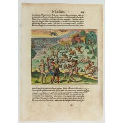
Cacodemon attacking the savages.
Cacodemon ("evil spirit") attacking the savages. Read more about "Les Grand Voyages" by Theodore De Bry [+]
- $200 / ≈ €187
Place & Date: Frankfurt, 1594
![Arcis Carolinae delineatio [Jacksonville]](/uploads/cache/48530-250x250.jpg)
Arcis Carolinae delineatio [Jacksonville]
Depicting Fort Caroline in Jacksonville, Florida. A French expedition, organized by Protestant leader Admiral Gaspard de Coligny and led by the French Explorer Jean Ribau...
- $400 / ≈ €374
Place & Date: Frankfurt, 1594
![[The French left in Fort Charles suffer the scarcity of provisions.]](/uploads/cache/48529-250x250.jpg)
[The French left in Fort Charles suffer the scarcity of provisions.]
An Indian town visited by the French of Charlesfort in search for food. After a drawing by LeMoyne. Charlesfort-Santa Elena is on what is now Parris Island, South Carolin...
- $400 / ≈ €374
Place & Date: Frankfurt, 1594
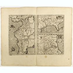
La Florida/ Peruviae Auriferae regionis Typus/ Guastecan.
The Chaves map of Florida is a prime example of an explorer's map since it records the recent discoveries of Cabeza de Vaca, De Soto, and Moscoso. The map revealed little...
Place & Date: Antwerp, 1598

Polus Arcticus cum vicinis regionibus.
Map of the North Pole regions from the 1608 second edition of Jodocus Hondius' Atlas Minor.A reduction of the 1606 Mercator-Hondius folio map (which is a later state of t...
Place & Date: Amsterdam, 1608
Selling price: $500
Sold in 2012

Tartariae sive Magni Chami Imperium.
This is a very early depiction of the northern Pacific, with the first mapping of Northwest Coast of America and probably the first map to name California 'C. Califormio...
- $2500 / ≈ €2339
Place & Date: Antwerp, c. 1608-1612
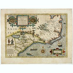
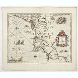
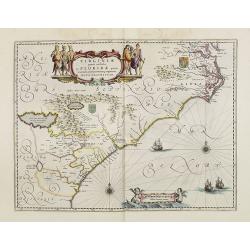
Virginiae item et Floridae. . .
Cummings describes it as one of the most beautifully executed maps ever made of the Southeast. In detail and in general conception it surpasses all earlier maps of the re...
- $2500 / ≈ €2339
Place & Date: Amsterdam, 1630
Virginiae item et Floridae . . .
Map of Virginia from the rare Cloppenburg edition slightly larger format and more scarce edition of the Mercator/Hondius "Atlas Minor". Engraved by Pieter Van D...
- $750 / ≈ €702
Place & Date: Amsterdam, 1630
![[American history plate].](/uploads/cache/40176-250x250.jpg)
[American history plate].
Scarce print (150x177mm.) on a German text sheet taken from a first edition of Johann Ludwig Gottfried's "Newe Welt Vnd Americanische Historien/ Jnhaltende Warhaffti...
- $80 / ≈ €75
Place & Date: Frankfurt, M.Merian, 1633
![[Moose].](/uploads/cache/40180-250x250.jpg)
[Moose].
Scarce print (150x177mm.) of a Moose on a German text sheet taken from a first edition of Johann Ludwig Gottfried's "Newe Welt Vnd Americanische Historien/ Jnhaltend...
- $100 / ≈ €94
Place & Date: Frankfurt, M.Merian, 1633
![[The manner of making their boats.]](/uploads/cache/40467-250x250.jpg)
[The manner of making their boats.]
The manner of making boats in Virginia is wonderful to behold. They were able to do so without using any iron tool at all. First they chose a tall tree, wide enough for a...
Place & Date: Frankfurt, M.Merian, 1633
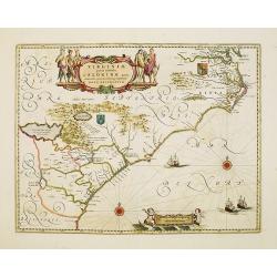
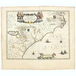
Virginiae Partis Australis, et Floridae Partis Orientalis.
Blaeu based this map on the Mercator-Hondius of 1606. A number of geographical improvements, however were incorporated, although two large fictions lakes accompanied by e...
- $1800 / ≈ €1684
Place & Date: Amsterdam, 1640
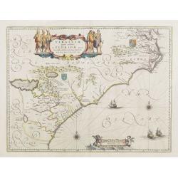
Virginiae Partis Australis, et Floridae Partis Orientalis.
Blaeu based this map on the Mercator-Hondius of 1606. A number of geographical improvements, however were incorporated, although two large fictions lakes accompanied by e...
Place & Date: Amsterdam, 1640

Virginiae Partis Australis, et Floridae Partis Orientalis.
Blaeu based this map on the Mercator-Hondius of 1606. A number of geographical improvements, however were incorporated, although two large fictions lakes accompanied by e...
Place & Date: Amsterdam, 1640

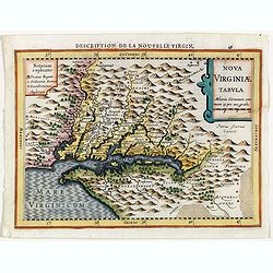
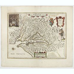
Nova Virginiae Tabula.
A fine example of Blaeu's map of Virginia and the Chesapeake region is based on the first state of Smith's map, 1612, and is slightly larger and more expertly engraved.Th...
Place & Date: Amsterdam, 1640
Nova Belgica et Anglia Nova.
Orientated with north to the right. This is one of the earliest maps to concentrate solely on this area of the colonies, excluding Virginia and the extreme north east coa...
- $4500 / ≈ €4211
Place & Date: Amsterdam, 1644
Nova Virginiae Tabula.
The map is based on the first state of Smith's map, 1612, and is slightly larger and more expertly engraved. In 1629 the Hondius plate was purchased by Blaeu who deleted ...
Place & Date: Amsterdam, 1644
Virginiae Partis Australis, et Floridae Partis Orientalis.
Blaeu based this map on the Mercator-Hondius of 1606. A number of geographical improvements, however were incorporated, although two large fictions lakes accompanied by e...
- $2000 / ≈ €1871
Place & Date: Amsterdam, 1644

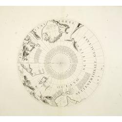
Les deux poles articque ou septentrional et antarticque..
A double hemisphere map to the North and South poles. The North pole is connected to Greenland and Spitzbergen but there is little other detailed coastline in the polar a...
Place & Date: Paris, 1657
Virginiae Partis Australis, et Floridae Partis Orientalis.
Blaeu based this map on the Mercator-Hondius of 1606. A number of geographical improvements, however were incorporated, although two large fictions lakes accompanied by e...
- $1500 / ≈ €1404
Place & Date: Amsterdam, 1658

Poli Arctici, et circumiacentium terrarum descriptio novissima. . .
A re-issue of the Hondius' plate. A particularly decorative map of the North Pole with Iceland. Several Dutch names in Labrador. The toponymy in Canada reflects the conti...
Place & Date: Amsterdam, 1660

Nova Virginiae tabula.
A fine example of Blaeu's map of Virginia and the Chesapeake region is based on the first state of Smith's map, 1612, and is slightly larger and more expertly engraved.Th...
Place & Date: Amsterdam, 1635/1660
![Noweav Mexiqve [California as an Island]](/uploads/cache/03796-250x250.jpg)
Noweav Mexiqve [California as an Island]
Uncommon miniature map of California as a island, from Pierre Duval's La Geographie Universeille in a second state. The map is derived from Audience de Guadalajara (1657)...
Place & Date: Paris, 1663

.Pascaerte Vande Zuyd-Zee tusschen California, en Ilhas de Ladrones. . .
A decorative and most interesting map - being one of the earliest of the Pacific to record the observations of Tasman's voyages. The northern part of the island of Califo...
Place & Date: Amsterdam, 1666
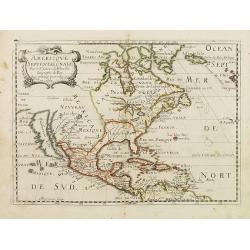
Americque Septentrionale. . .
A general map of North America shows California as an island but with few names and a flat northern coastline. Prepared by N. Sanson and engraved by A.Peyrounin. A first ...
- $1000 / ≈ €936
Place & Date: Paris, P. Marriete, 1667

Nova Virginia Tabula.
A beautifully engraved map, derived from the highly influential map by Captain John Smith in 1612, showing Chesapeake Bay and the surrounding area. The decoration of this...
- $1250 / ≈ €1170
Place & Date: Amsterdam, J.Meurs, 1671
![Noweav Mexiqve. [California as an Island]](/uploads/cache/26133-250x250.jpg)
Noweav Mexiqve. [California as an Island]
Scarce miniature map of California as a island, from Pierre Duval's La Geographie Universeille. The second earliest map to focus on just California and the contiguous coa...
- $800 / ≈ €749
Place & Date: Paris, 1672
Novi Belgii, quod nunc Novi Jorck vocatur, Novaeque Anglia et partis Virginiae. . .
A beautifully engraved map, derived from the highly influential map by Visscher. The decoration of this finely engraved map has in the lower right corner not longer a vie...
Place & Date: Amsterdam, 1673
Selling price: $1000
Sold in 2016

Pascaerte van Carybes, Nieu Neder landt, Brazil. . .
This progenitor chart covers the American shores of the Atlantic Ocean. This chart by Theunis Jacobsz. was most probably engraved close to his death in 1650 or shortly af...
- $2200 / ≈ €2059
Place & Date: Amsterdam, 1653-1681

P.les de Virginie.
Attractive copper engraving, depicting a couple of native people of Florida.From the French text edition of Description d'Univers, 1683. by Allain Manneson Mallet (1630-1...
- $110 / ≈ €103
Place & Date: Paris, 1683

Novi Belgii novae que Angliae nec non partis Virginiae..
The third state with Fort Kassimier and Philadelphia and nearby placenames added. To the south the Dutch colony of Nieu Amstel. New nomenclature and a key appear around t...
Place & Date: Amsterdam, 1684
![Amerique Septentrionale divisée en ses principales parties. . .1685. [California as an Island]](/uploads/cache/60628-250x250.jpg)
Amerique Septentrionale divisée en ses principales parties. . .1685. [California as an Island]
Engraved by Cordier. Spectacular example of Jaillot's map of North America, showing California as an Island, based upon Sanson's landmark map of 1656. This map shows the ...
Place & Date: Paris, 1685
![Amerique Septentrionale divisée en ses principales parties. . .1692. [California as an Island]](/uploads/cache/27961-250x250.jpg)
Amerique Septentrionale divisée en ses principales parties. . .1692. [California as an Island]
A very good impression of Jaillot's large map of North America, showing California as an Island, based upon Sanson's landmark map of 1656. A first state.The map shows the...
Place & Date: Amsterdam, c.1692

Belgii novi, angliae novae, et partis Virginiae . . .
This example is state 3 of the original Janssonius plate, printed after Schenk acquired the plates at public auction in 1694 from the heirs of Jansson van Waesberge. The ...
Place & Date: Amsterdam, 1694

Amerique Septentrionalis..
A handsome map showing California as an island, open-ended Great Lakes and other details based mainly on Sanson. A large decorative cartouche occupies the area of the nor...
Place & Date: Paris, after1694
Two polar calottes from a globe.
Two polar calottes from 110 centimeters in diameter globe of 1688 including the northern part of Baffin Bay, Greenland, Iceland, Nova Zembla. Coronelli elected to follow ...
Place & Date: Venice, 1696

L'Amerique Septentrionale.
Very rare map, from "Metaphaste Barbao, Descriptio Indiae Occidentalis et America Nova" published by Henrico Verdussen.The map is a copy of Guillaume de L'Isle'...
- $1250 / ≈ €1170
Place & Date: Antwerp, 1702