Browse Listings in America > Central America
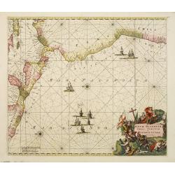
Nova Hispaniae, Chili, Peruviae, et Guatimalae Littorae..
A superbly decorative chart, oriented with north to the left of the sheet, covering the coasts of Central America, Peru, Chile, Jamaica and part of Cuba and Porto Rico. S...
- $1000 / ≈ €936
Place & Date: Amsterdam, 1660
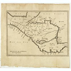
Descripcion del audiencia de Guatimala 6
The earliest map to include information from the previously secret manuscript maps of the Spanish cosmographer, Juan López de Velasco, showing part of Central America, i...
- $400 / ≈ €374
Place & Date: Amsterdam, Michel Colin, 1622
![[Indian caciques are held for ransom.]](/uploads/cache/40360-250x250.jpg)
[Indian caciques are held for ransom.]
Gutierrez held the Indian caciques ransom. He said they would be released in exchange for enough gold to fill a basket six times over. Later, some of the Indians bought g...
- $100 / ≈ €94
Place & Date: Frankfurt, M.Merian, 1633
![[Nicaraguan's dancing.]](/uploads/cache/40361-250x250.jpg)
[Nicaraguan's dancing.]
Each province organized its own festivities and people would come to a place of open land therein, which had been swept clean for dancing. The dancers were accompanied by...
- $100 / ≈ €94
Place & Date: Frankfurt, M.Merian, 1633
![[Natives of America offering Vaso Balbao gold.]](/uploads/cache/40362-250x250.jpg)
[Natives of America offering Vaso Balbao gold.]
This early engraving shows natives of America offering Vaso Balbao gold. In 1511, Nuñez de Balboa formed a colony on the banks of the Atrato, in the Gulf of Uraba. Two y...
- $100 / ≈ €94
Place & Date: Frankfurt, M.Merian, 1633
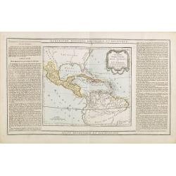
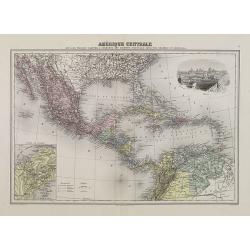
Guayane, Terre Ferme Isles Antilles. . .
Map showing Mexico, Cuba, Central America. Left and right a box with geographical information for each part country on the continent.Prepared by Louis Brion de la Tour an...
- $200 / ≈ €187
Place & Date: Paris, 1790
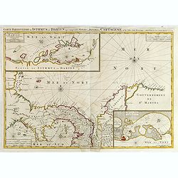
Carte Particuliere de Isthmus ou Darien qui Comprend le Golfe de Panama &c. Cartagena, et les Isles aux Environs.
Finely executed map of a portion of Central America, extending from the East Coast of Nicaragua and Costa Rica in the northwest to Cartagena and Santa Martha in modern Co...
- $1250 / ≈ €1170
Place & Date: Amsterdam, 1720
L'Ancien et le nouveau Mexique avec la Floride..
Covering Florida, Texas, western part of Cuba and central America. Showing dozens (100+) of place names, extensive river systems, mountain ranges and featuring the Gulf o...
Place & Date: Paris, 1781
![[How the Indians cured the Spanish thirst for gold....by pouring it down their throats!]](/uploads/cache/40483-250x250.jpg)
[How the Indians cured the Spanish thirst for gold....by pouring it down their throats!]
A brutal scene depicting native Indians tying down Spanish men and pouring liquid gold down their throats. Scenes of cannibalism in the background.In 1631 Johann Ludwig G...
Place & Date: Frankfurt, M.Merian, 1633
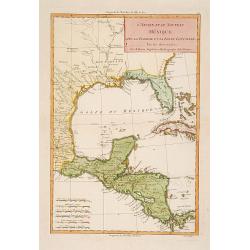
Le Indie Ocidentali ( Antille maggiori e minori, ecc) L'America Centrale . . .
Uncommon map of Central America and the Antilles prepared by Francesco Costantino Marmocchi. Above the map "Geografia Commerciale". From "Il Globo Atlante ...
Place & Date: Genova, Paolo Rivara fu Giacomo, 1858
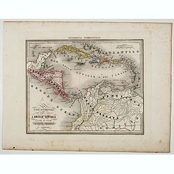
Amérique Centrale.
Decorative map of Central America from Géographie Universelle, Atlas Migeon. With an inset map of the Isthmus of Panama lower left corner and a panoramic view of Mexico ...
Place & Date: Paris, 1874

Yucatan . . . Et Guatimala Conventus Iuridicus.
Very attractive map encompassing the Mexican heartland, the Yucatan peninsula, and the old Spanish Audiencia of Guatemala including Honduras, Nicaragua, Costa Rica and pa...
Place & Date: Amsterdam, 1673
![[The dogs of Vasco Nunez de Balboa attacking native Indians]](/uploads/cache/40484-250x250.jpg)
[The dogs of Vasco Nunez de Balboa attacking native Indians]
A brutal scene in which the dogs of the Spanish explorer Vasco Nunez de Balboa, ferociously attack native Indians, while the Spanish look on.In 1631 Johann Ludwig Gottfri...
Place & Date: Frankfurt, M.Merian, 1633
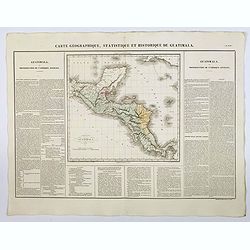
Carte Geographique, Statistique et Historique de Guatimala.
A nice detailed map of Guatemala from Buchon's Atlas Gégraphique Statistique, historique et chronologique des deux Ameriques et des isles adjacentes traduit de l'atlas e...
Place & Date: Paris, 1825