Browse Listings

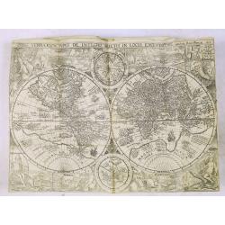
Peregrinations divi Pauli Tyrus Corographicus. . .
A beautifully executed and very rare map showing the peregrinations of St. Paul in the Eastern Mediterranean. The Mediterranean is ornated with two ships and two sea mons...
Place & Date: Paris, ca. 1640

Tableau des guerres de Frédéric le Grand: ou plans figurés de vingt-six batailles rangées, ou combats essentiels donnés dans les trois guerres de Silésie. . .
The book includes a large folded map "Tableaux des Guerres de Frédéric le Grand", showing a map of Prussia, with present-day Poland and Eastern Germany surrou...
Place & Date: Potzdam, Strasbourg, Paris, 1788

Campagne du Roi de Prusse de 1778 à 1779.
The book is illustrated with a two-sheet folding map "Carte d'une partie du Royaume de Bohême et de la Moravie ainsi que d'une partie de la Silésie". Prepared...
Place & Date: Geneva, Paris, Mérigot le jeune, 1784
![Carte de la coste orientale de la Chine depuis Amoy, jusqu'à Chusan avec une partie de l'Isle Formose [with] Plan du port d'Amoy ou Emouy.](/uploads/cache/33583-250x250.jpg)
Carte de la coste orientale de la Chine depuis Amoy, jusqu'à Chusan avec une partie de l'Isle Formose [with] Plan du port d'Amoy ou Emouy.
Important French chart of the China Sea with the coast of Northern China, including a large depiction of Formosa.Latitude and longitude scales, compass rose and system of...
Place & Date: Paris, Jean-François Robustel, 1745

Plan du Cap de Bonne-Esperance et ses environs..
Large and detailed sea chart of the Cape of Good Hope from Saldahna Bay to False Bay.Engraved by Guillaume-Nicolas Delahaye (1727-1802).Latitude and longitude scales, com...
Place & Date: Paris, 1745

Carte particulière de la côte d'Afrique depuis le cap des Courans jusqu'à la baye de Ste Hélène. . .
Large and detailed sea chart of South Africa.Engraved by Guillaume-Nicolas Delahaye (1727-1802).Latitude and longitude scales, compass rose and system of rhumb lines, sou...
Place & Date: Paris, 1745

Histoire de la Guerre Civile en Amerique par M. Le Comte de Paris, Ancien Aide de Camp du General Mac Clellan (McClellan). ...
These 30 maps were made by Vorzet to accompany Louis Phillipe d'Orleans' (Comte de Paris) multi volume "Histoire de la Guerre Civile en Amérique". The set incl...
Place & Date: Paris. Michel Levy Freres, 1875
![[Manuscript chart on vellum of the Java Sea]](/uploads/cache/33613-250x250.jpg)
[Manuscript chart on vellum of the Java Sea]
One of the few manuscript charts on vellum in private hands, signed by Isaac de Graaf. ORIGINAL MANUSCRIPT MAP IN RED, GREEN AND BLACK INK showing the Java Sea centered o...
Place & Date: Amsterdam, 1743

Tabula Prima Africa.
The map apart from depicting Morocco also shows southern Spain and the Balearic Islands. In north Africa the map extends eastwards toward modern day Algeria and to the we...
Place & Date: Strasbourg, 1513
![CH'ONHA CHIDO [Atlas of all under Heaven]](/uploads/cache/33625-250x250.jpg)
CH'ONHA CHIDO [Atlas of all under Heaven]
The Ch’onha chido [Atlas of all under Heaven] is a late 18th century copy of the traditional Korean atlas produced in the early Choson dynasty (1392-1910). One of the m...
Place & Date: Korea, ca. 1790

Karte von Europa im Jahre 1870 nach einem französischen Holzschnitte.
Satirical illustration by Paul Hadol showing disposition of power in Europe at the beginning of 1870. Satirical print depicting a map of Europe in which the countries are...
Place & Date: Hamburg, Fuchs, 1914
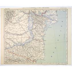
Carte de la Roumanie et Pays limitrophes. Odessa. GALATZ.
Very detailed (1:750.000) map centered on Constanta, with the river Danube in Romania. Made after an Austrian map. The French Service géographique des armées was founde...
Place & Date: Paris, 1908
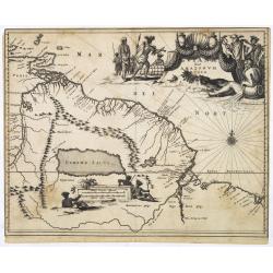
Guiana sive Amazonum Regio.
Map of Guiana and Amazon extending westwards to Trinidad and Margarita Island, dominated by a huge inland sea north of the Amazon.Embellished with decorative title and sc...
Place & Date: Amsterdam, 1673

Yucatan . . . Et Guatimala Conventus Iuridicus.
Very attractive map encompassing the Mexican heartland, the Yucatan peninsula, and the old Spanish Audiencia of Guatemala including Honduras, Nicaragua, Costa Rica and pa...
Place & Date: Amsterdam, 1673
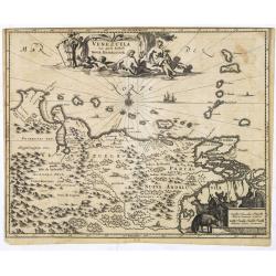
Venezuela cum parte Australi Novae Andalusiae.
Most decorative map with two large cartouches and compass-rose, large group of islands at the mouth of the Orinoco, other islands off Venezuela coast: Margarita, Aruba, C...
Place & Date: Amsterdam, 1673
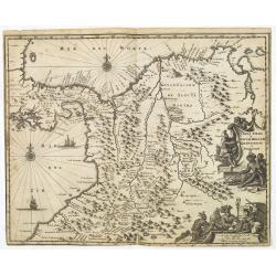
Terra Firma et Novum Regnum Granatense et Popayan.
Detailed map of Panama and northwestern South America derived from the Blaeu/Jansson map of the regionFeaturing ships at sea, two compass roses, and two cartouches depict...
Place & Date: Amsterdam, 1673

Brasila.
Map of Brazil extending from C. Nasou and Parime Lago to the Mouth of the Rio de la Plata. Oriented with West on top.The cartography of the region is quite primitive. The...
Place & Date: Amsterdam, 1673

.Paskaart van de Mont van de Witte Zee,. Beginnende van Tiepena tot Pelitza, als mede van C. Cindenoes tot Catsnoes.
Fine sea chart of the southern part of the Barents Sea, oriented to the West. With five inset maps: - Swetenoes, de Kust van Laplandt, Lombascho, 'T Vaste Landt van Lapla...
Place & Date: Amsterdam, c.1710

Partie de la Chine. N°.74 (Including South Korea)
Covering the Mouth of the Yangtze area in Jiangsu and Zhejiang, and southwestern Korea with the island of Quelpart (Jeju-do). Shows explorers' routes, including La Perou...
Place & Date: Brussels, 1825-1827

Partie de la Chine N°87. (Covers Jiangxi, Fujian and parts of Zhejiang, Guangdong, Hunan and Hubei.)
Covers Jiangxi, Fujian and parts of Zhejiang, Guangdong, Hunan and Hubei.From his famous Atlas Universel . This atlas was one of the most remarkable world atlases ever pr...
Place & Date: Brussels, 1825-1827

Partie de la Chine N°86. (Covers Guizhou and parts of Yunnan, Guangxi, Hunan, Hubei and Sichuan.)
Covers Guizhou and parts of Yunnan, Guangxi, Hunan, Hubei and Sichuan.From his famous Atlas Universel . This atlas was one of the most remarkable world atlases ever produ...
Place & Date: Brussels, 1825-1827

Potentissimo Borussorum Regi Friderico Wilhelmo Maiestate, Fortitudine Clementia Augustissimo Hancce Lithuaniam Borussicam : in qua luca coloniis Salisburg., ad incolendum Regio nutu...
Potentissimo Borussorum Regi Friderico Wilhelmo Maiestate, Fortitudine Clementia Augustissimo Hancce Lithuaniam Borussicam : in qua luca coloniis Salisburg., ad incolendu...
Place & Date: Nuremberg, 1735

Tabula Secunda Europe (Spain & Portugal)
Wood block printed large-format Ptolemaic map of the Iberian Peninsula from the 1513 edition of Waldseemüller's Geographia.This Ptolemaic map comes from the first so cal...
Place & Date: Strasburg, 1513

Karte von dem groessten Theil des Landes Jemen Imame, Kaukeban &c.
Large map of Yemen from "Allgemeiner grosser Atlas" published by P. J. Schalbacher - 1786-1800. Based on the observations of the Danish explorer Carsten Niebuhr...
Place & Date: Vienna, 1789

Carte von West=Gallizien welche auf allerhöchsten Befehl Seiner Kaiserlich oesterreichischen und Königlich apostolischen Majestät in den Jahren 1801 bis 1804. . .
Important early map of Western Galicia, as given to Austria by the third Partition of Poland (1795). Due to its long development period, a rare map rich in detail shows t...
Place & Date: Vienna, (1808) after 1811
![[Taprobana - Sri Lanka]](/uploads/cache/33847-250x250.jpg)
[Taprobana - Sri Lanka]
Wood block printed map and one of earliest printed representation of Ceylon prepared Martin Waldseemüller.Based on the slightly larger map from 1513 published in "P...
Place & Date: Vienna, Trechsel, G., 1525 -1541
![.[Pakistan, Afghanistan]](/uploads/cache/33849-250x250.jpg)
.[Pakistan, Afghanistan]
Wood block printed Ptolemaic map of the region of present-day Pakistan and part of Afghanistan. Convoluted mountain ranges and river systems dominate the trapezoidal map....
Place & Date: Vienna, Trechsel, G., 1525 -1541
![[Europe, Eastern, Sarmatia, Ukraine]](/uploads/cache/33854-250x250.jpg)
[Europe, Eastern, Sarmatia, Ukraine]
Wood block printed map and one of earliest printed representation of Europe, Eastern, Sarmatia, Ukraine prepared L. Fries after Martin Waldseemüller.Based on the slightl...
Place & Date: Vienna, Trechsel, G., 1525 -1541
![.[Italy]](/uploads/cache/33856-250x250.jpg)
.[Italy]
Wood block printed map and one of earliest printed representation of Italy prepared by Martin Waldseemüller. Based on the slightly larger map from 1513 published in &q...
Place & Date: Vienna, Trechsel, G., 1525 -1541
![.[Near east with Cyprus]](/uploads/cache/33857-250x250.jpg)
.[Near east with Cyprus]
Wood block printed map and one of earliest printed representation of Near east with Cyprus prepared by Martin Waldseemüller. Based on the slightly larger map from 1513 p...
Place & Date: Vienna, 1525 -1541
![.[Balkan region with Austria, Croatia, Slovenia, Switzerland, etc]](/uploads/cache/33858-250x250.jpg)
.[Balkan region with Austria, Croatia, Slovenia, Switzerland, etc]
Wood block printed map and one of earliest printed representation of Balkan with Austria, Croatia, Slovenia, Switzerland, etc prepared Martin Waldseemüller. Based on the...
Place & Date: Vienna, 1525 -1541
![.[India]](/uploads/cache/33861-250x250.jpg)
.[India]
Wood block printed map and one of earliest printed representation of India prepared by Martin Waldseemüller. Based on the slightly larger map from 1513 published in &quo...
Place & Date: Vienna, Trechsel, G., 1525 -1541
![.[Germany and Poland]](/uploads/cache/33862-250x250.jpg)
.[Germany and Poland]
Wood block printed map and one of earliest printed representation of Germany, Poland, The Low Countries, Austria and Switzerland prepared by Martin Waldseemüller. Based ...
Place & Date: Vienna, Trechsel, G., 1525 -1541
![.[Bangladesh, Burma, India, Thailand]](/uploads/cache/33867-250x250.jpg)
.[Bangladesh, Burma, India, Thailand]
Wood block printed map and one of earliest printed representation of Bangladesh, Burma, India, Thailand prepared Martin Waldseemüller. Based on the slightly larger map f...
Place & Date: Vienna, Trechsel, G., 1525 -1541
![[Albania, Bulgaria, Europe, Eastern, Greece, Hungary, Macedonia, Romania]](/uploads/cache/33868-250x250.jpg)
[Albania, Bulgaria, Europe, Eastern, Greece, Hungary, Macedonia, Romania]
Wood block printed map and one of earliest printed representation of Albania, Bulgaria, Europe, Eastern, Greece, Hungary, Macedonia, Romania prepared Martin Waldseemülle...
Place & Date: Vienna, Trechsel, G., 1525 -1541
![.[Georgia (Republic), Sarmatia, Ukraine]](/uploads/cache/33870-250x250.jpg)
.[Georgia (Republic), Sarmatia, Ukraine]
Wood block printed map and one of earliest printed representation of Georgia (Republic), Sarmatia, Ukraine prepared by Martin Waldseemüller. Based on the slightly larger...
Place & Date: Vienna, Trechsel, G., 1525 -1541
![[East Asia]](/uploads/cache/33873-250x250.jpg)
[East Asia]
Wood block printed map and one of earliest printed representation of East Asia and centered on Amenia, prepared Martin Waldseemüller. Based on the slightly larger map fr...
Place & Date: Vienna, 1525 -1541
![[India and China]](/uploads/cache/33875-250x250.jpg)
[India and China]
Wood block printed map and one of earliest printed representation of India and China prepared Martin Waldseemüller. Based on the slightly larger map from 1513 published ...
Place & Date: Vienna, 1525 -1541

Maris Pacifici.
From the rare Dutch text edition of the Theatrum of which according to van den Broecke only 100 copies are printed.This was the first printed map to be devoted solely to ...
Place & Date: Antwerp, 1598
Histoire de la Navigation.
A fine example of Linschoten's classic illustrated travelogue to the East and West Indies, termed by Lach “the most important of the firsthand accounts published indepe...
Place & Date: Amsterdam, Evert Cloppenburgh, 1638

Het gezandtschap der Neerlandtsche Oost-Indische Compagnie, aan den grooten Tartarischen Cham, Den tegenwoordigen Keizer van China. . .
Third edition of this beautifully illustrated work on China. The first edition was published in 1665.Jan Nieuhof was a "Dutch traveler and adventurer" (1618-72)...
Place & Date: Amsterdam, W. Waasberge, 1693

Vue de Malthe du cote du Fort.
A so-called optical print of Valletta seen from the castle. This rare optical print shows people in typical French dresses in the foreground and placed in boats.In the ei...
Place & Date: Paris, 1798
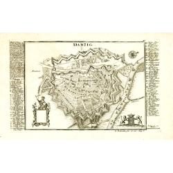
Danzig.
Detailed and rare plan of Danzig with extensive key in German.
Place & Date: Augsburg, 1730

Russie Européenne . . .
Detailed map of European part of Russia, including Finland and Lapland.Gilles Robert de Vaugondy (1688–1766), also known as Le Sieur or Monsieur Robert, and his son, Di...
Place & Date: Paris, ca. 1753

Carta geographica generalatus carlostatuensiscum adgacentibus confinis turcicis et venetis...
Fine and rare manuscript map of Croatia and the Dalmatian coast from the early eighteenth century. Oriented to the south the map details the Venetian, Austrian and Turkis...
Place & Date: Venice ?, c. 1700

Hark ! Hark ! The dogs do bark.
This very rare political caricature map of Europe depicts the continent at the outbreak of World War I, or as it was called at the time the Great War. Designed by Johnson...
Place & Date: London, Johnson Riddle & Co., 1914

Mapa De la parte de la Isla Formosa sa perteneciente al Emperadotde la China sacado por Ord. De S.M.
Extremely rare map of the west coast of Taiwan, the Punghu or Pescadore Islands, and the Fokien or Fujian coast of China. Several ancient Taiwanese cities are noted, incl...
Place & Date: Manilla, Seminario Conciliar, y Real de San Carlos, 1788-1792

Occidentalis Americae partis.
The most beautifully engraved early map of the Caribbean, including Florida and the Southeast. The map includes representations of Columbus' ships and various notes regar...
Place & Date: Frankfurt, 1594

Virginie, Grande Region l'Amerique Septentrionale...
Pierre van der Aa used the old copper plate of Meurs and re-did the engraving, changed the large pictorial cartouche, a new scale of German and French leagues is provided...
Place & Date: Amsterdam, 1729

Xantung, sinarum imperii provincia quatra.
A map of the northern province ‘Xantung’ of China after the Jesuit Martino Martini.Shows the Great Wall and is centered on the Bohai Sea, and the Shandong and Liaonin...
Place & Date: Amsterdam, ca 1660

Polonia regnum et Silesia ducatus.
Very decorative map of Poland embellished with two cartouches and two coats of arms surmounted by cherubs and female figures. Showing the region from the Oder east to Pod...
Place & Date: Amsterdam, 1638

Costumes des habitans de Manille.
A very beautiful print, showing four elegant figures relaxing in a shady glade, two women recline and two stand chatting.After a design of Duché de Vancy and engraved by...
Place & Date: Paris, 1798

Vue de cavite dans la Baie de Manille.
Two boats and passengers with Cavite Philippines in the background as if was seen from Manila Bay in January 1787. After a design of Gaspard Duchè de Vancy and engraved ...
Place & Date: Paris, 1798

(Untitled view from Scutari with a view of Constantinople)
Panoramic view from Scutari with a view of Constantinople in the distance, after a design by Johann Schranz. Published by J. Missiriè.
Place & Date: Paris, 1860

Die Stadt Narva. . .
An early of the town of Narva, located at the eastern tip of Estonia, on the Russian border.From the uncommon Hamburg edition "Viel Vermehrte Moscowitische und Pers...
Place & Date: Hamburg, 1696

Map of China.
Showing China, Taiwan and Korea, divided into provinces with the main cities marked. The map is of interest for the use of Sea of Corea, the sea between Korea and Japan, ...
Place & Date: London, 1804

Allegory of geography.
Two putty studying a terrestrial globe, one of them holding a pair of dividers. The information on the globe is clearly imaginary but the two cartouches and ships are typ...
Place & Date: Bruges, ca. 1700
![Morokoshi Meisho Zue [Illustrated Description of Famous Sites of China].](/uploads/cache/34118-250x250.jpg)
Morokoshi Meisho Zue [Illustrated Description of Famous Sites of China].
Published in Osaka, Kawachiya Genhichiro, et al. [8 book sellers], slightly later issue but apparently in Edo period, using all the same woodblocks of original first edit...
Place & Date: Osaka, Edo, slightly later than Bunka 3, year of the tiger - 1806

Le globe terrestre representé en deux plans-hemispheres, Dressé sur la Projection de Mr. De la Hyre...
“This splendid GlobeTerrestre originally published by J.B. Nolin is one of the finest large-scale world maps to be produced and is a fitting bridge between the geograph...
Place & Date: Paris, c. 1780

Carta Topografica dell' Isola Del Maritaggio di Monsieur le Boble per la prima volta. Tradotta dal francese in italiano.
Second Italian printing of Eustache Le Noble’s "Carte de l’isle de marriage." The book’s text offers instructions on how to reach this matrimonial island ...
Place & Date: Cosmopoli, 1766

A unique composite atlas with updated Porro maps.
Unique composite atlas containing in total 84 maps - 82 maps engraved by Girolamo Porro and heavenly reworked around 1686 and 2 newly engraved maps; Piccola Tartaria (Cr...
Place & Date: Venice, 1686

A Map of the Environs of Constantinople Drawn from a great number of accurate astronomical & geographical manuscripts and printed documents, by A. Arrowsmith 1801 and 1804.
Arrowsmith’s large and detailed map of the Ottoman Empire and the Black Sea, with Cyprus, Crete and the Greek Islands in the Mediterranean Sea, Albania, Bosnia and Herz...
Place & Date: London, No.10 Soho Square, 4th September 1804
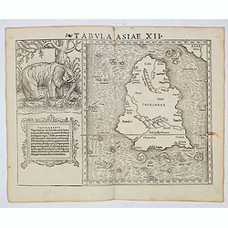
Tabula Asiae XII (Sri Lanka, with Elephant)
The FIRST edition of Munster's first modern map of Sri Lanka, which appeared in his "Geographia Universalis", first published in 1540. The Geographia was a new ...
Place & Date: Basel, Heinrich Petri, 1545

Carte du Katay ou Empire de Kin. . .
The map is of interest for the use of Mer de Corée for the sea between Korea and Japan .Fine map of Korea and China's Yellow Sea. Complete title in top: Carte du Katay o...
Place & Date: Paris, 1750

Carte de L'Empire d'Alemagne par P. Duval. . .
Uncommon map of Germany and the eastern part of Poland. In upper right corner a dedicational cartouche with coat of arms and dedication to Saint-Laurens.
Place & Date: Paris, 1676

Plan de la rade de Macao (chine) Levé d'après les ordres mr. Rocquemaurel.
Very detailed chart of Macao and several of the surrounding Islands, and features numerous depth soundings throughout. Prepared by captain, Gaston de Rocquemaurel. Logo o...
Place & Date: Paris, c.1856 / 1863

Mufle de veau. Antirrhinum majus L.
Bouquet of Common Snapdragons, engraving by P.F. Le Grand after designs by the Dutch born Gerard van Spaendonck (1746-1822).Taken from the rare work "Fleurs dessiné...
Place & Date: Paris, c.1800

Digitale pourprée. Digitalis purpurea L.
The foxglove, engraving by P.F. Le Grand after designs by the Dutch born Gerard van Spaendonck (1746-1822).Taken from the rare work "Fleurs dessinées d'après natur...
Place & Date: Paris, c.1800
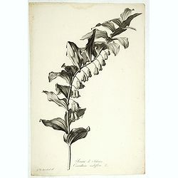
Sceau de Salomon. Convallaria multiflora L.
King Solomon's Seal or David's Harp, engraving by P.F. Le Grand after designs by the Dutch born Gerard van Spaendonck (1746-1822).Taken from the rare work "Fleurs de...
Place & Date: Paris, c.1800

Grande Capucine. Tropaeolum majus. L.
Indian cress or monks cress, engraving by P.F. Le Grand after designs by the Dutch born Gerard van Spaendonck (1746-1822).Taken from the rare work "Fleurs dessinées...
Place & Date: Paris, c.1800
![[Set of 6 maps] Charta öfver Storfurstendömet Finland på Friherre S. G. Hermelins Anstalt och Omkostnad. Sammandragen och författad af C. P. Hällström. Philos. Magister och Auscultant i Kongl. BergsColl. 1799.](/uploads/cache/34482-250x250.jpg)
[Set of 6 maps] Charta öfver Storfurstendömet Finland på Friherre S. G. Hermelins Anstalt och Omkostnad. Sammandragen och författad af C. P. Hällström. Philos. Magister och Auscultant i Kongl. BergsColl. 1799.
This is the beautiful set of key map and separate maps of Samuel Gustav Hermelins map of Finland. The maps have been engraved by Fredrik Akrel, a very skilled and product...
Place & Date: Källa: J.Strang & E.- S. Harju: Suomen karttakirja 1799

The Crimea, chiefly from surveys made by order of the Russian government. . .
Map of Crimea and the Sea of Azov. In lower right corner two inset maps showing Sebastopol inlet and harbour and a second one with the Black Sea. This second maps shows t...
Place & Date: London, 1854

Tabula Anemographica seu Pyxis Nautica.
Impressive compass rose with a fleur de lis at the center and 32 wind directions flowing from it identified in six languages, Greek, Latin, French, Dutch, Italian, and Sp...
Place & Date: Amsterdam, 1650

Pascaerte van 't Westelyckste Deel van Oost Indien, van Cabo de Bona Esperanca tot C.Comorin..
An eye-catching chart of the western part of the Indian Ocean and its adjacent coasts of East Africa, Arabia with the Red Sea and the Arabian Gulf, Iran, Pakistan and we...
Place & Date: Amsterdam, 1666

Loudunois. Laudunum / Mirebalais.
Two maps on one sheet. Centered on Loudun and Mirebeau. Showing lower left cartouche putti playing with grapes.German text on verso.
Place & Date: Amsterdam, after 1636

Pascaart van Europa alsmede een gedeelte vande Kust van Africa. . .
An eye-catching chart of the entirety of Europe's coastline from northern Russia to Yugoslavia in the south. Also showing the West Coast of Africa as far as the Cape-Verd...
Place & Date: Amsterdam, after 1666
Selling price: $2375
Sold in 2023

A new & accurate map of Asia, Drawn from the most approved modern maps & charts / by Thos. Bowen.
The map is of interest for the use of Sea of Korea, the sea between Korea and Japan.Detailed map of Asia from Saudi Arabia, Persia, Russia, India, China, Japan to Southea...
Place & Date: London, J.Cooke, 1777-1778
Selling price: $600
Sold in 2023

La China e Giapone.
Uncommon map of China, Korea, Japan and Taiwan (I.Formosa), only one town labeled, Tayoan. Very strange shape for Japan.The map is of interest for the use of Mar di Corea...
Place & Date: Italy, ca. 1800
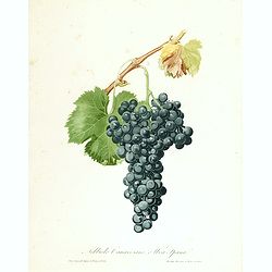
Nobiolo Canavesano, o uva Spanal.
Highly decorative stipple engraving with hand-colored details from a scarce work 'Pomona Italiana ossia Trattato Degli Alberi Fruttiferi' by Giorgio Gallesio. The series ...
Place & Date: Turin, 1832
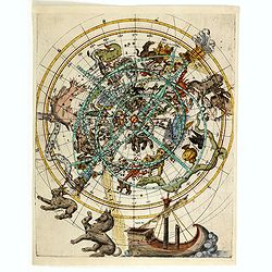
(Northern celestial planisphere with a pasted volvelle.)
Probably by the Vienna astronomer Melchior Klayber who used the Copernican precession theory, which is closely connected with the chart (Ptolemy - 6° 40' and Ptolemy - 5...
Place & Date: Vienna, ca. 1569