Browse Listings
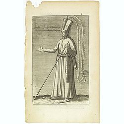
Habit et Manière ancienne des Peiches ou Laquais du Grand Seigneur. (14)
Sought-after copper engraved plate taken from Laonikos Chalcocondyle’s "L'histoire de la décadence de l'empire grec et establissement de celuy des Turcs." by...
Place & Date: Paris, Mathieu Guillemot, 1650
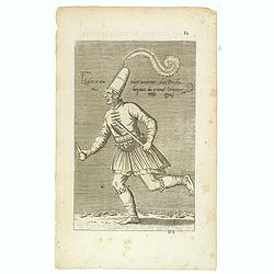
Iannissaire Allant à la Guerre. (9)
Sought-after copper engraved plate from Laonikos Chalcocondyle’s "L'histoire de la décadence de l'empire grec et establissement de celuy des Turcs." by Thoma...
Place & Date: Paris, Mathieu Guillemot, 1650

Mar del Zur, Hispanis Mare Pacificum.
Janssonius' fine chart of the Pacific including the west coast of America with California shown as an island, Japan and a small Australian coastline. This is the earliest...
Place & Date: Amsterdam, 1650
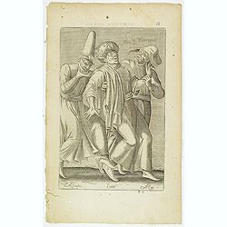
Les Yurongnes. (18)
Sought-after copper engraved plate taken from Laonikos Chalcocondyle’s "L'histoire de la décadence de l'empire grec et establissement de celuy des Turcs." by...
Place & Date: Paris, Mathieu Guillemot, 1650
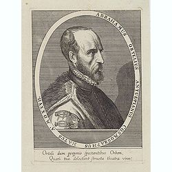
Abrahamus Ortelius Antuerpianus cosmographus natus a. MDXXVII
Portrait of Abraham Ortelius (Abraham Ortel), famous cartographer born in Antwerp and after studying Greek, Latin and mathematics set up a business there with his sister,...
Place & Date: Antwerp, c.1650
Selling price: $225
Sold in 2023
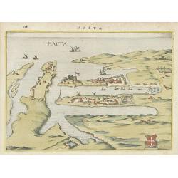
Malta.
Attractive birds-eye town-view of Valetta on Malta. With coat of arms lower right. With page number 398 in top. Latin text on verso.
Place & Date: The Netherlands ? 1650
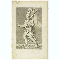
Iannissaire ou Ianissarler Soudart a Pied de la Garde Ordinaire du Grand Seigneur. (8)
Sought-after copper engraved plate from Laonikos Chalcocondyle’s "L'histoire de la décadence de l'empire grec et establissement de celuy des Turcs." by Thoma...
Place & Date: Paris, Mathieu Guillemot, 1650
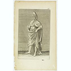
Torlaqui Religieux Turc. ( 25 )
Sought-after copper engraved plate taken from Laonikos Chalcocondyle’s "L'histoire de la décadence de l'empire grec et establissement de celuy des Turcs." by...
Place & Date: Paris, Mathieu Guillemot, 1650
(Grand dame Turque. 45)
Sought-after copper engraved plate of a woman from Turkey. Plate from Laonikos Chalcocondyle’s "L'histoire de la décadence de l'empire grec et establissement de c...
Place & Date: Paris, Mathieu Guillemot, 1650
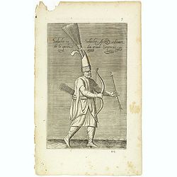
Solachi ou Solacler, Archer Ordinaire de la Garde du Grand Seigneur. (7)
Sought-after copper engraved plate taken from Laonikos Chalcocondyle’s "L'histoire de la décadence de l'empire grec et establissement de celuy des Turcs." by...
Place & Date: Paris, Mathieu Guillemot, 1650

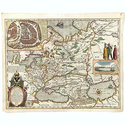
Hassia Landgraviatus.
Centered on the town of Kassel.
Place & Date: Amsterdam, 1650
![Bressia vulgo Bresse. [colored by Van Santen]](/uploads/cache/29235-250x250.jpg)
Bressia vulgo Bresse. [colored by Van Santen]
Title cartouche with putti and surveyor with surveying instruments. Upper right-hand corner Geneva, lower left Lyon and in the center Bourg-en Bresse. Upper right-hand co...
Place & Date: Amsterdam, 1650
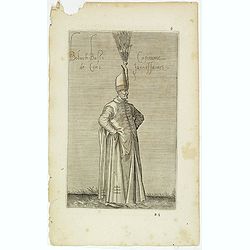
Boluch Bassi Capitaine de Cent Janissaires. (6)
Sought-after copper engraved plate from Laonikos Chalcocondyle’s "L'histoire de la décadence de l'empire grec et establissement de celuy des Turcs." by Thoma...
Place & Date: Paris, Mathieu Guillemot, 1650
Tabula Russiae.
A re-issue, by Willem Blaeu, of Hessel Gerritsz' rare and influential map of Russia. This fine map was compiled from manuscripts brought back from Russia, by Isaac Massa ...
Place & Date: Amsterdam, 1650
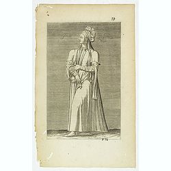
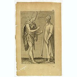
Femme Persienne. (59)
Sought-after copper engraved plate of a woman from Persia. Plate from Laonikos Chalcocondyle’s "L'histoire de la décadence de l'empire grec et establissement de c...
Place & Date: Paris, Mathieu Guillemot, 1650

Tabula Russiae.
One of the most decorative maps of Russia, based on the work of Fedor Borisovich. Visscher's version of Hessel Gerritsz' rare map of Russia. In an inset -130x170mm- a pla...
Place & Date: Amsterdam, 1651
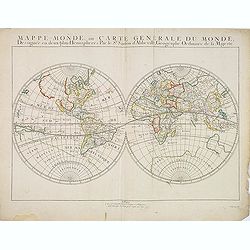
Mappe-Monde, ou Carte Generale du Monde: Dessignée en deux plans Hemispheres Par le Sr. Sanson d'Abbeville, Geographe ordinaire de sa Majesté.
Sanson's first world maps, dated 1651 and 1652, were issued separately and then in collections of mapsThe map is one of the first to distinguish the Great Lakes, all five...
Place & Date: Paris, 1651

Americae Nova Descriptio.
Final state. According to Philip Burden, "this scarce map is America's first single-sheet map with decorative borders." A re-issue of the 1614 plate by Pieter v...
Place & Date: Amsterdam, 1652

Carte des Trois Arabies. Tiree en Partie de l'Arabe de Nubie, en Partie de Divers autres Autheurs. . .
Rare map of the Arabian Peninsula, first published in 1654 and one of the first large maps focused specifically on the Arabian Peninsula. Sanson's map of the Arabian Peni...
Place & Date: Paris, 1654

Terra Promissions.
A beautifully executed and very rare map of the Promised Land, divided into the 12 Tribes. The shore line runs in north-southwesterly direction from Sidon as far as Pelus...
Place & Date: Paris, c.1655
-250x250.jpg)
Vues du port de Llivourne. (set of 6 prints)
Sought-after complete suite of 6 engravings by S[tefano] Della Bella [1610-1664]. in a second state (of 2).Della Bella was born in Florence in 1610, and studied the art ...
Place & Date: 1654-1655

Tweevoudigh onderwiis van de Hemelsche en Aerdsche Globen; Het een Na de meyning van Ptolemeus met een vasten Aerdkloot...
Tweevoudigh onderwiis van de Hemelsche en Aerdsche Globen; Het een Na de meyning van Ptolemeus met een vasten Aerdkloot; Het ander Na de Natuerlijcke stelling van N. Cope...
Place & Date: Amsterdam, 1655

Insulae de Cabo Verde olim Hesperides sive .. Zoute Eylanden.
Original copper engraving, hand colored in outline, when published. Double page chart covering detailed the Cap Verde Islands in the Atlantic Ocean (Isla de San Antonia, ...
Place & Date: Amsterdam, 1655

Moscovia urbs Metropolis totius Russiae Albae.
Detailed bird's-eye town-plan of Moscow from Janssonius' rare townbook. With a key (1-20) to important spots in town. The verso has French text and originates from Jansso...
Place & Date: Amsterdam, 1657
![Mexico, Regia et Celebris Hispaniae Novae Civitas ... [on sheet with] Cusco, Regni Peru in Novo Orbe Caput.](/uploads/cache/29013-250x250.jpg)
Mexico, Regia et Celebris Hispaniae Novae Civitas ... [on sheet with] Cusco, Regni Peru in Novo Orbe Caput.
Two bird's-eye views on one sheet: Mexico and Cusco.Showing Mexico City and Cusco, the capital cities of the Aztecs and Incas, with the major buildings shown in profile w...
Place & Date: Amsterdam, 1657

Les deux poles articque ou septentrional et antarticque..
A double hemisphere map to the North and South poles. The North pole is connected to Greenland and Spitzbergen but there is little other detailed coastline in the polar a...
Place & Date: Paris, 1657

Pascaerte van Brazil en Nieu Nederlandt van Cuorvo en Flores.
A rare chart of the Atlantic Ocean from the first edition of Hendrick Doncker's Zee-Atlas, of which no surviving example is known.Although the idea of its unusual coverag...
Place & Date: Amsterdam, 1658

Tabula Magellanica.
A map with Willem Blaeu's signature, but published by his son Joan, of South America's extremity with the Strait of Magellan and Le Maire Strait.The coastlines are depict...
Place & Date: Amsterdam, 1658

De Zype. / Purmer / Wormer/ Beemster / Waterland.
Five maps on one sheet. Showing the polders of De Zype, De Purmer, De Wormer, De Beemster and a map of Waterland, including de Bylmermeer and Monnekedam. Showing the Noor...
Place & Date: Amsterdam, 1652-1658

Insula Huaena sive Venusia a Guiljelmo Blaeu cum sub Tychone Astronomiae operam daret, delineata.
Decorative map of the island Hvan in the Danish Sound. In the center Tycho Brahe's famous observatory Uraniborg established in 1576, under the patronage of Frederick II, ...
Place & Date: Amsterdam, 1659

Pascaerte vande Caribische Eylanden, vande Barbados tot aende Bocht van Mexico ‘t Amsterdam By Hendrick Doncker. . .
First state. Rare. “This chart appeared in the first edition of Hendrick Doncker’s Zee-Atlas, of which no surviving example is known” -- Burden. This is an example ...
Place & Date: Amsterdam, 1659

Magnus Ducatus Finlandiae Auct. Andrea Bureo Succo.
The first printed survey map of Finland, composed by the Swedish cartographer Anders Bureus (1571-1661). The map was published in 1662 in the second volume of Joan Blaeu'...
Place & Date: Amsterdam, 1660

Xantung, sinarum imperii provincia quatra.
A map of the northern province ‘Xantung’ of China after the Jesuit Martino Martini.Shows the Great Wall and is centered on the Bohai Sea, and the Shandong and Liaonin...
Place & Date: Amsterdam, ca 1660

Xantung, sinarum imperii provincia quatra.
A map of the northern province ‘Xantung’ of China after the Jesuit Martino Martini.Shows the Great Wall and is centered on the Bohai Sea, and the Shandong and Liaonin...
Place & Date: Amsterdam, ca 1660

Nova Africa descriptio.
A beautifully engraved and most attractive "carte à figures"- map of the African continent. Bordered, above, by panels showing panorama's of Cairo, Alexandria,...
Place & Date: Amsterdam, after 1660

Pecheli, Xansi, Xantung, Honan, Nanking, In plaga Regni Sinensis. . .
A map of the northern provinces of China after the Jesuit Martino Martini, depicting of Hebei (Pecheli), Shanxi (Xansi), Shandong (Xantung), Henan (Honan), and Jangsu (Na...
Place & Date: Amsterdam, ca 1660

Hollandia Comitatus.
Orientated west to the top of the sheet, this presents the County of Holland in the classical orientation for seventeenth-century maps, with Amsterdam at the center. The ...
Place & Date: Amsterdam, 1660

Original copperplate.
Showing the coast of southern Morocco, the Sahara with the Canary Islands. Copperplates that had been used in the production of early maps are of the greatest rarity and ...
Place & Date: Amsterdam, ca. 1660
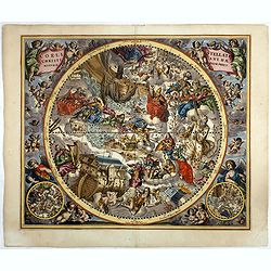
Coeli Stellati Christiani Haemisphaerium Prius.
Scarce first issue. This spectacular celestial chart presents the constellations according to Christian symbolism. The view of the constellations is based on the work of ...
Place & Date: Amsterdam, 1660
![Praga. [Prague]](/uploads/cache/28442-250x250.jpg)
Praga. [Prague]
A rare panoramic of Prague with over the whole length of the lower part 3 columns of poems in Latin, Dutch and French and a numbered key 1-34 to the principal buildings ...
Place & Date: Amsterdam, 1660