Browse Listings in Asia

Partie de la Chine N°86. (Covers Guizhou and parts of Yunnan, Guangxi, Hunan, Hubei and Sichuan.)
Covers Guizhou and parts of Yunnan, Guangxi, Hunan, Hubei and Sichuan.From his famous Atlas Universel . This atlas was one of the most remarkable world atlases ever produ...
Place & Date: Brussels, 1825-1827

Sincapour.
Early view of Singapore after Paris and engraved in aquatint technique by Sigismond Himely (1801-1872). Published as plate 28 in Voyage autour du monde par les mers de l'...
Place & Date: Paris, Finot, 1835

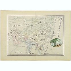
Siberia & Central Asia.
This map covers the eastern section of Russia as well as China, Japan, Korea, India and Tibet. The map is of interest for the use of Sea of Corea, the sea between Korea a...
Place & Date: Boston, 1835

Arabia. Sive Regio inter Mare Medium, Arabicum Sinum, . . .
Very detailed map of the Arabian Peninsular, covering the Caspian Sea in the upper right corner and Syria to the Indian Ocean, Somalia and parts of Persia, Syria and Kurd...
Place & Date: London, 1841

Arabia.
Steel engraved map of the Arabian Peninsular. It shows Arabia and Parts of Persia, Syria and Kurdistan. The regional boundaries are colored and relief shown by hachures. ...
Place & Date: London, 1841

Straat Riouw onder opzicht van de commissie tot verbetering der Indische Zeekaarten..
Very large and rare so-called Blue Back centered on the strait passing between the Riau Islands. It contains an inset map with enlarged details of Riouw Harbor on Bintang...
Place & Date: Amsterdam 1843
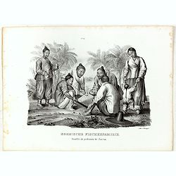
Koreische Fischerfamilie. Famille de pecheurs de Corea.
A Korean family of fishermen playing a board game. No.9' above image. From "Schinz Naturgeschichte und Abbildungen des Menschen der verschiedenen Rassen und Stämme&...
Place & Date: Zürich, 1845
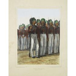
Infanterie Turque (chasseurs). 7 novembre 1837.
Beautiful lithography by Auguste Raffet (1804 -1860 ) and printed by Auguste Bry.
Place & Date: Paris, Gihaut frères, 1848

ARMENIEN. Costumes de l'Empire Ottoman 9.
A beautiful hand colored lithograph of an Armenian published in the French work "Galerie Royale de Costumes peints d´après nature par divers artistes et lithograph...
Place & Date: Paris, Chez Aubert & Cie., 1842-1848

AFGHAN de CABOULE. Costumes Persans 8.
A beautiful hand colored lithograph of an elegant Afghan from Kabul published in the French work "Galerie Royale de Costumes peints d´après nature par divers artis...
Place & Date: Paris, Chez Aubert & Cie., 1842-1848

DANSEUSE. Costumes Persans 9.
A beautiful hand colored lithograph of an elegant dancing girl from Persia published in the French work "Galerie Royale de Costumes peints d´après nature par diver...
Place & Date: Paris, Chez Aubert & Cie., 1842-1848

Kamchatka according to A.Erman . . .
FIRST EDITION Map of the Kamchatka Peninsula, Siberia, from Gazetteer of the World. Drawn by Augustus Petermann, engraved by G. H. Swanston.
Place & Date: London / Edinburgh, 1850

Plan de Constantinople, non compris ses faubourgs. Grave d'apres les documents du ministere de la Guerre par E. Olivier.
A very rare lithographic town-plan of Istanbul, Scale 98 yards to one inch., printed in Pera, Istanbul by E. Olivier. The ornate design on the top of the title is a tugh...
Place & Date: Péra, Istanbul, 1851

Simori.
Portrait of Simori.Von Siebold was born in Wurtzburg, in Germany, and worked for the Dutch government as a doctor in Java. In Japan, where Von Siebold arrived in 1823 at ...
Place & Date: Leiden, 1832-1852
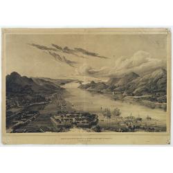
Gezigt op de haven en de baai van Nagasaki.
A very rare birds-eye view showing Deshima and Nagasaki bay. Von Siebold was born in Würtzburg, in Germany, and worked for the Dutch government as a doctor in Java. In J...
Place & Date: Leiden 1832-1852

Carte d'unne partie de l'Arabie Septentrionale Pour suivre les Voyages de Mr. G.A. Vallin. . .
This is the original hand-drawn map by Victor Adolphe Malte-Brun of "Carte d'unne partie de l'Arabie Septentrionale Pour suivre les Voyages de Mr. G.A. Wallin",...
Place & Date: Paris, November 1855

(Untitled view from Scutari with a view of Constantinople)
Panoramic view from Scutari with a view of Constantinople in the distance, after a design by Johann Schranz. Published by J. Missiriè.
Place & Date: Paris, 1860

A fan combining views of Hong Kong (right), Canton (center), and Macau.
The fan shows nice images of Macau, Hong Kong and Canton on onside and on verso a garden with 45 characters welcoming a rider on his white horse. Their clothes are height...
Place & Date: China, ca. 1850-1860

Plan de la rade de Macao (chine) Levé d'après les ordres mr. Rocquemaurel.
Very detailed chart of Macao and several of the surrounding Islands, and features numerous depth soundings throughout. Prepared by captain, Gaston de Rocquemaurel. Logo o...
Place & Date: Paris, c.1856 / 1863

NEWTON'S New and Improved TERRESTRIAL GLOBE Accurately delineated from the observations of the most esteemed NAVIGATORS AND TRAVELLERS to the Present Time. . .
A very impressive Victorian 20-inch Library globe showing the "Gulf of Corea". On an exceptionally carved mahogany tripod stand with scrolling acanthus legs ter...
Place & Date: London, January 1, 1867

Carte générale de L'Empire Ottoman en Europe et en Asie dressée par Henri Kiepert . . .
Large School wall map of Turkish Empire printed in chromo-lithography. Published by Dieter Reimer and printed by Ferdind Barth in Berlin. This rare map has two insets in ...
Place & Date: Berlin, Verlag von Dietrich Reimer, 1867

CARTE de la Côte Occidentale de COREE, Plan Croquis de la Rivière HAN-KANG ou de SEOUL, depuis son Embouchure jusqu'à Séoul, dressée en 1866 ...
Uncommon chart of the Han-Kang River from its mouth to Seoul, prepared in 1866 by order of C.A. ROZE, Commander-in-Chief of the French " la Station des Mers de Chine...
Place & Date: Paris, 1868
TYO SYEN Corée par les Missionnaires de Corée de la société des missions etrangéres.
A very nice map and rare map of Korea. Prepared by R.P.Carceri who was an missioner active for de la Sociéte des Missions Etrangères.Published as a supplement to Journa...
Place & Date: Lyon, 1872
Selling price: $700
Sold in 2023

Kiepert's Physikalische Wandkarten IV. ASIEN. . .
Wall map of Asia printed in chromo lithography. Published by "Stich und Druck der lith. Anst. Von Leopold Kraatz in Berlin". Physical map showing the Asian cont...
Place & Date: Berlin, D. Reimer, 1873

Mer de Chine - Detroit De Singapour Partie Comprise Entre Singaour et Le Dett. De Malacca d'apres les travaux du Commr. J.W. Reed de la Marine Royale d'Angleterr, ...
A detailed chart of Singapore Strait, drawn from an English Chart by J.W. Reed, who surveyed Singapore and environs between 1865 and 1869, aboard the H.M.S. Rifleman.The ...
Place & Date: Paris, 1873

Carte du Kouy-Tchéou.
Detailed map of Guizhou Province prepared by Mgr. Faurie and other sources supplied by missionaries. Published in "Les Missions Catholique". Engraved by P. Méa...
Place & Date: Lyon, c.1874
![Carte du Tche-Kiang. [ Zhejiang province ]](/uploads/cache/30921-250x250.jpg)
Carte du Tche-Kiang. [ Zhejiang province ]
Map of Tche Kiang, prepared by Bishop Edmond-François Guierry, C.M. (Vicar Apostolic of Zhejiang, China) after sources supplied by missionaries. Published in "Les M...
Place & Date: Paris, 1874

Un Reclutatore in India. Papagallo No. 42. Anno VI.
British in India. Design by Augusto Grossi. Taken from the Italian satirical newspaper Il Papagallo, a satirical magazine founded in January 1873 by Augusto Grossi (1835-...
Place & Date: Bologne, 1878
Asie.
Manuscript map made by miss Marie Demeule, dated Elbeuf 1879. Elbeuf is a town within the Upper Normandy region in France.In the 19th century many students, and quite oft...
Place & Date: France, Elbeuf, 1879
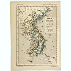
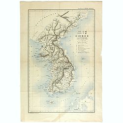
Carte de la Corée d'après la Carte du Dictionnaire coréen-français par les Missionnaires de Corée. . .
Map of Korea called "Corée", which was produced by the French organization Mission Etrangères de Paris (MEP) in 1880. Supposedly, the map was based on Father ...
Place & Date: Paris, 1880
![Hong Kong. [Queen's Road]](/uploads/cache/24362-250x250.jpg)
Hong Kong. [Queen's Road]
Finely executed watercolor made by Henri Dieth of a charming atmospheric street scene at Queen's Road in Hong Kong. The watercolor is made after Eduard Hildebrandt (1818-...
Place & Date: Germany, 1882
![Hongkong Piratenstrasse. [Pirate Street]](/uploads/cache/24363-250x250.jpg)
Hongkong Piratenstrasse. [Pirate Street]
Finely executed watercolor made by Henri Dieth of a charming street scene at "Pirate Street" in Hong Kong. The watercolor is made after Eduard Hildebrandt (1818...
Place & Date: Germany, 1882

Runde Strasse in Peking.
Finely executed water color made by Henri Dieth of a charming street scene in Peking. The water color is made after Eduard Hildebrandt (1818-1869). Hildebrandt, was born ...
Place & Date: Germany, 1882
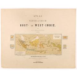
Overzichtskaart van den Nederlandsch oost Indischen Archipel.
Very detailed map of Indonesia, taken from "Atlas van Nederlandsch Oost- en West-Indie," prepared by a doctor I. Dornseiffen, and published by Seyffardt's Boekh...
Place & Date: Amsterdam, Seyffardt, 1884

Atlas des Missions de la Société des Missions-Étrangères. . .
This scarce atlas contains maps showing the locations of the Catholic missions belonging to the Société des Missions Étrangères in Asia. It covers India, Burma, Siam,...
Place & Date: Lille, 1890

Chosen Danpan - Korean negotiation.
A scene of a Japanese legation under the command of Hanabusa Yoshitada who is forcing the Korean King Kojong (1852-1919) to agree to Japanese demands during the Chemulpo ...
Place & Date: August 8, MEIJI 27th year or 1894

KOUSHI NYUJO no Zu - HANABUSA Legation enters in Palace, Seoul.
A scene of Japanese legation HANABUSA who are entering the Royal Palace, Seoul.
Place & Date: August 8, MEIJI 27th year or 1894
![Nankin [Nanjing, Jiangsu]](/uploads/cache/30031-250x250.jpg)
Nankin [Nanjing, Jiangsu]
Very detailed (1:1.000.000) map showing the area north of Nanjing, Jiangsu. The French Service géographique des armées was founded in 1887 and provided the French milit...
Place & Date: Paris, 1900

COLLECTION OF HONG KONG MAPS, BOOKS & FLYERS. Including CHINA - HONGKONG surveyed by Captn. Sir Edward Belcher, in H.M.S. Sulphur 1841. Corrected to 1901.
A collection of 30 maps, prints, and publications relating to Hong Kong. Including : - BELCHER, E. Sir, An updated version of this most important nautical chart of Hong K...
Place & Date: London, 1841 - 1901

CANTON Kong-Teheou.
Very detailed (1:1.000.000) map centered on Macao and Victoria Island, showing soundings, English, Australian, Danish telegraph lines reaching Hong Kong and extended to M...
Place & Date: Paris, 1898 updated for june 1904