Browse Listings in America

Paraquariae Provinciae Soc. Iesu cum Adjacentibus Novissima...
Between the years of 1609 and 1780, the Jesuits (the Roman Catholic Society of Jesus) established in South America, an autonomous Christian state, on the lands of present...
Place & Date: Augsburg, 1740

Carte des Iles Hawaii.
A lovely small map of the complete chain of Pacific islands known today as the Hawaiian islands, from Dumont d'Urville's atlas "Voyage pittoresque autour du Monde.&q...
Place & Date: Paris, 1834

Carte des Isles d'Acores.
Uncommon and detailed map of the Azores. With inset maps of Port de St.Cruz and harbor and town of Angra on the island of Terceira. It was at the time an important port a...
Place & Date: Amsterdam, 1730

Stoel des Oorlogs in America Waar in Vertoont Werden Alle Desself Voornaamste Eylande . . .
Large impressive map of the West Indies with the Gulf of Mexico and Florida. The map shows prominently in the center Cuba, Haiti, the Bahamas and Florida, which is here m...
Place & Date: Amsterdam, c. 1720

A-Na-Cam-E-Gish-Ca. A Chippeway Chief.
Half-length portrait of Anacamegishca, bare-chested, wearing a blanket and a peace medal. A-Na-Cam-E-Gish-Ca (1785-1862) - was a Chippeway Indian Chief. The Chippewa is o...
Place & Date: Philadelphia, 1837

Ca-Ta-He-Cas-Sa-Black Hoof. Principal Chief of the Shawanoes.
Half-length portrait of Catahecassa wearing a dark colored jacked, grey vest, white shirt, and grey head scarf.A wonderful hand colored lithograph of Ca-Ta-He-Cas-Sa-Blac...
Place & Date: Philadelphia, 1837

Major Ridge. A Cherokee Chief.
Head and shoulders portrait of Major Ridge,(1771-1839) wearing a blue jacket, gold or yellow vest, white shirt, and black cravat. A Cherokee Chief, who as a Cherokee lead...
Place & Date: Philadelphia, 1837

Belgii novi, angliae novae, et partis Virginiae . . .
This example is state 3 of the original Janssonius plate, printed after Schenk acquired the plates at public auction in 1694 from the heirs of Jansson van Waesberge. The ...
Place & Date: Amsterdam, 1694
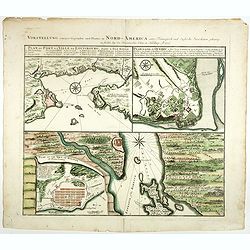
Vorstellung einiger Gegende und Plaetze in Nord America.
The title of the map in English: Picture of some surroundings and towns under French and English jurisdiction. With town plans of Louisburg on Isle Royal, Quebec and Hali...
Place & Date: Nurmberg 1756

San Diego Bay. (Chart 5107)
Nautical chart of San Diego Bay of 1945. Printed in black, yellow and purple the "Seaward limit defensive sea area". The water area within the indicated limits ...
Place & Date: Washington, 1945
![[Incas lay siege to Cusco.]](/uploads/cache/40353-250x250.jpg)
[Incas lay siege to Cusco.]
Atahualpa’s brother, Manco, organized a long and bloody siege to reoccupy the Inca capital, which eventually spread to open rebellion throughout the land. Pizarro, who ...
Place & Date: Frankfurt, M.Merian, 1633
![[The Dutch covalesce on the Isle Santa Clara.]](/uploads/cache/40359-250x250.jpg)
[The Dutch covalesce on the Isle Santa Clara.]
Many of the Dutch were in poor health after their Atlantic crossing and when they found an island to the north of Rio de Janeiro, called Santa Clara, (I. do Francez) they...
Place & Date: Frankfurt, M.Merian, 1633
![[The dogs of Vasco Nunez de Balboa attacking native Indians]](/uploads/cache/40484-250x250.jpg)
[The dogs of Vasco Nunez de Balboa attacking native Indians]
A brutal scene in which the dogs of the Spanish explorer Vasco Nunez de Balboa, ferociously attack native Indians, while the Spanish look on.In 1631 Johann Ludwig Gottfri...
Place & Date: Frankfurt, M.Merian, 1633

(Totius Americae nova et exacta tabula ex) optimis tum geographorum tum aliorum scriptis collecta et ad hodiernam regnorum principatuum et maiorum partium distinctionem accomodata.
Eastern part of a two-sheet map of America, with attribution to Willem Blaeu. According to Philip Burden, the map was derived from Cornelius Danckert's 1647 map of the sa...
Place & Date: Rome, 1679
![The Coast of New Found Land From Salmon Cove to Cape Bonavista. . . [together with] The Coast of New Found Land from Cape-Raze to Cape St-Francis.](/uploads/cache/40658-250x250.jpg)
The Coast of New Found Land From Salmon Cove to Cape Bonavista. . . [together with] The Coast of New Found Land from Cape-Raze to Cape St-Francis.
Two charts showing the coast of New Found Land from Salmon Cove to Cape Bonavista and from Cape-Raze to Cape St-Francis. With inset chart of Trinity HarborGrierson publis...
Place & Date: Dublin, 1767

The Harbour of Casco Bay and Islands Adjacent Bt Capt. Cyprian Southicke.
The earliest printed chart of Casco Bay, an inlet of the Gulf of Maine on the southern coast of Maine, New England. First issued in 1720 by Mount and Page, it remained in...
Place & Date: Dublin, 1767

Nova Virginiae Tabula.
A fine example of Blaeu's map of Virginia and the Chesapeake region is based on the first state of Smith's map, 1612, and is slightly larger and more expertly engraved.Th...
Place & Date: Amsterdam, 1640

Carte de LA LOUISIANE et des PAYS VOISINS Dédiée a M. Rouillé Dediee a M. Rouille Secretairr 'd Etat ayant le Departement de la Marine... 1750
North America from the eastern seaboard to the Rocky Mountains. Based on Delisle's map of 1718 with additions from notes compiled by the Jesuit priest, explorer and histo...
Place & Date: Paris, 1750

Le Isole di Sandwich delineate sulle osservazioni del Cap Cook.
FIRST EDITION on laid paper. Cassini’s splendid map depicts Sandwich islands, old name for Hawaii islands, at the end of the eighteenth century. The splendid cartouche ...
Place & Date: Rome, 1798

Archipelague du Mexique ou sont les Isles de Cuba..
Scarce map of Caribbean. A visually stunning map with a large title cartouche. This large one-sheet map was produced by the Venetian cosmographer Vincenzo Coronelli when ...
Place & Date: Paris, 1688

Driving chart of Hartford and vicinity : 15 miles around.
Road map by Albert A. Hyde & Co. of Hartford and vicinity, with the Connecticut River in the center. Published by Albert A. Hyde & Co., in New York and lithograph...
Place & Date: New York / Philadelphia, 1884

Coast to Coast.
A game board that features a map of the U.S. with a built-in spinner. Players travel a circular track around the map visiting landmarks as they go. A fun way to learn geo...
Place & Date: New York, ca. 1950
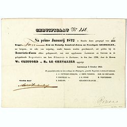
Certificaat N° 230
Text reads "Na primo januarij 1872 is houder dezes geregtigd voor 2/2147 tot hetgeen, ter zake van verjariing, zoude kunnen worden gereclmeerd, uiy gelden bij de Ass...
Place & Date: Amsterdam, 1841

A Map of the British Empire in AMERICA with the French, Spanish and Hollandish Settlements Adjacent Thereto. by Henry Popple. / Nouvelle Carte Particuliere de L'Amerique . . .
The four sheet Dutch edition of Popple's monumental map of North America, in mint condition. Encompassing the West Indies, Florida, Louisiana, Texas and Central America.T...
Place & Date: Amsterdam, ca. 1737

Pascaerte vande Caribische Eylanden, vande Barbados tot aende Bocht van Mexico ‘t Amsterdam By Hendrick Doncker. . .
First state. Rare. “This chart appeared in the first edition of Hendrick Doncker’s Zee-Atlas, of which no surviving example is known” -- Burden. This is an example ...
Place & Date: Amsterdam, 1659

Cunard to Canada.
Poster by Charles Eddowes Turner for Cunard lines. The poster shows The NEW SYLVANIA, one of the four new 22,000 - ton Cunarders which are the largest ever built for serv...
Place & Date: England, ca. 1930
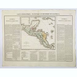
Carte Geographique, Statistique et Historique de Guatimala.
A nice detailed map of Guatemala from Buchon's Atlas Gégraphique Statistique, historique et chronologique des deux Ameriques et des isles adjacentes traduit de l'atlas e...
Place & Date: Paris, 1825

Carte Geographique, Statistique et Historique de l'Amerique Meridionale.
A nice detailed map of South America from Buchon's Atlas Gégraphique Statistique, historique et chronologique des deux Ameriques et des isles adjacentes traduit de l'atl...
Place & Date: Paris, 1825

Carte Geographique, Statistique et Historique du Perou.
A nice detailed map of Peru from Buchon's Atlas Gégraphique Statistique, historique et chronologique des deux Ameriques et des isles adjacentes traduit de l'atlas exécu...
Place & Date: Paris, 1825

Carte Geographique, Statistique et Historique de Buenos-Ayres.
A nice detailed map of what is today northern Argentina (Rep. of Buenos Ayres or the United Provinces of South America) from Buchon's Atlas Gégraphique Statistique, hist...
Place & Date: Paris, 1825
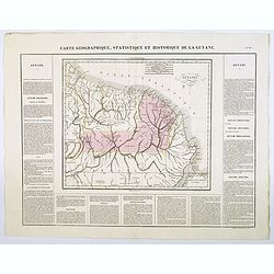
Carte Geographique, Statistique et Historique de la Guyane.
A nice detailed map of Guyana from Buchon's Atlas Gégraphique Statistique, historique et chronologique des deux Ameriques et des isles adjacentes traduit de l'atlas exé...
Place & Date: Paris, 1825
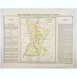
Carte Geographique, Statistique et Historique du Paraguay.
A nice detailed map of Paraguay from Buchon's Atlas Gégraphique Statistique, historique et chronologique des deux Ameriques et des isles adjacentes traduit de l'atlas ex...
Place & Date: Paris, 1825
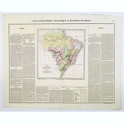
Carte Geographique, Statistique et Historique du Bresil.
A nice detailed map of Brazil from Buchon's Atlas Gégraphique Statistique, historique et chronologique des deux Ameriques et des isles adjacentes traduit de l'atlas exé...
Place & Date: Paris, 1825

Mapa geogra´fico de la mayor parte de la Ame´rica Meridional que contiene los paises por donde debe trazarse la li´nia divisoria que divida los dominios de Espan~a y Portugal. . .
Rare first edition of the map drawn by Francisco Requena (1743-1824) after his expedition to the Amazon in order to delineate the boundary between the Spanish and Portugu...
Place & Date: Bourquin, F. Philadelphia, ca. 1876

Naaukeurige Platte Grond van den Staat en den Loop van Rio de Berbice Met derzelver Plantagien in de Geoctrojeerde Colonie de Berbice Gelegen. . .
Uncommon large-scale map of Berbice with Rio de Berbice and Rio de Canjewith at the bottom left a list of plantation owners. In top 3 x 3 coats of arms in cartouches. The...
Place & Date: Amsterdam, 1742

Rooseveld rekende verkeerd ! De vangarmen van De Dollarpoliep worden afgesneden. . .
An remarkable Anti-American Dutch World War II propaganda poster by Lou Manche, showing an pink octopus, representing the United States, with its tentacles being cut from...
Place & Date: The Netherlands, 1942

Guaranty Trust Company of New York. Emprunt national 6%.n Souscrivez.
Very decorative propaganda poster with design by Mark All of Paris for "Guaranty Trust Company of New York", a JPMorgan Chase predecessor in order to promote th...
Place & Date: Paris, 1918

Novi Belgii novae que Angliae nec non partis Virginiae..
The third state with Fort Kassimier and Philadelphia and nearby placenames added. To the south the Dutch colony of Nieu Amstel. New nomenclature and a key appear around t...
Place & Date: Amsterdam, 1684

Cunard Cherbourg-New York.
Original vintage Cunard luxury cruise liner travel poster advertising Cunard Europe to all America fastest ocean service in the world. Stunning design featuring two color...
Place & Date: England, ca. 1930

Sabena (USA - NYC).
Sabena Belgian World Airlines poster showing the skyline of New York in abstract style. Published by Rali Brisart in Belgium.La Sabena, acronym for Societé Anonyme Belg...
Place & Date: Brussels, ca. 1970