Browse Listings in Asia

Siberia & Central Asia.
This map covers the eastern section of Russia as well as China, Japan, Korea, India and Tibet. The map is of interest for the use of Sea of Corea, the sea between Korea a...
Place & Date: Boston, 1835
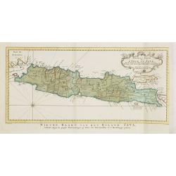
Nouvelle carte de l'Isle de Java.
A very nice map centred on the island of Java.With French text in title cartouche and an additional title in Dutch underneath the map.Read more Early maps of South East A...
Place & Date: Amsterdam, 1773
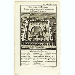
Temple de la Mecque fidelement copiée sur un dessein de la bibliothèque Bodléienne, à Oxford.
View of the Mecca Temple.
Place & Date: Pqris, ca. 1780
![[Map of the Holy Land, including Cyprus]](/uploads/cache/33436-250x250.jpg)
[Map of the Holy Land, including Cyprus]
Attractive full page longitudinal map of Palestine, Syria and Cyprus, cut by Hans Rudolf Manuel Deutsch. The shore line running from Southern Anatolia to the Nile Delta. ...
Place & Date: Basle, 1550-1580

Partie de la Chine N°87. (Covers Jiangxi, Fujian and parts of Zhejiang, Guangdong, Hunan and Hubei.)
Covers Jiangxi, Fujian and parts of Zhejiang, Guangdong, Hunan and Hubei.From his famous Atlas Universel . This atlas was one of the most remarkable world atlases ever pr...
Place & Date: Brussels, 1825-1827

L'Arabie.
Small detailed map of the Arabian Peninsula. From Atlas Portatif Universel, by Robert de Vaugondy.Page 162 outside border top right.
Place & Date: Paris, later than 1749
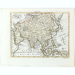
Asia.
Detailed map the Asian continent. The map is of interest for the use of Sea of Corea, the sea between Korea and Japan.
Place & Date: Amsterdam, 1682
Selling price: $225
Sold in 2023

Costumes des habitans de Manille.
A very beautiful print, showing four elegant figures relaxing in a shady glade, two women recline and two stand chatting.After a design of Duché de Vancy and engraved by...
Place & Date: Paris, 1798

Vue et Description de Quelques-Uns des Principaux Forts des Hollandois dans les Indes .
Interesting sheet with seven detailed views illustrating the most important Dutch V.O.C. trading outposts and fortified colonial possessions in the East Indies, including...
Place & Date: Amsterdam, 1720

Partie de la Chine N°86. (Covers Guizhou and parts of Yunnan, Guangxi, Hunan, Hubei and Sichuan.)
Covers Guizhou and parts of Yunnan, Guangxi, Hunan, Hubei and Sichuan.From his famous Atlas Universel . This atlas was one of the most remarkable world atlases ever produ...
Place & Date: Brussels, 1825-1827