Browse Listings

ADSEC in Action from Thames to Rhine.
A pictorial map showing the allied movement from London on 14 March 1944 thru the conquest of Germany. Showing the track from London along Bristol, crossing the British C...
Place & Date: London, 1945

Stoel des Oorlogs in America Waar in Vertoont Werden Alle Desself Voornaamste Eylande . . .
Large impressive map of the West Indies with the Gulf of Mexico and Florida. The map shows prominently in the center Cuba, Haiti, the Bahamas and Florida, which is here m...
Place & Date: Amsterdam, c. 1720

Asia secunda pars in forma Pegasi.
UNRECORDED PLATE or STATE. Asia depicted as the flying horse Pegasus. Below the depiction 3 lines of engraved Latin text. Double page copper engraved map from Heinrich B�...
Place & Date: Brunswick, ca. 1635

Asia secunda pars terrae in forma Pegasi.
Asia depicted as the flying horse Pegasus. Thiscartographical curiosity, double page copper engraved map, was published in Heinrich Bünting's “Itinerarium Sacrae Scrip...
Place & Date: Brunswick, 1640

Langley's New Travelling and Commercial Map . . .
A highly desirable, detailed and uncommon map of England and Wales, published by Langley and Belch. The map is flanked by a pair of large and detailed explanation tables,...
Place & Date: London, 1817

Habillement de l'Empereur de la Chine & des Dames de son Palais..
This impressive engraving is a wonderful example of Chatelain’s elegant plates.Divided in 3 panels, showing examples of costumes of Chinese ladies and those of the king...
Place & Date: Amsterdam, ca. 1728

Carte de la Mer Rouge, depuis Moka jusqu's Gedda. . . .
Chart of the Red Sea. With 3 inset maps of Shake Omare, Goofs and Gedan. D'Après De Mannevillette (1707-1780) was one of France's first hydrographers. When the first edi...
Place & Date: Paris, 1753
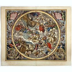
Coeli Stellati Christiani Haemisphaerium Prius.
Scarce first issue. This spectacular celestial chart presents the constellations according to Christian symbolism. The view of the constellations is based on the work of ...
Place & Date: Amsterdam, 1660

Pecheli, Xansi, Xantung, Honan, Nanking, In plaga Regni Sinensis. . .
A map of the northern provinces of China after the Jesuit Martino Martini, depicting of Hebei (Pecheli), Shanxi (Xansi), Shandong (Xantung), Henan (Honan), and Jangsu (Na...
Place & Date: Amsterdam, ca 1660
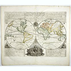
Mappe-Monde pour connoitre les progres & les conquestes..
Unusual double hemisphere map with California as an Island. Dutch text describes the expeditions and colonial possessions of the Dutch East India Company. The map origina...
Place & Date: Amsterdam, 1729