Browse Listings in Europe > British Isles

Wallis's Guide for Strangers Through London.
Engraved plan with original hand-coloring, with title and alphabetical list of the principal streets below. Published by Edward Wellis 42 Skinner Street.With "An alp...
Place & Date: London, E.Wallis, ca. 1840

Het Canaal tusschen Engeland en Vranciick.
An eye-catching chart of the Channel.Pieter Goos (ca. 1616-1675) was one of the most important cartographers, engravers, publishers and print sellers of Amsterdam. His wi...
Place & Date: Amsterdam, after 1666

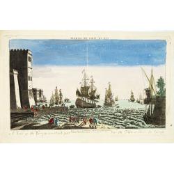
AFFAIRES D'ORIENT Départ des Grenadiers de la Garde Anglaise, à bord du Steamer transatlantique l'Orenoco. . .
Beautiful lithography of the British steamboat "l'Orenoco" departure from Southampton in May 1854, with soldiers leaving for the Crimean War. After a design Lou...
Place & Date: Paris, Lemercier, c.1860

.Paskaarte om Achter Yrlandt om te Zeylen van Hitlant tot. . .
An eye-catching chart of Ireland, including the north of England and Scotland, with the West to the top.Pieter Goos (ca. 1616-1675) was one of the most important cartogra...
Place & Date: Amsterdam, 1673
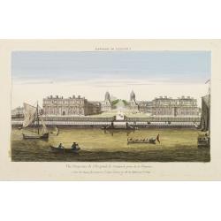
Vüe Perspective de l'Hospital de Greenwich prise de la Thamise.
So-called optical print illustrating a perspective view of Greenwich Hospital, illustrating its close proximity to the River Thames.In the eighteenth and nineteenth centu...
Place & Date: Paris, 1760
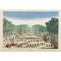
77e Vüe d'Optique Représentant Les Cascades du Jardin de Vauxhall a Londres.
So-called optical print illustrating a perspective view of the fountains and artificial cascades in Vauxhall Gardens, London.In the eighteenth and nineteenth centuries th...
Place & Date: Paris, 1760

Bowles's new four-sheet map of England and Wales. . .
Bowles's new four-sheet map of England and Wales: Comprehending all the Cities, Boroughs, Market and Sea-Port Towns, Villages, Lakes, Rivers, Forests, Ruins, Canals, and ...
Place & Date: London, 1801

Parte settentrionale dell' Irlanda / Irlanda parte meridionale . . .
A beautiful and flamboyantly engraved grand two-sheet map of Ireland. Embellished with two cartouches, a vessel under sail and a sea monster.The map is the product of the...
Place & Date: Venice, 1696
A view of the Gerzay near Iside part. / Vue du port et rade de Gerzay.
A fanciful depiction of the port of Jersey. Engraved by the French engraver Paul Angier after a design by P.Brookes and published by Robert Sayer of London, a well-known ...
Place & Date: London, ca. 1760

Vüe Perspective du Pont neuf construit sur la tamise a Hampton-Court.
So-called optical print illustrating a bridge on the river Thames at Hampton-Court.In the eighteenth and nineteenth centuries there were many popular speciality establish...
Place & Date: Paris, 1760