Browse Listings in America > South America
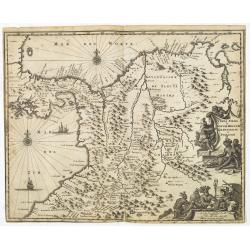
Terra Firma et Novum Regnum Granatense et Popayan.
Detailed map of Panama and northwestern South America derived from the Blaeu/Jansson map of the regionFeaturing ships at sea, two compass roses, and two cartouches depict...
Place & Date: Amsterdam, 1673
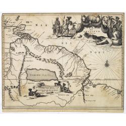
Guiana sive Amazonum Regio.
Map of Guiana and Amazon extending westwards to Trinidad and Margarita Island, dominated by a huge inland sea north of the Amazon.Embellished with decorative title and sc...
Place & Date: Amsterdam, 1673

Tabula Americae Specialis Geographica Regni Peru, Brasiliae, Terra Firmae & Reg: Amazonum, Secundum relationes de Herrera, de Laet & PP d Acuña & M. Rodriguez . . .
A good and clean copy of Homann's map of the northern part of South America. The map is on the Valley of the Amazon and delineates the Amazon and its labyrinth of tributa...
Place & Date: Nuremberg, 1728

Paraquariae Provinciae Soc. Iesu cum Adjacentibus Novissima...
Between the years of 1609 and 1780, the Jesuits (the Roman Catholic Society of Jesus) established in South America, an autonomous Christian state, on the lands of present...
Place & Date: Augsburg, 1740

Naaukeurige Platte Grond van den Staat en den Loop van Rio de Berbice Met derzelver Plantagien in de Geoctrojeerde Colonie de Berbice Gelegen. . .
Uncommon large-scale map of Berbice with Rio de Berbice and Rio de Canjewith at the bottom left a list of plantation owners. In top 3 x 3 coats of arms in cartouches. The...
Place & Date: Amsterdam, 1742

Typus Geographicus Chili Paraguay Freti Magellanici &c.
Detailed map covering the southern part of the continent based on the cartography of Delisle and the information gleaned from the voyages of Brouwer, Narbouroug and Beauc...
Place & Date: Nuremberg, 1750

Nieuwe gemeten kaart van de colonie de Berbice met der zelver plantagiën en de namen der Bezitters. . .
Re-issue of his map from 1740, without the printed list of owners, with a large added contemp. hand-colored cartouche Relaas van de rebellie, ontstaan op de plantagien in...
Place & Date: Amsterdam, ca.1763
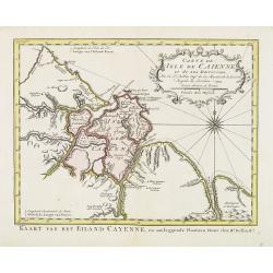
Carte de L'Isle de Caiene et de ses environs.
Uncommon edition of this accurate map of Cayenne. In lower right engraved "31."From Atlas Portatif pour servir a l'intelligence de l'Histoire Philosophique et P...
Place & Date: Amsterdam, 1773

Guyana, Surinam, Amapa.
Very rare Ottoman printed map of Guyana, Suriname and Amapa. With Trinidad, an inset map of the mouth of the Rivers Essequibo, Courantyne, Suriname with Paramaribo.From C...
Place & Date: Üsküdar (Istanbul), 1803

Paraguay, Chili, Terre Magellan ?
Map of Paraguay, Chili, and Argentina . By C. F. Delamarche, successor of Robert de Vaugondy, Geographer.
Place & Date: Paris, 1794 -1806