Browse Listings in America > South America

Rivage du port Saint-Nicolas.
Exquisite contemporary colored lithograph of Port Saint-Nicolmas Bay in most southern part of South America, with Dumont D'Urville's officers making landfall. Drawn by E....
Place & Date: Paris, 1846

Entrée des forêts de la rivière Sedger. . .
Exquisite contemporary colored lithograph of Sedger's river in the Chili, with as seen by Dumont D'Urville's, with Indians. Drawn by Louis Le Breton, lithographed by Bich...
Place & Date: Paris, 1846
![[Incas lay siege to Cusco.]](/uploads/cache/40353-250x250.jpg)
[Incas lay siege to Cusco.]
Atahualpa’s brother, Manco, organized a long and bloody siege to reoccupy the Inca capital, which eventually spread to open rebellion throughout the land. Pizarro, who ...
Place & Date: Frankfurt, M.Merian, 1633
![[The Dutch covalesce on the Isle Santa Clara.]](/uploads/cache/40359-250x250.jpg)
[The Dutch covalesce on the Isle Santa Clara.]
Many of the Dutch were in poor health after their Atlantic crossing and when they found an island to the north of Rio de Janeiro, called Santa Clara, (I. do Francez) they...
Place & Date: Frankfurt, M.Merian, 1633

Guyana, Surinam, Amapa.
Very rare Ottoman printed map of Guyana, Suriname and Amapa. With Trinidad, an inset map of the mouth of the Rivers Essequibo, Courantyne, Suriname with Paramaribo.From C...
Place & Date: Üsküdar (Istanbul), 1803
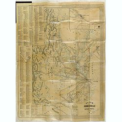
Plano de los Ferro-Carriles de Republica Argentina 1902.
Folding rail road map of Argentina, with inset of Buenos Aires in upper right corner.
Place & Date: Buenos Aires, ca. 1902

Il Cuscho citta principale della provincia del Peru.
A very desirable and scarce item of this decorative and early bid's-eye town-plan of the Inca city of Cuzco. Several figures shown inside the city walls and on the hillsi...
Place & Date: Lyons, 1564
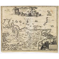
Venezuela cum parte Australi Novae Andalusiae.
Most decorative map with two large cartouches and compass-rose, large group of islands at the mouth of the Orinoco, other islands off Venezuela coast: Margarita, Aruba, C...
Place & Date: Amsterdam, 1673
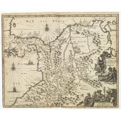
Terra Firma et Novum Regnum Granatense et Popayan.
Detailed map of Panama and northwestern South America derived from the Blaeu/Jansson map of the regionFeaturing ships at sea, two compass roses, and two cartouches depict...
Place & Date: Amsterdam, 1673
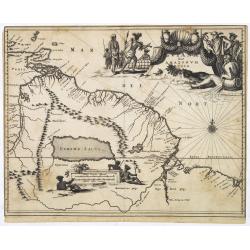
Guiana sive Amazonum Regio.
Map of Guiana and Amazon extending westwards to Trinidad and Margarita Island, dominated by a huge inland sea north of the Amazon.Embellished with decorative title and sc...
Place & Date: Amsterdam, 1673