Browse Listings in America > South America
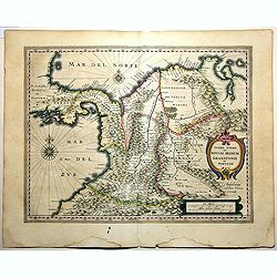
Terra Firma et Novum Regnum Granatense et Popayan.
A handsome map of modern-day Panama and Colombia. The cartouches and decoration are colored in an artistic way. Very fine and rare with this type of coloring.From "l...
Place & Date: Amsterdam, 1635-1638
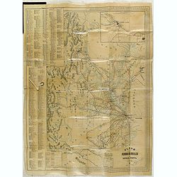
Plano de los Ferro-Carriles de Republica Argentina 1902.
Folding rail road map of Argentina, with inset of Buenos Aires in upper right corner.
Place & Date: Buenos Aires, ca. 1902

Brasila.
Map of Brazil extending from C. Nasou and Parime Lago to the Mouth of the Rio de la Plata. Oriented with West on top.The cartography of the region is quite primitive. The...
Place & Date: Amsterdam, 1673
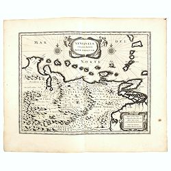
Venezuela cum parte Australi Novae Andalusiae.
German text on verso. A finely engraved, decorative map of Venezuela. The islands of Trinidad and Tobago, Margarita, Aruba, and Curaçao are shown. With a decorative titl...
Place & Date: Amsterdam, 1634

Il Cuscho citta principale della provincia del Peru.
A very desirable and scarce item of this decorative and early bid's-eye town-plan of the Inca city of Cuzco. Several figures shown inside the city walls and on the hillsi...
Place & Date: Lyons, 1564

Tabula Magellanica.
A map with Willem Blaeu's signature, but published by his son Joan, of South America's extremity with the Strait of Magellan and Le Maire Strait.The coastlines are depict...
Place & Date: Amsterdam, 1658

Nieuwe gemeten kaart van de colonie de Berbice met der zelver plantagiën en de namen der Bezitters. . .
Re-issue of his map from 1740, without the printed list of owners, with a large added contemp. hand-colored cartouche Relaas van de rebellie, ontstaan op de plantagien in...
Place & Date: Amsterdam, ca.1763

Nuevo plano de la ciudad de Buenos Aires y parte del partido de avellaneda . . .
A rare detailed city plan of Buenos Aires prepared in 1912 by Ernesto Escalante. The plan depicts the city from the Partido de Avellaneda and the Villa Riachuelo to the R...
Place & Date: Buenos Aires, 1912

Guyana, Surinam, Amapa.
Very rare Ottoman printed map of Guyana, Suriname and Amapa. With Trinidad, an inset map of the mouth of the Rivers Essequibo, Courantyne, Suriname with Paramaribo.From C...
Place & Date: Üsküdar (Istanbul), 1803
![Hanc Tabulam continens Laetam Pharnambuci.. . [Brazil].](/uploads/cache/16521-250x250.jpg)
Hanc Tabulam continens Laetam Pharnambuci.. . [Brazil].
An extremely rare and decorative map of coast-line of Pernambuco. With one inset: In the upper left corner a map of Brazil, with title in five lines Dutch and five lines ...
Place & Date: Amsterdam, 1630