Browse Listings

Gustaaf Willem Baron van Imhoff.
Decorative portrait of Gustaaf Willem Baron van Imhoff, who was Governor for the V.O.C. (Dutch East Indian Company) in Indonesia.
Place & Date: Amsterdam, 1745

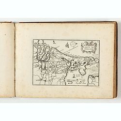
(upper sheets only) Asia According to the Sieur D'Anville Divided into its Empires, Kingdoms and States Showing the European Settlements in the East Indies and all the New Discoveries made by the Russians, the Dutch and the English . . . 1772
Highly detailed map of Russia, including Turkey, China and Korea. Based on the cartography of the famous French cartographer Jean Baptiste Bourguignon d' Anville. Only th...
Place & Date: London, 1772

Tablaeu de l'Univers premiere partie/ .. seconde partie.
Uncommon and interesting manual containing a double hemisphere world map (with fine outer decoration and showing an imagined great sea in West America, easily the size of...
Place & Date: Luik, Belgium, 1784
![[West Central London from Booth's Poverty Map of London]](/uploads/cache/40267-250x250.jpg)
[West Central London from Booth's Poverty Map of London]
A map of West Central London, one section (of twenty) of an extended version of the incredibly influential Poverty Map, originally published in Charles Booth's 'Life and ...
Place & Date: London, 1900
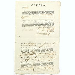
ACTION N° 1155. Société du Commerce d'Asie & d'Afrique.
Share of 1 000 Florins d'Allemagne (1 000 Guilder) of the "Triester Handelsgesellschaft" (Société du Commerce d'Asie & d'Afrique) signed by duke Charles d...
Place & Date: Triest / Antwerpen, 1 October 1781
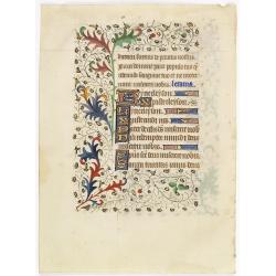
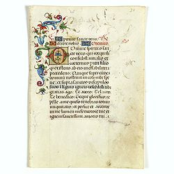
A manuscript leaf from a Book of Hours.
RECTO: Four 1-line initials in liquid gold on colored grounds. colorful panel border of acanthus leaves and flowers, with black penwork.VERSO: One 2-line initial and seve...
Place & Date: Western France, ca. 1445
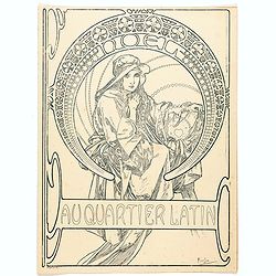
Au quartier Latin.
This image also appears on the Christmas cover of the magazine in 1900. This is the version before the magazine boilerplate was added, but "this black-and-white vers...
Place & Date: Paris, ca. 1899

Carte d'Afrique Dressée pour l'instruction par Guillaume DeLisle. . .
The map is a rare re-issue of the Delisle map of 1722. In his first map of the continent in 1700, Delisle re-measured the Mediterranean, being the first to establish its ...
Place & Date: Paris, J.Dezauche, 1819
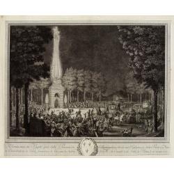
Réjouissances du Peuple près de la Pyramide d'Illumination, élévée sur l'Esplanade de la Porte de Mars et Distribution de Vivres, fontaines de Vin , sous les Ordres de Mrs. Du Conseil de la Ville, à Reims le 27 Aoust 1765.
Engraved by Varin after Moreau Jr. The print shows a lightning spectacle held in Reims on 27 August 1765.
Place & Date: Paris, 1771

(Art-déco gouache)
Outstanding "art deco" gouache (unsigned) from the workshop of "Robert Pichon. Ateliers de Dessin et Lithographie – 10, rue Rochechouart – Paris. The g...
Place & Date: Paris, ca. 1930

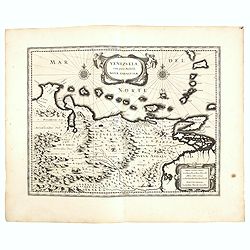
Insulae de Cabo Verde olim Hesperides sive .. Zoute Eylanden.
Original copper engraving, hand colored in outline, when published. Double page chart covering detailed the Cap Verde Islands in the Atlantic Ocean (Isla de San Antonia, ...
Place & Date: Amsterdam, 1655
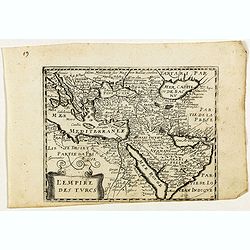
L'Empire des Turcs.
Rare map of the Turkish empire, published by Jollain in 1667. Published in "Trésor Des Cartes Geographiques Des Principaux Estats de Lunivers".Showing "&q...
Place & Date: Paris, 1667

Manoeuvres executées du 7 au 13 mai sous le Commandement du général Koeltz,par le XIXe Corps d'Armée. . .
Poster by Gaston Ry [aka René Rostagny] (1902-1978) showing the allied manouvers in Tunesia. On May 4, 1943, the nineteenth CA offensive drew most of the German tanks to...
Place & Date: Alger, Bacconnier, 1943

Carte de la Mer Rouge, depuis Moka jusqu's Gedda. . . .
Chart of the Red Sea. With 3 inset maps of Shake Omare, Goofs and Gedan. D'Après De Mannevillette (1707-1780) was one of France's first hydrographers. When the first edi...
Place & Date: Paris, 1753

Key Map of Hong Kong Relative to Canton and Macao.
A nice folded map of Hong Kong and the surrounding areas. Produced by the British Crown Lands Survey Office just after WWII. Physical features are shown by contour. Railw...
Place & Date: Hong Kong, 1948

Het Canaal tusschen Engeland en Vranciick.
An eye-catching chart of the Channel.Pieter Goos (ca. 1616-1675) was one of the most important cartographers, engravers, publishers and print sellers of Amsterdam. His wi...
Place & Date: Amsterdam, after 1666
![Flandra parte occidentale: dedicata all'illustrissimo et eccelententissimo S. Giorgio Cocco, senatore meritissimo. . . [together with] Zelanda e Parte Orientale della Flandra. . . .](/uploads/cache/31286-250x250.jpg)
Flandra parte occidentale: dedicata all'illustrissimo et eccelententissimo S. Giorgio Cocco, senatore meritissimo. . . [together with] Zelanda e Parte Orientale della Flandra. . . .
Wall sized map of two joined sheets of Flanders, the coastline running from Calais to Zeeland in the Netherlands. Including major cities along the coast such as Dunkerque...
Place & Date: Venice, 1696

Insularum Moluccarum Nova description.
Exquisite map of the famous Spice Islands based on the islands described by Jan Huyghen van Linschoten. This map was the first large-scale map of the region and depicts t...
Place & Date: Amsterdam, 1730
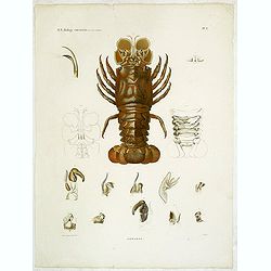
Hommards.
Decorative engraving of a lobster, by Tresca. Marie Jules César Lelorgne de Savigny (April 5, 1777 - October 5, 1851) was a French zoologist. In 1798 he traveled to Egyp...
Place & Date: Paris, 1822

Novus XVII Inferioris Germaniae Provinciarum Typus.
Willem Blaeu published this map in 1608 as a wall map with figured borders. When later, in 1630 he needed a general map of the Netherlands for his first atlas, the Append...
Place & Date: Amsterdam, 1634
Venezuela cum parte Australi Novae Andalusiae.
German text on verso. A finely engraved, decorative map of Venezuela. The islands of Trinidad and Tobago, Margarita, Aruba, and Curaçao are shown. With a decorative titl...
Place & Date: Amsterdam, 1634

Plan of part of the islands or archipellago of Corea seen in May 1787 by the Boufsole and Astrolabe.
This is a representing the visit of the French Admiral and explorer, le Comte de La Pérouse to Korea in 1786. The tracks of La Perouse are shown.From 'Atlas du Voyage d...
Place & Date: London, 1798
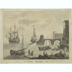
Les environs d'Ostende. XII.
Beautiful view of Oostende. A somewhat fanciful depiction of the harbor of Oostende, with merchant on the foreground and large vessels in the sea. The item is signed (Dre...
Place & Date: Belgium, c. 1811

Carte des Isles du Japon Sequels est remarque la Route..
This uncommon map of Japan, a reduced version of his larger map, contains comments about the nature of the country. For instance, Ocsaqui (Okazaki, near Nagoya) is said t...
Place & Date: Paris / Amsterdam, 1679

Ducatus Limburg.
A very rare issue of this map of Limburg. Cornelis Danckerts II. copied the folio map of H.Hondius.The publisher's address was placed in the lower right-hand corner. The ...
Place & Date: Amsterdam, 1636

(Art-déco gouache)
Outstanding "art deco" gouache (unsigned) from the workshop of "Robert Pichon. Ateliers de Dessin et Lithographie – 10, rue Rochechouart – Paris. The g...
Place & Date: Paris, ca. 1930

Veduta della Piazza della SS. Nunziata, Statua Equestre di Ferdinando Primo, Fonti, e Loggie Laterali.
Lively view of Nunziata square with the statue of Ferdinand I in Florence after Giuseppe Zocchi (1711or 1717 - 1767) and engraved by B.Sgrilli. From "Scelta di XXIV ...
Place & Date: Florence, Bouchard, 1754

Les vallées du Piemont. Habitees par les Vaudois ou Berbets. . .
Detailed map of Piedmont region covering French and Italian territories. Surrounded by a French text description "Description des vallées du Piemont qu'habitent par...
Place & Date: Paris, 1690

Scio. (Chios)
Very rare view of Chios Island published in the first edition of "Viaggio da Venetia, a Costantinopoli. Per Mare, e per Terra, & infieme quello di Terra Santa. D...
Place & Date: Venice, Giacomo Franco, 1598
![.[Italy]](/uploads/cache/33856-250x250.jpg)
.[Italy]
Wood block printed map and one of earliest printed representation of Italy prepared by Martin Waldseemüller. Based on the slightly larger map from 1513 published in &q...
Place & Date: Vienna, Trechsel, G., 1525 -1541
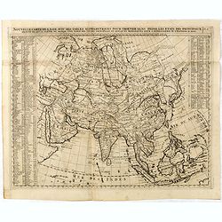
Nouvelle Carte De L'Asie Avec Des Tables Alphabetiques Pour Trouver Sans Peine Les Etats Des Principaux Princes De Cette Partie Du . . .
Chatelain's map of Asia. The title is in two lines across the map. On each side border appears an index to the map's contents.The map is of interest for the use of Mer Or...
Place & Date: Amsterdam, 1719
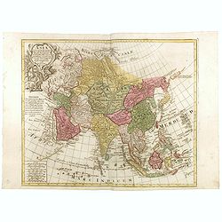
Asia Concinnata Secundum Observationes Academiae Regalis . . .
A version of De L'Isle's map. T.C. Lotter married M. Seutter's daughter in 1740 and succeeded him in 1756. Lotter used the copperplate of Seutter, he only changed the nam...
Place & Date: Augsburg, ca. 1770

Die Stadt Narva. . .
An early of the town of Narva, located at the eastern tip of Estonia, on the Russian border.From the uncommon Hamburg edition "Viel Vermehrte Moscowitische und Pers...
Place & Date: Hamburg, 1696
Leaf on vellum from an Italian manuscript Book of Hours.
A leaf from an Italian Book of Hours, written on vellum in the neighborhood of Ferrara, around 1480.The decorations of this leaf are extraordinary : the bouquet of flower...
Place & Date: Italy, Ferrara, ca.1480
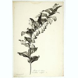
Sceau de Salomon. Convallaria multiflora L.
King Solomon's Seal or David's Harp, engraving by P.F. Le Grand after designs by the Dutch born Gerard van Spaendonck (1746-1822).Taken from the rare work "Fleurs de...
Place & Date: Paris, c.1800

Florentini Dominii Fidelissima et nova descriptio.
The map is centered on the city of Florence and extends to Liguria, the Apennine Mountains, the Adriatic Coast, Siena and Lago di Perugia. The map is based upon Stefano B...
Place & Date: Anvers, 1598
A new & accurate map of Asia drawn from actual surveys. . .
An excellent early engraving of Asia. Curious shape for Japan, with a large island north called Yeso and a coastline marked De Gamma's Land. Numbered "No 52."; ...
Place & Date: London, 1747
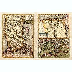
1) Natoliae,.. 2) Aegypti recentior.. 3) Carthaginis..
To the left a map of Turkey. Oriented with west at bottom. Right side of sheet contains a map of northern Egypt showing the Nile River delta, and a map the vicinity of Tu...
Place & Date: Antwerp, 1570-1609

Terrae Yemen Maxima Pars, seu Imperii Imami, Principatus Kaukeban nec non ditionum Haschid u Bekil, Nehhm, Chaulan, Abu Arisch et Aden Tabula ...
South-west Arabia, with the Saudi Arabian city of Jizan south to Aden. With a fine title, cartouche. Based on a map by Carsten Niebuhr. With the name Sinus Arabicus Mare ...
Place & Date: Augsbourg, 1774
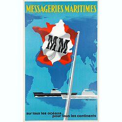
Messageries Maritimes, sur tous les océans, pour tous les continents.
Original lithographed poster from the 1950s by Jean Desaleux. The poster has a blue background and a map of the continents and oceans. France is in the colors of the Mari...
Place & Date: Paris, ca. 1950

Chaerte vande Wieringer waert, de welcke inden jaere XVI… (Wieringerwaard)
Rare wall map of the Wieringerwaard polder, as raffled on 12 July 1611. The polder was laid dry in 1610. It border, and also the border of the municipality, were the Zuid...
Place & Date: 1741-1744

A view of the town and castle of Macao.
A nice engraving that shows the attack of the English ship "Centurion" on Macau, during which she captured a Portuguese ship that had sailed from Manila. In up...
Place & Date: London, 1746

Nouvelle carte du Roiaume D'Alger divisée en toutes ses provinces, avec une partie due cotes D'Espagne . . .
Rare and detailed map of the coast of Algeria. Large inset map of the Bay of Alger (El-Jazir). Shows a coastline of Spain around Alicante. Two compass roses in the Medite...
Place & Date: Amsterdam, 1720

Irlandiae Regnum.
A very nice map from Ireland.Mercator was born in Rupelmonde in Flanders and studied in Louvain under Gemma Frisius, Dutch writer, astronomer and mathematician. The excel...
Place & Date: Amsterdam, 1630
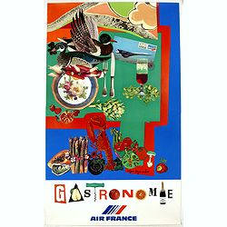
AIR France - Gastronomie
An atypical Air France poster designed by Roger Bezombes in 1980 that turns traditional Air France poster art on its head: if the goal of an advertising poster is to crea...
Place & Date: Murlot, Paris, 1981
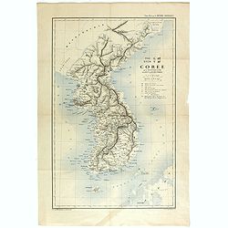
TYO SYEN Corée par les Missionnaires de Corée de la société des missions etrangéres.
A very nice map and rare map of Korea. Prepared by R.P.Carceri who was an missioner active for de la Sociéte des Missions Etrangères.Published as a supplement to Journa...
Place & Date: Lyon, 1872
Selling price: $700
Sold in 2023

Paskaert vande Bocht van Vranckrijck Biscajen. . .
An eye-catching chart of the coast of Bretagne from Brest running south till the coast of Biscay in Northern Spain.Including the towns of Ferrol in the west, Gijon, Santa...
Place & Date: Amsterdam, after 1666
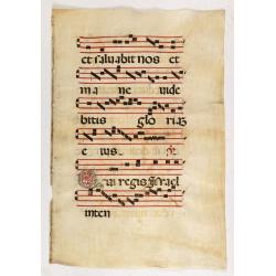
Leaf on vellum from an antiphonary.
A large vellum antiphonary leaf, written in Latin , probably Rome. RECTO: A wonderful initial "Q",, decorated with penwork in red, white and blue, in rich burni...
Place & Date: Italy, 1480
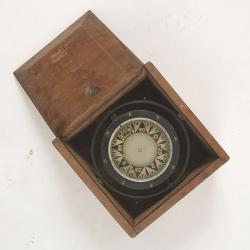
Compass.
A sloop compass in the original wooden box with lit. The compass with floating rose (Cardan system). Slung in gimbals, the east point is decorated and graduated in half ...
Place & Date: c. 1890-1900

Latium.
Based on classical authors' sources, specifically Virgilius, Plinius, Varro, Halicarnasseus, Festus and Ausonius.Philip Wingius in his letter to Ortelius from 1592 mentio...
Place & Date: Antwerp, 1595

Kort begrip der oude en nieuwe staatkundige Geographie: behelzende eene beschryving der heerschappyen, in welken de aarde verdeeld is, haare gelegenheid. . .
Sixth edition- Interesting geographical compendium, prepared by Johann Hubner en W.A. Bachiene. Of particular interest is the section starting with pages 589 with "O...
Place & Date: Amsterdam, Covens / Mortier, Utrecht, Poolsum, 1758
Mappe-Monde pour connoitre les progres & les conquestes..
Unusual double hemisphere map with California as an Island. Dutch text describes the expeditions and colonial possessions of the Dutch East India Company. The map origina...
Place & Date: Amsterdam, 1729

Le Duché d'Aiguillon Tracé Par le Sr. Du Vall.
Home of the "Cahors” This AOC is the most famous of the sub-regions and home to the popular variety Malbec. These inky wines have been adored for centuries, especi...
Place & Date: Amsterdam, 1650
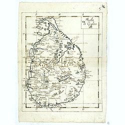
Isola Di Ceylan. (Manuscript map of Sri Lanka)
Manuscript map of Sri Lanka (Ceylon). Inland filled with a good number of place names, mountains.
Place & Date: Italy, ca. 1750
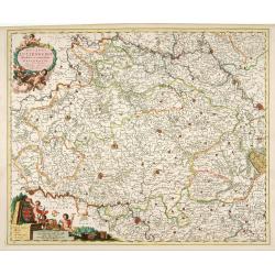
Ducatus Lutzenburgi Novissima et Accuratissima Delineatio.
West to the top. Very detailed and fine map of Luxembourg, including the towns of Namur, Liege, Trier and Metz.
Place & Date: Amsterdam, 1680
![[Set of World and 5 continents - 7 maps ].](/uploads/cache/44957-250x250.jpg)
[Set of World and 5 continents - 7 maps ].
One of the last decorative maps of the 19th century. In side panels representations of the four seasons, figures, local scenes. World map, Europe, Asia, North America, Af...
Place & Date: Paris, 1850

Ilse Paese de' Selvaggi.. Lago Superiore. (Florida and the Bahamas)
Antonio Zatta published an Italian version of the John Mitchell map in twelve sheet. This sheet depicts Lake Superior in the Bellin version, as it appeared on the Mitchel...
Place & Date: Venice, 1778

Carte du Gouvernement de Provence, suivant les nouvelles observations...
Fine copper engraved and decorative map of the Provence region in the south of France. It includes the cities of Nimes, Viviers, Avignon, Aix and Nice. The pictorial cart...
Place & Date: Amsterdam 1728
Genehoa Jaloffi et Sierraliones regna.
Decorative and detailed map of the West African Coast, from Senegal to Sierra Leone. In the center the river Gambia to the mouth in the Atlantic. Upper left a dedication ...
Place & Date: Amsterdam, 1670 / 1720
![[Portrait] Johannes Baptista Homann . . .](/uploads/cache/36599-250x250.jpg)
[Portrait] Johannes Baptista Homann . . .
Stunning full portrait of the Imperial Geographer of the Holy Roman Empire, Johann Baptist Homann (1664-1724) who was born in the Bavarian town of Kammlach. Educated at a...
Place & Date: Nuremberg, c.1740

Reis-kaart van het Britsche gezantschap van Hang-choe-foe naar Quang-choe-foe of Kanton in China.
Uncommon map of eastern part of China, showing a journey of the English Embassy from Hangzhou (south of Shanghai) to Guangzhou (Canton). The maps is giving a wealth of in...
Place & Date: Netherlands, c.1800

La Tartaria Chinese.
With decorative title cartouche. Covering north eastern part of China, with good detail in Korea and a curious shape for Hokkaido (here called Jeso-Gasima ).Engraved by G...
Place & Date: Venice, 1784
![Traiectum ad Mosam. [Maastricht]](/uploads/cache/47901-250x250.jpg)
Traiectum ad Mosam. [Maastricht]
A birds-eye view of Maastricht seen from the south. Rising on Vrijthof square is the dominant complex of Sint-Servaas, in front of which - seen here in a distorted perspe...
Place & Date: Cologne, ca. 1581

Vue de L'Hotel de Batavie. . .
A so-called optical print of Fatahillah Square in Jakarta, Indonesia, prepared for use in a light-box or an amusing light-show. This richly hand colored print is much per...
Place & Date: Augsburg, 1750

Portugalliae que olim Lusitania..
The best-known map of Portugal, after Alvares Secco (1560), orientated west to the top of the sheet. Secco's map was copied by many mapmakers and publishers for upwards o...
Place & Date: Amsterdam, 1628

Plan de la ville de Maestricht avec ses attaques commandées par M. le maréchal de Saxe, depuis le 15 avril jusqu'au 3 may 1748 . . .
A plan of Maastricht rising after the capture of the city by the French troops led by the Marshal of Saxony. The city was besieged between 15 April and 3 May 1748, during...
Place & Date: Paris, 1781

Mastric ou Maëstricht, Ville du Brabant-Hollandois. . .
A very decorative and extremely rareof Maastricht, including a numbered key (1-23) in lower part. Engraved by Pierre-Alexandre Aveline. With "Fait par Aveline avec p...
Place & Date: Paris, ca.1692

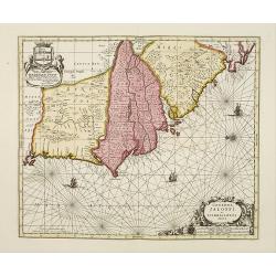
L'Inde de la le Gange, suivant les nouvelles observations...
Uncommon edition of this map of Malaysia, Thailand, Indo China and the Northern parts of the islands of Sumatra and Borneo. Singapore marked as Sincapour. With decorative...
Place & Date: Amsterdam, 1728

Cust van Hollant Tussen de Maes ende Texel.
Uncommon chart of the coast of Holland, including the southern tip of Texel. East at the top. Two fine compass cards, soundings and a large Bree Veerthien offshore.Piete...
Place & Date: Amsterdam, 1666

Designs for porcelain vase with Chinese motif.
With attractive pattern of a classic Chinese motif. In top "Planche d'aquarelle N° 04510" and the numbers 2,198. Original design created by the Sevres artist G...
Place & Date: Desvres, 1905 - 1925

Designs for porcelain vases with Chinese motif.
Hand colored design of 13 vases with attractive patterns of a classic Chinese motif. In right "Planche d'aquarelle N° 04004" and the numbers 7.404, 2.074, 8.93...
Place & Date: Desvres, 1905 - 1925
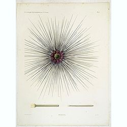
Oursins.
Decorative plate of a sea urchin, engraved by Boquet. Marie Jules César Lelorgne de Savigny (April 5, 1777 - October 5, 1851) was a French zoologist. In 1798 he traveled...
Place & Date: Paris, 1822

Marcomania hoggidi Merchesato de Moravia. . .
Although Komensky's map of Moravia was already known in his time, Coronelli used the obsolete map by Fabricius, with a lot of locations added by the publisher's unchained...
Place & Date: Venice, 1696

Grande Pologne et Prusse avec les frontières de la Misnie, Lusace, Moravie et Lithuanie.
Detailed map of Poland and Prussia. Published by Pieter van der Aa who published a.o. "Naauwkeurge versameling der gedenkwaardigste zee- en land-reysen", a seri...
Place & Date: Leiden, 1729

Le cours entier du grand et Fameux Nil. . .
Scarce. A splendid map of ancient Egypt. West is at the top and the Nile bisects Egypt. A inset shows modern Egypt to good detail. With the Red Sea and part of the Arabia...
Place & Date: Augsburg, 1760
Carte Generalles des Royaumes & Provinces, de la haute et basse Allemagne, Reveües et Corigées, par le Sr. Tassin, Geographe Ordinaire de Sa Ma.té.
Illustrated with 51 (of 52) maps of The Netherlands, Belgiem, Germany, France, Poland, Bohemia...Christophe Tassin, who was active from 1633 till 1655, was appointed 'roy...
Place & Date: Paris, [Sébastien Cramoisy], 1633
Waere affbeeldinge wegens het casteel ende stadt Batavia.
A good impression of Batavia's finely engraved and detailed plan, present-day Jakarta, the Dutch center of trading activities in the East Indies. Copied after Clement de ...
Place & Date: Leiden, 1719

Norlandiae et quibies Gestricia et Helsingicae regiones Auct: Andrea Buraeo Sueco.
Uncommon map prepared by Anders Bure (1571-1646) with a dedicational cartouche to Gabriel Bengtsson Oxenstierna.The Atlas Maior is the epitome of decades of achievement b...
Place & Date: Amsterdam, 1662
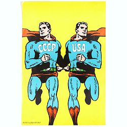
CCCP/USA, 1966
Original 1968 Cold War Superman Style Poster by Roman Cieslewicz (1930-1996). Published by Georges Fall, Paris. Printed by Serg, Paris.In 1968 the Parisian left-wing ar...
Place & Date: Serg, Paris, 1968

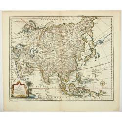
A new & accurate map of Asia, Drawn from the most approved modern maps & charts / by Thos. Bowen.
The map is of interest for the use of Sea of Korea, the sea between Korea and Japan.Detailed map of Asia from Saudi Arabia, Persia, Russia, India, China, Japan to Southea...
Place & Date: London, J.Cooke, 1777-1778
Selling price: $600
Sold in 2023