Browse Listings in Australia & Oceania
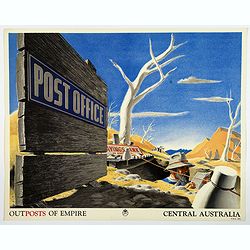
Outposts of Empire. Central Australia.
A large colored lithograph by John Vickery (1906-1983), he was an Australian artist. He worked in the fields of painting, illustration and advertising. He is the only Aus...
Place & Date: London, ca 1937

Histoire Socialiste.
Text includes “Imp. Centre de Propagande, des Républicains Nationaux, 102, rue Amelot, Paris (XIe), ou l’on peut se procurer cette affiche. Cette affiche ne peut êt...
Place & Date: Paris, 1931

Carte de L'Archipel de La Recherche a la partie Occidentale de la Terre de Nuyts. . .
A large and detailed chart of the southern West Australian coast centered on the region of Esperance and the surrounding islands.Terre de Nuyts is the name that was forme...
Place & Date: Paris 1807

Paskaerte Zynde t'Oosterdeel Van Oost Indien, met alle de Eylanden daer ontrendt geleegen van C. Comorin tota aen Iapan.
An eye-catching chart of Pieter Goos' sea chart of Australia, Southeast Asia, China, Japan, Korea and India. The chart shows the regions from Cape Comorin (Southern India...
Place & Date: Amsterdam, 1669
![[Lot of Five Pacific Brand crate labels]](/uploads/cache/45706-250x250.jpg)
[Lot of Five Pacific Brand crate labels]
Five fruit crate label for Pacific Brand, showing a lemon and a map of the Pacific Ocean, centered on Hawaii and including a part of California and Asia, with also Austra...
Place & Date: Santa Barbara, 1917
![Terre de Diemen. Tombeaux des naturels. [plate XVI]](/uploads/cache/46279-250x250.jpg)
Terre de Diemen. Tombeaux des naturels. [plate XVI]
An aboriginal campfire, near the ruins of an old wooden fence, and a dead tree, after the original sketches by Lesueur, from Voyage de découvertes aux terres Australes b...
Place & Date: Paris, 1824

Kaart Van Nieuw Zeeland in de Jaaren 1769 en 1770 bezogt door den Luitenant J. Cook met het Schip De Endeavour.
A uncommon issue of this key map of New Zealand from the Dutch edition of Cook's map of New Zealand, published in 'Reize rondom de Waereld door James Cook', a Dutch editi...
Place & Date: Leyden, Amsterdam & The Hague: Honcoop, Allart & van Cleef, 1795-1801
![[Collection of six maps of Australia and New Zealand.]](/uploads/cache/48412-250x250.jpg)
[Collection of six maps of Australia and New Zealand.]
Collection of maps including 6 engraved maps by 19th century German, French and English cartographers depicting Australia and New Zealand.This made to order atlas contain...
Place & Date: Germany, 1832-1852