Browse Listings

Karte von Katay od. dem Reiche Kin, zur Geschichte von Jenghiz Khan. Aus dem Englischen.
The map is of interest for the use of East Sea, the sea between Korea and Japan, here called "Meer von Corea".Copper engraving, hand colored in outline and wash...
Place & Date: Leipzig, Schwabe, ca. 1750
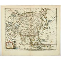
A new & accurate map of Asia drawn from actual surveys. . .
An excellent early engraving of Asia. Curious shape for Japan, with a large island north called Yeso and a coastline marked De Gamma's Land. Numbered "No 52."; ...
Place & Date: London, 1747

Siberia & Central Asia.
This map covers the eastern section of Russia as well as China, Japan, Korea, India and Tibet. The map is of interest for the use of Sea of Corea, the sea between Korea a...
Place & Date: Boston, 1835

Quarta pars Brabantiae cujus caput Sylvaducis.
A good and dark impression in strong original colors.The third state. The coat of arms of Brabant and 's-Hertogenbosch appears on the map. The municipal arms in the colum...
Place & Date: Amsterdam, 1645

Pascarte van Europa Beginnende vande Canael tot aen Spitbergen, en van Ysland tot aen Nova Zemla . . .
An eye-catching chart of northern Europe with a coastline from northern Russia to the Dutch English Channel in the south. Good detail on Iceland. North to the top.In the ...
Place & Date: Amsterdam, after 1666

(upper sheets only) Asia According to the Sieur D'Anville Divided into its Empires, Kingdoms and States Showing the European Settlements in the East Indies and all the New Discoveries made by the Russians, the Dutch and the English . . . 1772
Highly detailed map of Russia, including Turkey, China and Korea. Based on the cartography of the famous French cartographer Jean Baptiste Bourguignon d' Anville. Only th...
Place & Date: London, 1772
![[No title - Daniel's Dream map]](/uploads/cache/34784-250x250.jpg)
[No title - Daniel's Dream map]
Wood block print engraved by the famous engravers Jost Amman and Virgil Solis - with their initials in lower bottom of the map. This somewhat curious map of Europe, Afric...
Place & Date: Cologne, ca. 1564
![[City Of New York and Environs].](/uploads/cache/27530-250x250.jpg)
[City Of New York and Environs].
A very decorative bird's-eye view of Manhattan, Brooklyn, and part of New Jersey. Manhattan Island from the southwest is surrounded by the Hudson, Harlem, East River, and...
Place & Date: New York, 1875

New York Ferry Boat. (Bac à vapeur de New York).
A very decorative print showing the New York Ferry Boat "Fulton," published by Currier & Ives. The Ferry boat "Fulton" sails to the right. A singl...
Place & Date: New York, ca. 1875

Map of Russia and Poland.
Charming, folding map of Russia, Poland and Baltic States, still in its original publisher's blind stamped linen wrapper with yellow label. With yellow advertisements at ...
Place & Date: London, ca. 1894

Fokien Imperii Sinarum Provincia undecima.
The province of Fokien lies opposite Taiwan and south of the region described in the above map. The coast is shown from Wen-zhou in the north to Fu-zhou and as far south ...
Place & Date: Amsterdam, 1660

Carte du Mexique et des Etats Unis d'Amérique...
A later edition of De l'Isle's foundation map of 1703, is widely regarded as one of the most influential maps in the history of American Cartography. This updated version...
Place & Date: Paris, 1783

A Map of the most Inhabited part of New England containing the Provinces of Massachusetts Bay and New Hampshire, with the Colonies of Connecticut and Rhode Island.
A copper engraving in four sheets, published in Georges Louis Le Rouge, in his "Atlas Ameriqua in Septentrional Contenant les details des differentes provinces, de c...
Place & Date: Paris, 1777

Parliamentary Papers - Foreign Office - Annual Series - Diplomatic and Consular Reports on Trade and Finance.
Very scarce - Only for the British Parliament and the British Crown printed - and not for the trade! Accounts about the Korean country during the time span of the last th...
Place & Date: London, Harrison and Sons, 1882-1906

Hundeliebhaberey.
Engraved by Joseph Stöber, (born in Vienna 13. June 1768, died 12 March 1852) after design of Matthäus Loder (1781-1828). From Castelli, "Zerrbilder menschlicher T...
Place & Date: Wien, 1818
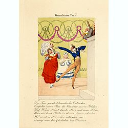
Grimafsirter Tanz.
Engraved by Joseph Stöber, (born in Vienna 13. June 1768, died 12 March 1852) after design of Matthäus Loder (1781-1828). From Castelli, "Zerrbilder menschlicher T...
Place & Date: Wien, 1818

Modesucht.
Engraved by Joseph Stöber, (born in Vienna 13. June 1768, died 12 March 1852) after design of Matthäus Loder (1781-1828). From Castelli, "Zerrbilder menschlicher T...
Place & Date: Wien, 1818
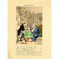
Vogel Liebhaberey.
Engraved by Joseph Stöber, (born in Vienna 13. June 1768, died 12 March 1852) after design of Matthäus Loder (1781-1828). From Castelli, "Zerrbilder menschlicher T...
Place & Date: Wien, 1818

Frefser.
Engraved by Joseph Stöber, (born in Vienna 13. June 1768, died 12 March 1852) after design of Matthäus Loder (1781-1828). From Castelli, "Zerrbilder menschlicher T...
Place & Date: Wien, 1818
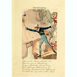
Schmetterlingsfang.
Engraved by Joseph Stöber, (born in Vienna 13. June 1768, died 12 March 1852) after design of Matthäus Loder (1781-1828). From Castelli, "Zerrbilder menschlicher T...
Place & Date: Wien, 1818
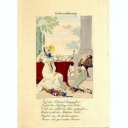
Liebeserklärung.
Engraved by Joseph Stöber, (born in Vienna 13. June 1768, died 12 March 1852) after design of Matthäus Loder (1781-1828). From Castelli, "Zerrbilder menschlicher T...
Place & Date: Wien, 1818
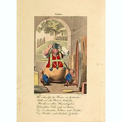
Säufer.
Engraved by Joseph Stöber, (born in Vienna 13. June 1768, died 12 March 1852) after design of Matthäus Loder (1781-1828). From Castelli, "Zerrbilder menschlicher T...
Place & Date: Wien, 1818
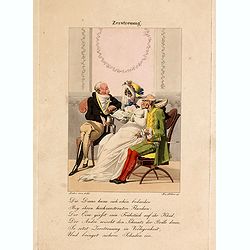
Zerstreuung.
Engraved by Joseph Stöber, (born in Vienna 13. June 1768, died 12 March 1852) after design of Matthäus Loder (1781-1828). From Castelli, "Zerrbilder menschlicher T...
Place & Date: Wien, 1818

Siberie ou Russie Asiatique, Tartarie Chinoise, Pays des Eluts et Isles du Japon.
Map of the Kamchatka peninsula, Russian Far East., Korea, Japan, with Hokkaido labeled "Terre del Jeso".By C. F. Delamarche, successor of Robert de Vaugondy, Ge...
Place & Date: Paris, 1794 - 1806

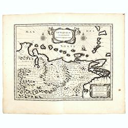
Il Cuscho citta principale della provincia del Peru.
A very desirable and scarce item of this decorative and early bid's-eye town-plan of the Inca city of Cuzco. Several figures shown inside the city walls and on the hillsi...
Place & Date: Lyons, 1564

L'Asie divisée en ses principaux Etats..
Finely and crisply engraved map of Asia, decorated with an ornamental title cartouche in the lower-left corner. The map is of interest for the use of Mer de Corée for th...
Place & Date: Venice, 1776 - 1784
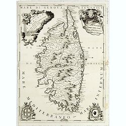
Isola di Corsica, Dedicata all' Em;mo e Rmo: Principe, il Sr. Cardinale Carpegna, Vicario di Sua Santita. . .
One of the most decorative maps of Corsica, with in the upper right, a draped fabric that bears the map's scales is dressed with two angels, one holding the cross, a coat...
Place & Date: Venise, 1692

Nieuwe Wassende Graadige Pas-kaart van de Kust van Guinea en Brasilia.
Rare two-sheet sea chart of the coasts of Brazil, West Africa and South Africa, published by Johannes Van Keulen (the younger), circa 1720.The chart shows the western coa...
Place & Date: Amsterdam, 1751

Novissima et Accuratissima Totius Americae Descriptio.
Second state of Visscher's map of the Americas, this decorative map greatly influenced the cartography of the Americas both geographically and artistically.Although it di...
Place & Date: Amsterdam, 1677
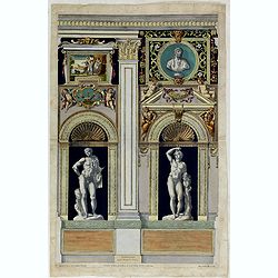
Tabula IV sequitur Farnesiana Posticus.
Ornamental representation of Temple St. Mariae in Rome by Petrus Aquila (1650-1692), after Annibale Carracci. Inscribed in the plate. "Petrus Aquila delin at sculp. ...
Place & Date: Rome, 1660

Riga metropolis Livoniae.
A spectacular panoramic of Riga, with legends numbered from a-z and 1-16 in German. With the title in a banderol.After a design by Friedrich Bernhard Werner (1690-1776) ...
Place & Date: Augsburg, ca. 1720

Norimberga.
A spectacular panoramic of Nuremberg, with legends numbered from 1-39 in German. With the title in a banderol.After a design by Friedrich Bernhard Werner (1690-1776) who...
Place & Date: Augsburg, ca. 1720

Nuova carta dell' Imperio della Chia e dei Paesi circonvicini. / Nueva carta de l'Impario de la Quina.
The map is of interest for the use of Mar di Corea" and "Mar Setentrionale del Giapone" in the sea between Korea and Japan.Rare early edition of Albrizzi's...
Place & Date: Venice, 1740

Nova Totius Terrarum Orbis Geographica..
The first of four states of the map. French text on verso. One of the most beautiful world maps ever engraved and one of the most influential in promulgating the Californ...
Place & Date: Amsterdam, 1630-1633
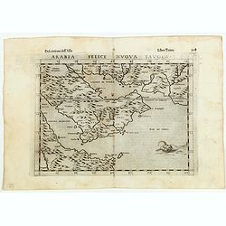
Arabia Felice Nuova Tavola.
Fine early map of Arabian peninsula, being one of the earliest modern maps of the region.Girolamo Ruscelli first published the map in his "La Geographi di Claudio To...
Place & Date: Venice, 1598
Les Gens de Justice. - Comme je vous ai bien dit vertement votre fait !
Second state (of 2), with text. From "Les Gens de Justice". Text below image : - Comme je vous ai bien dit vertement votre fait !. . . - Mais aussi, que je vous...
Place & Date: Paris, 1845-1848
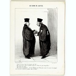
Les Gens de Justice. - Plaidez, plaidez . . . ça sera un bon tour à jouer à votre voisin. . .
Second state (of 2), with text. From "Les Gens de Justice". Text below image : - Plaidez, plaidez . . . ça sera un bon tour à jouer à votre voisin . . . vous...
Place & Date: Paris, 1845-1848

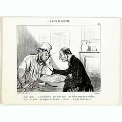
Les Gens de Justice. - Mr. le juge de paix a rendu sa décision, le sparties sont censées conciliées.
Second state (of 2), with text. From "Les Gens de Justice". Text below image : - Mr. le juge de paix a rendu sa décision, le sparties sont censées conciliées...
Place & Date: Paris, 1845-1848

Les Gens de Justice. - Mr. l'avocat a rendu pleine justice au rare talent déployé par le ministère public . . .
Second state (of 2), with text. From "Les Gens de Justice". Text below image : - Mr. l'avocat a rendu pleine justice au rare talent déployé par le ministère ...
Place & Date: Paris, 1845-1848
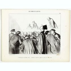
Les Gens de Justice. - L'avocat qui se trouve mal - dernière ressource quand la cause est bien malade.
Second state (of 2), with text. From "Les Gens de Justice". Text below image : - L'avocat qui se trouve mal - dernière ressource quand la cause est bien malade...
Place & Date: Paris, 1845-1848
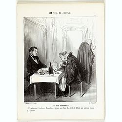
Les Gens de Justice. - Au café d'Aguesseau.
Second state (of 2), with text. From "Les Gens de Justice". Text below image : - Au café d'Aguesseau. En attendant l'audience, Démosthéne déjeune aux frais ...
Place & Date: Paris, 1845-1848
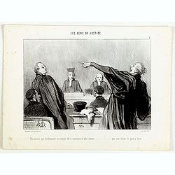
Les Gens de Justice. - Un avocat qui éviemment est rempli de la conviction la plus intime . . .
Second state (of 2), with text. From "Les Gens de Justice". Text below image : - Un avocat qui éviemment est rempli de la conviction la plus intime . . . que s...
Place & Date: Paris, 1845-1848
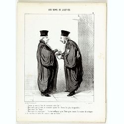
Les Gens de Justice. - Comme je vous ai bien dit vertement votre fait! . . .
Second state (of 2), with text. From "Les Gens de Justice". Text below image : - Comme je vous ai bien dit vertement votre fait! . . . - Mais aussi, je vous ai...
Place & Date: Paris, 1845-1848

The Crimea, chiefly from surveys made by order of the Russian government. . .
Map of Crimea and the Sea of Azov. In lower right corner two inset maps showing Sebastopol inlet and harbour and a second one with the Black Sea. This second maps shows t...
Place & Date: London, 1854

Poli Arctici, et circumiacentium terrarum descriptio novissima. . .
A re-issue of the Hondius' plate. A particularly decorative map of the North Pole with Iceland. Several Dutch names in Labrador. The toponymy in Canada reflects the conti...
Place & Date: Amsterdam, 1660

Allerneuester geographisch- und topographischer Schau-Platz von Africa und Ost-Indien. . .
An early issue of this important book by Johann Wolfgang Heydt's describing the Dutch factories, settlements and stations at the hands of the Dutch East India Company in ...
Place & Date: Wilhermsdorf, Tetscher u. Nürnberg, Homanns Erben, 1744

Carte générale de L'Empire Ottoman en Europe et en Asie dressée par Henri Kiepert . . .
Large School wall map of Turkish Empire printed in chromo-lithography. Published by Dieter Reimer and printed by Ferdind Barth in Berlin. This rare map has two insets in ...
Place & Date: Berlin, Verlag von Dietrich Reimer, 1867

Wandkarte von Europa von H.Berghaus. . .
Large wall map of Europe printed in chromo-lithography. Prepared by Heinrich Berghaus and published by Justus Perthes in Gotha.Heinrich Berghaus, with support of Alexande...
Place & Date: Gotha, Perthes, ca.1885

Imperii Sinarum nova descriptio.
Schenk and Valk's rare early 18th century issue of Janssonius milestone map of China, Korea and Japan after Martino Martini. Engraved by Johannes van Loon. The overall ba...
Place & Date: Amsterdam, ca. 1720
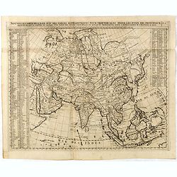
Nouvelle Carte De L'Asie Avec Des Tables Alphabetiques Pour Trouver Sans Peine Les Etats Des Principaux Princes De Cette Partie Du . . .
Chatelain's map of Asia. The title is in two lines across the map. On each side border appears an index to the map's contents.The map is of interest for the use of Mer Or...
Place & Date: Amsterdam, 1719
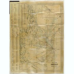
Plano de los Ferro-Carriles de Republica Argentina 1902.
Folding rail road map of Argentina, with inset of Buenos Aires in upper right corner.
Place & Date: Buenos Aires, ca. 1902

Vue perspective de la grande Ceremonie du Couronnement de l'Empereur de la Chine.
So-called optical print illustrating the crowning of the Chinese emperor. It shows the throne at the center.Mondhare was a well-known publisher of optical prints, establi...
Place & Date: Paris, 1761

Americae Sive Novi Orbis, Nova Descriptio.
This is the second copperplate of Ortelius' map showing the western hemisphere, showing the prominent bulge in the South American coastline. An important map because of i...
Place & Date: Antwerp, 1579
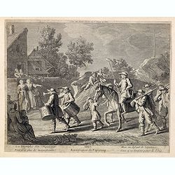
MARS Rejouissances du Papeguay. Les Triomphes d'un conquerant
Etching published by Louis Charles Desnos (1725-1805) with address of rue St.Jacques au Globe. He is also known for his output of wall maps and atlases.
Place & Date: Paris, 1782

Kaartje van Asia. . .
Attractive and rare map of Asia. From Atlas Portatif . With a curious and oversized Hokkaido. The map is of interest for the use of Corease Zee for the sea between Korea ...
Place & Date: Deventer, 1742

Kiepert's Physikalische Wandkarten IV. ASIEN. . .
Wall map of Asia printed in chromo lithography. Published by "Stich und Druck der lith. Anst. Von Leopold Kraatz in Berlin". Physical map showing the Asian cont...
Place & Date: Berlin, D. Reimer, 1873

Wandkarte des Deutsches Reiches zum Schul und Comptoir-Gebrauch. . .
School wall map of Germany, Poland, Low Counties, Bohemia printed in chromo lithography with contemporary hand coloring to borders. Published by "Stich und Druck der...
Place & Date: Berlin, Dieter Reimer, 1878

Le Chantier d'Amsterdam.
Decorative lithography representing the head quarters of the V.O.C. and shipyard in Amsterdam. The building serves nowadays as the Maritime Museum. After a painting by A....
Place & Date: Brussels, J. B. A. Jobard, 1825

ARMENIEN. Costumes de l'Empire Ottoman 9.
A beautiful hand colored lithograph of an Armenian published in the French work "Galerie Royale de Costumes peints d´après nature par divers artistes et lithograph...
Place & Date: Paris, Chez Aubert & Cie., 1842-1848

Paraguay o Prov. de Rio de la Plata cum regionibus adiacentibus Tucuman et Sta. Cruz de la Sierra.
Blaeu's map of the Rio de la Plata region of South America. Originally engraved for Jodocus Hondius II, at his death in August 1629 this map was, among 39 other copper pl...
Place & Date: Amsterdam, 1634
Venezuela cum parte Australi Novae Andalusiae.
German text on verso. A finely engraved, decorative map of Venezuela. The islands of Trinidad and Tobago, Margarita, Aruba, and Curaçao are shown. With a decorative titl...
Place & Date: Amsterdam, 1634

Novus XVII Inferioris Germaniae Provinciarum Typus.
Willem Blaeu published this map in 1608 as a wall map with figured borders. When later, in 1630 he needed a general map of the Netherlands for his first atlas, the Append...
Place & Date: Amsterdam, 1634
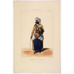
AFGHAN de CABOULE. Costumes Persans 8.
A beautiful hand colored lithograph of an elegant Afghan from Kabul published in the French work "Galerie Royale de Costumes peints d´après nature par divers artis...
Place & Date: Paris, Chez Aubert & Cie., 1842-1848

DANSEUSE. Costumes Persans 9.
A beautiful hand colored lithograph of an elegant dancing girl from Persia published in the French work "Galerie Royale de Costumes peints d´après nature par diver...
Place & Date: Paris, Chez Aubert & Cie., 1842-1848
![[No title] 'Daniel's Dream Map' or 'Wittenberg World Map'.](/uploads/cache/34785-250x250.jpg)
[No title] 'Daniel's Dream Map' or 'Wittenberg World Map'.
Wood block print engraved by the famous engravers Jost Amman and Virgil Solis - with their initials in lower bottom of the map. This somewhat curious map of Europe, Afric...
Place & Date: Cologne, ca. 1564

Tablaeu de l'Univers premiere partie/ .. seconde partie.
Uncommon and interesting manual containing a double hemisphere world map (with fine outer decoration and showing an imagined great sea in West America, easily the size of...
Place & Date: Luik, Belgium, 1784

Nieuwe Kaart van het Eyland Sumatra..
Fine chart depicting the Island of Sumatra and the southern coasts of Malaysia from Quedo to Johore. North is orientated to the left of the page. Singapore is probably id...
Place & Date: Amsterdam, 1726

Nieuwe Caart der Eylanden van Banda.
Decorative map of the Banda Islands.François Valentijn (1666-1727), a missionary, worked at Amboina from 1684 to 1694 and 1705 to 1713 and travelled extensively in the V...
Place & Date: Amsterdam, 1726

Russia & Poland.
Charming, folding map of Russia and Poland, giving a detailed overview of Europe from Baltic to Caspian Sea. Railways and rivers prominently delineated.In lower left a ke...
Place & Date: London, ca. 1890

Standford's map of the empires of China and Japan with the adjacent parts of the Russian Empire, India, Burma &c.
Charming, folding map of China and Japan with the adjacent parts of the Russian Empire, India, and Burma. A key identifies railway lines in red, projected railway lines i...
Place & Date: London, ca. 1911
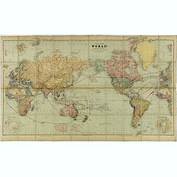
A Chart of the World on Mercator's Projection Shewing the Principal Ocean Steam Routes, the Submarine Telegraphs &c.
Charming, folding world map on Mercator's projection showing extensive steam routes and underground and undersea telegraph cables. The map is annotated in blue and red wi...
Place & Date: London, ca. 1890

Tabula Americae Specialis Geographica Regni Peru, Brasiliae, Terra Firmae & Reg: Amazonum, Secundum relationes de Herrera, de Laet & PP d Acuña & M. Rodriguez . . .
A good and clean copy of Homann's map of the northern part of South America. The map is on the Valley of the Amazon and delineates the Amazon and its labyrinth of tributa...
Place & Date: Nuremberg, 1728

Typus Geographicus Chili Paraguay Freti Magellanici &c.
Detailed map covering the southern part of the continent based on the cartography of Delisle and the information gleaned from the voyages of Brouwer, Narbouroug and Beauc...
Place & Date: Nuremberg, 1750
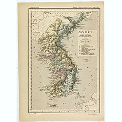
Carte de la Corée d'après la Carte du Dictionnaire coréen-français par les Missionnaires de Corée. . .
Map of Korea called "Corée", which was produced by the French organization Mission Etrangères de Paris (MEP) in 1880. Supposedly, the map was based on Father ...
Place & Date: Paris, 1880

Le Japon.
The map is of interest for the use of Mer de Corée, for the sea between Korea and Japan. Small detailed map of Japan and Korea. Dated 1749. A note next to island &quo...
Place & Date: Paris, 1749

Map of Louisiana from D'Anville's Atlas.
This map presents a highly detailed treatment of the region from Cabo Del Norte to the Apalachiola River, centered on the mouth of the Mississippi and extending inland to...
Place & Date: London, 1788

Americae Pars Magis Cognita. Chorographia nobilis & opulentae Peruanae Provinciae, atque Brasiliae, . . . MDXCII
First state. Although a map of South America it does include much of what is now the southern United States. There are two elaborate, strap-work cartouches with the one a...
Place & Date: Frankfurt, 1592
![[Portrait] Johannes Baptista Homann . . .](/uploads/cache/36599-250x250.jpg)
[Portrait] Johannes Baptista Homann . . .
Stunning full portrait of the Imperial Geographer of the Holy Roman Empire, Johann Baptist Homann (1664-1724) who was born in the Bavarian town of Kammlach. Educated at a...
Place & Date: Nuremberg, c.1740

Nuevo plano de la ciudad de Buenos Aires y parte del partido de avellaneda . . .
A rare detailed city plan of Buenos Aires prepared in 1912 by Ernesto Escalante. The plan depicts the city from the Partido de Avellaneda and the Villa Riachuelo to the R...
Place & Date: Buenos Aires, 1912
![XIX. Venatio Elephantum in Pegu. [How elephants are caught in Pegu]](/uploads/cache/29795-250x250.jpg)
XIX. Venatio Elephantum in Pegu. [How elephants are caught in Pegu]
How elephants are caught in Pegu. The king of Pegu had a particular method of transporting elephants. He had a great enclosure built of strong wooden posts, with a trap d...
Place & Date: Frankfurt, 1599