Browse Listings
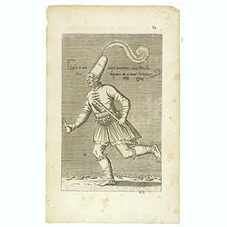
Habit et Manière ancienne des Peiches ou Laquais du Grand Seigneur. (14)
Sought-after copper engraved plate taken from Laonikos Chalcocondyle’s "L'histoire de la décadence de l'empire grec et establissement de celuy des Turcs." by...
Place & Date: Paris, Mathieu Guillemot, 1650
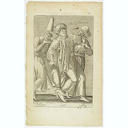
Les Yurongnes. (18)
Sought-after copper engraved plate taken from Laonikos Chalcocondyle’s "L'histoire de la décadence de l'empire grec et establissement de celuy des Turcs." by...
Place & Date: Paris, Mathieu Guillemot, 1650
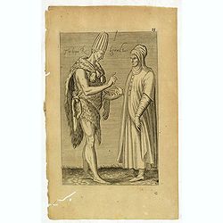
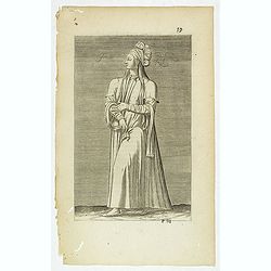
Torlaqui Religieux Turc. ( 25 )
Sought-after copper engraved plate taken from Laonikos Chalcocondyle’s "L'histoire de la décadence de l'empire grec et establissement de celuy des Turcs." by...
Place & Date: Paris, Mathieu Guillemot, 1650
(Grand dame Turque. 45)
Sought-after copper engraved plate of a woman from Turkey. Plate from Laonikos Chalcocondyle’s "L'histoire de la décadence de l'empire grec et establissement de c...
Place & Date: Paris, Mathieu Guillemot, 1650
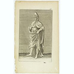
Femme Persienne. (59)
Sought-after copper engraved plate of a woman from Persia. Plate from Laonikos Chalcocondyle’s "L'histoire de la décadence de l'empire grec et establissement de c...
Place & Date: Paris, Mathieu Guillemot, 1650

Grande Pologne et Prusse avec les frontières de la Misnie, Lusace, Moravie et Lithuanie.
Detailed map of Poland and Prussia. Published by Pieter van der Aa who published a.o. "Naauwkeurge versameling der gedenkwaardigste zee- en land-reysen", a seri...
Place & Date: Leiden, 1729

Nansenbushu bankoku shoka no zu.
This map is a great example of Japanese world maps representing Buddhist cosmology with real-world cartography. It is the earliest one and - therefore - the prototype for...
Place & Date: Kyoto, (Hoei 7 = Year of the Tiger) 1710

Iunan, Queichev, e Quangsi Provincie della Cina. . .
A beautiful map depicting the area of Beijing with decorative title cartouche and scale cartouche. Information about the area at the top of the map.The remarkable Vincenz...
Place & Date: Venice, 1690

De Stadt Jerusalem.
Plan of ancient Jerusalem from a Dutch bible after Villalpando. The print is in contemporary colors, which is extremely rare for a plate like this. Lower left the Temple ...
Place & Date: Amsterdam, 1710

Venise. 1700
Extremely rare panoramic broad sheet panoramic town-view of Venice with underneath in letter press a description of the town's history. The view measures more than 1 mete...
Place & Date: Paris, 1699

Landgraviatus Alsatiae tam superioris..
Alsace, in the far north-eastern corner of France, stands out from other French wine regions thanks to its strong Franco-Germanic influences. Alsace is the only French wi...
Place & Date: Nurenberg, 1710
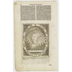
Maria De Medices D. G Galliae et Navarrae Reg. Uxor Henr. IIII.
The engraving depicts a half length oval portrait of Marie de' Medici, queen consort of France .Nicolaes de Clerck (de Klerc) was active as engraver and publisher in Delf...
Place & Date: Amsterdam, Cloppenburch, 1621

Shinkan Nagasaki no Dzu.
The oldest of these so-called Nagasaki pictures (Nagasaki-zu) were two panoramic prints by the artist Chikujuken that served as guides to the city of Nagasaki for visitor...
Place & Date: Nagasaki, 1801

Parte orientale della China.. / Parte occidentale della China. (2 sheets)
The map depicts the eastern part of China with Korea -correctly- as a peninsula. Formosa is included as well. Japan is partly visible i.e. the area of Yamaguchi, strait K...
Place & Date: Venice, 1695
![[Printed on silk] Nieuw Wassende Graaden Paskaart Vertoonende alle de bekende Zeekusten en Landen op den geheelen Aard Boodem of Werelt door Gerard van Keulen. . .](/uploads/cache/31640-250x250.jpg)
[Printed on silk] Nieuw Wassende Graaden Paskaart Vertoonende alle de bekende Zeekusten en Landen op den geheelen Aard Boodem of Werelt door Gerard van Keulen. . .
A very scarce and beautiful chart on Mercator's projection printed on silk. With the name of Gerard van Keulen and the privilege. The map shows great interior detail, inc...
Place & Date: Amsterdam, 1728

Hedendaegsche Historie of tegenwoordige staet van alle volkeren 1 deel. (Volume 1 - China, Japan, Phillippines, Moluccas)
This provides an interesting illustrated description of China, Japan, the Phillippines, Moluccas. Including a map of China, Korea, and Japan, with the Sea between Korea a...
Place & Date: Amsterdam, 1734

Citta, porto, e rada di Brest, e . . . Nella Bretagna . . .
A beautiful and rare map of Bretagne. In top right an inset with the town of Brest.The remarkable Vincenzo Coronelli (1650-1718), encyclopaedist, geographer, inventor and...
Place & Date: Venice, 1690

Languedoc - Foix Roussillon.
Very decorative, informative map of Languedoc - Foix Roussillon region in south eastern France. Including the towns of Carcassonne, Montpellier, Albi, Toulouse, etc.The m...
Place & Date: France, 1943

Guyenne - Gascogne.
Very decorative, informative map of Guyenne and Gascogne region in France. The map is filled with buildings, animals, figures and two locals. With a large compass rose in...
Place & Date: France, 1943
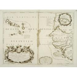
Bocche del Fiume Negro et Isole di Capo Verde.
Double-page engraved map of the Cape Verde Islands and part of the coast of Senegal, with large decorative cartouche. One with inset of the island Goree. During three cen...
Place & Date: Venice, 1690

Le Duché d'Aiguillon Tracé Par le Sr. Du Vall.
Home of the "Cahors” This AOC is the most famous of the sub-regions and home to the popular variety Malbec. These inky wines have been adored for centuries, especi...
Place & Date: Amsterdam, 1650

Premislia celebris russiae civitas.
RARE only included in part VI of his town book. Bird's-eye of Przemysl in Poland. Frans Hogenberg (1535 Mechelen - Cologne 1590) was a copper engraver and etcher. Georg B...
Place & Date: Cologne, 1618

Isola d'Oleron, nella piaggie occidentali della Francia.
A beautiful and rare map showing île d'Oleron.The remarkable Vincenzo Coronelli (1650-1718), encyclopaedist, geographer, inventor and Doctor of Theology, was citizen of ...
Place & Date: Venice, 1690

Nazareth.
Decorative view of Nazareth, below a decorative cartouche with numbered key and surrounded by 2 cherubins. Taken from a very rare travel book by Anthonius Gonsales, "...
Place & Date: Antwerpen, Michiel Cnobbaert, 1673
![Rama. [Ramah]](/uploads/cache/30789-250x250.jpg)
Rama. [Ramah]
Town plan of Ramah, about 5 miles (8 km) from Jerusalem and near to Gibeah. Below a decorative cartouche with numbered key and surrounded by 2 cherubins.Taken from a very...
Place & Date: Antwerpen, Michiel Cnobbaert, 1673
![Via Bethleem. [The route from Jerusalem to Bethlehem ]](/uploads/cache/30800-250x250.jpg)
Via Bethleem. [The route from Jerusalem to Bethlehem ]
The route from Jerusalem to Bethlehem. Below a lettered key. Taken from a very rare travel book by Anthonius Gonsales, "Hierusalemsche Reyse". The book describe...
Place & Date: Antwerpen, Michiel Cnobbaert, 1673

Het Canaal tusschen Engeland en Vranciick.
An eye-catching chart of the Channel.Pieter Goos (ca. 1616-1675) was one of the most important cartographers, engravers, publishers and print sellers of Amsterdam. His wi...
Place & Date: Amsterdam, after 1666

The town & harbour of Sevastopol with the batteries & approaches. . .
Rare colored linen backed map showing the harbour and town of Sevastopol, with soundings. In upper left corner a inset map (65x150mm) of the Black Sea. In bottom part a l...
Place & Date: London, March 27th, 1854

Forteresse Ile Ste Marguerite.
Nice drawing of a stronghold Ste Marguerite. The Île Sainte-Marguerite is the largest of the Lérins Islands, about half a mile off shore from the French Riviera town of...
Place & Date: France, Provence, after 1960

Carte de l'Ile de Java.
An inset plan of Batavia and clearly indicated rice fields, mountains, forests, towns in profile and even elephants suggest the wealth of detail found on this map. Modele...
Place & Date: Amsterdam, 1720

Il regno della China detto presentente Catay e Magnin. . .
A rare and decorative Italian map of China and Japan, with Japan closely modelled on the indented Cardim outline and Hokkaido, called Yuppi , shown as an Asian peninsula....
Place & Date: Rome, 1682

Japonia Regnum.
It is the first map to correctly show Korea as a peninsula. The rare Covens and Mortier issue of this important map of Japan and Korea, originally published by Blaeu. Thi...
Place & Date: Amsterdam, 1655 - 1720

Diverses cartes et tables pour la géographie ancienne, pour la chronologie et pour les itinéraires et voyages modernes.
Edition without date. Variant edition containing three parts : "Cartes géographiques dressées pour bien entendre les Historiens… / La Chronologie en plusieurs Ta...
Place & Date: Paris, l'Auteur, no date ca.1669

Carta geographica generalatus carlostatuensiscum adgacentibus confinis turcicis et venetis...
Fine and rare manuscript map of Croatia and the Dalmatian coast from the early eighteenth century. Oriented to the south the map details the Venetian, Austrian and Turkis...
Place & Date: Venice ?, c. 1700
Novus Atlas Absolutissimus... Die Wasser-Welt, oder See-Atlas.
Volume IX (Sea-Atlas) of the "Novus Atlas Absolutissimus". German text, letterpress title on slip within hand-colored engraved architectural border, heightened...
Place & Date: Amsterdam, Janssonius heirs, 1657 [after 1664

Moscovia urbs Metropolis totius Russiae Albae.
Detailed bird's-eye town-plan of Moscow from Janssonius' rare townbook. With a key (1-20) to important spots in town. The verso has French text and originates from Jansso...
Place & Date: Amsterdam, 1657

Cochin (today: Ernakulam)
Small but charming 18th water color on paper depicting Cochin (today : Ernakulam) was from 1500, when the first Portuguese fleet called on its port, a firm ally of the Po...
Place & Date: India? c.1750

Kancheu.
Charming 18th water color on paper depicting Kancheu. Probably made by a western artist visiting China.
Place & Date: c.1750

Nostre Dame de Lorette.
A very RARE panoramic of Lorette and the church, including a numbered legend in both lower corners.The plate is numbered in black pencil in upper right corner.Published ...
Place & Date: Paris c.1720

Tabula Ducatus Brabantiae.
Detailed map orientated west to the top.
Place & Date: Amsterdam, 1680

Histoire Naturelle, Civile, Et Ecclésiastique..'
First French edition, published by P. Gosse, J. Neaulme and B. Lakeman. The basic work on Japan from the second half of the 17th century when it was still forbidden for f...
Place & Date: Amsterdam, 1729
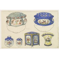
Designs for Porcelains with Chinese design.
In right hand side "Planche d'aquarelle N° 04509". and the numbers 11.103, 11.141, 11.142, 11,077, 11,101, 10,981. Original design created by the Sevres artist...
Place & Date: Desvres, 1905 - 1925

Designs for porcelain plate with Chinese design.
In right hand side "Planche d'aquarelle N° 06502". And the numbers 11.153, 11.154, 11.155. Original design created by the Sevres artist Gabriel Fourmaintraux (...
Place & Date: Desvres, 1905 - 1925

Designs for Porcelain ware with Chinese design.
In left hand side "Planche d'aquarelle N° 05501". Original design created by the Sevres artist Gabriel Fourmaintraux ( 1886 - ) at about 1910 to serve as guide...
Place & Date: Desvres, 1905 - 1925

Designs for two porcelain bowls with Chinese design.
With numbers 4.601, 4.818. In top "Planche N° d'ordre : 03004.Original design created by the Sevres artist Gabriel Fourmaintraux ( 1886 - ) at about 1910 to serve a...
Place & Date: Desvres, 1905 - 1925
![Aou, Tōkei. Kokugun Zenzu [Atlas of Provinces and Counties of Japan]. (volume 1 only)](/uploads/cache/63619-250x250.jpg)
Aou, Tōkei. Kokugun Zenzu [Atlas of Provinces and Counties of Japan]. (volume 1 only)
First edition. Very attractive early Japanese Atlas of detailed maps of Japanese regions compiled by six Japanese civilians in the eighth year (1837) of the Tenpō era (...
Place & Date: [Nagoya]: Tōheidō, Tenpō 8 = 1837

Designs for porcelain vase with Chinese motif.
With attractive pattern of a classic Chinese motif. In top "Planche d'aquarelle N° 04510" and the numbers 2,198. Original design created by the Sevres artist G...
Place & Date: Desvres, 1905 - 1925

Designs for porcelain vases with Chinese motif.
Hand colored design of 13 vases with attractive patterns of a classic Chinese motif. In right "Planche d'aquarelle N° 04004" and the numbers 7.404, 2.074, 8.93...
Place & Date: Desvres, 1905 - 1925
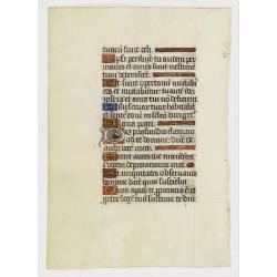
Leaf on vellum from a manuscript Book of Hours.
VERSO: one 2-line illuminated initial showing a bird in fine detail in liquid gold on colored ground, seven 1-line initials and line-fillers in same.RECTO: Seven 1-line i...
Place & Date: France, c. 1520
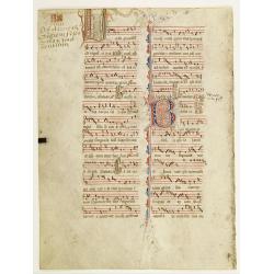
Leaf on vellum from an antiphonary.
A more than 600 years old antiphonary leaf, written in Besançon, in 1370. Musical notation on 4 bars, the staves are in red and the notes in black: numerous pen-flourish...
Place & Date: Besançon, 1370

Hemisphaerium Orbis Antiqui cumzonis circulis. . .
A chart showing the eastern hemisphere, including north eastern coast of Australia with, superimposed, climatic zones and planetary details. Surround by most decorative s...
Place & Date: Amsterdam, 1708

Veue de la Ville, et du Port de Calais, di côte de la terre.
Showing the town of Calais; landscape with, in the left foreground, group of cavalrymen led by an officer and going to right, at right two soldiers walking alongside a ca...
Place & Date: Paris, ca. 1680

Secunda etas mundi. Folium XIII.
Schedel's world map was based on the cartographic system of Claudius Ptolemy, the great second-century AD geographer whose scholarship formed the foundation for map produ...
Place & Date: Nuremberg, 12 July 1493

s'Lants Zee-Magazyn en Scheeps Timmer-werf.
Decorative view of the back yard of the formerly the V.O.C. warehouse and arsenal for the Admiralty of Amsterdam, now-a-days the Scheepvaartmuseum (Maritime Museum).The p...
Place & Date: Amsterdam, 1694

Gezicht van het Admiraliteits-Magazyn en Scheeps Timmerwerf.
Formerly the V.O.C. warehouse and arsenal for the Admiralty of Amsterdam, now-a-days the Scheepvaartmuseum (Maritime Museum). Taken from the "Atlas of Amsterdam"...
Place & Date: Amsterdam, 1780

Carte d'Europe . . .
Rare. Uncommon and decorative wall map of Europe, prepared by Clouet. With superb decoration including a wonderful rococo border with vignettes describing historical scen...
Place & Date: Paris, 1785-1788

A Perspective View of the Admiralty Office, Dock-Yard, Storehouses &c. at Amsterdam.
Decorative engraving giving good detail of the intense activity in the Amsterdam dockyards.Engraved for BANKES's New System of Geography
Place & Date: Amsterdam, 1780
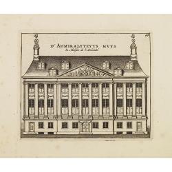
D' Admiralyteyts Huys - La maison de l'Amirauté.
Decorative print of the Admiralty House of the V.O.C., now-a-days Maritime Museum in Amsterdam.
Place & Date: Amsterdam, c.1720
Oostindische Zeemagazijn. & De Werf van Het Oostind. Zeemagazijn.
Two decorative lithographies on one sheet, illustrating the V.O.C. East Indian Arsenal and the naval shipyard.
Place & Date: Amsterdam, ca. 1840
!['S Lands Magazijn en Werf. [&] Het Oostindischehuis.](/uploads/cache/22713-250x250.jpg)
'S Lands Magazijn en Werf. [&] Het Oostindischehuis.
Two decorative lithographies on one sheet. View of the 'T Landts Magazyn , or 'Scheepvaartsmuseum' (Maritime Museum) on top. On the bottom the East Indian House , the hea...
Place & Date: The Hague, 1840
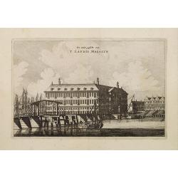
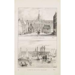
Een ander gesicht van 'T LANDTS MAGAZYN.
A decorative print of the 'T Landts Magazyn, formerly the V.O.C. warehouse and arsenal for the Admiralty of Amsterdam, now-a-days the Scheepvaartmuseum (Maritime Museum) ...
Place & Date: Amsterdam, 1663
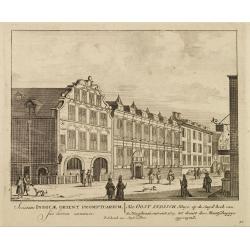
Het Oost Indisch Huys op de Suyd hock..
A decorative print of the East Indian House , the headquarters of the V.O.C., a place for meeting, trading and storage of spices and ship equipment.The maps and charts we...
Place & Date: Amsterdam, 1720

Vue du Magazin de la Compagnie des Indes Orientales. . .
So-called optical print of the formerly the V.O.C. warehouse and arsenal for the Admiralty of Amsterdam, now-a-days the Scheepvaartmuseum (Maritime Museum).In the eightee...
Place & Date: France, 1780

Portrait of Jan Maatzuiker.
Portrait of Jan Maatzuiker, Governor-General of the East Indies from 1653 till 1678. From Kok's Woordenboek . Engraved by Reinier Vinkees in 1790.
Place & Date: Amsterdam, 1790
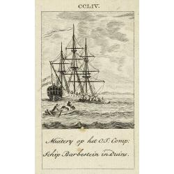
Muitery op het O:I: Comp. schip Barbestein in Duins.
Anonymous engraving of a mutiny of the VOC ship Barbestein .
Place & Date: Amsterdam c.1790

Nieuwe kaart van 't Koninckryk Bengale. . .
Rare map Bangladesh with the Ganges delta, including Calcutta. Giving great detail with trade routes, European trade settlements, etc. Prepared by Joh. Van Leenen who was...
Place & Date: Amsterdam, 1726
-250x250.jpg)
Lyste vande prysen der goederen ingekoft by de Kamer. . .
Rare price list of meat, bacon, wheat, rye, butter, cheese, olive oil, Spanish wines, Bordeaux, brandy etc.On front page in letter press Lyste Van de Pryfen der Goederen,...
Place & Date: Amsterdam, 1685

Vue de L'Hotel de Batavie. . .
A so-called optical print of Fatahillah Square in Jakarta, Indonesia, prepared for use in a light-box or an amusing light-show. This richly hand colored print is much per...
Place & Date: Augsburg, 1750
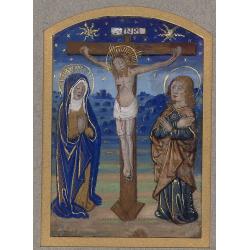
Miniature of The Crucifixion of Christ.
Page fragment from a Book of Hours with a miniature of the Cruxifiction with Saint Mary and Mary Magdalene in prayer in front of Jesus hung on the cross. This miniature c...
Place & Date: Paris, 1492 - 1494
![Venecie. [Venice] Foliu XLIIII](/uploads/cache/29716-250x250.jpg)
Venecie. [Venice] Foliu XLIIII
A very fine of Venice (192x525mm.) Verso a view of Padua. Schedel's view of Venice is one of the earliest obtainable views of the city. The view is based on the view of ...
Place & Date: Nuremberg, 12 July 1493

LA RUSSIE NOIRE ou POLONOISE qui Comprend les PROVINCES DE LA RUSSIE NOIRE de VOLHYNIE et de PODOLIE divisées en leurs Palatinats Vulgairement Connües sous le Nom D'VKRAINE ou PAYS DES COSAQUES.
Very rare map of the Ukraine and Poland, prepared by Sanson in 1675 in a third state, published by the heirs of Sanson, in Paris in 1706. The imprint changed to: Par les ...
Place & Date: Paris, 1706

La marca d'Ancona. Marchia Anconitana Picaenum olim dicta. . . Romae apud Joannem Orlandini formis Rome 1604.
A re-issue of the plate by Vicentium Luchinù of 1564 now with the address of Orlandini and the dates 1602 / 1604.Collector's item. A unique opportunity to acquire a fine...
Place & Date: Rome, 1604

Plan de la Baye de Ville Franche et de celle de St. Souspir.
An attractive chart centered on the Mediterranean. With scale and large compass-rose. Dated 1727, with the privilege of the King. From : Recueil des Plusieurs plans des p...
Place & Date: Marseille, 1730

Carte géologique détaillée. Beyrouth.
Geological or soil map showing part of Lebanon with Beyrouth, including in top a colored legend with signs of the different geological ages. Provenance : Fondation P. Fal...
Place & Date: Liban, Service geographique des F.F.L., 1945.

Nova Orbis Tabula in Lucem edita A.F.de Wit.
According to Shirley, De Wit's map is one of the most attractive of its time. The brilliant scenes in the corners combine images of the four seasons, the elements, and th...
Place & Date: Amsterdam, 1680
Tabula Russiae ex autographo, quod delineandum curavit Foedor filius Tzaris Boris desums... - Domino regionum Iueriae Kartalinie et Groefiniae Tzari etc: dedicata ab Heselo Gerardo M.DC.XIIII
A re-issue, by Willem Blaeu, of Hessel Gerritsz' rare and influential map of Russia. Dutch text on verso, extending west to east from Emden to Aspachan and north to south...
Place & Date: Amsterdam, 1635

Il Governo di Guascogna con porzione del Governo di Guienna.
Rare regional map of France of the Périgord, Guienne, Gascogne and the Béarn published by Carli Pazzini in Siena.
Place & Date: Siena, 1792

Gouvernement general de Champagne. . .
Fine map of Champagne with a decorative title and scale cartouche.Alexis-Hubert Jaillot (1632-1712), was a French cartographer. He joined the Sanson heirs and redrew Nico...
Place & Date: Amsterdam, 1692

Le comte d'Artois dresse sur les memoires les plus nouveaux. . .
Map showing the north of France, showing St Omer, and Arras, etc. The map notes Nicolas Sanson as the mapmaker and claims that the map was published by Alexis-Hubert Jail...
Place & Date: Amsterdam, 1693
![Bressia vulgo Bresse. [colored by Van Santen]](/uploads/cache/29235-250x250.jpg)
Bressia vulgo Bresse. [colored by Van Santen]
Title cartouche with putti and surveyor with surveying instruments. Upper right-hand corner Geneva, lower left Lyon and in the center Bourg-en Bresse. Upper right-hand co...
Place & Date: Amsterdam, 1650