Browse Listings

A Map and History of Peiping; formerly known as Peking; capital of provinces, princedoms and kingdoms since 1121 B.C. . .
The uncommon second edition of this very decorative and informative pictorial map of Beijing and surrounding areas whimsically illustrates the Forbidden City, essential e...
Place & Date: The Peiyang Press, Ltd. Tientsin-Peiping, 1936
![Schat-Kamer ofte konst der stuurlieden, behelzende een duidelyke onderwyzinge in de navigatie. . . [bound with] Tafelen bevattende De Sinussum, tangenten en Secanten. . . [bound with] Geographische Tadfel...](/uploads/cache/33112-250x250.jpg)
Schat-Kamer ofte konst der stuurlieden, behelzende een duidelyke onderwyzinge in de navigatie. . . [bound with] Tafelen bevattende De Sinussum, tangenten en Secanten. . . [bound with] Geographische Tadfel...
Schat-Kamer ofte konst der stuurlieden, behelzende een duidelyke onderwyzinge in de navigatie. . . [bound with] Tafelen bevattende De Sinussum, tangenten en Secanten. . ....
Place & Date: Amsterdam, J. v. Keulen en Zoonen, 1777

North Pacific.
Huge three sheet so-called Blue-back sailing chart of the Northern Pacific including China, Korea (with Matu Is. and Liancourt), Japan, Philippines, Kamchatka, Hawaii, Al...
Place & Date: London, 1868

Mappa Humoristico da Europa.
A really unusual and lovely map, published in Portugal at the outbreak of The Great War in 1914. This outbreak of war in Europe was the result of a complex sequence of ev...
Place & Date: Lisbon, 1914
![Schat-Kamer ofte konst der stuurlieden, inhoudende Een duidelyke onderwyzinge in de navigatie. . . [bound with] Geographische Tadfel vande Graaden.. Voornaamste Zee-haavens. . .](/uploads/cache/33114-250x250.jpg)
Schat-Kamer ofte konst der stuurlieden, inhoudende Een duidelyke onderwyzinge in de navigatie. . . [bound with] Geographische Tadfel vande Graaden.. Voornaamste Zee-haavens. . .
Rare and important manual originally prepared by Klaas de Vries and improved by Evert Floryn and S.Hollander of the "Schat-Kamer ofte konst der stuurlieden" (Tr...
Place & Date: Amsterdam, Wed. Gerard Hulst van Keulen, 1802

Le comte de Namur et partie des Duchez de Brabant. . .
Decorative map centered on Namen and including the towns of Liege, Leuven, Charleroi, Dinant, Luxemburg, etc. by François Jollain (ca. 1641 – 18 April 1704).Rare "...
Place & Date: Paris, c. 1692

Carte du Palatinat du Rhin.
Decorative "carte à figures"- map centered on Koblenz, Metz, Strasburg, Manheim and Heidelberg, with the river Rhine by François Jollain (ca. 1641 – 18 Apri...
Place & Date: Paris, ca. 1688

Campagne du Roi de Prusse de 1778 à 1779.
The book is illustrated with a two-sheet folding map "Carte d'une partie du Royaume de Bohême et de la Moravie ainsi que d'une partie de la Silésie". Prepared...
Place & Date: Geneva, Paris, Mérigot le jeune, 1784

Vaisseau du premier rang portant pavillon d'amiral.
Fine double-page engraved plate of a naval vessel, with the various parts of the ship numbered and identified. From Mortier's "Neptune François". From Mortier'...
Place & Date: Amsterdam, 1695
![[Europe, Eastern, Sarmatia, Ukraine]](/uploads/cache/33854-250x250.jpg)
[Europe, Eastern, Sarmatia, Ukraine]
Wood block printed map and one of earliest printed representation of Europe, Eastern, Sarmatia, Ukraine prepared L. Fries after Martin Waldseemüller.Based on the slightl...
Place & Date: Vienna, Trechsel, G., 1525 -1541
![.[Near east with Cyprus]](/uploads/cache/33857-250x250.jpg)
.[Near east with Cyprus]
Wood block printed map and one of earliest printed representation of Near east with Cyprus prepared by Martin Waldseemüller. Based on the slightly larger map from 1513 p...
Place & Date: Vienna, 1525 -1541
![.[India]](/uploads/cache/33861-250x250.jpg)
.[India]
Wood block printed map and one of earliest printed representation of India prepared by Martin Waldseemüller. Based on the slightly larger map from 1513 published in &quo...
Place & Date: Vienna, Trechsel, G., 1525 -1541
![.[Bangladesh, Burma, India, Thailand]](/uploads/cache/33867-250x250.jpg)
.[Bangladesh, Burma, India, Thailand]
Wood block printed map and one of earliest printed representation of Bangladesh, Burma, India, Thailand prepared Martin Waldseemüller. Based on the slightly larger map f...
Place & Date: Vienna, Trechsel, G., 1525 -1541
![.[Georgia (Republic), Sarmatia, Ukraine]](/uploads/cache/33870-250x250.jpg)
.[Georgia (Republic), Sarmatia, Ukraine]
Wood block printed map and one of earliest printed representation of Georgia (Republic), Sarmatia, Ukraine prepared by Martin Waldseemüller. Based on the slightly larger...
Place & Date: Vienna, Trechsel, G., 1525 -1541
![[India and China]](/uploads/cache/33875-250x250.jpg)
[India and China]
Wood block printed map and one of earliest printed representation of India and China prepared Martin Waldseemüller. Based on the slightly larger map from 1513 published ...
Place & Date: Vienna, 1525 -1541
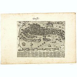
Venise (Venetia).
Extremely rare and detailed bird's-eye view of the town of Venice by Giacomo Lauro (active about 1584-1637), taken from "Heroico Splendore delle Città del Mondo&quo...
Place & Date: Rome, ca. 1642

Xantung, sinarum imperii provincia quatra.
A map of the northern province ‘Xantung’ of China after the Jesuit Martino Martini.Shows the Great Wall and is centered on the Bohai Sea, and the Shandong and Liaonin...
Place & Date: Amsterdam, ca 1660
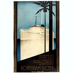
Rotterdam Lloyd, Royal Mail Line. La Méditerranée - L' Egypte - Ceylan - La Malaysie - Les Indes Néerlandaises - L' Australie - L' Indo-Chine - La Chine - Le Japon.
Johann von Stein made this iconic poster for the Rotterdam Lloyd in 1930. This is the rare French version for the tour from Rotterdam to Australia.Johann von Stein (Dutch...
Place & Date: Rotterdam, 1930
Very rare share in the Ostend Company. (4527)
Upper left hand corner share number 4527 in manuscript. In top emblem of the Ostend Company in copper engraving. Text: De Directeurs van de generale Keijserlijche- Indisc...
Place & Date: Antwerp / Ostend 1723

Plan de la rade de Macao (chine) Levé d'après les ordres mr. Rocquemaurel.
Very detailed chart of Macao and several of the surrounding Islands, and features numerous depth soundings throughout. Prepared by captain, Gaston de Rocquemaurel. Logo o...
Place & Date: Paris, c.1856 / 1863
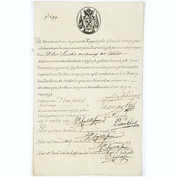
Very rare share in the Ostend Company. (299)
Upper left hand corner share number "299" in manuscript. In top emblem of the Company in copper engraving. Text: " De Directeurs van de generale Keijserlij...
Place & Date: Antwerp / Ostend, 1723

Novissima et Accuratissima Totius Americae Descriptio.
Second state of Visscher's map of the Americas, this decorative map greatly influenced the cartography of the Americas both geographically and artistically.Although it di...
Place & Date: Amsterdam, 1677

Imperii Sinarum nova descriptio.
Schenk and Valk's rare early 18th century issue of Janssonius milestone map of China, Korea and Japan after Martino Martini. Engraved by Johannes van Loon. The overall ba...
Place & Date: Amsterdam, ca. 1720

Kiepert's Physikalische Wandkarten IV. ASIEN. . .
Wall map of Asia printed in chromo lithography. Published by "Stich und Druck der lith. Anst. Von Leopold Kraatz in Berlin". Physical map showing the Asian cont...
Place & Date: Berlin, D. Reimer, 1873

Ignographia candiae tertia a turcis obsessae in lucem edita a F. de Wit.
A scarce broadsheet plan and view of Heraklion on one sheet: prospect 180 x 495mm, map 395 x 495mm., in the lower part a printed description "Abbildung der starken S...
Place & Date: Amsterdam, 1680
![Tabula electoratus Brandenburgici, Meckelenburgi, et maximae partis Pomeraniae, ex variis, famosissimisq[ue] auctoribus summo studio concinnata. . .](/uploads/cache/37545-250x250.jpg)
Tabula electoratus Brandenburgici, Meckelenburgi, et maximae partis Pomeraniae, ex variis, famosissimisq[ue] auctoribus summo studio concinnata. . .
Uncommon "carte à figures"- map engraved by the master engraver Abraham Goos and published by Claes Jansz. Visscher (1587-1652). Showing the part of western Po...
Place & Date: Amsterdam, 1630

Magnus Ducatus Finlandiae Auct. Andrea Bureo Succo.
The first printed survey map of Finland, composed by the Swedish cartographer Anders Bureus (1571-1661). The map was published in 1662 in the second volume of Joan Blaeu'...
Place & Date: Amsterdam, 1660

Palatinatus Rheni Nova et Accurata Descriptio.
Early state (1630) of Visscher's "carte à figures"- map of the German Rhine River Valley. Inset views of Frankfurt am Main, Mainz, Speyer, Worms and Heidelberg...
Place & Date: Amsterdam, 1630

China Veteribus Sinarum Regio.
Based on Jesuit surveys, the map represents the next major revision in the cartography of China after Ortelius' 1584 map. Korea, however, is still an island, and Japan co...
Place & Date: Amsterdam, 1640
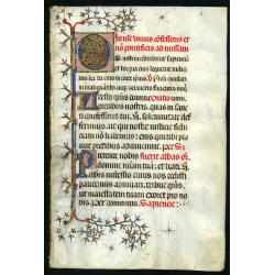
Leaf on vellum from a Missal.
A very fine Missal leaf, written in Latin. RECTO: A wonderful initial O decorated with pen work in red, purple and blue. The initial is 6x6cm. VERSO: one initial "I&...
Place & Date: France, c. 1410

World Flight Routes (all in Japanese).
A large very decorative Japanese world map published as sugoroku (a Japanese game which might be compared to backgammon) published as a supplement to the 1930 New Year’...
Place & Date: Osaka, 1930
![The Coast of New Found Land From Salmon Cove to Cape Bonavista. . . [together with] The Coast of New Found Land from Cape-Raze to Cape St-Francis.](/uploads/cache/40658-250x250.jpg)
The Coast of New Found Land From Salmon Cove to Cape Bonavista. . . [together with] The Coast of New Found Land from Cape-Raze to Cape St-Francis.
Two charts showing the coast of New Found Land from Salmon Cove to Cape Bonavista and from Cape-Raze to Cape St-Francis. With inset chart of Trinity HarborGrierson publis...
Place & Date: Dublin, 1767

Colossus Monarchic. Statua Danielis
Fantastic double page allegorical map of a colossus figure representing the great world empires as Daniel interpreted in Nebuchadnezzar's dream. The warrior stands stolid...
Place & Date: Augsbourg, 1730

Archipelague du Mexique ou sont les Isles de Cuba..
Scarce map of Caribbean. A visually stunning map with a large title cartouche. This large one-sheet map was produced by the Venetian cosmographer Vincenzo Coronelli when ...
Place & Date: Paris, 1688
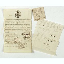
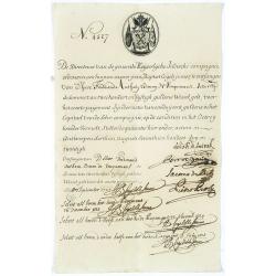
Very rare share in the Ostend Company.
Upper left hand corner share number 2305 in manuscript. In top emblem of the Ostend Company in copper engraving. Text: De Directeurs van de generale Keijserlijche- Indisc...
Place & Date: Antwerp / Ostend, 1723

L'Arabia delineata sulle ultime osservazioni.
First edition on laid paper. Cassini’s splendid early map of Arabia.
Place & Date: Rome, 1797

Asiae Minoris nova descriptio. Geographische Beschryvinge aller Landen... ende sendbrieuen der Apostele...
Extremely rare map from a Dutch bible, published by Dancker Danckerts. This map was included in a Dutch bible including several maps signed by C.Danckerts and one dated 1...
Place & Date: Amsterdam, 1643

Isole dell'Indie. . .
A beautiful and flamboyantly engraved large-scale map of the East Indies, including the Malay Peninsula, Cambodia, the Philippines and all of Indonesia and the Spice Isla...
Place & Date: Venice, 1696
![[Taprobana - Sri Lanka]](/uploads/cache/33847-250x250.jpg)
[Taprobana - Sri Lanka]
Wood block printed map and one of earliest printed representation of Ceylon prepared Martin Waldseemüller.Based on the slightly larger map from 1513 published in "P...
Place & Date: Vienna, Trechsel, G., 1525 -1541

Beschrijving Gezicht van den Ykant af bezyden den Schreiers hoex Toren langs de Keulsche en Geldersche Kaei naer de Nieuwe Markt
This large engraving (560x920mm.) comes from a are series of 25 beautiful large views of Amsterdam and gives a colorful picture of the life and business of the city at th...
Place & Date: Amsterdam, ca. 1720