Browse Listings

Carte d'Europe . . .
Rare. Uncommon and decorative wall map of Europe, prepared by Clouet. With superb decoration including a wonderful rococo border with vignettes describing historical scen...
Place & Date: Paris, 1785-1788

A Perspective View of the Admiralty Office, Dock-Yard, Storehouses &c. at Amsterdam.
Decorative engraving giving good detail of the intense activity in the Amsterdam dockyards.Engraved for BANKES's New System of Geography
Place & Date: Amsterdam, 1780

Carte Réduite De La Partie Septentrionale De L'' Isle De Terre Neuve..
A well engraved and highly detailed chart, corrected to 1767. Elaborate hand-colored cartouche, rhumb lines.Shows northern part of Newfoundland and southern coast of Labr...
Place & Date: Paris, 1767

Africa juxta navigationes et observat recentissimas. . .
Miniature map of Africa, a reduction of the Seutter folio map based on Homann''s cartography of 1715. Very detailed - much of it fictitious. The Nile is shown not only or...
Place & Date: Augsburg, J.M.Will, 1778
![[Title page] Perspective die hooch-gheroemde conste..](/uploads/cache/25554-250x250.jpg)
[Title page] Perspective die hooch-gheroemde conste..
Title page from Perspective, Dat is, de hooch-gheroemde conste eens schijnende in oft door-siende ooghen-ghesichtespunt ... (&c.) by Hans, or Johannes Vredeman de Vri...
Place & Date: Leiden, 1604
![[Butterflies]](/uploads/cache/25587-250x250.jpg)
[Butterflies]
Plate CXXIV from Carl Gustav Jablonsky and J.F.W. Herbst: "Natursystem aller bekannten in- und ausländischen Insecten", engraved by Bodenehr. Carl Gustav Jablo...
Place & Date: Berlin, J. Pauli, 1785-1806

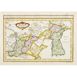
Walachia Servia, Bulgaria, Romania.
The cartographer of this map was Gerard Mercator. This attractive map of the Eastern Balkans is centered on Bulgaria and includes the Bosphorus and Constantinople. The Da...
Place & Date: Oxford, 1680

Carte des parties Nord et est de l'Asie..
Five maps on one sheet show the Northern Russian territories in Europe and Asia, including the western coastline from Siberia, Japan, and Korea with the island of "Q...
Place & Date: Paris, 1779

Carte d'une Partie des Cotes de la Floride et de la Louisiane, Contenant le Cours du Mississipi...
A well engraved and highly detailed chart of part of the Gulf Coast, dated 1778 that was issued in Neptune americo-septentrionale. The chart covers the area between St. J...
Place & Date: Paris, 1778-1780

Beschrijvinge vande de zee Cuften va Vlanderen en Picardien. . .
DUTCH TEXT EDITION. A detailed chart of the coast of Flanders and Normandy decorated by a large colorful baroque title cartouche, and the coat of arms of Flanders with a ...
Place & Date: Leiden, Plantijn, 1585

De zee cuften tufschen Dovere en Orfords nesse, daer de Teemse de Vermaerde Rivire van Lonen gelegens is. . .
A detailed chart of the English Channel coastland. Decorated by a colorful title cartouche and scale cartouche, one compass rose, several vessels and sea monsters. A very...
Place & Date: Leiden, Plantijn, 1585

Belchrijuinghe vande zee custen van Engelandt. . .
A rare Dutch text edition of this detailed early chart of the northern coast of England. West to the top. The mileage cartouche has no Latin captures. Decorated by a colo...
Place & Date: Leiden, Plantijn, 1585

Zee caerte vande Sondt tvermaerste van Danemarcke . . .
A detailed chart of the coast of Denmark and its islands, Copenhagen in the center of the chart. West to the top. It is decorated by a title, scale and descriptive cartou...
Place & Date: Leiden, Plantijn, 1585

Plan de la Ville et Port d'Antibes.
An attractive chart centered on the Mediterranean. With a scale and large compass-rose. Dated 1727, with the privilege of the King. From : Recueil des Plusieurs plans des...
Place & Date: Marseille, 1730

Paraguay, Chili, Terre Magellan ?
Map of Paraguay, Chili, and Argentina . By C. F. Delamarche, successor of Robert de Vaugondy, Geographer.
Place & Date: Paris, 1794 -1806

Reis-kaart van het Britsche gezantschap van Hang-choe-foe naar Quang-choe-foe of Kanton in China.
Uncommon map of eastern part of China, showing a journey of the English Embassy from Hangzhou (south of Shanghai) to Guangzhou (Canton). The maps is giving a wealth of in...
Place & Date: Netherlands, c.1800

Botanibay, Englischer Verweisungs Ort fur Verbrecher. / Laijene Franzosicher Verweisungs Ort fur Verbrecher.
Copper engraving with four scenes and one portrait of Frederick III of Saxony on one sheet. In the upper part fanciful views of Botany Bay with English and French settlem...
Place & Date: Zittau, 1798-1800

Erfolgte Kapitulation zwischen dem General Bonaparte und den Gross Leister von Malta. Vor der Hauptstadt Walette zu Maltha, am 10 Juni 1798.
Copper engraving with three scenes and one portrait on one sheet. In upper a view of Bonaparte arriving at Valletta. Published in "Allgemeine Welt-Chronik oder neue ...
Place & Date: Zittau, 1798-1800
![Morokoshi Meisho Zue [Illustrated Description of Famous Sites of China].](/uploads/cache/34118-250x250.jpg)
Morokoshi Meisho Zue [Illustrated Description of Famous Sites of China].
Published in Osaka, Kawachiya Genhichiro, et al. [8 book sellers], slightly later issue but apparently in Edo period, using all the same woodblocks of original first edit...
Place & Date: Osaka, Edo, slightly later than Bunka 3, year of the tiger - 1806
Carte du Katay ou Empire de Kin. . .
The map is of interest for the use of Mer de Corée, for the sea between Korea and Japan .Fine map of Korea and China's Yellow Sea. Complete title in top: Carte du Katay ...
Place & Date: Paris, 1750

Description geographique, historique, chronologique, politique, et physique de l'empire de la Chine et de la Tartarie chinoise . . . du Thibet, & de la Coree. . .
Without the separately published atlas. Lacking 2 plates in vol.2 (Obseques at p.149 and Gin seng at p.180), one plate torn without a loss (vol.1, p.230), d4 vol.1 with a...
Place & Date: The Hague, H. Scheurleer, 1736

Royaume de Bohéme, Marquisat de Moravie, et Silésie Autrichenne.
Small detailed map of today Czech Republic. From Atlas Portatif Universel, by Robert de Vaugondy.Unrecorded state with erased date. Page 32 outside border top right. Mary...
Place & Date: Paris, later than 1749
![Sexta Etas Mundi. Foliu CXXXV [Text page with S. Hieronymus, the patron of theological learning].](/uploads/cache/25763-250x250.jpg)
Sexta Etas Mundi. Foliu CXXXV [Text page with S. Hieronymus, the patron of theological learning].
Text page with woodcuts of the following saints: S. Hieronymus, the patron of theological learning (100x80mm.)VERSO is printed with text and images of Popes and Kings.Pag...
Place & Date: Nuremberg, 12 July 1493

Le Grand Mongol. . .
Rare full portrait of the Mongol emperor of Indostan, published by map seller, François Jollain, the Elder (1641-1704), active in Paris, rue St. Jacques à la ville de C...
Place & Date: Paris, ca. 1686

De golf van Bengalen.
Rare chart of the Indian Ocean, with nice detail on Ceylon (Sri Lanka) with compass roses and a system of rhumb lines, soundings and anchorage's. Many place names. The pl...
Place & Date: Amsterdam, after 1669-1712
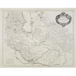
Carte de l'Empire de Perse. . .
Map of the Persian empire by the Venetian cartographer and publisher François (Père) Santini and first published in Santini's 'Atlas Universel dressée sur les meuilleu...
Place & Date: Venice, 1784
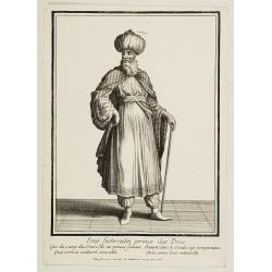
Emir Fechrredin prince des Drus.
Engraving published by Nicolas Bonnart (c.1637 - 1718), engraver in Augsburg since 1719. Before the nineteenth century portraits of rulers in the Islamic Middle East were...
Place & Date: Paris, ca. 1740

Isola di Madagascar o di S. Lorenzo Scoperta dà Portoghesi nell anno 1506. . .
Decorative and highly detailed map of Madagascar, including 2 decorative cartouches and other embellishments.The remarkable Vincenzo Coronelli (1650-1718), was a Francisc...
Place & Date: Venice, 1690

Pianta Geografia delle Isole di Malta, e Gozo della Sagra Religione Gerosolimitana di S. Giovanni delineata, ed incisa in quest anno 1761.
A rare map of Malta and Gozo printed by the priest Antonio Bova (1688 - 1775), who was active as engraver in Palermo ca. 1727-1773. He produced cartographic engravings, s...
Place & Date: Bova Ant., Palermo, 1761

Mappa Aestivarum Insularum alias Barmudas.
Blaeu based his work on John Speed's remarkably accurate map of 1626-1627. It shows the island divided into tribes and lots, and below the map itself appear the names of ...
Place & Date: Amsterdam, 1635

Nova et Accurata totius EUROPAE Descriptio Authore Frederico de Wit Amstelodami.
General map of Europe richly ornamented with small compass rose and Europa shown riding Zeus in the form of a bull, and several putti holding the title banner aloft.
Place & Date: Amsterdam, 1680

Alssleben.
The engraver and publisher of prints, Mrs. Anna Beek of the Hague, enlarged the print and mounted it on larger paper: she colored it in pastel colors, adding extensive cl...
Place & Date: The Hague, ca. 1700
![Carthage, etc. [Foliu XL ]](/uploads/cache/26122-250x250.jpg)
Carthage, etc. [Foliu XL ]
VERSO: Portraits of scholars, and an imaginary view on Carthage in Tunisia (12x17cm.) Page from the famous Liber chronicarum of Hartmann-Schedel 1493, the first and Latin...
Place & Date: Nuremberg 12 July 1493

La Tartaria Chinese.
With decorative title cartouche. Covering north eastern part of China, with good detail in Korea and a curious shape for Hokkaido (here called Jeso-Gasima ).Engraved by G...
Place & Date: Venice, 1784
![[Crimea]. Carte de la Cromée.](/uploads/cache/25719-250x250.jpg)
[Crimea]. Carte de la Cromée.
Mapmaker, Captain Jan Hendrik van Kinsbergen (1735-1819). Published by H. Friesman in 1787. This map first appeared in 1776 and was the first Russian map of the newly ann...
Place & Date: Amsterdam, H. Frieseman, 1787
![Vue de la Rivière d'Endeavour sur la Côte de la Nouvelle Hollande ou le Vaisseau fut mis à la bande. [Tome IV Pl. 1ère.]](/uploads/cache/26093-250x250.jpg)
Vue de la Rivière d'Endeavour sur la Côte de la Nouvelle Hollande ou le Vaisseau fut mis à la bande. [Tome IV Pl. 1ère.]
The first known landscape drawing of the east coast of Australia. A View of the Endeavour River, on the coast of New Holland, where the ship was laid on shore, in order t...
Place & Date: Paris, 1773
![[ Traditional tools from New Caledonia ].](/uploads/cache/26366-250x250.jpg)
[ Traditional tools from New Caledonia ].
Aquatint depicting a variety of traditional tools from New Caledonia engraved by Rossi. Plate N° 72. From Giulio Ferrario's work Le Costume Ancien et Moderne ou Histoi...
Place & Date: Milan, 1827
![[Perspective print after J. Vredeman de Vries. ]](/uploads/cache/26445-250x250.jpg)
[Perspective print after J. Vredeman de Vries. ]
Engraving depicting the use of the vanishing point. From Les cinq rangs de l'architecture, a savoir, Tuscane, dorique, ionique, corinthiaque et composée avec l'instructi...
Place & Date: The Hague, 1606

Canibales Insulae.
Rare, early Dutch nautical chart of the Caribbean from Puerto Rico southward.
Place & Date: Amsterdam, 1670

Carte de L\'Egypte de la Nubie de L\'Abissinie. . .
Prepared by G.de l'Isle. Uncommon issue by Hendrik de Leth. Very detailed map of northeastern Africa, the Red Sea and the Arabian peninsula shows the political divisions ...
Place & Date: Amsterdam, 1740