Browse Listings
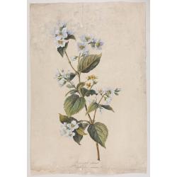
Seringat odorant. Philadelphus coronarius. L.
Bouquet of Seringats. A bouquet of flowers. Engraved by P.F. Le Grand after designs by the Dutch born Gerard van Spaendonck (1746-1822).Taken from the rare work "Fle...
Place & Date: Paris, c. 1800
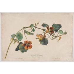
Grande Capucine Tropoeolum majus. L.
The true Nasturtium, stipple engraving by P.F. Le Grand after designs by the Dutch-born Gerard van Spaendonck (1746-1822).Taken from the rare work "Fleurs dessinées...
Place & Date: Paris, c.1800

Vue du sperbe Temple de St.Sophie .. a Constantinople.
A fanciful depiction of the Aya Sofya in Istanbul. In the eighteenth and nineteenth centuries there were many popular speciality establishments in Paris, Augsburg and Lon...
Place & Date: Paris, 1800

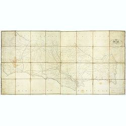
Carte des côtes du Golfe du Mexique compris entre la pointe sud de la presqu'Ile de la Floride et la pointe nord de la presqu'Ile d'Yucatan: Dresée d'après le observations et las plans des espagnols, ...
Detailed and important early chart of the Gulf Coast and Florida and dated 1800. First French edition of "the first printed [map] to show and name Galveston Bay&qu...
Place & Date: Paris, 1800

Reis-kaart van het Britsche gezantschap van Hang-choe-foe naar Quang-choe-foe of Kanton in China.
Uncommon map of eastern part of China, showing a journey of the English Embassy from Hangzhou (south of Shanghai) to Guangzhou (Canton). The maps is giving a wealth of in...
Place & Date: Netherlands, c.1800

Botanibay, Englischer Verweisungs Ort fur Verbrecher. / Laijene Franzosicher Verweisungs Ort fur Verbrecher.
Copper engraving with four scenes and one portrait of Frederick III of Saxony on one sheet. In the upper part fanciful views of Botany Bay with English and French settlem...
Place & Date: Zittau, 1798-1800

Erfolgte Kapitulation zwischen dem General Bonaparte und den Gross Leister von Malta. Vor der Hauptstadt Walette zu Maltha, am 10 Juni 1798.
Copper engraving with three scenes and one portrait on one sheet. In upper a view of Bonaparte arriving at Valletta. Published in "Allgemeine Welt-Chronik oder neue ...
Place & Date: Zittau, 1798-1800
![[ Manuscript map of the Ligurian coast from Pietra to Genova ].](/uploads/cache/26627-250x250.jpg)
[ Manuscript map of the Ligurian coast from Pietra to Genova ].
Very detailed French manuscript map of the Ligurian coast from Pietra and Finale, Savone to Genoa with the Maritime Alps in the background. The Liguria coast borders to n...
Place & Date: France, ca. 1790-1800
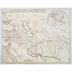
Partie Orientale de la Carte des Anciennes Monarchies. . .
This map depicts the eastern part of the Ancient World, Partie Occidentale de la Carte des Anciennes Monarchies including the Near East, Cyprus, Black Sea, Caspian Sea, I...
Place & Date: Paris, ca. 1800

Lion and Bull made of terracotta.
Very fine terracotta figure of a lion symbolizing the continent of Africa. The Bull symbolizing Europe.The items will be dispatched in 4 wooden crates from Belgium. Pleas...
Place & Date: Netherlandisch , 1780~1800
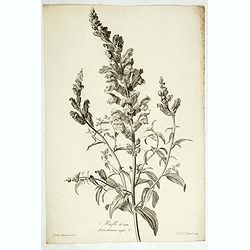
Mufle de veau. Antirrhinum majus L.
Bouquet of Common Snapdragons, engraving by P.F. Le Grand after designs by the Dutch born Gerard van Spaendonck (1746-1822).Taken from the rare work "Fleurs dessiné...
Place & Date: Paris, c.1800
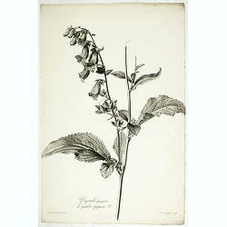
Digitale pourprée. Digitalis purpurea L.
The foxglove, engraving by P.F. Le Grand after designs by the Dutch born Gerard van Spaendonck (1746-1822).Taken from the rare work "Fleurs dessinées d'après natur...
Place & Date: Paris, c.1800
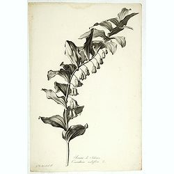
Sceau de Salomon. Convallaria multiflora L.
King Solomon's Seal or David's Harp, engraving by P.F. Le Grand after designs by the Dutch born Gerard van Spaendonck (1746-1822).Taken from the rare work "Fleurs de...
Place & Date: Paris, c.1800
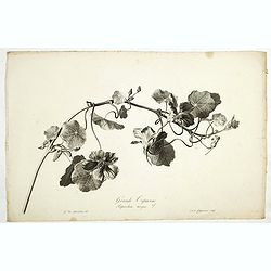
Grande Capucine. Tropaeolum majus. L.
Indian cress or monks cress, engraving by P.F. Le Grand after designs by the Dutch born Gerard van Spaendonck (1746-1822).Taken from the rare work "Fleurs dessinées...
Place & Date: Paris, c.1800

La China e Giapone.
Uncommon map of China, Korea, Japan and Taiwan (I.Formosa), only one town labeled, Tayoan. Very strange shape for Japan.The map is of interest for the use of Mar di Corea...
Place & Date: Italy, ca. 1800

Deutschlands Postkarte begraenzt von Oesterreich, Preussen, Frankreich, Holland, Italien und der Schweiz. . .
Detailed and important post road map prepared by Ignaz Heymann. The map shows, the Low Countries, Germany, Poland, Austria, Hungary, etc.Borders in original out-line colo...
Place & Date: Triest, 1800

Recueil de cartes géographiques pour la description de l'Indostan . . .
First French edition, the maps revised by Jean Nicholas Buache. The English original edition was published in London in 1783 by Brown under the title "Memoir of a ...
Place & Date: Paris, Poignée, an VIII = 1800

Early 19th century magnetic dry card compass with wooden bowl,
Brass dry rose marine compass, in its mahogany case. The mariner's compass, which enabled mariners to know the direction in which they were sailing, has always been one o...
Place & Date: ca. 1800

Shinkan Nagasaki no Dzu.
The oldest of these so-called Nagasaki pictures (Nagasaki-zu) were two panoramic prints by the artist Chikujuken that served as guides to the city of Nagasaki for visitor...
Place & Date: Nagasaki, 1801

Bowles's new four-sheet map of England and Wales. . .
Bowles's new four-sheet map of England and Wales: Comprehending all the Cities, Boroughs, Market and Sea-Port Towns, Villages, Lakes, Rivers, Forests, Ruins, Canals, and ...
Place & Date: London, 1801

Kaart Van Nieuw Zeeland in de Jaaren 1769 en 1770 bezogt door den Luitenant J. Cook met het Schip De Endeavour.
A uncommon issue of this key map of New Zealand from the Dutch edition of Cook's map of New Zealand, published in 'Reize rondom de Waereld door James Cook', a Dutch editi...
Place & Date: Leyden, Amsterdam & The Hague: Honcoop, Allart & van Cleef, 1795-1801
![Schat-Kamer ofte konst der stuurlieden, inhoudende Een duidelyke onderwyzinge in de navigatie. . . [bound with] Geographische Tadfel vande Graaden.. Voornaamste Zee-haavens. . .](/uploads/cache/33114-250x250.jpg)
Schat-Kamer ofte konst der stuurlieden, inhoudende Een duidelyke onderwyzinge in de navigatie. . . [bound with] Geographische Tadfel vande Graaden.. Voornaamste Zee-haavens. . .
Rare and important manual originally prepared by Klaas de Vries and improved by Evert Floryn and S.Hollander of the "Schat-Kamer ofte konst der stuurlieden" (Tr...
Place & Date: Amsterdam, Wed. Gerard Hulst van Keulen, 1802

Guyana, Surinam, Amapa.
Very rare Ottoman printed map of Guyana, Suriname and Amapa. With Trinidad, an inset map of the mouth of the Rivers Essequibo, Courantyne, Suriname with Paramaribo.From C...
Place & Date: Üsküdar (Istanbul), 1803
![Bunken Edo oezu. [Tokyo]](/uploads/cache/12826-250x250.jpg)
Bunken Edo oezu. [Tokyo]
Based on map by Ochikochi Doin. Oriented with north to the right. An extraordinary wood block-printed town-plan now-a-day Tokyo, and a fine example of Edo cartography. Th...
Place & Date: Edo, ca. 1803

Teatro della guerra nelle Flandre Austriache e Francesi. . .
Rare folio-sized map of Belgium by Antonio Zatta e Figli, from a never-finished atlas by the ‘Società Calcografia’, a partnership of the two main Venetian publishers...
Place & Date: Venise, 1803

Map of China.
Showing China, Taiwan and Korea, divided into provinces with the main cities marked. The map is of interest for the use of Sea of Corea, the sea between Korea and Japan, ...
Place & Date: London, 1804

A Map of the Environs of Constantinople Drawn from a great number of accurate astronomical & geographical manuscripts and printed documents, by A. Arrowsmith 1801 and 1804.
Arrowsmith’s large and detailed map of the Ottoman Empire and the Black Sea, with Cyprus, Crete and the Greek Islands in the Mediterranean Sea, Albania, Bosnia and Herz...
Place & Date: London, No.10 Soho Square, 4th September 1804
![[Butterflies]](/uploads/cache/25587-250x250.jpg)
[Butterflies]
Plate CXXIV from Carl Gustav Jablonsky and J.F.W. Herbst: "Natursystem aller bekannten in- und ausländischen Insecten", engraved by Bodenehr. Carl Gustav Jablo...
Place & Date: Berlin, J. Pauli, 1785-1806

Paraguay, Chili, Terre Magellan ?
Map of Paraguay, Chili, and Argentina . By C. F. Delamarche, successor of Robert de Vaugondy, Geographer.
Place & Date: Paris, 1794 -1806
![Morokoshi Meisho Zue [Illustrated Description of Famous Sites of China].](/uploads/cache/34118-250x250.jpg)
Morokoshi Meisho Zue [Illustrated Description of Famous Sites of China].
Published in Osaka, Kawachiya Genhichiro, et al. [8 book sellers], slightly later issue but apparently in Edo period, using all the same woodblocks of original first edit...
Place & Date: Osaka, Edo, slightly later than Bunka 3, year of the tiger - 1806
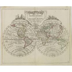
Mappe-Monde ou Description du Glôbe Terrestre Assujettie aux Observs Astronoms.
Double hemisphere map with a curious shape for Australia, from Atlas moderne portatif composé de vingt-huit cartes sur toutes les parties du globe terrestre .. A l'usage...
Place & Date: Paris, Prudhomme, Levrault, Debray, 1806

Siberie ou Russie Asiatique, Tartarie Chinoise, Pays des Eluts et Isles du Japon.
Map of the Kamchatka peninsula, Russian Far East., Korea, Japan, with Hokkaido labeled "Terre del Jeso".By C. F. Delamarche, successor of Robert de Vaugondy, Ge...
Place & Date: Paris, 1794 - 1806

Asia.
Uncommon map of Asia. Engraved by Marco di Pietro.The map is of interest for the use of G. di Corea, for the sea between Korea and Japan.Published by Carlo Antonio Barbie...
Place & Date: Milan, 1807

Carte de L'Archipel de La Recherche a la partie Occidentale de la Terre de Nuyts. . .
A large and detailed chart of the southern West Australian coast centered on the region of Esperance and the surrounding islands.Terre de Nuyts is the name that was forme...
Place & Date: Paris 1807

Carte Réduite Du Golphe Du Mexique Et Des Isles De L' Amérique..
A well engraved and highly detailed chart prepared by Bellin of the Gulf of Mexico and the Caribbean. In addition to a magnificent title cartouche and a color key to the ...
Place & Date: Paris dated year 17, or 1808
Carta militar das principaes estradas de Portugal.
Rare road map of Portugal in a scale of ca 1:470000. At the bottom right and left legends in Portuguese and French. Engraved by Romão Eloy de Almeida, who was a Portugue...
Place & Date: Lisbone, 1808
![Boats of the Friendly Islands. [together with] A Sailing Canoe of Otaheite.](/uploads/cache/30041-250x250.jpg)
Boats of the Friendly Islands. [together with] A Sailing Canoe of Otaheite.
Early view of Queen charlotte's sound, taken from "Views in the South Seas" being a very important and early views depicting scenes encountered while employed a...
Place & Date: London, Boydell and Co., 1808

View of the harbour of Taloo, in the island of Eimeo.
John Webber View of the Harbour of Taloo on Moorea (Society Islands), from "Views in the South Seas" being a very important and early views depicting scenes enc...
Place & Date: London, Boydell and Co., 1808
![A Toopapaoo of a Chief, with a priest making his offering to the Morai, in Huoheine. [Huaheine - the Society Islands]](/uploads/cache/30045-250x250.jpg)
A Toopapaoo of a Chief, with a priest making his offering to the Morai, in Huoheine. [Huaheine - the Society Islands]
A view of a chief's raised burial chamber in Huaheine, Society Islands, taken from "Views in the South Seas" being a very important and early view depicting sce...
Place & Date: London, Boydell and Co., 1808

The narta, or Sledge for burdens in Kamtschatka.
The narta, or Sledge for burdens in Kamtschatka, taken from "Views in the South Seas" being a very important and early views depicting scenes encountered while ...
Place & Date: London, Boydell and Co., 1808