Browse Listings in Maritime
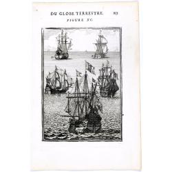
DU GLOBE TERRESTRE - Figure XC. 253
Finely engraved plate of various types of sailing ships.From the French text edition of Description d'Univers.. (5 volumes), 1683. By Allain Manneson Mallet (1630-1706), ...
Place & Date: Paris, 1683
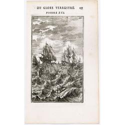
(Ships on full sea)
A fine engraving of different sailing vessels at full sea.From the French text edition of Description d'Univers.. (5 volumes), 1683. By Allain Manneson Mallet (1630-1706)...
Place & Date: Paris, 1683

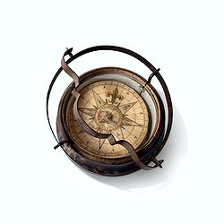
Early 19th century magnetic dry card compass with wooden bowl,
Brass dry rose marine compass, in its mahogany case. The mariner's compass, which enabled mariners to know the direction in which they were sailing, has always been one o...
Place & Date: ca. 1800

Tabula Anemographica seu Pyxis Nautica.
Impressive compass rose with a fleur de lis at the center and 32 wind directions flowing from it identified in six languages, Greek, Latin, French, Dutch, Italian, and Sp...
Place & Date: Amsterdam, 1650
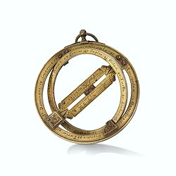
Very fine brass astronomical equinoctial ring with two brass circles.
Very fine brass astronomical equinoctial ring with two brass circles with engraved foliage decoration, signed "Jean-Baptiste-Nicolas Delure A Paris", on the han...
Place & Date: Paris, undated, ca. 1690
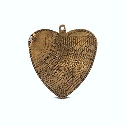
A cordiform - heart-shaped - horary quadrant marked with Gunter scales.
A small and charming but very fine heart-shaped horary quadrant marked with Gunter scales. The scales are very finely engraved on both sides.The quadrant was a very pract...
Place & Date: ca. 1720-1760
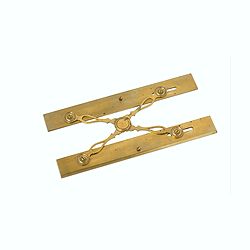
Marine parallel rulers in brass.
Very fine marine parallel rulers in brass. The parallel ruler is the oldest and most traditional way to measure and trace routes and bearings. The principle is simple: t...
Place & Date: Paris, ca. 1880
Inverted nautical Compass, called "mouchard" (~ "spy")
Inverted maritime compass called "mouchard" (spy) in wood and brass, signed "A Van Vastenhoud In Amsterdam". This type of compass was found in the cap...
Place & Date: Amsterdam, ca. 1780
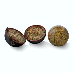
Globe, Miniature, Terrestrial Pocket Globe in Celestial Case
A pocket globe, of typical form, the terrestrial globe with engraved hand-colored gores, having holes at the poles but no axis pins (as issued). The globe is contained wi...
Place & Date: London, ca. 1780

Hydrograhica descriptio
This very rare chart is important as the first printed sea chart of the Mediterranean coast of Spain, Gibraltar, also depicting the northern coast of Marocco.Willem Bar...
Place & Date: Amsterdam, W.Blaeu, 1612