
Cochin (today: Ernakulam)
Small but charming 18th water color on paper depicting Cochin (today : Ernakulam) was from 1500, when the first Portuguese fleet called on its port, a firm ally of the Po...
Place & Date: India? c.1750

Nieuwe kaart van 't Koninckryk Bengale. . .
Rare map Bangladesh with the Ganges delta, including Calcutta. Giving great detail with trade routes, European trade settlements, etc. Prepared by Joh. Van Leenen who was...
Place & Date: Amsterdam, 1726

Carte nouvelle des Terres de Cucan..
Prepared by H.Reland (1676-1718) a professor active in Utrecht and specialized in Asian languages, geography and religions. His first map was a map of Japan copied after ...
Place & Date: The Hague, 1728

De golf van Bengalen.
Rare chart of the Indian Ocean, with nice detail on Ceylon (Sri Lanka) with compass roses and a system of rhumb lines, soundings and anchorage's. Many place names. The pl...
Place & Date: Amsterdam, after 1669-1712
Penisola dell India di là dal Gange et Isole intorno ad essa adiacenti..
Giacomo Rossi's fine late 17th century map of India with Ceylon and Maldives. Issued in Il Mercurio geografico In lower right hand corner a large title cartouche with ded...
Place & Date: Rome, 1683-1688

Recueil de cartes géographiques pour la description de l'Indostan . . .
First French edition, the maps revised by Jean Nicholas Buache. The English original edition was published in London in 1783 by Brown under the title "Memoir of a ...
Place & Date: Paris, Poignée, an VIII = 1800
![.[India]](/uploads/cache/33861-250x250.jpg)
.[India]
Wood block printed map and one of earliest printed representation of India prepared by Martin Waldseemüller. Based on the slightly larger map from 1513 published in &quo...
Place & Date: Vienna, Trechsel, G., 1525 -1541
![.[Bangladesh, Burma, India, Thailand]](/uploads/cache/33867-250x250.jpg)
.[Bangladesh, Burma, India, Thailand]
Wood block printed map and one of earliest printed representation of Bangladesh, Burma, India, Thailand prepared Martin Waldseemüller. Based on the slightly larger map f...
Place & Date: Vienna, Trechsel, G., 1525 -1541

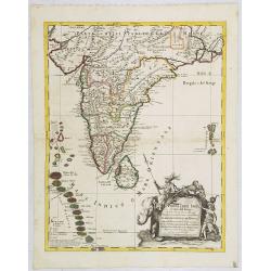
Carte du Golfe de Bengale, mer des Indes et rivieres du Gange . . .
Detailed scare map of the Southern part of India with Ceylon. Good detail along the coasts of Malabar, Coromandel, the Maldives islands and the Kingdoms of Visipour, Golc...
Place & Date: Leide, 1719
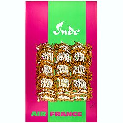
Inde.
Decorative poster advertising flights to India made by Georges Mathieu. The poster is one of a series of 15 composed of posters of Greece, Israel, Germany, Great Britain,...
Place & Date: Paris, 1967