Browse Listings
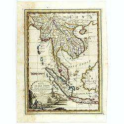
La Penisola delle Indie di la' dal Gange con parte delle Isole della Sonda delineate sulle ultima osservazioni.
First edition on laid paper. Cassini’s splendid early map of Indochina, from Bangladesh in the west to central Borneo in the east, and southern China in the north, to B...
Place & Date: Rome, 1797
![[Complete set of maps of Japan] Imperium Japonicum Per Regiones Digestum Sex et Sexaginta Atque Ipsorum Japonensium Mappis Descriptum Ab Hadriano Relando.](/uploads/cache/41590-250x250.jpg)
[Complete set of maps of Japan] Imperium Japonicum Per Regiones Digestum Sex et Sexaginta Atque Ipsorum Japonensium Mappis Descriptum Ab Hadriano Relando.
Complete set of 11 maps Reland's map of Japan, the first map to use Sino-Japanese characters on a European printed map and represents a radical departure from prior Europ...
Place & Date: Amsterdam, 1751

Ducatus Prussiae tam Polono Regiae. . .
This is a rare issue of Frederick de Wit's attractive map of the northern part of Poland, Prussia and the Baltic regions.Very decorative title cartouche, including three ...
Place & Date: Amsterdam, 1698

Nieuwe en zeer accuraate Zee-Caart van de Hollandse Wal strekkende van de Maas tot Texel opgenomen door Jan Rokusz Douw, , ,
A very fine and rare chart of the coast of Holland, Prepared by Jan Rokusz, Douw and Agge Roskam Kool.Embellished with a very decorative cartouche with a dedicational tex...
Place & Date: Amsterdam, 1750

Archipelague du Mexique ou sont les Isles de Cuba..
Scarce map of Caribbean. A visually stunning map with a large title cartouche. This large one-sheet map was produced by the Venetian cosmographer Vincenzo Coronelli when ...
Place & Date: Paris, 1688

Urbium Londini et West-Monasterii nec non Surburbii Southwark Accurata Ichnographia ,., Neuester Grundris der Staedte London und West-Munster, Samt der Vorstadt Southwark ,.,
Detailed plan of London, extending from Grosvenor Square in the west to Mile End to the east, To the right inset views of St, James's Square, and Custom House, elevations...
Place & Date: Nuremberg, 1736
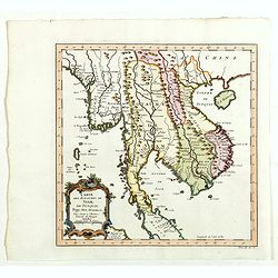
Carte des Royaumes de Siam, du Tunquin, Pegu, Ava, Aracan . . .
Map of Siam, du Tunquin, Pegu, Ava, Aracan. Across the top is an extensive list of 22 important sites and locations keyed to the plan with tiny letters and numbers.Jacque...
Place & Date: Paris, 1750

India Tercera Nuova Tavola.
The 1598 edition of this early map of South East Asia. Just to the west and south of Malacca one will notice ‘Camatra’ (Sumatra) and Java. China with Canton in the up...
Place & Date: Venice, 1598
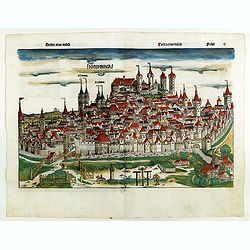
Nuremberga. Folio C.
Double page panoramic view of Nuremberg. Lettered above the view: "NVREMBERGA"; and with the names of the city's two most famous churches, S. Lorenz and S. Seba...
Place & Date: Nuremberg, 12 July 1493
Selling price: $1500
Sold in 2023

(EUROPE).
A woodcut colored map of northern and central Europe. The first modern map of the area. Second printed map of the North, after the woodcut map published in the 'Ulm' Ptol...
Place & Date: Nuremberg, 1493