Browse Listings

A plan of the City and Environs of Philadelphia. . .
The Lotter edition of Scull & Heap's seminal Philadelphia map, which map was first issued in 1752.Holmes' grid plan for the city is shown, situated between the rivers...
Place & Date: Augsburg, 1777

Palatinatus Rheni Nova et Accurata Descriptio.
Early state (1630) of Visscher's "carte à figures"- map of the German Rhine River Valley. Inset views of Frankfurt am Main, Mainz, Speyer, Worms and Heidelberg...
Place & Date: Amsterdam, 1630

Kamchatka according to A.Erman . . .
FIRST EDITION Map of the Kamchatka Peninsula, Siberia, from Gazetteer of the World. Drawn by Augustus Petermann, engraved by G. H. Swanston.
Place & Date: London / Edinburgh, 1850

Paraquariae Provinciae Soc. Iesu cum Adjacentibus Novissima...
Between the years of 1609 and 1780, the Jesuits (the Roman Catholic Society of Jesus) established in South America, an autonomous Christian state, on the lands of present...
Place & Date: Augsburg, 1740

Province de Pologne contenant 22 Col. une M.on Prof 5 Pen. 2 Nov. 6 Rés. 30 Maisons 1050 Jésuites.
Rare map of Poland from "Atlas Universel indiquant les établissemens des Jésuites: avec la manière dont ils divisent la terre, suivi desévénemens remarquables d...
Place & Date: Paris, Ambroise Dupont , 1826

Tabula Sexta Asia (Arabian Peninsula)
This is a very desirable early Ptolemaic woodblock map of the Arabian Peninsula, here called Arabia Felix. The map is presented on a trapezoidal projection with par...
Place & Date: Vienna, 1525 -1541

Tabula nova Poloniae et Silesiae.
Second state, dated 1630 underneath the title. A finely engraved carte á figures with cartouche representing in the four corners of the map : Kings ( on the left side Si...
Place & Date: Amsterdam, 1630
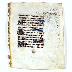
Leaf on vellum from a manuscript Book of Hours.
14 Lines of text in Latin and three 1-line initials in blue on colored grounds.RECTO: 14 Lines of text in Latin and three 1-line initials in blue on colored grounds with ...
Place & Date: France, ca.1470
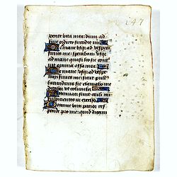
Leaf on vellum from a manuscript Book of Hours.
14 Lines of text in Latin and three 1-line initials in blue on colored grounds.RECTO: 14 Lines of text in Latin and four 1-line initials in blue on colored grounds with l...
Place & Date: France, ca.1470

Insularum Moluccarum Nova description.
Exquisite map of the famous Spice Islands based on the islands described by Jan Huyghen van Linschoten. This map was the first large-scale map of the region and depicts t...
Place & Date: Amsterdam, 1730