Browse Listings in Europe

Tabula Secunda Europe (Spain & Portugal)
Wood block printed large-format Ptolemaic map of the Iberian Peninsula from the 1513 edition of Waldseemüller's Geographia.This Ptolemaic map comes from the first so cal...
Place & Date: Strasburg, 1513
![[Europe, Eastern, Sarmatia, Ukraine]](/uploads/cache/33854-250x250.jpg)
[Europe, Eastern, Sarmatia, Ukraine]
Wood block printed map and one of earliest printed representation of Europe, Eastern, Sarmatia, Ukraine prepared L. Fries after Martin Waldseemüller.Based on the slightl...
Place & Date: Vienna, Trechsel, G., 1525 -1541
![.[Georgia (Republic), Sarmatia, Ukraine]](/uploads/cache/33870-250x250.jpg)
.[Georgia (Republic), Sarmatia, Ukraine]
Wood block printed map and one of earliest printed representation of Georgia (Republic), Sarmatia, Ukraine prepared by Martin Waldseemüller. Based on the slightly larger...
Place & Date: Vienna, Trechsel, G., 1525 -1541
![.[Italy]](/uploads/cache/33856-250x250.jpg)
.[Italy]
Wood block printed map and one of earliest printed representation of Italy prepared by Martin Waldseemüller. Based on the slightly larger map from 1513 published in &q...
Place & Date: Vienna, Trechsel, G., 1525 -1541
![.[Balkan region with Austria, Croatia, Slovenia, Switzerland, etc]](/uploads/cache/33858-250x250.jpg)
.[Balkan region with Austria, Croatia, Slovenia, Switzerland, etc]
Wood block printed map and one of earliest printed representation of Balkan with Austria, Croatia, Slovenia, Switzerland, etc prepared Martin Waldseemüller. Based on the...
Place & Date: Vienna, 1525 -1541
![[Albania, Bulgaria, Europe, Eastern, Greece, Hungary, Macedonia, Romania]](/uploads/cache/33868-250x250.jpg)
[Albania, Bulgaria, Europe, Eastern, Greece, Hungary, Macedonia, Romania]
Wood block printed map and one of earliest printed representation of Albania, Bulgaria, Europe, Eastern, Greece, Hungary, Macedonia, Romania prepared Martin Waldseemülle...
Place & Date: Vienna, Trechsel, G., 1525 -1541
![.[Germany and Poland]](/uploads/cache/33862-250x250.jpg)
.[Germany and Poland]
Wood block printed map and one of earliest printed representation of Germany, Poland, The Low Countries, Austria and Switzerland prepared by Martin Waldseemüller. Based ...
Place & Date: Vienna, Trechsel, G., 1525 -1541
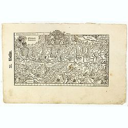
XI. Wallis.
Very early wood cut printed regional map of Switzerland with Wallis region.Originally engraved in 1548. The map was prepared by Johannes Stumpf (1500-1576). Included in &...
Place & Date: Zurich, Christoffel Froschover, 1548,1552-1566

XII. Laurater Basler gelegenheit.
Very early wood cut printed regional map of Switzerland with Basel region.Originally engraved in 1548. The map was prepared by Johannes Stumpf (1500-1576). Included in &q...
Place & Date: Zurich, Christoffel Froschover, 1548,1552-1566

IX. Die Lepontier.
Very early wood cut printed regional map of Switzerland.Originally engraved in 1548. The map was prepared by Johannes Stumpf (1500-1576). Included in "Landtaflen. Hi...
Place & Date: Zurich, Christoffel Froschover, 1548,1552-1566