Browse Listings in Europe > British Isles

39e Vüe d'Optique Representant L'Hotel du Lord Maire de Londre.
So-called optical print illustrating a perspective view of Somerset House on the Strand in London.In the eighteenth and nineteenth centuries there were many popular speci...
Place & Date: Paris, 1760

5e Vue d'Optique Representant La Vue interieure de la Cathedralle de St. Paul de Londres.
So-called optical print illustrating a perspective view of the interior of the Saint Paul cathedral in London. Engraved by la Marcade.In the eighteenth and nineteenth cen...
Place & Date: Paris, 1760

6e Vüe d'Optique Représentant Le Chœur de la Cathedrale de St. Paul de Londres.
So-called optical print illustrating a perspective view of the interior of the Saint Paul Cathedral in London.In the eighteenth and nineteenth centuries there were many p...
Place & Date: Paris, 1760
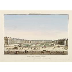
Vüe de la Place de Grosvenor a Londres.
So-called optical print illustrating a perspective view of Grosvenor Square, Mayfair, London. The centrepiece of the 100 acre Grosvenor Estate, it was built between 1725-...
Place & Date: Paris, 1760

Bowles's new four-sheet map of England and Wales. . .
Bowles's new four-sheet map of England and Wales: Comprehending all the Cities, Boroughs, Market and Sea-Port Towns, Villages, Lakes, Rivers, Forests, Ruins, Canals, and ...
Place & Date: London, 1801

Langley's New Travelling and Commercial Map . . .
A highly desirable, detailed and uncommon map of England and Wales, published by Langley and Belch. The map is flanked by a pair of large and detailed explanation tables,...
Place & Date: London, 1817

London in Miniature With The Surrounding Villages. An Entire New Plan In which the Improvements both present and intended are actually reduced, by permission, from the surveys of the Several Proprietors. . .
Hand-coloured engraved map, dissected and mounted on linen, orange publishers label on one side, extending west to east from Kensington to East India and Greenwich Dock a...
Place & Date: London, 1821

Wallis's Guide for Strangers Through London.
Engraved plan with original hand-coloring, with title and alphabetical list of the principal streets below. Published by Edward Wellis 42 Skinner Street.With "An alp...
Place & Date: London, E.Wallis, ca. 1840

AFFAIRES D'ORIENT Départ des Grenadiers de la Garde Anglaise, à bord du Steamer transatlantique l'Orenoco. . .
Beautiful lithography of the British steamboat "l'Orenoco" departure from Southampton in May 1854, with soldiers leaving for the Crimean War. After a design Lou...
Place & Date: Paris, Lemercier, c.1860
![[West Central London from Booth's Poverty Map of London]](/uploads/cache/40267-250x250.jpg)
[West Central London from Booth's Poverty Map of London]
A map of West Central London, one section (of twenty) of an extended version of the incredibly influential Poverty Map, originally published in Charles Booth's 'Life and ...
Place & Date: London, 1900