Browse Listings
![[The creation of the world - First day]](/uploads/cache/24509-250x250.jpg)
[The creation of the world - First day]
Attractive page from the Nuremberg Chronicle, showing the creation of the world: the First Day, showing the celestial choir (God\'s creation of the angels) surrounding th...
Place & Date: Nuremberg, 12 July 1493
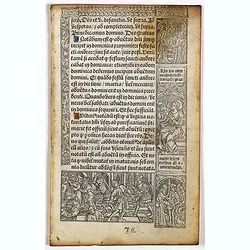
![[Text page with Kings, Queens, Saints and Popes. Sexta Etas Mundi. Folium. CXI].](/uploads/cache/46888-250x250.jpg)
[Text page with Kings, Queens, Saints and Popes. Sexta Etas Mundi. Folium. CXI].
Recto text page with woodcuts of Kings. Verso text page with woodcuts of Saints and Popes. Page from the richest illustrated Incunable, the famous: Nuremberg Chronicle, p...
Place & Date: Nuremberg, 12 July 1493
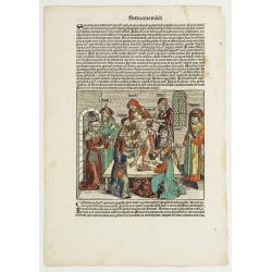
Sexta Etas Mudi. / Simon Beatus .. / Folio CCLIIII.
A very fine presentation of the circumcision of Simon (192 x 223 mm.). RECTO: a falling star, a portrait of a King and an officer wearing armour. Page from the richest il...
Place & Date: Nuremberg, 12 July 1493
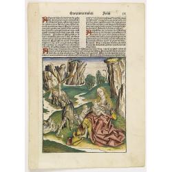
Prima Etas Mundi. IX (with Eve nursing Kain and Abel)
A very fine presentation of Eve nursing Kain and Abel. Adam is working (255x220 cm). VERSO a genealogy of Adam.Page from the richest illustrated Incunabel, the famous: Li...
Place & Date: Nuremberg, 12 July 1493

(EUROPE).
The map of Europe has been identified as the work of Hieronimus Münzer (1437-1508), a Nuremberg physician who supplied the geographical contents of the chronicle. The Eu...
Place & Date: Nuremberg, 1493

Miniature of The Crucifixion of Christ.
Page fragment from a Book of Hours with a miniature of the Cruxifiction with Saint Mary and Mary Magdalene in prayer in front of Jesus hung on the cross. This miniature c...
Place & Date: Paris, 1492 - 1494

Tabula Secunda Europe (Spain & Portugal)
Wood block printed large-format Ptolemaic map of the Iberian Peninsula from the 1513 edition of Waldseemüller's Geographia.This Ptolemaic map comes from the first so cal...
Place & Date: Strasburg, 1513

Tabula Prima Africa.
The map apart from depicting Morocco also shows southern Spain and the Balearic Islands. In north Africa the map extends eastwards toward modern day Algeria and to the we...
Place & Date: Strasbourg, 1513

Quinta Asie Tabvla.
Woodblock map of Persia from Martin Waldseemüller's 1513 edition of Ptolemy, a landmark work that contributed to major advances in both Renaissance geography and map p...
Place & Date: Strasbourg, J. Schott, 1513
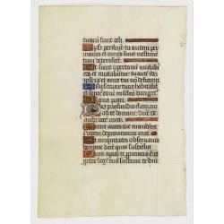
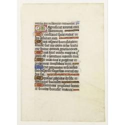
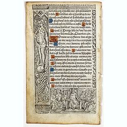
Leaf on vellum from a manuscript Book of Hours.
VERSO: one 2-line illuminated initial showing a bird in fine detail in liquid gold on colored ground, seven 1-line initials and line-fillers in same.RECTO: Seven 1-line i...
Place & Date: France, c. 1520
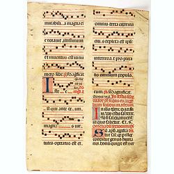
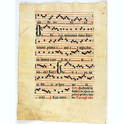
Leaf on vellum from a antiphonary.
A leaf from a Medieval Antiphonal or Choir Missal for Spanish use, in Latin on extremely heavy vellum. Justification: 360x246mm. Text is in Spanish rounded Gothic hand (R...
Place & Date: Sevilla, ca.1520

Leaf on vellum from a antiphonary.
A leaf from a Medieval Antiphonal or Choir Missal for Spanish use, in Latin on extremely heavy vellum. Justification: 360x246mm. Text is in Spanish rounded gothic hand (R...
Place & Date: Sevilla, ca.1520
Leaf on vellum from a antiphonary.
A leaf from a Medieval Antiphonal or Choir Missal for Spanish use, in Latin on extremely heavy vellum. Justification: 360x246mm. Text is in Spanish rounded gothic hand (R...
Place & Date: Sevilla, ca.1520
Leaf on vellum from a antiphonary.
A leaf from a Medieval Antiphonal or Choir Missal for Spanish use, in Latin on extremely heavy vellum. Justification: 360x246mm. Text is in Spanish rounded gothic hand (R...
Place & Date: Sevilla, ca.1520
![Claudii Ptolemaei Alexandrini mathematicor[um] ...Octo libri Geographie. . .](/uploads/cache/62656-250x250.jpg)
Claudii Ptolemaei Alexandrini mathematicor[um] ...Octo libri Geographie. . .
Third edition of "Géographie" by Ptolemy and published in Strasbourg. Illustrated with 50 maps engraved in wood. One of the more important maps is showing the ...
Place & Date: Strasbourg, J. Grüninger, 1522
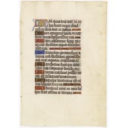
Leaf on vellum from a manuscript Book of Hours.
RECTO: One 2-lines initial decorated with flower in liquid gold on colored grounds and six 1-line initials in liquid gold on colored grounds and five line-fillers in same...
Place & Date: France, ca. 1530
Leaf on vellum from a manuscript Book of Hours.
RECTO: One 2-lines initial decorated with flower in liquid gold on colored grounds and seven 1-line initials in liquid gold on colored grounds and six line-fillers in sam...
Place & Date: France, ca.1530
![.Tabula III Asiae. [Caucass and Armenia.]](/uploads/cache/27894-250x250.jpg)
.Tabula III Asiae. [Caucass and Armenia.]
Ptolemaic map of the region south of the Caucasus Mountains and between the Caspian Sea as far south as the headwaters of the Tigris River in the south and the Black Sea,...
Place & Date: Lyons, M. Servetus, 1535
![.Taprobana Ins. Tabula XII Asiae. [Sri Lanka.]](/uploads/cache/27928-250x250.jpg)
.Taprobana Ins. Tabula XII Asiae. [Sri Lanka.]
Ptolemy's mythical island of Taprobana originally became associated with Sri Lanka although it was sometimes confused with Sumatra. Taprobana, as it was called on most ea...
Place & Date: Lyons, M. Servetus, 1535
![[Map of Palestine ]](/uploads/cache/42176-250x250.jpg)
[Map of Palestine ]
Map of Palestine from "La Mer des Hystoires" published by Dupré, Paris, 1536 "La Mer des Hystoires" is a translation into French of the famous "...
Place & Date: Dupre, Paris, 1536
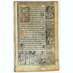
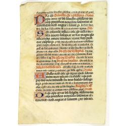
Leaf on vellum from a printed Book of Hours.
24 lines of printed text, surrounded by renaissance borders decorated with flowers, vases and religious scenes.From the press of the leading Parisian publisher and illumi...
Place & Date: Paris, Germain Hardouyn, c.1520-1540
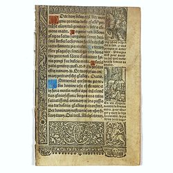
Leaf on vellum from a printed Book of Hours.
21 lines of printed text, surrounded by Renaissance borders decorated with flowers and little miniatures with figures on both sides.From the press of the leading Parisian...
Place & Date: Paris, Germain Hardouyn, c. 1520-1540
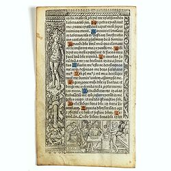
Leaf on vellum from a printed Book of Hours.
21 lines of printed text, surrounded by Renaissance borders decorated with flowers and little miniatures with figures on both sides.From the press of the leading Parisian...
Place & Date: Paris, Germain Hardouyn, c. 1520-1540
Leaf on vellum from a printed Book of Hours.
24 lines of printed text, surrounded by renaissance borders decorated with flowers, vases and religious scenes.From the press of the leading Parisian publisher and illumi...
Place & Date: Paris, Germain Hardouyn, c.1520-1540
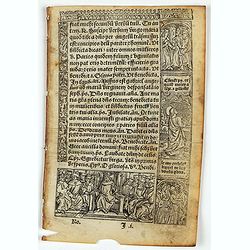
Leaf on vellum from a printed Book of Hours In Latin and French.
24 lines of printed text, surrounded by renaissance borders decorated with flowers, vases and figures. Gothic type, text in Latin, numerous one and two-line initials in g...
Place & Date: Paris, Germain Hardouyn, c. 1520-1540
Leaf on vellum from a printed Book of Hours In Latin and French.
24 lines of printed text, surrounded by renaissance borders decorated with flowers, vases and figures. Gothic type, text in Latin, numerous one and two-line initials in g...
Place & Date: Paris, Germain Hardouyn, c. 1520-1540
![.[India]](/uploads/cache/33861-250x250.jpg)
.[India]
Wood block printed map and one of earliest printed representation of India prepared by Martin Waldseemüller. Based on the slightly larger map from 1513 published in &quo...
Place & Date: Vienna, Trechsel, G., 1525 -1541
![[Taprobana - Sri Lanka]](/uploads/cache/33847-250x250.jpg)
[Taprobana - Sri Lanka]
Wood block printed map and one of earliest printed representation of Ceylon prepared Martin Waldseemüller.Based on the slightly larger map from 1513 published in "P...
Place & Date: Vienna, Trechsel, G., 1525 -1541

Tabula Sexta Asia (Arabian Peninsula)
This is a very desirable early Ptolemaic woodblock map of the Arabian Peninsula, here called Arabia Felix. The map is presented on a trapezoidal projection with par...
Place & Date: Vienna, 1525 -1541
![.[Pakistan, Afghanistan]](/uploads/cache/33849-250x250.jpg)
.[Pakistan, Afghanistan]
Wood block printed Ptolemaic map of the region of present-day Pakistan and part of Afghanistan. Convoluted mountain ranges and river systems dominate the trapezoidal map....
Place & Date: Vienna, Trechsel, G., 1525 -1541
![[Europe, Eastern, Sarmatia, Ukraine]](/uploads/cache/33854-250x250.jpg)
[Europe, Eastern, Sarmatia, Ukraine]
Wood block printed map and one of earliest printed representation of Europe, Eastern, Sarmatia, Ukraine prepared L. Fries after Martin Waldseemüller.Based on the slightl...
Place & Date: Vienna, Trechsel, G., 1525 -1541
![.[Italy]](/uploads/cache/33856-250x250.jpg)
.[Italy]
Wood block printed map and one of earliest printed representation of Italy prepared by Martin Waldseemüller. Based on the slightly larger map from 1513 published in &q...
Place & Date: Vienna, Trechsel, G., 1525 -1541

Tabula nova utriusque Indiae.
This is the fourth and last edition of this map based on Waldseemüller's first "modern" map of Asia. It follows that cartography without change but adds an int...
Place & Date: Vienne, 1541
![.[Near east with Cyprus]](/uploads/cache/33857-250x250.jpg)
.[Near east with Cyprus]
Wood block printed map and one of earliest printed representation of Near east with Cyprus prepared by Martin Waldseemüller. Based on the slightly larger map from 1513 p...
Place & Date: Vienna, 1525 -1541

Tabula Superioris Indiae & Tartariae maioris. (Modern Map of China, Japan, etc.)
Important map extending from Tartary in the north, to "Prov. Bocat" (Cambodia) in the south. "Tebet" is shown prominently, as is "Zinpangri"...
Place & Date: Vienne, 1541
![[India and China]](/uploads/cache/33875-250x250.jpg)
[India and China]
Wood block printed map and one of earliest printed representation of India and China prepared Martin Waldseemüller. Based on the slightly larger map from 1513 published ...
Place & Date: Vienna, 1525 -1541
![[East Asia]](/uploads/cache/33873-250x250.jpg)
[East Asia]
Wood block printed map and one of earliest printed representation of East Asia and centered on Amenia, prepared Martin Waldseemüller. Based on the slightly larger map fr...
Place & Date: Vienna, 1525 -1541
![.[Georgia (Republic), Sarmatia, Ukraine]](/uploads/cache/33870-250x250.jpg)
.[Georgia (Republic), Sarmatia, Ukraine]
Wood block printed map and one of earliest printed representation of Georgia (Republic), Sarmatia, Ukraine prepared by Martin Waldseemüller. Based on the slightly larger...
Place & Date: Vienna, Trechsel, G., 1525 -1541
![[Albania, Bulgaria, Europe, Eastern, Greece, Hungary, Macedonia, Romania]](/uploads/cache/33868-250x250.jpg)
[Albania, Bulgaria, Europe, Eastern, Greece, Hungary, Macedonia, Romania]
Wood block printed map and one of earliest printed representation of Albania, Bulgaria, Europe, Eastern, Greece, Hungary, Macedonia, Romania prepared Martin Waldseemülle...
Place & Date: Vienna, Trechsel, G., 1525 -1541
![.[Germany and Poland]](/uploads/cache/33862-250x250.jpg)
.[Germany and Poland]
Wood block printed map and one of earliest printed representation of Germany, Poland, The Low Countries, Austria and Switzerland prepared by Martin Waldseemüller. Based ...
Place & Date: Vienna, Trechsel, G., 1525 -1541