Browse Listings in Europe

Carte des routes de poste de la Russie européenne, exécutée par ordre de S.E.M. le duc de Feltre ministre de la Guerre, ...
Post-route map on a scale of 1:2 500 000 made during the French campaign in Russia, which began June 24, 1812. With a table of the conventional signs and a table of conve...
Place & Date: Paris, Dépôt Général de la Guerre 1812

Het Friessche Doolhoff, het beruchte dorp Molk-Worren
Uncommon map made in 1718 by Johannes Hilarides, principal at the Latin School in Bolsward.. Probably the only printed plan of a Frisian village of that time. The map was...
Place & Date: Amsterdam, 1705

Beschrijving Gezicht van den Ykant af bezyden den Schreiers hoex Toren langs de Keulsche en Geldersche Kaei naer de Nieuwe Markt
This large engraving (560x920mm.) comes from a are series of 25 beautiful large views of Amsterdam and gives a colorful picture of the life and business of the city at th...
Place & Date: Amsterdam, ca. 1720

Kaerte en Afbeeldinge vande Geheele Jurisdictie van Stantdarbuyten Gelegen in de Generaliteit onder Marquisaet van Bergen op den Zoom
With a large title cartouche with signature of the maker Adriaan van der Ende, : Kaerte en Afbeeldinge vande Geheele Jurisdictie van Stantdarbuyten Gelegen in de Generali...
Place & Date: Willemstad, 1737

Het Klooster ten Hage (Marienhage Eindhoven)
Very rare lithography of the ruin of the monastery of Ten Haghe in Eindhoven. Lithographed by M.Mouret, published in "oud-Nederland en de uit vroegere dagen overgebl...
Place & Date: Nijmegen, 1837-1846
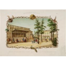
Rotterdamse Diergaarde. . .
Decorative view of Zoo of Rotterdam. To the right the house of the manager of the zoo. Decorated with personages in typical dress watching lions.
Place & Date: Amsterdam, 1860

Zelandia Comitatus.
Based on the map by Van Deventer. For the first time a road connection between Flushing, Middelburg and Arnemuiden is shown. Mercator pays much attention to the area of s...
Place & Date: Amsterdam, 1630
![[Set of 6 maps] Charta öfver Storfurstendömet Finland på Friherre S. G. Hermelins Anstalt och Omkostnad. Sammandragen och författad af C. P. Hällström. Philos. Magister och Auscultant i Kongl. BergsColl. 1799.](/uploads/cache/34482-250x250.jpg)
[Set of 6 maps] Charta öfver Storfurstendömet Finland på Friherre S. G. Hermelins Anstalt och Omkostnad. Sammandragen och författad af C. P. Hällström. Philos. Magister och Auscultant i Kongl. BergsColl. 1799.
This is the beautiful set of key map and separate maps of Samuel Gustav Hermelins map of Finland. The maps have been engraved by Fredrik Akrel, a very skilled and product...
Place & Date: Källa: J.Strang & E.- S. Harju: Suomen karttakirja 1799

Circoscrizione delle Provincie ecclesiastiche e Diocesi nei regni del Belgio, ed Olanda (Tav LXI)
This large-format map showing Belgium and Holland with its different dioceses. The map is finely engraved and beautifully colored and was prepared by Girolamo Petri, a la...
Place & Date: Rome, 1858

London in Miniature With The Surrounding Villages. An Entire New Plan In which the Improvements both present and intended are actually reduced, by permission, from the surveys of the Several Proprietors. . .
Hand-coloured engraved map, dissected and mounted on linen, orange publishers label on one side, extending west to east from Kensington to East India and Greenwich Dock a...
Place & Date: London, 1821