Browse Listings

Les Villes forts et châteaux de Malte capitale de l'isle de ce nom. Dessignée sur le lieu par un Ingr du roy.
A very decorative and extremely rare town-view of Valetta, including a numbered legend in lower part. Published by Jacques Chereau, (1688 - 1776). Engraved by Aveline and...
Place & Date: Paris, ca.1750

Nouvelle Mappa Monde.
State 2 of this fine double hemisphere world map, from an unusual perspective, with a "Mer de L'Ouest" or "Sea of the West". Paris is located at the c...
Place & Date: Venice, 1776 - 1784

Pas-Kaat vaneen gedeelte van de Aethiopische Zee behelsende de Kusten Zanguebar, Ajan en Abex, en een gedeelte van de Arabische Kust. . .
A finely engraved and detailed chart of the most eastern tip of Africa, including Somalia, Djibouti, Yemen, Mauritius, and many other islands in the Indian Ocean.Very rar...
Place & Date: Amsterdam, 1753

Tabula Prima Africa.
The map apart from depicting Morocco also shows southern Spain and the Balearic Islands. In north Africa the map extends eastwards toward modern day Algeria and to the we...
Place & Date: Strasbourg, 1513

Paris.
A spectacular panoramic view of Paris, with legends numbered from 1-70 in French. With the title in a banderol.After a design by Friedrich Bernhard Werner (1690-1776) who...
Place & Date: Augsbourg, ca. 1740
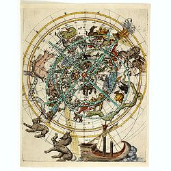
(Northern celestial planisphere with a pasted volvelle.)
Probably by the Vienna astronomer Melchior Klayber who used the Copernican precession theory, which is closely connected with the chart (Ptolemy - 6° 40' and Ptolemy - 5...
Place & Date: Vienna, ca. 1569
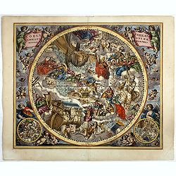
Coeli Stellati Christiani Haemisphaerium Prius.
Scarce first issue. This spectacular celestial chart presents the constellations according to Christian symbolism. The view of the constellations is based on the work of ...
Place & Date: Amsterdam, 1660

Nieuwe en zeer accuraate Zee-Caart van de Hollandse Wal strekkende van de Maas tot Texel opgenomen door Jan Rokusz Douw, , ,
A very fine and rare chart of the coast of Holland, Prepared by Jan Rokusz, Douw and Agge Roskam Kool.Embellished with a very decorative cartouche with a dedicational tex...
Place & Date: Amsterdam, 1750

Pascaerte vande Caribische Eylanden, vande Barbados tot aende Bocht van Mexico ‘t Amsterdam By Hendrick Doncker. . .
First state. Rare. “This chart appeared in the first edition of Hendrick Doncker’s Zee-Atlas, of which no surviving example is known” -- Burden. This is an example ...
Place & Date: Amsterdam, 1659

Frisia occidentalis.
A rare separately published carte-a-figures of Friesland by Geelkercken in its first state. The title and the coats of arms of the eleven Frisian towns appear in the cent...
Place & Date: [Leeuwarden], Dierick Albertsen, 1618