Funeral in China.
A scene of a funeral in China from Linschoten's famous voyages to the East of 1583-92 here published by De Bry the year after they first appeared as a separate book. From...
Place & Date: Frankfurt, 1599

Habillement de l'Empereur de la Chine & des Dames de son Palais..
This impressive engraving is a wonderful example of Chatelain’s elegant plates.Divided in 3 panels, showing examples of costumes of Chinese ladies and those of the king...
Place & Date: Amsterdam, ca. 1728
![Carte du Tche-Kiang. [ Zhejiang province ]](/uploads/cache/30921-250x250.jpg)
Carte du Tche-Kiang. [ Zhejiang province ]
Map of Tche Kiang, prepared by Bishop Edmond-François Guierry, C.M. (Vicar Apostolic of Zhejiang, China) after sources supplied by missionaries. Published in "Les M...
Place & Date: Paris, 1874

Carte du Kouy-Tchéou.
Detailed map of Guizhou Province prepared by Mgr. Faurie and other sources supplied by missionaries. Published in "Les Missions Catholique". Engraved by P. Méa...
Place & Date: Lyon, c.1874
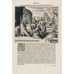
Feast of China.
A scene of a Chinese dinner feast from Linschoten's famous voyages to the East of 1583-92 here published by De Bry the year after they first appeared as a separate book. ...
Place & Date: Frankfurt, 1599
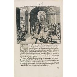
Punishment of a criminal in China.
Punishment of a criminal in China from Linschoten's famous voyages to the East of 1583-92 here published by De Bry the year after they first appeared as a separate book. ...
Place & Date: Frankfurt, 1599
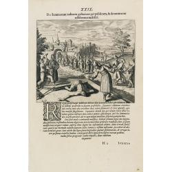
Punishment of China.
The Chinese way of a punishment from Linschoten's famous voyages to the East of 1583-92 here published by De Bry the year after they first appeared as a separate book. Fr...
Place & Date: Frankfurt, 1599

Partie de la Chine N°87. (Covers Jiangxi, Fujian and parts of Zhejiang, Guangdong, Hunan and Hubei.)
Covers Jiangxi, Fujian and parts of Zhejiang, Guangdong, Hunan and Hubei.From his famous Atlas Universel . This atlas was one of the most remarkable world atlases ever pr...
Place & Date: Brussels, 1825-1827

Partie de la Chine N°86. (Covers Guizhou and parts of Yunnan, Guangxi, Hunan, Hubei and Sichuan.)
Covers Guizhou and parts of Yunnan, Guangxi, Hunan, Hubei and Sichuan.From his famous Atlas Universel . This atlas was one of the most remarkable world atlases ever produ...
Place & Date: Brussels, 1825-1827

The Empire of China and Island of Japan. . .
The map is of interest for the use of East Sea, the sea between Korea and Japan, here called "Sea of Corea". Some interesting notations are made. From his atlas...
Place & Date: London, 1736

Designs for two porcelain bowls with Chinese design.
With numbers 4.601, 4.818. In top "Planche N° d'ordre : 03004.Original design created by the Sevres artist Gabriel Fourmaintraux ( 1886 - ) at about 1910 to serve a...
Place & Date: Desvres, 1905 - 1925

Map of China.
Showing China, Taiwan and Korea, divided into provinces with the main cities marked. The map is of interest for the use of Sea of Corea, the sea between Korea and Japan, ...
Place & Date: London, 1804

Charte von China und den angränzenden Ländern und Völkerschaften so wie den letzten Kaiser Tschien-Long. . .
Uncommon map of China on a scale of ca. 1:6,000,000. The map's complete title is “Charte von China und den angränzenden Ländern, und Völkerschaften so wie sie dem le...
Place & Date: Parague, 1812
Selling price: $400
Sold in 2023

Designs for porcelain plate with Chinese design.
In right hand side "Planche d'aquarelle N° 06502". And the numbers 11.153, 11.154, 11.155. Original design created by the Sevres artist Gabriel Fourmaintraux (...
Place & Date: Desvres, 1905 - 1925

Designs for Porcelain ware with Chinese design.
In left hand side "Planche d'aquarelle N° 05501". Original design created by the Sevres artist Gabriel Fourmaintraux ( 1886 - ) at about 1910 to serve as guide...
Place & Date: Desvres, 1905 - 1925

A new & accurate map of the Empire of China from the Sieur Robert's Atlas. With improvements.
An excellent early engraving of China and Korea that appeared in Sieur Robert de Vaugondy's Geographical Dictionary (London: 1759). Decorative title cartouche on the uppe...
Place & Date: London, 1759
![Nankin [Nanjing, Jiangsu]](/uploads/cache/30031-250x250.jpg)
Nankin [Nanjing, Jiangsu]
Very detailed (1:1.000.000) map showing the area north of Nanjing, Jiangsu. The French Service géographique des armées was founded in 1887 and provided the French milit...
Place & Date: Paris, 1900

Nuova carta dell' Imperio della Chia e dei Paesi circonvicini. / Nueva carta de l'Impario de la Quina.
The map is of interest for the use of Mar di Corea" and "Mar Setentrionale del Giapone" in the sea between Korea and Japan.Rare early edition of Albrizzi's...
Place & Date: Venice, 1740

Vue perspective de la grande Ceremonie du Couronnement de l'Empereur de la Chine.
So-called optical print illustrating the crowning of the Chinese emperor. It shows the throne at the center.Mondhare was a well-known publisher of optical prints, establi...
Place & Date: Paris, 1761

La China e Giapone.
Uncommon map of China, Korea, Japan and Taiwan (I.Formosa), only one town labeled, Tayoan. Very strange shape for Japan.The map is of interest for the use of Mar di Corea...
Place & Date: Italy, ca. 1800

Partie de la Chine. N°.74 (Including South Korea)
Covering the Mouth of the Yangtze area in Jiangsu and Zhejiang, and southwestern Korea with the island of Quelpart (Jeju-do). Shows explorers' routes, including La Perou...
Place & Date: Brussels, 1825-1827

Reis-kaart van het Britsche gezantschap van Hang-choe-foe naar Quang-choe-foe of Kanton in China.
Uncommon map of eastern part of China, showing a journey of the English Embassy from Hangzhou (south of Shanghai) to Guangzhou (Canton). The maps is giving a wealth of in...
Place & Date: Netherlands, c.1800

Designs for porcelain vase with Chinese motif.
With attractive pattern of a classic Chinese motif. In top "Planche d'aquarelle N° 04510" and the numbers 2,198. Original design created by the Sevres artist G...
Place & Date: Desvres, 1905 - 1925

Designs for porcelain vases with Chinese motif.
Hand colored design of 13 vases with attractive patterns of a classic Chinese motif. In right "Planche d'aquarelle N° 04004" and the numbers 7.404, 2.074, 8.93...
Place & Date: Desvres, 1905 - 1925

A view of the town and castle of Macao.
A nice engraving that shows the attack of the English ship "Centurion" on Macau, during which she captured a Portuguese ship that had sailed from Manila. In up...
Place & Date: London, 1746

CANTON Kong-Teheou.
Very detailed (1:1.000.000) map centered on Macao and Victoria Island, showing soundings, English, Australian, Danish telegraph lines reaching Hong Kong and extended to M...
Place & Date: Paris, 1898 updated for june 1904

Key Map of Hong Kong Relative to Canton and Macao.
A nice folded map of Hong Kong and the surrounding areas. Produced by the British Crown Lands Survey Office just after WWII. Physical features are shown by contour. Railw...
Place & Date: Hong Kong, 1948

Standford's map of the empires of China and Japan with the adjacent parts of the Russian Empire, India, Burma &c.
Charming, folding map of China and Japan with the adjacent parts of the Russian Empire, India, and Burma. A key identifies railway lines in red, projected railway lines i...
Place & Date: London, ca. 1911

Iunan, Queichev, e Quangsi Provincie della Cina. . .
A beautiful map depicting the area of Beijing with decorative title cartouche and scale cartouche. Information about the area at the top of the map.The remarkable Vincenz...
Place & Date: Venice, 1690

Huquang, Kiangsi, Chekiang ac Fokien.
A reissue of Janssonius' map of south east China, with wash color and uncolored cartouches.The map is based on the maps of Martin Martini, themselves based on Chinese sou...
Place & Date: Amsterdam, 1720

Hong Kong.
Decorative poster advertising flights to Hong Kong made by Georges Mathieu. The poster is one of a series of 15 composed of posters of Greece, Israel, Germany, Great Bri...
Place & Date: Paris, 1967
![Kantong [The Dutch Folly Fort off Canton]](/uploads/cache/05714-250x250.jpg)
Kantong [The Dutch Folly Fort off Canton]
Charming 18th water color on paper depicting The Dutch "Folly Fort" off Canton. Probably made by a western artist visiting China.Forts were built in several pla...
Place & Date: Canton?, c.1750

L'Empire de la Chine. . .
Detailed map of China, Korea and Taiwan. The large title cartouche is resplendent in the French style with musicians, a dancer, and various accouterments representative o...
Place & Date: Paris, dated 1750

Fokien Imperii Sinarum Provincia undecima.
The province of Fokien lies opposite Taiwan and south of the region described in the above map. The coast is shown from Wen-zhou in the north to Fu-zhou and as far south ...
Place & Date: Amsterdam, 1660

Kancheu.
Charming 18th water color on paper depicting Kancheu. Probably made by a western artist visiting China.
Place & Date: c.1750

A chart of the China Sea inscribed to Monsr. D'APRES de MANNEVILLETTE .. To A.Dalrymple.
Most important milestone chart is based upon the surveys made from navigational surveys by Alexander Dalrymple (1737-1808]. He was the first hydrographer of the British A...
Place & Date: Paris, ca 1775

Hedendaegsche Historie of tegenwoordige staet van alle volkeren 1 deel. (Volume 1 - China, Japan, Phillippines, Moluccas)
This provides an interesting illustrated description of China, Japan, the Phillippines, Moluccas. Including a map of China, Korea, and Japan, with the Sea between Korea a...
Place & Date: Amsterdam, 1734

Pecheli, Xansi, Xantung, Honan, Nanking, In plaga Regni Sinensis. . .
A map of the northern provinces of China after the Jesuit Martino Martini, depicting of Hebei (Pecheli), Shanxi (Xansi), Shandong (Xantung), Henan (Honan), and Jangsu (Na...
Place & Date: Amsterdam, ca 1660

China Veteribus Sinarum Regio.
Based on Jesuit surveys, the map represents the next major revision in the cartography of China after Ortelius' 1584 map. Korea, however, is still an island, and Japan co...
Place & Date: Amsterdam, 1640
![[India and China]](/uploads/cache/33875-250x250.jpg)
[India and China]
Wood block printed map and one of earliest printed representation of India and China prepared Martin Waldseemüller. Based on the slightly larger map from 1513 published ...
Place & Date: Vienna, 1525 -1541