Browse Listings in Asia
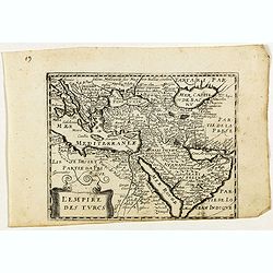
L'Empire des Turcs.
Rare map of the Turkish empire, published by Jollain in 1667. Published in "Trésor Des Cartes Geographiques Des Principaux Estats de Lunivers".Showing "&q...
Place & Date: Paris, 1667

Paskaerte Zynde t'Oosterdeel Van Oost Indien, met alle de Eylanden daer ontrendt geleegen van C. Comorin tota aen Iapan.
An eye-catching chart of Pieter Goos' sea chart of Australia, Southeast Asia, China, Japan, Korea and India. The chart shows the regions from Cape Comorin (Southern India...
Place & Date: Amsterdam, 1669

An embassy from the East-India Company of the United Provinces, to the Grand Tartar Cham, Emperor of China deliver'd by their excellencies, Peter de Goyer and Jacob de Keyzer, at his imperial city of Peking. . .
Very rare first English text edition of this most important and early resource on China and the Chinese. Three parts in one folio by John Macock for the author.Part I: An...
Place & Date: London : Printed by the Author at his house in White-Friers, 1669

La Chine d'Athanase Kirchere de la compagnie de Jesus, illustrée de plusieurs monuments tant sacrés que profanes et de quantité de recherches de la nature. . .
Athanasius Kircher, S.J., (1601 or 1602-1680) was a 17th-century German Jesuit scholar who published around 40 works, most notably in the fields of oriental studies, geol...
Place & Date: Amsterdam, 1670
![Via Bethleem. [The route from Jerusalem to Bethlehem ]](/uploads/cache/30800-250x250.jpg)
Via Bethleem. [The route from Jerusalem to Bethlehem ]
The route from Jerusalem to Bethlehem. Below a lettered key. Taken from a very rare travel book by Anthonius Gonsales, "Hierusalemsche Reyse". The book describe...
Place & Date: Antwerpen, Michiel Cnobbaert, 1673
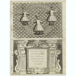
Turckschemoniken die onder den goddelycken. . .
Decorative picture of three dervishes dancers. Their whirling dance, also known as the sema, is a serious religious ritual performed by Muslim priests in a prayer trance ...
Place & Date: Antwerpen, Michiel Cnobbaert, 1673
![Rama. [Ramah]](/uploads/cache/30789-250x250.jpg)
Rama. [Ramah]
Town plan of Ramah, about 5 miles (8 km) from Jerusalem and near to Gibeah. Below a decorative cartouche with numbered key and surrounded by 2 cherubins.Taken from a very...
Place & Date: Antwerpen, Michiel Cnobbaert, 1673

Nazareth.
Decorative view of Nazareth, below a decorative cartouche with numbered key and surrounded by 2 cherubins. Taken from a very rare travel book by Anthonius Gonsales, "...
Place & Date: Antwerpen, Michiel Cnobbaert, 1673

Arabie.
Uncommon miniature map of the Arabian peninsula, from Pierre Duval's La Geographie Universeille dated 1676. Following his Cartes de géographie in 1657, Pierre Duval publ...
Place & Date: Paris, 1676
Reiß in das Gelobte Land ... Mit nach dreyen andern Reißbeschreibungen vermehret, und schönen Kupfern gezieret.
Very rare first illustrated edition of collected travel accounts by citizens of Zürich, containing : Hans Jacob Amman, "Narrative of a trip to Palestine". The ...
Place & Date: Zürich, M. Schauffelberger Erbin, 1678

Carte des Isles du Japon Sequels est remarque la Route..
This uncommon map of Japan, a reduced version of his larger map, contains comments about the nature of the country. For instance, Ocsaqui (Okazaki, near Nagoya) is said t...
Place & Date: Paris / Amsterdam, 1679

Carte des Isles du Japon Esquelles est remarque la Route..
This uncommon map of Japan, which is on a fairly large scale, contains comments about the nature of the country. For instance, Ocsaqui (Okazaki, near Nagoya) is said to h...
Place & Date: Paris 1679

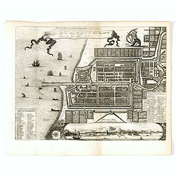
Waere affbeeldinge wegens het casteel ende stadt Batavia.
A good impression of this finely engraved and detailed plan of Batavia, present-day Jakarta, the Dutch center of trading activities in the East Indies. Copied after Cleme...
Place & Date: Amsterdam, 1681
-250x250.jpg)
Hern Johann Baptisten Taveniers..Vierzig Jaehrige Reize..
This German edition includes Tavernier's map of Japan in a reduced form (210x315mm) and contains legends about the country's nature, e.g., where gold is mined and plottin...
Place & Date: Nuremberg, 1681

Il regno della China detto presentente Catay e Magnin. . .
A rare and decorative Italian map of China and Japan, with Japan closely modelled on the indented Cardim outline and Hokkaido, called Yuppi , shown as an Asian peninsula....
Place & Date: Rome, 1682
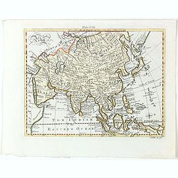
Asia.
Detailed map the Asian continent. The map is of interest for the use of Sea of Corea, the sea between Korea and Japan.
Place & Date: Amsterdam, 1682
Selling price: $225
Sold in 2023

Het Beloofde Landt Canaan door wandelt . . .
A beautifully engraved map of the ancient land of Canaan which roughly corresponds to present-day Israel. Cherubs hold up a draped cloth of key symbols, also a scale pane...
Place & Date: Amsterdam, 1682

Jerusalem.
Engraved by Bastiaan Stoopendaal from Juan Bautista Villapando's imaginary town-plan of Jerusalem. This bird's-eye view is surrounded by 12 scenes, views and portraits of...
Place & Date: Amsterdam, 1682

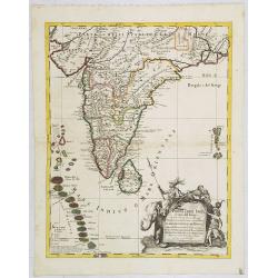
Indiae extra Gangem Pars Septentrionalis. Indiae extra Gangem Pars Meridionalis.
The map on the left depicts the northern portion of the India Ganges region, representing Burma (Myanmar), Thailand, Cambodia, Vietnam and Laos. The right one depicts th...
Place & Date: Utrecht / Amsterdam, J.Halma, 1683

Le Grand Mongol. . .
Rare full portrait of the Mongol emperor of Indostan, published by map seller, François Jollain, the Elder (1641-1704), active in Paris, rue St. Jacques à la ville de C...
Place & Date: Paris, ca. 1686
Penisola dell India di là dal Gange et Isole intorno ad essa adiacenti..
Giacomo Rossi's fine late 17th century map of India with Ceylon and Maldives. Issued in Il Mercurio geografico In lower right hand corner a large title cartouche with ded...
Place & Date: Rome, 1683-1688
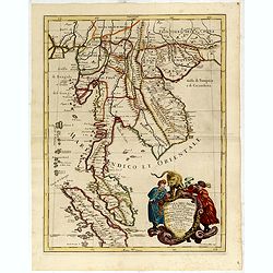
Penisola Dell India di la dal Gange Diusa ne i Regni, che in essasi contengono et accresciuta di varie notizie. Da Giacomo Cantelli da Vignola e conforme le Relationi di alcuni Padri della Compa di Giesu di Monsu Tavernier . . . 1683
Giacomo Rossi's fine late 17th century map of Malaysia, Thailand, Cambodia and part of Sumatra.. Engraved by Franciscus Donia. Issued in Il Mercurio geografico In lower r...
Place & Date: Rome, 1683-1688

Mocha, in Arabien. (View of Mocha, Yemen.)
Magnificent bird's eye-town-view of Mocha in Yemen.. Etched by Gaspar Bouttats (1640-1695).The Antwerp based publisher Jacques Peeters published ca. 1690 a series of prin...
Place & Date: Antwerp, c.1690

Iunan, Queichev, e Quangsi Provincie della Cina. . .
A beautiful map depicting the area of Beijing with decorative title cartouche and scale cartouche. Information about the area at the top of the map.The remarkable Vincenz...
Place & Date: Venice, 1690

Quantung, e Fokien, Provincie della China...
A beautifully engraved decorative map of Southern China extending from Hainan in the West to Formosa in the East and centered on the Pearl River Delta with Macao and the ...
Place & Date: Venice, 1691

Isola del Giapone e penisola di Corea.
A most attractive and decorative map by Vincenzo Coronelli. An elaborate central title cartouche garlanded with intertwined flowers and dedicated to the Rev.de Fontaine o...
Place & Date: Venice, 1692
![[Arabia]](/uploads/cache/40143-250x250.jpg)
[Arabia]
A lovely miniature map of the region of Armenia and Georgia, showing both parts of the Black Sea and Caspian Sea. For such a small map it renders a wealth of detail, with...
Place & Date: Ulm, 1692

Het gezandtschap der Neerlandtsche Oost-Indische Compagnie, aan den grooten Tartarischen Cham, Den tegenwoordigen Keizer van China. . .
Third edition of this beautifully illustrated work on China. The first edition was published in 1665.Jan Nieuhof was a "Dutch traveler and adventurer" (1618-72)...
Place & Date: Amsterdam, W. Waasberge, 1693

Parte orientale della China.. / Parte occidentale della China. (2 sheets)
The map depicts the eastern part of China with Korea -correctly- as a peninsula. Formosa is included as well. Japan is partly visible i.e. the area of Yamaguchi, strait K...
Place & Date: Venice, 1695

Isole dell'Indie. . .
A beautiful and flamboyantly engraved large-scale map of the East Indies, including the Malay Peninsula, Cambodia, the Philippines and all of Indonesia and the Spice Isla...
Place & Date: Venice, 1696

Chorographia Terrae Sanctae in Angustiorem. . .
Rare. Large visually rich map decorated with illustrations of the sacred objects and places of Judaism. In the bottom center is a plan of ancient Jerusalem, and the route...
Place & Date: Amsterdam, ca. 1700
![Le Royaume de Siam avec Les Royaumes Qui Luy sont Tributaries & c. / La Royaume de Siam avec les royaumes qui luy sont Tributaires, et les Isles de Sumatra, Andemaon, etc. . . [two sheet map]](/uploads/cache/40698-250x250.jpg)
Le Royaume de Siam avec Les Royaumes Qui Luy sont Tributaries & c. / La Royaume de Siam avec les royaumes qui luy sont Tributaires, et les Isles de Sumatra, Andemaon, etc. . . [two sheet map]
Influential map of Southeast Asia and the East Indies including modern day Thailand, southern Vietnam, Cambodia, Malaysia, Singapore, Borneo, Sumatra and Java. Ottens inc...
Place & Date: Amsterdam, 1710

De Stadt Jerusalem.
Plan of ancient Jerusalem from a Dutch bible after Villalpando. The print is in contemporary colors, which is extremely rare for a plate like this. Lower left the Temple ...
Place & Date: Amsterdam, 1710

De golf van Bengalen.
Rare chart of the Indian Ocean, with nice detail on Ceylon (Sri Lanka) with compass roses and a system of rhumb lines, soundings and anchorage's. Many place names. The pl...
Place & Date: Amsterdam, after 1669-1712

Paldobundo Province.
Woodblock printed map of Jeolla Province which was one of the historical Eight Provinces of Korea during the Kingdom of The map is drawn in "Paldo Bundo," styl...
Place & Date: 1710-1718
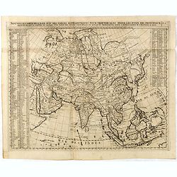
Nouvelle Carte De L'Asie Avec Des Tables Alphabetiques Pour Trouver Sans Peine Les Etats Des Principaux Princes De Cette Partie Du . . .
Chatelain's map of Asia. The title is in two lines across the map. On each side border appears an index to the map's contents.The map is of interest for the use of Mer Or...
Place & Date: Amsterdam, 1719
Waere affbeeldinge wegens het casteel ende stadt Batavia.
A good impression of Batavia's finely engraved and detailed plan, present-day Jakarta, the Dutch center of trading activities in the East Indies. Copied after Clement de ...
Place & Date: Leiden, 1719

Carte du Golfe de Bengale, mer des Indes et rivieres du Gange . . .
Detailed scare map of the Southern part of India with Ceylon. Good detail along the coasts of Malabar, Coromandel, the Maldives islands and the Kingdoms of Visipour, Golc...
Place & Date: Leide, 1719

Carte des Principales Ports de Mer Bancs de sable &c: qui sont dans la Mer Rouge..
Some cities existed along the western coast of the Arabian peninsula, where they served as entrepots for transcontinental trade between Europe and Asia. Mecca, founded by...
Place & Date: Amsterdam, 1720

Japonia Regnum.
It is the first map to correctly show Korea as a peninsula. The rare Covens and Mortier issue of this important map of Japan and Korea, originally published by Blaeu. Thi...
Place & Date: Amsterdam, 1655 - 1720