Browse Listings

Vue de Malthe du cote du Fort.
A so-called optical print of Valletta seen from the castle. This rare optical print shows people in typical French dresses in the foreground and placed in boats.In the ei...
Place & Date: Paris, 1798

Costumes des habitans de Manille.
A very beautiful print, showing four elegant figures relaxing in a shady glade, two women recline and two stand chatting.After a design of Duché de Vancy and engraved by...
Place & Date: Paris, 1798

Vue de cavite dans la Baie de Manille.
Two boats and passengers with Cavite Philippines in the background as if was seen from Manila Bay in January 1787. After a design of Gaspard Duchè de Vancy and engraved ...
Place & Date: Paris, 1798

(Untitled view from Scutari with a view of Constantinople)
Panoramic view from Scutari with a view of Constantinople in the distance, after a design by Johann Schranz. Published by J. Missiriè.
Place & Date: Paris, 1860

Die Stadt Narva. . .
An early of the town of Narva, located at the eastern tip of Estonia, on the Russian border.From the uncommon Hamburg edition "Viel Vermehrte Moscowitische und Pers...
Place & Date: Hamburg, 1696

Lutzenburgensis Ducatus veriss descript.
Prepared by Jacob Surhon who made a manuscript map of Luxembourg for which he received 500 Livres from Charles V in 1551. For security reasons the map was not published. ...
Place & Date: Antwerp, 1609
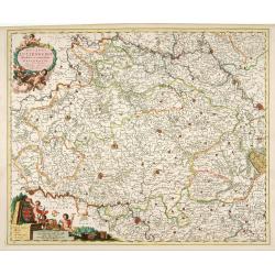
Ducatus Lutzenburgi Novissima et Accuratissima Delineatio.
West to the top. Very detailed and fine map of Luxembourg, including the towns of Namur, Liege, Trier and Metz.
Place & Date: Amsterdam, 1680

Vuë de l'ancien Palais d'hiver de sa Majesté Imperiale et du Canal qui Joint la Moika avec la Neva, a St. Petersburg.
So-called optical print illustrating a perspective view of St. Petersburg, namely the ancient Winter Palace and the canal which joins the Moika to the Neva.In the eightee...
Place & Date: Paris, 1760

Carinthiae et Goritiae... / Histria tabula.../ Zarae, et Serebenici ..
Three maps on one sheet. The left hand is centered on the eastern part of Austria. The right upper hand map is centered on northern Yugoslavia, and the last map is center...
Place & Date: Antwerp, 1598

Plan der Stadt Quebec Haupstadt in Neu Franckreich oder Canada.
Town-plan of Quebec, with an inset view of the town in the lower right corner. In the upper right a recapitulation of the main military actions prior to the surrender of ...
Place & Date: Nurnberg, 1770