Browse Listings in Atlases
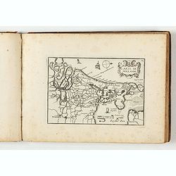
Carte Generalles des Royaumes & Provinces, de la haute et basse Allemagne, Reveües et Corigées, par le Sr. Tassin, Geographe Ordinaire de Sa Ma.té.
Illustrated with 51 (of 52) maps of The Netherlands, Belgiem, Germany, France, Poland, Bohemia...Christophe Tassin, who was active from 1633 till 1655, was appointed 'roy...
Place & Date: Paris, [Sébastien Cramoisy], 1633

Novus de Leone Belgico eiusq topographia atq. Historica descriptione liber (…). Rerumque in Belgio maxime gestarum, inde ab anno Christi M.D.LIX. Usque ad annum M.D.LXXXVII perpetua narratione continatus.
ENLARGED EDITION, with 207 (of 208) engravings of a famous eyewitness account of the Dutch Revolt, with the famous "Leo Belgicus" map, here in its second state...
Place & Date: Cologne, Gerardus Campensis for Frans Hogenberg, 1588
![[Two vomlumes, with two Leo maps] De Bello Belgico, Decas Prima / Decas Secunda.](/uploads/cache/48779-250x250.jpg)
[Two vomlumes, with two Leo maps] De Bello Belgico, Decas Prima / Decas Secunda.
With 2 engraved titles of the 'Leo Belgicus', with one paw resting on a shield bearing the title, large woodcut printer's device on the colophons, and 30 richly engraved ...
Place & Date: Rome, Franciscus Corbelletus, 1632-1647
![Ch'onha chido.[Atlas of all under Heaven]](/uploads/cache/44639composition-world-250x250.jpg)
Ch'onha chido.[Atlas of all under Heaven]
A late 18th century Ch'onha chido atlas with 13 woodblock maps showing the World, China, Korea, Japan, Okinawa, and the 8 provinces. The seas are in black.
Place & Date: Korea, ca. 1760
Histoire de la Navigation.
A fine example of Linschoten's classic illustrated travelogue to the East and West Indies, termed by Lach “the most important of the firsthand accounts published indepe...
Place & Date: Amsterdam, Evert Cloppenburgh, 1638
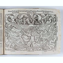
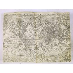
Cosmographie, ou description des quatre parties du Monde...
Fourth French edition (first French collective edition), considerably enlarged with the double-page truncated cordiform world map "Charte cosmographique", in us...
Place & Date: Antwerp, Jean Bellere, a l'Aigle d'Or, 1581
![Theatrum praecipuarum urbium Ducatus Brabantiae. / bound with : [Hogenbergs Geschichtsblätter].](/uploads/cache/48788-250x250.jpg)
Theatrum praecipuarum urbium Ducatus Brabantiae. / bound with : [Hogenbergs Geschichtsblätter].
Volume including two series :1st series : [Schut, Pieter Hendricksz]. Theatrum praecipuarum urbium Ducatus Brabantiae… Illustrated with an engraved title page and 43 pl...
Place & Date: (Amsterdam), N. Visscher, 1657 / Cologne, 1566-1579
![(Chatelain "Atlas Historique" in 7 volumes.]](/uploads/cache/47053X-250x250.jpg)
(Chatelain "Atlas Historique" in 7 volumes.]
Henri Abraham Chatelain, whose Atlas Historique was one of the most expansive encyclopedias of the age. First published in 1705, Chatelain's Atlas Historique was part o...
Place & Date: Amsterdam: Chez Zacharie Châtelain, 1732 - 1739
![[Collection of six maps of Australia and New Zealand.]](/uploads/cache/48412-250x250.jpg)
[Collection of six maps of Australia and New Zealand.]
Collection of maps including 6 engraved maps by 19th century German, French and English cartographers depicting Australia and New Zealand.This made to order atlas contain...
Place & Date: Germany, 1832-1852

Atlas des Missions de la Société des Missions-Étrangères. . .
This scarce atlas contains maps showing the locations of the Catholic missions belonging to the Société des Missions Étrangères in Asia. It covers India, Burma, Siam,...
Place & Date: Lille, 1890