Browse Listings

Constantinopolis.
A spectacular woodcut panorama of the ancient city of Constantinople, proporting to show the pre-Turk city (for example naming St Sophia). (235x522mm).One of the earliest...
Place & Date: Nuremberg, 12 July 1493
![Ulma Folio CXCI [With view of Ulm.]](/uploads/cache/29713-250x250.jpg)
Ulma Folio CXCI [With view of Ulm.]
Double page panoramic view of Ulm.A imaginary view, however the earliest obtainable view of this period.Two page from the richest illustrated Incunabel, the famous: Nurem...
Place & Date: Nuremberg, 12 July 1493

Sexta Etas Mundi. Folium. CCXVII (dancers of Maastricht).
Latin text page with woodcuts of male Siamese twins, a man headed lion. The large illustration is the only illustration related to the Netherlands : it shows a bridge col...
Place & Date: Nuremberg, 12 July 1493
![Carthage, etc. [Foliu XL ]](/uploads/cache/26122-250x250.jpg)
Carthage, etc. [Foliu XL ]
VERSO: Portraits of scholars, and an imaginary view on Carthage in Tunisia (12x17cm.) Page from the famous Liber chronicarum of Hartmann-Schedel 1493, the first and Latin...
Place & Date: Nuremberg 12 July 1493
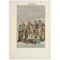
Sexta Etas Mudi. / Simon Beatus .. / Folio CCLIIII.
A very fine presentation of the circumcision of Simon (192 x 223 mm.). RECTO: a falling star, a portrait of a King and an officer wearing armour. Page from the richest il...
Place & Date: Nuremberg, 12 July 1493
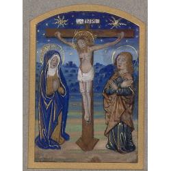
Miniature of The Crucifixion of Christ.
Page fragment from a Book of Hours with a miniature of the Cruxifiction with Saint Mary and Mary Magdalene in prayer in front of Jesus hung on the cross. This miniature c...
Place & Date: Paris, 1492 - 1494

Quinta Asie Tabvla.
Woodblock map of Persia from Martin Waldseemüller's 1513 edition of Ptolemy, a landmark work that contributed to major advances in both Renaissance geography and map p...
Place & Date: Strasbourg, J. Schott, 1513

Tabula Prima Africa.
The map apart from depicting Morocco also shows southern Spain and the Balearic Islands. In north Africa the map extends eastwards toward modern day Algeria and to the we...
Place & Date: Strasbourg, 1513

Tabula Secunda Europe (Spain & Portugal)
Wood block printed large-format Ptolemaic map of the Iberian Peninsula from the 1513 edition of Waldseemüller's Geographia.This Ptolemaic map comes from the first so cal...
Place & Date: Strasburg, 1513
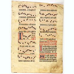
Leaf on vellum from a antiphonary.
A leaf from a Medieval Antiphonal or Choir Missal for Spanish use, in Latin on extremely heavy vellum. Justification: 360x246mm. Text is in Spanish rounded Gothic hand (R...
Place & Date: Sevilla, ca.1520