Search Listings matching "australia"

Novus de Leone Belgico eiusq topographia atq. Historica descriptione liber (…). Rerumque in Belgio maxime gestarum, inde ab anno Christi M.D.LIX. Usque ad annum M.D.LXXXVII perpetua narratione continatus.
ENLARGED EDITION, with 207 (of 208) engravings of a famous eyewitness account of the Dutch Revolt, with the famous "Leo Belgicus" map, here in its second state...
Place & Date: Cologne, Gerardus Campensis for Frans Hogenberg, 1588

Maris Pacifici.
From the rare Dutch text edition of the Theatrum of which according to van den Broecke only 100 copies are printed.This was the first printed map to be devoted solely to ...
Place & Date: Antwerp, 1598

Nova Totius Terrarum Orbis Geographica..
The first of four states of the map. French text on verso. One of the most beautiful world maps ever engraved and one of the most influential in promulgating the Californ...
Place & Date: Amsterdam, 1630-1633

Nouvelle et exacte description du globe terrestre reveue corrigée et augmente´e suivant les derniéres relations des Anglais et Hollandois. Par Guillaume Blaeu 1645.
Extremely rare and decorative "carte a figures" world map published by Anthoine de Fer. The double hemisphere world map is surrounded by constellations of the A...
Place & Date: Paris, 1645

Mar del Zur, Hispanis Mare Pacificum.
Janssonius' fine chart of the Pacific including the west coast of America with California shown as an island, Japan and a small Australian coastline. This is the earliest...
Place & Date: Amsterdam, 1650

Paskaerte Zynde t'Oosterdeel Van Oost Indien, met alle de Eylanden daer ontrendt geleegen van C. Comorin tota aen Iapan.
An eye-catching chart of Pieter Goos' sea chart of Australia, Southeast Asia, China, Japan, Korea and India. The chart shows the regions from Cape Comorin (Southern India...
Place & Date: Amsterdam, 1669

Isole dell'Indie. . .
A beautiful and flamboyantly engraved large-scale map of the East Indies, including the Malay Peninsula, Cambodia, the Philippines and all of Indonesia and the Spice Isla...
Place & Date: Venice, 1696
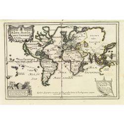
Mappe-Monde ou carte Universelle. . .
Uncommon world map in Mercator's projection, which first appeared in De Fer's Atlas Curieux.Showing California as an island. Engraved by C.Inselin.Shows the explorer's ro...
Place & Date: Paris, 1705

Hemisphaerium Orbis Antiqui cumzonis circulis. . .
A chart showing the eastern hemisphere, including north eastern coast of Australia with, superimposed, climatic zones and planetary details. Surround by most decorative s...
Place & Date: Amsterdam, 1708

Le Nouveau et Curieux Atlas Geographique et historique, ou Le Divertissement des Empereurs, Roys, et Princes. Tant dans la Guerre que dans la Paix. Dédié A Son A.R. Monseigneur le Duc d'Orléans Regent du Roîaume de France.
Charming world atlas with double hemisphere world and the North American map feature the Island of California. In Asia and the Pacific, Australia is incompletely mapped a...
Place & Date: Paris, 1719