Browse Listings in Europe > Eastern Europe

Launa vulgo Laun Bohemiae civitas.
Bird's-eye views of Louny in Bohemia by G. Hoefnagel. The copperplate was made for Braun and Hogenberg's town book. However there the print has been transformed by the en...
Place & Date: The Hague, 1700

Carta geographica generalatus carlostatuensiscum adgacentibus confinis turcicis et venetis...
Fine and rare manuscript map of Croatia and the Dalmatian coast from the early eighteenth century. Oriented to the south the map details the Venetian, Austrian and Turkis...
Place & Date: Venice ?, c. 1700

Danubius Fluvius Europae Maximus, a Fontibus ad Ostia..
Depicts the course of the Danube River, from its sources in the Alps to the Black Sea..Because of the dimensions the map was printed from two copper plates.With two very ...
Place & Date: Amsterdam, 1638
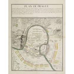
Plan de Prague.
Rare and separately published plan of Prague published by Joan Baptista Nolin with the address à l'enseigne de la Place des Victoires et chez le Sr. Humblot rue St. Jacq...
Place & Date: Paris, ca. 1742
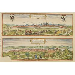
Vienna.. / Buda..
Pair of views on one sheet, the first showing the Austria capital of Vienna with fields, and figures in the foreground.Lower view shows the Hungarian capital of Budapest....
Place & Date: Cologne 1580