Browse Listings in Europe > Eastern Europe

Carta geographica generalatus carlostatuensiscum adgacentibus confinis turcicis et venetis...
Fine and rare manuscript map of Croatia and the Dalmatian coast from the early eighteenth century. Oriented to the south the map details the Venetian, Austrian and Turkis...
Place & Date: Venice ?, c. 1700

Le Cours de l'Elbe et de l'Oder où sont les Electorats de Saxe et de Brandebourg, les Duchés de Mekelbourg et de Pomeranie. . .
A detailed and scarce map showing the rivers Elbe and Oder in Germany and Poland. Dark engraving.This is one sheet of the four sheet wall map by Pierre Du Val entitled: &...
Place & Date: Paris, 1684

Hongarije.
Poster made for Hungarian Tourist association. The uncommon Dutch version of this fine poster to promote Hungary in the 1930's. Arisztid Uher was a graphic designer. He d...
Place & Date: Budapest, KLOSZ / Sohn., ca. 1930
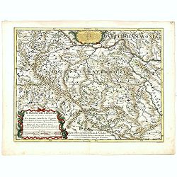
Il regno della Bossima diviso nelle sue provincie principali. . .
Rossi's map of Bosnia, based upon Sanson's map, but with revised Italian nomenclature. From a second edition of his 'Mercurio Geografico...'. The engraver was Cl. Botzot....
Place & Date: Rome, 1689

Vue et description des principales villes de l'Armenie et de la Georgie avec les habillements des femmes du pays, et ceux des prêtres et religieux armeniens. . .Tom: V N° 11 Pag: 28
View and description of the principal Armenian and Georgian cities with illustrations of Armenian women's garments as well as priests' and monks' clothing. The views are ...
Place & Date: Amsterdam, ca 1720