Browse Listings in Europe

A Map of the Environs of Constantinople Drawn from a great number of accurate astronomical & geographical manuscripts and printed documents, by A. Arrowsmith 1801 and 1804.
Arrowsmith’s large and detailed map of the Ottoman Empire and the Black Sea, with Cyprus, Crete and the Greek Islands in the Mediterranean Sea, Albania, Bosnia and Herz...
Place & Date: London, No.10 Soho Square, 4th September 1804

Lutetia Furens. Das ist : Die wütende Statt PARIS.
Rarissime placard dirigé contre la Ligue et le duc de Mayenne. La gravure est signée I.S. (marque inconnue). Ce placard en latin et en allemand est une reprise de l’e...
Place & Date: France ca.. 1594

Angliae, Scotiae, et Hiberniae, sive Britannicar : Insularum descriptio.
A rare and ornate map with inset portraits of James First, Henry Prince of Wales Princess Anne of Denmark.Janssonius acquired the copperplate of van den Keere's 1604 Brit...
Place & Date: Amsterdam, 1621

Hydrograhica descriptio
This very rare chart is important as the first printed sea chart of the Mediterranean coast of Spain, Gibraltar, also depicting the northern coast of Marocco.Willem Bar...
Place & Date: Amsterdam, W.Blaeu, 1612

A Newe mape of Poland Done into English by I.Speede.
A wonderful map of Poland. Incorporated into Speed's 'Prospect Of The Most Famous Parts Of The World.' Includes birds-eye views of Cracow, Dantzick, Posna, Crossen, Sando...
Place & Date: London, 1627

I Europa / Das dritteil der Welt.
Very early wood cut printed map of Europe with South to the top. In the lower-left corner we see Poland, Livonia and parts of England and Ireland in the lower right corne...
Place & Date: Zurich, Christoffel Froschover, 1548,1552-1566

Pascarte van Europa Beginnende vande Canael tot aen Spitbergen, en van Ysland tot aen Nova Zemla . . .
An eye-catching chart of northern Europe with a coastline from northern Russia to the Dutch English Channel in the south. Good detail on Iceland. North to the top.In the ...
Place & Date: Amsterdam, after 1666

Valletta citta nova dimalta.
Early copper engraved map of the towns of Valletta, Borgo, Sanglea di Sto. Michele, and the church of St. Salvator -known as the Three Cities., engraved by Henry Raignaul...
Place & Date: Paris, Michael Soly, 1629

Valletta ou Valete ville Forte, de l'Isle de Malta.
A beautifully engraved and richly detailed birds-eye plan of the harbour and city of Valletta seen from the northwest. In lower part extensive key, identifying 57 feautur...
Place & Date: Amsterdam, 1705

Ducatus Prussiae tam Polono Regiae. . .
This is a rare issue of Frederick de Wit's attractive map of the northern part of Poland, Prussia and the Baltic regions.Very decorative title cartouche, including three ...
Place & Date: Amsterdam, 1698

Group of 21 watercolors of scenes in Iceland, included are vulcanos like Eyjafjallajokull, Öræfajökull, etc.
A group of water colors made during visits of the artist F. de Boungne to Iceland, among them are contemporary artistic impressions of the now world-famous volcano Eyjafj...
Place & Date: Iceland, 1933-1944

Urbium Londini et West-Monasterii nec non Surburbii Southwark Accurata Ichnographia ,., Neuester Grundris der Staedte London und West-Munster, Samt der Vorstadt Southwark ,.,
Detailed plan of London, extending from Grosvenor Square in the west to Mile End to the east, To the right inset views of St, James's Square, and Custom House, elevations...
Place & Date: Nuremberg, 1736

Plan de la ville, cite universite et fauxbourgs de Paris comme il est jourddhuy. . .
Detailed town-plan of Paris.Top left and bottom right and left cartouches decorated with views of the top left, Notre Dame, Palace of Orleans, Sorbonne and Val de Grâce,...
Place & Date: Paris, 1694

Bern in der Schweitz.
Very fine panoramic of Bern. With a numbered key (1-25) of principal buildings in town.
Place & Date: Augsburg, 1740
![Venecie. [Venice] Foliu XLIIII](/uploads/cache/29716-250x250.jpg)
Venecie. [Venice] Foliu XLIIII
A very fine of Venice (192x525mm.) Verso a view of Padua. Schedel's view of Venice is one of the earliest obtainable views of the city. The view is based on the view of ...
Place & Date: Nuremberg, 12 July 1493

Neapolis.
A rare panoramic of Naples with over the whole length of the lower part 3 columns of poems in Latin, Dutch and French.Published by Dancker Danckerts (1634-1666).
Place & Date: Amsterdam, 1660

Europa recens descripta à Guilielmo Blaeuw.
On either side columns depicting the manner of dress in the major countries of Europe, surmounted by nine city views and plans.For European mapmakers their own continent ...
Place & Date: Amsterdam, 1644

Belgii sive Germaniae Inferioris accuratissima tabula.
Very rare and very decorative map with in the right and left borders costumed figures and town plans alternately. In top and bottom border town plans and views.Separate p...
Place & Date: Amsterdam, 1631

Prospetto dell'anfiteatro Flavio . . . / Prospetto di Tutto l'Anfiteatro intiero . . . / Pianta dell' divisa nelli suoi / Spaccato, e veduta interiore dell' Anfiteatro.
Monumental engraving showing the Colloseum in Rome, in its setting, with below a ground-plan and elevation. Engraved and drawn by Alessandro Specchi (1668-1729), an engra...
Place & Date: Rome, 1703

Tractus Danubii, Fluminis in Europa Maximi, A Fontibus, Per Germaniam. . .
This is Blaeu’s first map of the Danube and surrounding regions. The Danube River runs through the map from the top left with its headwaters in the German Black Forest ...
Place & Date: Amsterdam, 1634
![Praga. [Prague]](/uploads/cache/28442-250x250.jpg)
Praga. [Prague]
A rare panoramic of Prague with over the whole length of the lower part 3 columns of poems in Latin, Dutch and French and a numbered key 1-34 to the principal buildings ...
Place & Date: Amsterdam, 1660
Tabula Russiae ex autographo, quod delineandum curavit Foedor filius Tzaris Boris desums... - Domino regionum Iueriae Kartalinie et Groefiniae Tzari etc: dedicata ab Heselo Gerardo M.DC.XIIII
A re-issue, by Willem Blaeu, of Hessel Gerritsz' rare and influential map of Russia. Dutch text on verso, extending west to east from Emden to Aspachan and north to south...
Place & Date: Amsterdam, 1635

Premislia celebris russiae civitas.
RARE only included in part VI of his town book. Bird's-eye of Przemysl in Poland. Frans Hogenberg (1535 Mechelen - Cologne 1590) was a copper engraver and etcher. Georg B...
Place & Date: Cologne, 1618

Nova et recens emendata totius Regni Ungariae una cum adiacentibus et finitimis regionisbus delineatio.
Engraved map by Jan van Deutecum, here the very rare first edition published by Cornelis Nicola in Asterdam in 1596. In very attractive original coloring.A re-issued was ...
Place & Date: Amsterdam, Cornelius Nicol, 1596

EUROP, and the cheife Cities contayned therin described. . .
A good impression from an early edition of this famous and decorative "carte à figures"- map from the first world atlas produced by an Englishman - John Speed'...
Place & Date: London, 1627 - 1676

La Pieuvre Germanique.
Scarce lithographed plate not dated, by Eugène Danzanvilliers, printed by Grandremy in Paris. The plate listed by Adhemar is dated 1874. Eugène Danzanvilliers was a dra...
Place & Date: Paris, 28 Quai de la Rapée, c.1874

Amsterdam Ville du Comté de Hollande et la plus considerable des Provinces Unies. . .
A very decorative and extremely rare town-view of Amsterdam, including a numbered (1-18) key in lower part. Extensive shipping on the IJ. To the left the headquarters of ...
Place & Date: Paris, ca.1750

Tabula Russiae.
One of the most decorative maps of Russia, based on the work of Fedor Borisovich. Visscher's version of Hessel Gerritsz' rare map of Russia. In an inset -130x170mm- a pla...
Place & Date: Amsterdam, 1651

Plan de la ville de Malthe ses Forts, ses Nouvelles Fortiffications. . .
Detailed plan of Valletta. In upper right corner a key (A-Z & 1-32) to the principal places in town. Prepared by N.de Fer and re-issued by Danet.
Place & Date: Paris, 1723

Beschrijvinge vande de zee Cuften va Vlanderen en Picardien. . .
DUTCH TEXT EDITION. A detailed chart of the coast of Flanders and Normandy decorated by a large colorful baroque title cartouche, and the coat of arms of Flanders with a ...
Place & Date: Leiden, Plantijn, 1585

De zee cuften tufschen Dovere en Orfords nesse, daer de Teemse de Vermaerde Rivire van Lonen gelegens is. . .
A detailed chart of the English Channel coastland. Decorated by a colorful title cartouche and scale cartouche, one compass rose, several vessels and sea monsters. A very...
Place & Date: Leiden, Plantijn, 1585

Belchrijuinghe vande zee custen van Engelandt. . .
A rare Dutch text edition of this detailed early chart of the northern coast of England. West to the top. The mileage cartouche has no Latin captures. Decorated by a colo...
Place & Date: Leiden, Plantijn, 1585

Zee caerte vande Sondt tvermaerste van Danemarcke . . .
A detailed chart of the coast of Denmark and its islands, Copenhagen in the center of the chart. West to the top. It is decorated by a title, scale and descriptive cartou...
Place & Date: Leiden, Plantijn, 1585

Piazza e tempio di Santa Maria della Rotonda gia l'Antico Pantheon.
Monumental engraving showing the Pantheon in Rome, in its setting, with below a ground-plan and elevation. Fountain in front, adjacent buildings and carriages and people ...
Place & Date: Rome, 1693

Daniae Regni Typum..
A first state. Very decorative "carte à figures"- map of Denmark with the signature of the engraver Abraham Goos. Printed on heavy paper, in spite of its repai...
Place & Date: Amsterdam, 1629

Nieuw Nederlandtsch Caertboeck. Waer in volkomentlijcker als oyt te voren vertoont werden de XVII. Nederlanden.
Rare first edition of this atlas of the provinces of the Netherlands, Belgium and Luxemburg. Engraved title page, with : "Gedruckt t' Amsterdam by Abraham Goos Plaet...
Place & Date: Amsterdam, 1616

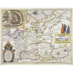
LA RUSSIE NOIRE ou POLONOISE qui Comprend les PROVINCES DE LA RUSSIE NOIRE de VOLHYNIE et de PODOLIE divisées en leurs Palatinats Vulgairement Connües sous le Nom D'VKRAINE ou PAYS DES COSAQUES.
Very rare map of the Ukraine and Poland, prepared by Sanson in 1675 in a third state, published by the heirs of Sanson, in Paris in 1706. The imprint changed to: Par les ...
Place & Date: Paris, 1706

Kaerte en Afbeeldinge vande Geheele Jurisdictie van Stantdarbuyten Gelegen in de Generaliteit onder Marquisaet van Bergen op den Zoom
With a large title cartouche with signature of the maker Adriaan van der Ende, : Kaerte en Afbeeldinge vande Geheele Jurisdictie van Stantdarbuyten Gelegen in de Generali...
Place & Date: Willemstad, 1737

Carte von West=Gallizien welche auf allerhöchsten Befehl Seiner Kaiserlich oesterreichischen und Königlich apostolischen Majestät in den Jahren 1801 bis 1804. . .
Important early map of Western Galicia, as given to Austria by the third Partition of Poland (1795). Due to its long development period, a rare map rich in detail shows t...
Place & Date: Vienna, (1808) after 1811

Europa, ad magnae Europae Gerardi Mercatoris. . .
General map of Europe, as well as Americae Pars, Greenland, Iceland, a Polar landmass, along with the mythical islands of Frisland, Drogeo, and Bradain. A large strapwor...
Place & Date: Amsterdam, 1628