Browse Listings in Asia
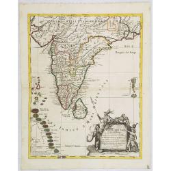
Penisola dell India di là dal Gange et Isole intorno ad essa adiacenti..
Giacomo Rossi's fine late 17th century map of India with Ceylon and Maldives. Issued in Il Mercurio geografico In lower right hand corner a large title cartouche with ded...
Place & Date: Rome, 1683-1688

Het Beloofde Landt Canaan door wandelt . . .
A beautifully engraved map of the ancient land of Canaan which roughly corresponds to present-day Israel. Cherubs hold up a draped cloth of key symbols, also a scale pane...
Place & Date: Amsterdam, 1682

Manuscript map of the Bay of Nagasaki.
An extremely rare manuscript chart in brown ink and wash color on a printed sheet of paper with a system of rhumblines and latitude scales. This chart shows the Bay of Na...
Place & Date: Amsterdam, 1750

Plan de Constantinople, non compris ses faubourgs. Grave d'apres les documents du ministere de la Guerre par E. Olivier.
A very rare lithographic town-plan of Istanbul, Scale 98 yards to one inch., printed in Pera, Istanbul by E. Olivier. The ornate design on the top of the title is a tugh...
Place & Date: Péra, Istanbul, 1851

A view of the town and castle of Macao.
A nice engraving that shows the attack of the English ship "Centurion" on Macau, during which she captured a Portuguese ship that had sailed from Manila. In up...
Place & Date: London, 1746

Nieuwe kaart van 't Koninckryk Bengale. . .
Rare map Bangladesh with the Ganges delta, including Calcutta. Giving great detail with trade routes, European trade settlements, etc. Prepared by Joh. Van Leenen who was...
Place & Date: Amsterdam, 1726

Vue de L'Hotel de Batavie. . .
A so-called optical print of Fatahillah Square in Jakarta, Indonesia, prepared for use in a light-box or an amusing light-show. This richly hand colored print is much per...
Place & Date: Augsburg, 1750

Carte de la Coste d'Arabie.
Uncommon issue of this very nice map of the Arabian peninsula. Depicted is Saudi Arabia, Red Sea and the Persian Gulf.With French text in title cartouche and an additiona...
Place & Date: Amsterdam, 1773
![.Tabula III Asiae. [Caucass and Armenia.]](/uploads/cache/27894-250x250.jpg)
.Tabula III Asiae. [Caucass and Armenia.]
Ptolemaic map of the region south of the Caucasus Mountains and between the Caspian Sea as far south as the headwaters of the Tigris River in the south and the Black Sea,...
Place & Date: Lyons, M. Servetus, 1535
![.Taprobana Ins. Tabula XII Asiae. [Sri Lanka.]](/uploads/cache/27928-250x250.jpg)
.Taprobana Ins. Tabula XII Asiae. [Sri Lanka.]
Ptolemy's mythical island of Taprobana originally became associated with Sri Lanka although it was sometimes confused with Sumatra. Taprobana, as it was called on most ea...
Place & Date: Lyons, M. Servetus, 1535