Browse Listings in America > North America
![[ Indian accessories ].](/uploads/cache/27566-250x250.jpg)
[ Indian accessories ].
Aquatint depicting Indian accessories engraved by Gallina. Plate N°49.From Giulio Ferrario's work Le Costume Ancien et Moderne ou Histoire du gouvernement, de la milice,...
Place & Date: Milan, 1827
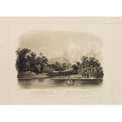
![[ Niagara Falls ]](/uploads/cache/27543-250x250.jpg)
[ Niagara Falls ]
Two aquatints depicting the Horse Shoe Fall (also known as Canadian Falls at the top) and the Fort Schloper Fall (bottom) engraved by Biasolé. From Giulio Ferrario's wor...
Place & Date: Milan, 1827
![[ View of an inn and a horse carriage. ].](/uploads/cache/27552-250x250.jpg)
[ View of an inn and a horse carriage. ].
Aquatint depicting a view of an inn and a horse carriage engraved by Fumagalli. Plate N°44.From Giulio Ferrario's work Le Costume Ancien et Moderne ou Histoire du gouver...
Place & Date: Milan, 1827
![[ William Penn's treaty with the Indians in 1681 ].](/uploads/cache/27555-250x250.jpg)
[ William Penn's treaty with the Indians in 1681 ].
Aquatint depicting William Penn's treaty with the Indians in 1681, after a painting by Benjamin West.William Penn (October 14, 1644 - July 30, 1718) was founder and "...
Place & Date: Milan, 1827
![[ Chief Regolo ].](/uploads/cache/27568-250x250.jpg)
[ Chief Regolo ].
Aquatint depicting chief warriors engraved by G. G. Plate N°58.Cacique from the taíno word for the pre-Columbian tribal chiefs or leaders, of the Taino tribes in the Ba...
Place & Date: Milan, 1827

Major Ridge. A Cherokee Chief.
Head and shoulders portrait of Major Ridge,(1771-1839) wearing a blue jacket, gold or yellow vest, white shirt, and black cravat. A Cherokee Chief, who as a Cherokee lead...
Place & Date: Philadelphia, 1837

Ca-Ta-He-Cas-Sa-Black Hoof. Principal Chief of the Shawanoes.
Half-length portrait of Catahecassa wearing a dark colored jacked, grey vest, white shirt, and grey head scarf.A wonderful hand colored lithograph of Ca-Ta-He-Cas-Sa-Blac...
Place & Date: Philadelphia, 1837

A-Na-Cam-E-Gish-Ca. A Chippeway Chief.
Half-length portrait of Anacamegishca, bare-chested, wearing a blanket and a peace medal. A-Na-Cam-E-Gish-Ca (1785-1862) - was a Chippeway Indian Chief. The Chippewa is o...
Place & Date: Philadelphia, 1837

Forest scene on the Tobihanna Alleghany Mountains.
Original aquatint engraving for Travels in the Interior of North America between 1832-34 . Engraved by L.Weber. The finest work on American Indian life and the American F...
Place & Date: London/Paris/Coblenz, 1839
Waschinga Sahba's Grab.. (Wakonda Creek.)
Original aquatint engraving for Travels in the Interior of North America between 1832-34 . Engraved by Ch. Vogel. The finest work on American Indian life and the American...
Place & Date: London/ Paris/ Coblenz, 1839

20 small lithographed views of Washington DC and Georgetown.
20 small lithographed town-views of Washington DC and Georgetown, cut out from a larger sheet. Showing the East Front of the Capitol, Treasury, Smithsonian Institute, Pre...
Place & Date: Casimir Bohn, Washington, D.C.: 1849

Map of the Great Salt Lake And Adjacent Country in the Territory Of Utah. Surveyed in 1849 and 1850, under the orders of Col. J.J. Abert ...
Map of the Great Salt Lake And Adjacent Country in the Territory Of Utah. Surveyed in 1849 and 1850, under the orders of Col. J.J. Abert .. by Capt. Howard Stansbury .. a...
Place & Date: Ackerman, New York, 1852

Kiepert's Physikalische Wandkarten. VI. Nord-America.
Large folding school wall map of North and Central America printed in chromo-lithography. Published by Dieter Reimer and printed by Leopold Kraatz in Berlin. Three inset...
Place & Date: Berlin, Dieter Reimer, 1864

Plan of the Borough of New Rochelle, Westchester Co. N.Y.
Fine lithographed map of the plan of the Borough of New Rochelle. The map provides the names of specific homeowners, as well as information about the occupations and phys...
Place & Date: New York, 1867
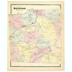
Town of Bedford Westchester Co. NY.
Fine lithographed map of the town of Bedford. The map provides the names of specific homeowners, as well as information about the occupations and physical locations of th...
Place & Date: New York, 1867

Plan of Yonkers Town of Yonkers Westchester Co. N.Y. . . .
Fine lithographed map of Yonkers, New York. The map provides the names of specific homeowners, as well as information about the occupations and physical locations of the ...
Place & Date: New York, 1867

Plan of the Beekmanton Tarryntown and Ivring. Westchester Co. N.Y.
Fine lithographed map of the plan of the Beekmantown, Tarrytown, and Irving, New York. The map provides the names of specific homeowners, as well as information about the...
Place & Date: New York, 1867

New York Ferry Boat. (Bac à vapeur de New York).
A very decorative print showing the New York Ferry Boat "Fulton," published by Currier & Ives. The Ferry boat "Fulton" sails to the right. A singl...
Place & Date: New York, ca. 1875
![[City Of New York and Environs].](/uploads/cache/27530-250x250.jpg)
[City Of New York and Environs].
A very decorative bird's-eye view of Manhattan, Brooklyn, and part of New Jersey. Manhattan Island from the southwest is surrounded by the Hudson, Harlem, East River, and...
Place & Date: New York, 1875

Histoire de la Guerre Civile en Amerique par M. Le Comte de Paris, Ancien Aide de Camp du General Mac Clellan (McClellan). ...
These 30 maps were made by Vorzet to accompany Louis Phillipe d'Orleans' (Comte de Paris) multi volume "Histoire de la Guerre Civile en Amérique". The set incl...
Place & Date: Paris. Michel Levy Freres, 1875

Driving chart of Hartford and vicinity : 15 miles around.
Road map by Albert A. Hyde & Co. of Hartford and vicinity, with the Connecticut River in the center. Published by Albert A. Hyde & Co., in New York and lithograph...
Place & Date: New York / Philadelphia, 1884
![Canada Creek Falls . . [title in French, English, German & Latin] N°32. Pl. 4.](/uploads/cache/26800-250x250.jpg)
Canada Creek Falls . . [title in French, English, German & Latin] N°32. Pl. 4.
A view of the Canada Creek Falls.From 8e Livraison Amérique Septentrionale - Etat de New York. After Jacques Milbert and lithographed by Dupressoir and figures by V. Ada...
Place & Date: Paris, Bove dirigée par Nöel ainé & Cie, 1892
![[Soil map] Virginia-Maryland-West Virginia, Leesburg sheet.](/uploads/cache/23257-250x250.jpg)
[Soil map] Virginia-Maryland-West Virginia, Leesburg sheet.
Early color lithographed soil map by Julius Bien & Co. in New York for Department of Agriculture. Legends at side give detail on soil type, etc. They also include int...
Place & Date: New York, 1903

Guaranty Trust Company of New York. Emprunt national 6%.n Souscrivez.
Very decorative propaganda poster with design by Mark All of Paris for "Guaranty Trust Company of New York", a JPMorgan Chase predecessor in order to promote th...
Place & Date: Paris, 1918

Cunard Cherbourg-New York.
Original vintage Cunard luxury cruise liner travel poster advertising Cunard Europe to all America fastest ocean service in the world. Stunning design featuring two color...
Place & Date: England, ca. 1930

United States At-A-Glance.
A clever device for demonstrating the statistics of each state, the Area, Population, Highest Elevation, Principal River, Capital, railroad Mileage, Date Entered Union, P...
Place & Date: New York & London: International At-A-Glance Chart Co. 1931

French Line CGT Poster.
French Line CGT Poster showing the Normandie cruise ship travelling from Southampton to New York, advertising an express luxury service on both the Ile de France and the ...
Place & Date: England, ca. 1936

San Diego Bay. (Chart 5107)
Nautical chart of San Diego Bay of 1945. Printed in black, yellow and purple the "Seaward limit defensive sea area". The water area within the indicated limits ...
Place & Date: Washington, 1945

Coast to Coast.
A game board that features a map of the U.S. with a built-in spinner. Players travel a circular track around the map visiting landmarks as they go. A fun way to learn geo...
Place & Date: New York, ca. 1950

Sabena (USA - NYC).
Sabena Belgian World Airlines poster showing the skyline of New York in abstract style. Published by Rali Brisart in Belgium.La Sabena, acronym for Societé Anonyme Belg...
Place & Date: Brussels, ca. 1970