Browse Listings in America
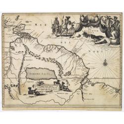
Guiana sive Amazonum Regio.
Map of Guiana and Amazon extending westwards to Trinidad and Margarita Island, dominated by a huge inland sea north of the Amazon.Embellished with decorative title and sc...
Place & Date: Amsterdam, 1673

Yucatan . . . Et Guatimala Conventus Iuridicus.
Very attractive map encompassing the Mexican heartland, the Yucatan peninsula, and the old Spanish Audiencia of Guatemala including Honduras, Nicaragua, Costa Rica and pa...
Place & Date: Amsterdam, 1673

Brasila.
Map of Brazil extending from C. Nasou and Parime Lago to the Mouth of the Rio de la Plata. Oriented with West on top.The cartography of the region is quite primitive. The...
Place & Date: Amsterdam, 1673

Insulae Americanae in Oceanus Septentrionali cum Terris..
General map of the West Indies extending from Virginia to the mouth of the Orinoco, and destined to be copied in various shapes by many other publishers. Title cartouche ...
Place & Date: Amsterdam, 1647

Pas-kaart vande Zee kusten van Venecuela met de Byleggende Eylanden. . .
Rare chart of the coast of Venezuela, including the islands of Curaçao, Bonaire, Aruba, etc.The chart has two insets, one (15x22cm) with a map of Curaçao, one smaller w...
Place & Date: Amsterdam, 1680

Paraguay, Chili, Terre Magellan ?
Map of Paraguay, Chili, and Argentina . By C. F. Delamarche, successor of Robert de Vaugondy, Geographer.
Place & Date: Paris, 1794 -1806

Virginiae Partis Australis, et Floridae Partis Orientalis.
Blaeu based this map on the Mercator-Hondius of 1606. A number of geographical improvements, however were incorporated, although two large fictions lakes accompanied by e...
Place & Date: Amsterdam, 1640

Histoire de la Guerre Civile en Amerique par M. Le Comte de Paris, Ancien Aide de Camp du General Mac Clellan (McClellan). ...
These 30 maps were made by Vorzet to accompany Louis Phillipe d'Orleans' (Comte de Paris) multi volume "Histoire de la Guerre Civile en Amérique". The set incl...
Place & Date: Paris. Michel Levy Freres, 1875

The Traveller's Guide. A Map Of The Roads, Canals And Steam Boat Routes Of The United States ... Designed for the use of Travellers, By H.S. Tanner.
Rare first edition of Tanner's travel map in pocket map form, in it original red leather covers, with the map and no text, as issued. Ristow says the first edition was 18...
Place & Date: Philadelphia, 1825

Carte D'Amerique Divisée en ses Principaux Pays. . .
Rare. Uncommon and decorative wall map of America, prepared by Clouet. With superb decorative borders, 170mm wide at the sides and 150mm at the bottom, containing twenty ...
Place & Date: Paris, Cadiz, 1785