Browse Listings in America
![[ Niagara Falls ]](/uploads/cache/27543-250x250.jpg)
[ Niagara Falls ]
Two aquatints depicting the Horse Shoe Fall (also known as Canadian Falls at the top) and the Fort Schloper Fall (bottom) engraved by Biasolé. From Giulio Ferrario's work...
Date: Milan, 1827
![[ View of an inn and a horse carriage. ].](/uploads/cache/27552-250x250.jpg)
[ View of an inn and a horse carriage. ].
Aquatint depicting a view of an inn and a horse carriage engraved by Fumagalli. Plate N°44.From Giulio Ferrario's work Le Costume Ancien et Moderne ou Histoire du gouvern...
Date: Milan, 1827
![[ William Penn's treaty with the Indians in 1681 ].](/uploads/cache/27555-250x250.jpg)
[ William Penn's treaty with the Indians in 1681 ].
Aquatint depicting William Penn's treaty with the Indians in 1681, after a painting by Benjamin West.William Penn (October 14, 1644 - July 30, 1718) was founder and "...
Date: Milan, 1827
![[ A typical Timucua Indians Village ].](/uploads/cache/27559-250x250.jpg)
[ A typical Timucua Indians Village ].
Aquatint depicting a typical Timucua Indians Village engraved by Fumagalli, after Jacques LeMoyne. The Timucua of northeast Florida (the Saturiwa and Agua Dulce tribes) a...
Date: Milan, 1827
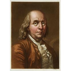
Portrait de Benjamin Franklin.
Portrait de Benjamin Franklin. From Giulio Ferrario's work Le Costume ancien et moderne ou histoire du gouvernement, de la milice, de la religion, des arts, etc. publishe...
Date: Milan, 1827
![[Canadian Indian traditional garments ].](/uploads/cache/27544-250x250.jpg)
[Canadian Indian traditional garments ].
Aquatint depicting Canadian Indian traditional garments engraved by Gallina. Plate N°32.From Giulio Ferrario's work Le Costume Ancien et Moderne ou Histoire du gouverneme...
Date: Milan, 1827
![[Canadian Indians ].](/uploads/cache/27546-250x250.jpg)
[Canadian Indians ].
Aquatint depicting a group of Canadian Indians engraved by Gallina. Plate N° 33 n°1.From Giulio Ferrario's work Le Costume Ancien et Moderne ou Histoire du gouvernement, ...
Date: Milan, 1827
![[View of the Potomac River from Mount Vernon ].](/uploads/cache/27550-250x250.jpg)
[View of the Potomac River from Mount Vernon ].
Aquatint depicting a view of the Potomac River from Mount Vernon engraved by Fumagalli. Plate N°46.From Giulio Ferrario's work Le Costume Ancien et Moderne ou Histoire du...
Date: Milan, 1827
![[Florida Indian cooking ].](/uploads/cache/27561-250x250.jpg)
[Florida Indian cooking ].
Aquatint depicting Florida Indian cooking engraved by Fumagalli. Plate N°54.From Giulio Ferrario's work Le Costume Ancien et Moderne ou Histoire du gouvernement, de la mi...
Date: Milan, 1827
![[Slave labor on an indigo plantation ].](/uploads/cache/27564-250x250.jpg)
[Slave labor on an indigo plantation ].
Aquatint depicting slave labor on an indigo plantation engraved by Fumagalli. Plate N°51.From Giulio Ferrario's work Le Costume Ancien et Moderne ou Histoire du gouvernem...
Date: Milan, 1827
![[Slave labor on a Tobacco plantation ].](/uploads/cache/27565-250x250.jpg)
[Slave labor on a Tobacco plantation ].
Aquatint depicting slave labor on an tobacco plantation engraved by Biasioli. Plate N°50.From Giulio Ferrario's work Le Costume Ancien et Moderne ou Histoire du gouvernem...
Date: Milan, 1827
![[ Indian accessories ].](/uploads/cache/27566-250x250.jpg)
[ Indian accessories ].
Aquatint depicting Indian accessories engraved by Gallina. Plate N°49.From Giulio Ferrario's work Le Costume Ancien et Moderne ou Histoire du gouvernement, de la milice, ...
Date: Milan, 1827
![[ Chief Regolo ].](/uploads/cache/27567-250x250.jpg)
[ Chief Regolo ].
Aquatint depicts Chief Regolo (also called Cacique) accompanied by his women, who are engraved by Gallina. Plate N°57.Cacique from the taíno word for the pre-Columbian tr...
Date: Milan, 1827
![[ Chief Regolo ].](/uploads/cache/27568-250x250.jpg)
[ Chief Regolo ].
Aquatint depicting chief warriors engraved by G. G. Plate N°58.Cacique from the taíno word for the pre-Columbian tribal chiefs or leaders of the Taino tribes in the Baham...
Date: Milan, 1827
![[ Cofre de Perote ].](/uploads/cache/27569-250x250.jpg)
[ Cofre de Perote ].
Aquatint depicting the Cofre de Perote engraved by Fumagalli. Plate N°59.Cofre de Perote, mean something like 'Mountain of the Lord of Four Places'. This extinct volcano ...
Date: Milan, 1827
![[ Regla columnar basalt quarry ].](/uploads/cache/27570-250x250.jpg)
[ Regla columnar basalt quarry ].
Aquatint depicting columnar basalt quarry engraved by Fumagalli. Plate N°60.This common extrusive volcanic rock is used for highway construction, railroad ballast, and ti...
Date: Milan, 1827
![[ Jorullo Volcano ].](/uploads/cache/27571-250x250.jpg)
[ Jorullo Volcano ].
Aquatint depicting the Jorullo Volcano engraved by Fumagalli. Plate N°61.El Jorullo is a cinder cone volcano in Michoacán, central Mexico in an area known as the Michoacá...
Date: Milan, 1827
![[ Portraits of Motezuma II and Cortes ].](/uploads/cache/27573-250x250.jpg)
[ Portraits of Motezuma II and Cortes ].
Aquatint depicting two portraits of Motezuma II and Cortes engraved by Gallina. Plate N°63.Montezuma II was trained as a priest and rose to become leader of the Aztecs in...
Date: Milan, 1827
![[ Montezuma II As Represented in an Anonymous Codex in The Vatican ].](/uploads/cache/27574-250x250.jpg)
[ Montezuma II As Represented in an Anonymous Codex in The Vatican ].
Aquatint depicting Motezuma II represented in the Vatican's anonymous codex engraved by DKB. Plate N°64.The Codex Vaticanus, so called because it is the most famous manus...
Date: Milan, 1827
![[ Mexican weapons ].](/uploads/cache/27575-250x250.jpg)
[ Mexican weapons ].
Aquatint depicting Mexican weapons engraved by DKB. Plate N°65.From Giulio Ferrario's work Le Costume Ancien et Moderne ou Histoire du gouvernement, de la milice, de la r...
Date: Milan, 1827
![[ Mexican weapons ].](/uploads/cache/27576-250x250.jpg)
[ Mexican weapons ].
Aquatint depicting an Oaxaca monument representing a warrior engraved by Bonatti. Plate N°66.Oaxaca is the historic home of the Zapotec and Mixtec peoples, and contains m...
Date: Milan, 1827
![[ Aztec low relief representing ancient warriors ].](/uploads/cache/27577-250x250.jpg)
[ Aztec low relief representing ancient warriors ].
Aquatint depicting an Oaxaca monument representing a warrior engraved by Bonatti. Plate N°67.From Giulio Ferrario's work Le Costume Ancien et Moderne ou Histoire du gouve...
Date: Milan, 1827
![[ Hieroglyph representing the Cihuacohuat Goddess ].](/uploads/cache/27578-250x250.jpg)
[ Hieroglyph representing the Cihuacohuat Goddess ].
Aquatint depicting a hieroglyph representing the Cihuacohuat Goddess engraved by DKB. Plate N°68.From Giulio Ferrario's work Le Costume Ancien et Moderne ou Histoire du g...
Date: Milan, 1827
![[ Azrec Idols ].](/uploads/cache/27579-250x250.jpg)
[ Azrec Idols ].
Aquatint depicting Aztec idols engraved by Gallina. Plate N°698.From Giulio Ferrario's work Le Costume Ancien et Moderne ou Histoire du gouvernement, de la milice, de la ...
Date: Milan, 1827
![[Human sacrifice.]](/uploads/cache/27582-250x250.jpg)
[Human sacrifice.]
Aquatint depicting a human sacrifice engraved by Gallina. Plate N°72.From Giulio Ferrario's work Le Costume Ancien et Moderne ou Histoire du gouvernement, de la milice, d...
Date: Milan, 1827
![[ Gladiators ].](/uploads/cache/27583-250x250.jpg)
[ Gladiators ].
Aquatint depicting gladiators in combat engraved by Gallina. Plate N°73.From Giulio Ferrario's work Le Costume Ancien et Moderne ou Histoire du gouvernement, de la milice...
Date: Milan, 1827
![[ Local Mexican Indian game, the Voladores de Papantla ].](/uploads/cache/27587-250x250.jpg)
[ Local Mexican Indian game, the Voladores de Papantla ].
Aquatint depicting local game engraved by Fumagalli. Plate N°77.The Aztecs also had spectacular dances such as the Voladores de Papantla ,the Sun Dance, in which the danc...
Date: Milan, 1827
![[ Acrobatic games ].](/uploads/cache/27589-250x250.jpg)
[ Acrobatic games ].
Aquatint depicting acrobatic games engraved by Gallina. Plate N°78.From Giulio Ferrario's work Le Costume Ancien et Moderne ou Histoire du gouvernement, de la milice, de ...
Date: Milan, 1827
![[ Bread making ].](/uploads/cache/27591-250x250.jpg)
[ Bread making ].
Aquatint depicting a family making bread engraved by Gallina. Plate N°82.From Giulio Ferrario's work Le Costume Ancien et Moderne ou Histoire du gouvernement, de la milic...
Date: Milan, 1827
![[ Mexican traditional garments ].](/uploads/cache/27592-250x250.jpg)
[ Mexican traditional garments ].
Aquatint depicting Mexican traditional garments engraved by Gallina. Plate N°83.From Giulio Ferrario's work Le Costume Ancien et Moderne ou Histoire du gouvernement, de l...
Date: Milan, 1827
![[ Hieroglyph Christian calendar written in an Aztec style ].](/uploads/cache/27593-250x250.jpg)
[ Hieroglyph Christian calendar written in an Aztec style ].
Aquatint depicting Hieroglyph Christian calendar written in an Aztec style engraved by BonattiB. Plate N°84.From Giulio Ferrario's work Le Costume Ancien et Moderne ou Hi...
Date: Milan, 1827
![[ Mechoacan Indians traditional garments ].](/uploads/cache/27594-250x250.jpg)
[ Mechoacan Indians traditional garments ].
Aquatint depicting Mechoacan Indians traditional garments engraved by Gallina. Plate N°85.From Giulio Ferrario's work Le Costume Ancien et Moderne ou Histoire du gouverne...
Date: Milan, 1827
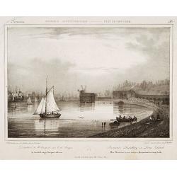
Pierpont's distillery on Long Island.
Milbert's topographical prints are an eyewitness record of life in America in the early 19th centuryDecorative print after Jacques Milbert, and lithographed by Sabatier a...
Date: Paris, 1829
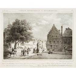
View in Albany-House of the first Dutch Governors.
Decorative print after Jacques Milbert, and lithographed by Tierpenne and the figures by Victor Adam.From Amérique Septentrionale. Printed by de Bove and Noöl ainé &C...
Date: Paris, 1829

Carte des Iles Hawaii.
A lovely small map of the complete chain of Pacific islands known today as the Hawaiian islands, from Dumont d'Urville's atlas "Voyage pittoresque autour du Monde.&q...
Date: Paris, 1834

A-Na-Cam-E-Gish-Ca. A Chippeway Chief.
Half-length portrait of Anacamegishca, bare-chested, wearing a blanket and a peace medal. A-Na-Cam-E-Gish-Ca (1785-1862) - was a Chippewa (Ojibwe) Native American chief. ...
Date: Philadelphia, 1837

Ca-Ta-He-Cas-Sa-Black Hoof. Principal Chief of the Shawanoes.
Half-length portrait of Catahecassa wearing a dark colored jacked, grey vest, white shirt, and grey head scarf. A wonderful hand colored lithograph of Ca-Ta-He-Cas-Sa-Bla...
Date: Philadelphia, 1837

Major Ridge. A Cherokee Chief.
Head and shoulders portrait of Major Ridge,(1771-1839) wearing a blue jacket, gold or yellow vest, white shirt, and black cravat. A Cherokee Chief, who as a Cherokee lead...
Date: Philadelphia, 1837

Forest scene on the Tobihanna Alleghany Mountains.
Original aquatint engraving for Travels in the Interior of North America between 1832-34 . Engraved by L.Weber. The finest work on American Indian life and the American F...
Date: London/Paris/Coblenz, 1839
Waschinga Sahba's Grab.. (Wakonda Creek.)
Original aquatint engraving for Travels in the Interior of North America between 1832-34 . Engraved by Ch. Vogel. The finest work on American Indian life and the American...
Date: London/ Paris/ Coblenz, 1839
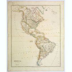
America.
A beautiful, large-scale map of the Americas. Alaska is named as 'Russian America', Texas is still a part of Mexico, yet to become a republic (1836), before finally becom...
Date: London, 1839
Selling price: ????
Please login to see price!
Sold in 2025

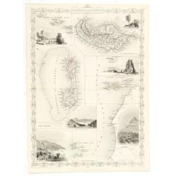
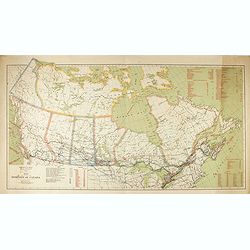
Upper Canada &c.
A beautiful, large scale map of Upper Canada, and portions of the American states of New York, Ohio, and Pennsylvania. The province of 'Upper' Canada was created by the B...
Date: London, 1839
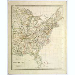
United States.
A lovely large map of the Untied States, as it was at the time of publication. Each state shown in a different outline color. Nothing is shown west of Louisiana, Arkansas...
Date: London, 1839
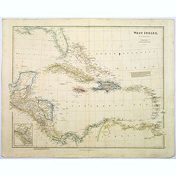
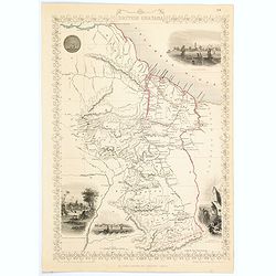
West Indies.
A fine, detailed steel engraved map comprising Florida, Bahamas, Cuba, Haiti, Jamaica, the Windward, and the Leeward Islands, the northern Columbian coastline, Panama, Gu...
Date: London, 1839
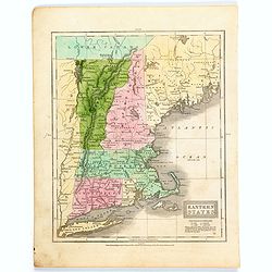
Eastern States.
A map of the eastern US seaboard from Long Island north to Lower Canada, comprising the states of Connecticut, Rhode Island, Massachusetts, New Hampshire, Maine, Vermont ...
Date: Connecticut, 1839

La parte orientale dell' antico.. messico con la Florida..
A splendid two-sheet map of Mexico, including California, Arizona, New Mexico, part of Texas, Baja California and Mexico (west part) and of the Southeast Part of the US, ...
Date: Rome, Calcography, 1797-before 1839

Entrée des forêts de la rivière Sedger. . .
Exquisite contemporary colored lithograph of Sedger's river in the Chili, with as seen by Dumont D'Urville's, with Indians. Drawn by Louis Le Breton, lithographed by Bich...
Date: Paris, 1846

Rivage du port Saint-Nicolas.
Exquisite contemporary colored lithograph of Port Saint-Nicolmas Bay in most southern part of South America, with Dumont D'Urville's officers making landfall. Drawn by E....
Date: Paris, 1846

20 small lithographed views of Washington DC and Georgetown.
20 small lithographed town-views of Washington DC and Georgetown, cut out from a larger sheet. Showing the East Front of the Capitol, Treasury, Smithsonian Institute, Pre...
Date: Casimir Bohn, Washington, D.C.: 1849
![Posesiones de America : Isla de Cuba. [together with] Isla de Cuba. . .](/uploads/cache/23458-250x250.jpg)
Posesiones de America : Isla de Cuba. [together with] Isla de Cuba. . .
Wall size sea chart and map of land areas showing all of Cuba, part of Florida Keys plus San Adios and Salvador Grande in the Bahamas.Minute topographical, political, and...
Date: Madrid, 1853 / 1851
Islands in the Atlantic.
Decorative steel engraved map of Islands showing the Azores, Madeira, Bermuda, the Canaries and the Cape Verdes. Interlocking border design. Taken from "The illustra...
Date: London, ca. 1851

Map of the Great Salt Lake And Adjacent Country in the Territory Of Utah. Surveyed in 1849 and 1850, under the orders of Col. J.J. Abert ...
Map of the Great Salt Lake And Adjacent Country in the Territory Of Utah. Surveyed in 1849 and 1850, under the orders of Col. J.J. Abert .. by Capt. Howard Stansbury .. a...
Date: Ackerman, New York, 1852
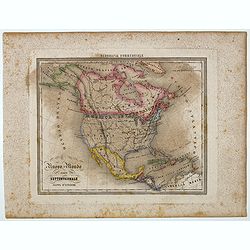
Nuovo Mondo parte Settentrionale.
Uncommon map of North America prepared by Francesco Costantino Marmocchi. Above the map "Geografia Commerciale". From "Il Globo Atlante di carte Geografich...
Date: Genova, Paolo Rivara fu Giacomo, 1858
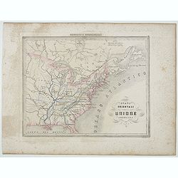
Stati Orientali della Unione Americana.
Uncommon map of Northeastern America prepared by Francesco Costantino Marmocchi. Above the map "Geografia Commerciale". From "Il Globo Atlante di carte Geo...
Date: Genova, Paolo Rivara fu Giacomo, 1858
British Guayana.
A decorative steel engraved map of British Guyana. The last Tallis map of the region, published circa 1858 by The London Printing and Publishing Company (the partnership ...
Date: London, 1858
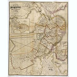
Plan Of Boston Comprising a Part of Charlestown and Cambridge. Published by George G. Smith, Engraver, Washington Street Boston 1855..
Important and detailed plan of Boston, with insets :"Plan Of East Boston from actual Survey by R.H. Eddy" and "Plan Of South Boston From a Drawing by S.P. ...
Date: Boston, ca. 1859

Kiepert's Physikalische Wandkarten. VI. Nord-America.
Large folding school wall map of North and Central America printed in chromo-lithography. Published by Dieter Reimer and printed by Leopold Kraatz in Berlin. Three inset...
Date: Berlin, Dieter Reimer, 1864
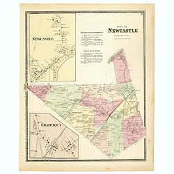
Town of New Castle. Westchester Co. NY.
Fine lithographed map of the town of New Castle. The map provides the names of specific homeowners, as well as information about the occupations and physical locations of...
Date: New York, 1867

Plan of Yonkers Town of Yonkers Westchester Co. N.Y. . . .
Fine lithographed map of Yonkers, New York. The map provides the names of specific homeowners, as well as information about the occupations and physical locations of the ...
Date: New York, 1867

Plan of the Borough of New Rochelle, Westchester Co. N.Y.
Fine lithographed map of the plan of the Borough of New Rochelle. The map provides the names of specific homeowners, as well as information about the occupations and phys...
Date: New York, 1867

Plan of the Beekmanton Tarryntown and Ivring. Westchester Co. N.Y.
Fine lithographed map of the plan of the Beekmantown, Tarrytown, and Irving, New York. The map provides the names of specific homeowners, as well as information about the...
Date: New York, 1867

North Pacific.
Huge three sheet so-called Blue-back sailing chart of the Northern Pacific including China, Korea (with Matu Is. and Liancourt), Japan, Philippines, Kamchatka, Hawaii, Al...
Date: London, 1868
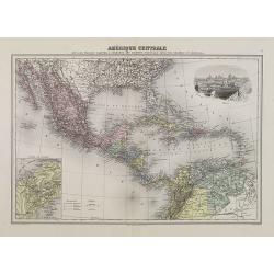
Amérique Centrale.
Decorative map of Central America from Géographie Universelle, Atlas Migeon. With an inset map of the Isthmus of Panama lower left corner and a panoramic view of Mexico C...
Date: Paris, 1874

Histoire de la Guerre Civile en Amerique par M. Le Comte de Paris, Ancien Aide de Camp du General Mac Clellan (McClellan). ...
The maps are chromolithographs and offer a fascinating view of the Civil War battlegrounds. Vorzet made these 30 maps to accompany Louis Phillipe d'Orleans' (Comte de ...
Date: Paris. Michel Levy Freres, 1875

New York Ferry Boat. (Bac à vapeur de New York).
A very decorative print showing the New York Ferry Boat "Fulton," published by Currier & Ives. The Ferry boat "Fulton" sails to the right. A singl...
Date: New York, ca. 1875

Mapa geogra´fico de la mayor parte de la Ame´rica Meridional que contiene los paises por donde debe trazarse la li´nia divisoria que divida los dominios de Espan~a y Portugal. . .
Rare first edition of the map drawn by Francisco Requena (1743-1824) after his expedition to the Amazon in order to delineate the boundary between the Spanish and Portugu...
Date: Bourquin, F. Philadelphia, ca. 1876

Région arctique.
1877 VIVIEN DE SAINT MARTIN, L. - Map of the North Pole, together with the often missing overlay with the Arctic expedition of Captain Nares.
Date: Paris, Hachette, 1877

Dutton Map of the Grand Canyon, Arizona (in 4 joined sheets)
An important 1882 map of the Grand Canyon, Arizona, published in "Atlas To Accompany The Monograph On The Tertiary History Of The Grand Canon District By Capt. Clare...
Date: Julius Bien and Co., 1882

Driving chart of Hartford and vicinity : 15 miles around.
Road map by Albert A. Hyde & Co. of Hartford and vicinity, with the Connecticut River in the center. Published by Albert A. Hyde & Co., in New York and lithograph...
Date: New York / Philadelphia, 1884
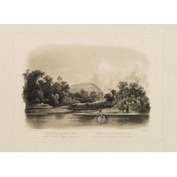
![Canada Creek Falls . . [title in French, English, German & Latin] N°32. Pl. 4.](/uploads/cache/26800-250x250.jpg)
Canada Creek Falls . . [title in French, English, German & Latin] N°32. Pl. 4.
A view of the Canada Creek Falls.From 8e Livraison Amérique Septentrionale - Etat de New York. After Jacques Milbert and lithographed by Dupressoir and figures by V. Adam...
Date: Paris, Bove dirigée par Nöel ainé & Cie, 1892
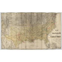
Map showing the cotton growing belt in the United States Prepared for and copyrighted by Geo. H.Mc.Fadden & Bro., cotton merchands based in Phiiladelphia, USA 1892.
The cotton-growing Belts in the Southern States for 1892 A rare map showing the cotton-growing Belts in the Southern States for 1892. Prepared for and copyrighted by G...
Date: Philadelphia, 1892
![[Soil map] Virginia-Maryland-West Virginia, Leesburg sheet.](/uploads/cache/23257-250x250.jpg)
[Soil map] Virginia-Maryland-West Virginia, Leesburg sheet.
Early color lithographed soil map by Julius Bien & Co. in New York for Department of Agriculture. Legends at side give detail on soil type, etc. They also include int...
Date: New York, 1903
![[United States map with Ottoman script.]](/uploads/cache/44314-250x250.jpg)
[United States map with Ottoman script.]
Postcard-size map in Ottoman script showing the United States, prepared by Mehmet EŞREF in a small atlas: عمومولاياةىشهانيىحاوىكوچكاطلاس [Umum-i vilayat-ı Şahaneyi havi...
Date: Istanbul, 1325 or 1909
![[ North and South America with telegraph cables, with Ottoman script]](/uploads/cache/44330-250x250.jpg)
[ North and South America with telegraph cables, with Ottoman script]
Postcard size map showing North and South America with telegraph cables. The map is in Ottoman Arabic-script prepared by Mehmet EŞREF in a small atlas : عمومولاياةىشهاني...
Date: Istanbul, 1325 or 1909

Nuevo plano de la ciudad de Buenos Aires y parte del partido de avellaneda . . .
A rare detailed city plan of Buenos Aires prepared in 1912 by Ernesto Escalante. The plan depicts the city from the Partido de Avellaneda and the Villa Riachuelo to the R...
Date: Buenos Aires, 1912

Guaranty Trust Company of New York. Emprunt national 6%.n Souscrivez.
Very decorative propaganda poster with design by Mark All of Paris for "Guaranty Trust Company of New York", a JPMorgan Chase predecessor in order to promote th...
Date: Paris, 1918
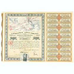
Accion de 10 pesos. No. 110,931 (Share certificate)
Beautifully engraved certificate from the "Compania Azucarera de Paraiso Novillero S.A. Republica Mexicana", share certificate No.110,931 for one share, in a $ ...
Date: Paris, 1924

Cunard to Canada.
Poster by Charles Eddowes Turner for Cunard lines. The poster shows The NEW SYLVANIA, one of the four new 22,000 - ton Cunarders which are the largest ever built for serv...
Date: England, ca. 1930

Cunard Cherbourg-New York.
Original vintage Cunard luxury cruise liner travel poster advertising Cunard Europe to all America fastest ocean service in the world. Stunning design featuring two color...
Date: England, ca. 1930
