Wish List

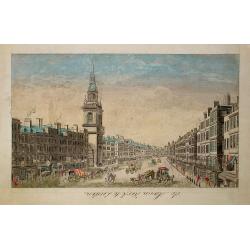
Vue de Boston vers le Cale du Port.
A view of the port of Boston, the center of New England shipping in the colonial period. The closing of the port after the Boston Tea Party led to the calling of the Firs...
Place & Date: Augsburg 1762
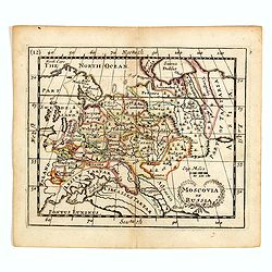
Moscovia or Russia
A rare late seventeenth-century English map of Russia and the Crimea and southern Ukraine, with the northern coast of the Black Sea and its shores. A scarce little map ut...
- $300 / ≈ €281
Place & Date: London, 1685
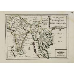
Les Vrays Indes dits Grands Indes ou Indes Orientales Par N. de Fer. Geographe de Sa Majeste Catoliques et de Monseigneur le Dauphin.
Detailed map on India, Thailand, the Malay Peninsular and the south coast of China up to Macao. The map was engraved by C. Inselin.
- $500 / ≈ €468
Place & Date: Paris, 1703

Irlandiae Regnum.
A very nice map from Ireland.Mercator was born in Rupelmonde in Flanders and studied in Louvain under Gemma Frisius, Dutch writer, astronomer and mathematician. The excel...
Place & Date: Amsterdam, 1630

L'Amerique Septentrionale.
Very rare map, from "Metaphaste Barbao, Descriptio Indiae Occidentalis et America Nova" published by Henrico Verdussen.The map is a copy of Guillaume de L'Isle'...
- $1250 / ≈ €1170
Place & Date: Antwerp, 1702

Terra Promissions.
A beautifully executed and very rare map of the Promised Land, divided into the 12 Tribes. The shore line runs in north-southwesterly direction from Sidon as far as Pelus...
Place & Date: Paris, c.1655
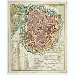
Urbis Augustae Vindobonae.
Engraved city map of Augsburg by Christoph Weigel. Plan of the city with fortifications, left Leopoldstadt, below an extensive key with description. From Bequemer Schul- ...
Place & Date: Nuremberg, 1718
Selling price: $200
Sold in 2023
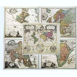
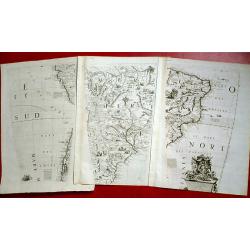
(Set of world and continents) Planiglobii Terrestris cum Utroq Hemisphaerio ..
Five maps; world and four continents.Planiglobii Terrestris cum Utroq Hemisphaerio .. - A large decorative double hemisphere world map including four polar spheres, each ...
Place & Date: Nuremberg, 1746

(Two Lithographs) Regne Animal de Mr. le Baron Cuvier. Dispose en Tableaux Arachnides Par J. ACHILLE COMTE.
Two large scale lithograph's from the 'Le Règne Animal' - The Animal Kingdom. By Jean Léopold Nicolas Frédéric Cuvier - Baron Cuvier and assisted by J. Achille Comte...
Place & Date: Paris, 1825
A set of 3 Coronelli Globe gores,showing Brazil, Argentina, Chile and Peru.
These globe segments were published in 1696 as part of the atlas entitled "Libri dei Globi". This atlas contained the sheets from which his two globes (one of t...
Place & Date: Venice, 1696
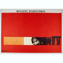
Ministry of health warned . . .
Uncommon Soviet propaganda poster against tobacco consumption.Read more about the Soviet propaganda poster. [+]
Place & Date: Moscow, 1988
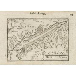
Mare Rubrum / Mer Rouge.
Wonderful miniature map includes the Red Sea, Yemen, and the east coast of the Arabian peninsula. One of the early maps to focus on this area. The title cartouche on the ...
- $300 / ≈ €281
Place & Date: Amsterdam / Frankfurt, 1609
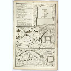
Villes de la province de Petche-li.
Five town plans : Peking (with forbidden town), Yung-ping-fou, Long-men-hien, Yuen-keou/Tching-sse-yu/Si-yang-keou/Hoang-tou-in, Tchin-ting-fou. From "Description ge...
- $150 / ≈ €140
Place & Date: Paris, P.G. Le Mercier, 1735
![[Printed on silk] Nova Totius Americae Sive Novi Orbis Tabula, Auct. Hugo Allardt.](/uploads/cache/48420-250x250.jpg)
[Printed on silk] Nova Totius Americae Sive Novi Orbis Tabula, Auct. Hugo Allardt.
Hugo Allard’s ca. 1661 map of the Americas, showing California as an island printed on silk. This separately issued map printed on paper is quite rare on the market. T...
Place & Date: Amsterdam, 1661
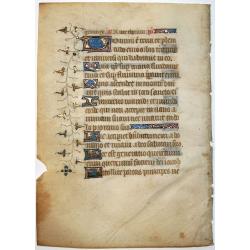
Leaf on vellum from a manuscript Book of Hours.
Nice vellum leaf from a French Book of Hours, written in the style of the scriptoriums of Rouen. Written in brown ink with red rubrics, line fillers, initials and decorat...
Place & Date: France ca.1460
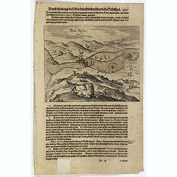
Description de nouveau pasage vers le zud.... together with an untitled map of Port Desire (today's Puerto Deseado, Argentina)
On verso a map of Tierra del Fuogo (167 x 201mm.) and on recto a scarce print (145x210mm.) on a German text sheet showing a map of Port Desire (today’s Puerto Deseado, ...
Place & Date: Frankfurt, M.Merian, 1631
Selling price: $150
Sold in 2023

(Art déco gouache)
Outstanding "art deco" gouache (unsigned) from the workshop of "Robert Pichon. Ateliers de Dessin et Lithographie – 10, rue Rochechouart – Paris. The g...
Place & Date: Paris, ca. 1930
![[ A Teocalli in Mexico - Aztec Temple ].](/uploads/cache/27580-250x250.jpg)
[ A Teocalli in Mexico - Aztec Temple ].
Aquatint depicting a Aztec Temple engraved by Fumagalli. From Giulio Ferrario's work Le Costume Ancien et Moderne ou Histoire du gouvernement, de la milice, de la religio...
- $150 / ≈ €140
Place & Date: Milan, 1827
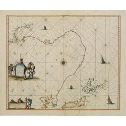
Noordoost Cust van Asia van Japan tot Nova Zemla.
An eye-catching chart of Hokkaido and the Islands to the North of Japan. Ships navigate the seas around the Siberian, Chinese and Japanese coast extending as far west as ...
Place & Date: Amsterdam 1666
Carte topographique DE L'ISLE MINORQUE, Dédiée et présentée au Roy ..
Very rare map depicting the island of Minorca. The upper left is decorated with a stunning title cartouche, engraved by Choffard.The French text on the left side contains...
Place & Date: Paris, 1756
![[Attack of Dutch fleet commanded by Pieter van der Does of Gran Canaria in 1599].](/uploads/cache/40179-250x250.jpg)
[Attack of Dutch fleet commanded by Pieter van der Does of Gran Canaria in 1599].
Attack of Dutch fleet commanded by Pieter van der Does of Gran Canaria in 1599. Scarce print (150x177mm.) on a German text sheet taken from a first edition of Johann Ludw...
- $180 / ≈ €168
Place & Date: Frankfurt, M.Merian, 1633

AFFAIRES D'ORIENT Départ des Grenadiers de la Garde Anglaise, à bord du Steamer transatlantique l'Orenoco. . .
Beautiful lithography of the British steamboat "l'Orenoco" departure from Southampton in May 1854, with soldiers leaving for the Crimean War. After a design Lou...
Place & Date: Paris, Lemercier, c.1860

Sur la route triomphante d'Arles aux Baux - A Fontvieille visitez le moulin et le musée Alphonse Daudet.
Advertising poster for PLM created by the French artist Léo Lelée . " Sur la route triomphante d'Arles aux Baux " . " A Fontvieille visitez le moulin et ...
- $900 / ≈ €842
Place & Date: Paris, G. de la Vasselais, 1935

Diverses cartes et tables pour la géographie ancienne, pour la chronologie et pour les itinéraires et voyages modernes.
Edition without date. Variant edition containing three parts : "Cartes géographiques dressées pour bien entendre les Historiens… / La Chronologie en plusieurs Ta...
Place & Date: Paris, l'Auteur, no date ca.1669
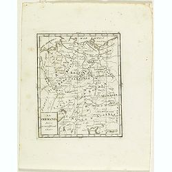
La Germania divisa ne' suoi differenti stati
Rare map of Germany, from "Atlante Novissimo ad uso Dei Giovani Studiosi Contenuto In Carte XXVII.", published by Giovanni Zempel in Rome, ca. 1780.The map is b...
- $25 / ≈ €23
Place & Date: Rome, 1780
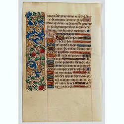
Manuscript leaf, on vellum from a book of hours.
The flesh side of the vellum has 4 large 1-line initial illuminated initials in blue and red with white heightening, on a very heavily burnished gold ground. 1 side illum...
- $350 / ≈ €328
Place & Date: Paris, 1450

De Texel Stroom .. vant Marsdiep./ Caarte van De Mase...
Two decorative charts on one sheet, one depicting Texel and the entrance of the Zuider Zee with an inset showing the north coast of West-Friesland, the other depicting th...
- $750 / ≈ €702
Place & Date: Amsterdam, 1660
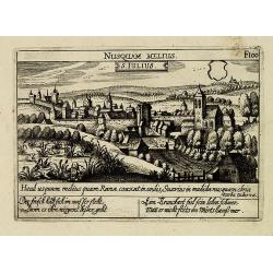
S. Iulius.
A very nice view of the town. In the foreground, a bridge with several frogs are depicted with a verse in two languages underneath the picture.The poet and topographer fr...
- $80 / ≈ €75
Place & Date: Frankfurt, 1623-1678
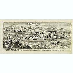
Canisia.
Magnificent bird's eye- of Nagykanizas. Etched by Gaspar Bouttats (1640-1695).The Antwerp based publisher Jacques Peeters published ca. 1690 a series of prints related to...
- $90 / ≈ €84
Place & Date: Antwerp, c.1690

Carte de la Mer Rouge, depuis Moka jusqu's Gedda. . . .
Chart of the Red Sea. With 3 inset maps of Shake Omare, Goofs and Gedan. D'Après De Mannevillette (1707-1780) was one of France's first hydrographers. When the first edi...
Place & Date: Paris, 1753
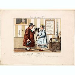
De Maria kerk te Leiden.
In the eighteenth and nineteenth centuries, there were many popular speciality establishments in Paris, Augsburg and London that produced optical viewing devices and spec...
- $200 / ≈ €187
Place & Date: Paris, 1760
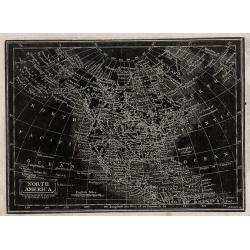
(2 maps) North America / South America.
Two distinctive woodblock engraved maps of North & South America where the printing is reversed - white on black. The map was published in London in 1832 in William P...
Place & Date: London, 1832
![[ Bread making ].](/uploads/cache/27591-250x250.jpg)
[ Bread making ].
Aquatint depicting a family making bread engraved by Gallina. Plate N°82.From Giulio Ferrario's work Le Costume Ancien et Moderne ou Histoire du gouvernement, de la mili...
Place & Date: Milan, 1827
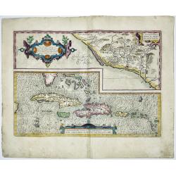
CULIACANAE,A MERICAE REGIO NIS, DESCRIPTIO - Hispaniolae, Cubae, Aliarumique Insularum Circumiacientium Delineatio
CULIACANAE, A MERICAE REGIO NIS, DESCRIPTIO - Hispaniolae, Cubae, Aliarumique Insularum Circumiacientium Delineatio.Antique map of the Caribbean. Two maps on one sheet: ...
Place & Date: Antwerp, 1603-1612
Selling price: $400
Sold in 2023
![Etats-Unis de L'Amerique Septentrionale. [Two sheets in manuscript ]](/uploads/cache/03972-250x250.jpg)
Etats-Unis de L'Amerique Septentrionale. [Two sheets in manuscript ]
Two sheets giving an detailed information in French, about population in the year 1810, principal cities, products of industry and commerce, financial situation for the y...
- $2000 / ≈ €1871
Place & Date: France, ca. 1819
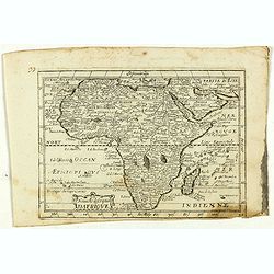
Nouvelle description d'Afrique.
Rare map of Africa published by Jollain in 1667. Published in "Trésor Des Cartes Geographiques Des Principaux Estats de Lunivers".This atlas is based upon Bois...
- $250 / ≈ €234
Place & Date: Paris, 1667
![[Lot of 15 maps / prints of the British Isles + Irland]. Le Royaume d'Angleterre distingué en see Provinces.](/uploads/cache/7148-(1)-250x250.jpg)
[Lot of 15 maps / prints of the British Isles + Irland]. Le Royaume d'Angleterre distingué en see Provinces.
A-H Jaillot's large and attractive map of England. Embellished with an elaborate title cartouche. Newly engraved for the counterfeited edition of the ' Atlas Nouvea...
Place & Date: Paris 1696
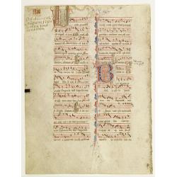
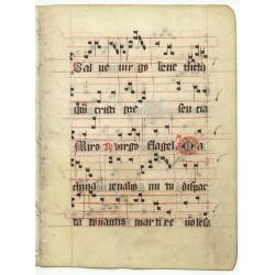
Leaf on vellum from an antiphonary.
A more than 600 years old antiphonary leaf, written in Besançon, in 1370. Musical notation on 4 bars, the staves are in red and the notes in black: numerous pen-flourish...
Place & Date: Besançon, 1370
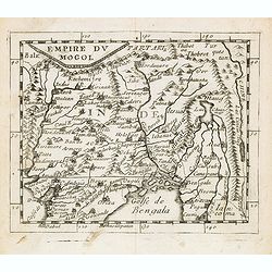
Empire du Mogol.
Uncommon miniature map of the Mongol empire from Pierre Duval's La Geographie Universeille dated 1676. Following his Cartes de geographie in 1657, Pierre Duval published ...
- $150 / ≈ €140
Place & Date: Paris, 1676
Le Theatre de la Guerre Dans les SEVENNES avec les Plaines de environs.
A copperplate, hand-colored map showing the french civil war. Includes a chart with the roads.The map refers to the Camisards' rebellion in the Cévennes mountains betwee...
Place & Date: Rotterdam, 1703
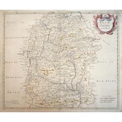
Wiltshire.
An attractive late 17th century map of Wiltshire that appeared in the first edition of Camden's Britannia in 1695. The maps from this publication were produced by Robert ...
Place & Date: London, 1695
Castilliae veteris et novae descriptio.
A very attractive map of Castillia, with Madrid and Toledo in the centre of the map.
Place & Date: Amsterdam, 1633
![[A magnificent 18 inch. (46 cm.) diameter celestial globe] URANOGRAPHIA / SYDERUM ET STELLARUM / in Singulis Syderibus conspicuarum / exhibens Delineationem accuratissimam, / qua / ex Observationibus Astronomi plane Singularis / IOHANIS HEVELII...](/uploads/cache/48959-250x250.jpg)
[A magnificent 18 inch. (46 cm.) diameter celestial globe] URANOGRAPHIA / SYDERUM ET STELLARUM / in Singulis Syderibus conspicuarum / exhibens Delineationem accuratissimam, / qua / ex Observationibus Astronomi plane Singularis / IOHANIS HEVELII...
RARE FIRST STATE OF THIS CELESTIAL TABLE GLOBE, 46 cm in diameter, produced by Gerard and Leonard Valk at the beginning of the 18th century. The globe comprises of t...
- $95000 / ≈ €88893
Place & Date: Amsterdam, 1711
![[Title page] Atlas Universel. . .](/uploads/cache/48053-250x250.jpg)
[Title page] Atlas Universel. . .
Beautiful title-frontispiece from the famous universal atlas initiated by geographers Gilles Robert and his son Didier Robert de Vaugondy, revised, corrected and enhanced...
Place & Date: Paris, 1806
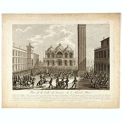
Prise de la ville de Venise le 3 Floreal An 5. Tout un côté de la place St-Marc à Venise alloit être incendié par les Barcaroles... (N°7).
Showing St. Marco square in Venice. After a design by Thomas-Charles Naudet. Engraved by Pierre-Adrien Le Beau. Print belonging to a suite illustrating the General Napole...
Place & Date: Paris, Jean, 1797 -1802
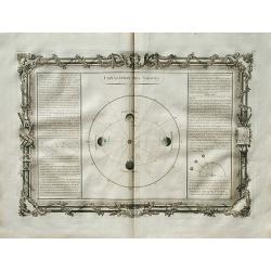
Explication des Saison.
A decorative celestial chart representing the Earth's revolution around the sun. Left and right a text box with information explaining the phenomenon of the seasons. Publ...
Place & Date: Paris, 1761
![[Portrait] Johannes Baptista Homann . . .](/uploads/cache/36599-250x250.jpg)
[Portrait] Johannes Baptista Homann . . .
Stunning full portrait of the Imperial Geographer of the Holy Roman Empire, Johann Baptist Homann (1664-1724) who was born in the Bavarian town of Kammlach. Educated at a...
Place & Date: Nuremberg, c.1740

Desciption de lopulente et manifique ville de Venise.
Extremely rare panoramic view of Venice and neighboring islands (Murano, Burano, Torcello and Mazorbo), clearly depicting the city's architectural landmark. The surroundi...
Place & Date: Paris, 1646
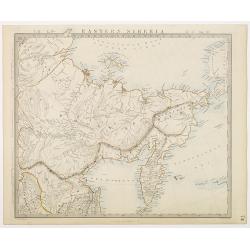
Eastern Siberia.
Very detailed steel engraved map of Siberia, including the peninsular of Kamchatka. Relief shown by hachures.The map is based after Piadischev, Lutke and others.Engraved ...
Place & Date: London, Edward Stanford, 1864
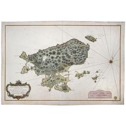
![Carricta meridionalis, [vulgo], The South part of Carrick / auct. Timoth. Pont.](/uploads/cache/42489-250x250.jpg)
Carricta meridionalis, [vulgo], The South part of Carrick / auct. Timoth. Pont.
Very detailed map and striking map of the south part of Carrick in Scotland. Rare from Joan Blaeu's Atlas Major.Prepared by Timothy Pont and Robert Gordon. The map is enh...
Place & Date: Amsterdam, 1662
Selling price: $30
Sold in 2020
![[Indians attacked near Cartagena.]](/uploads/cache/40076-250x250.jpg)
[Indians attacked near Cartagena.]
When the governor of Cartagena, Alonso de Ojeda, led a party of Spanish soldiers into the interior to search for gold, they were attacked by Indians with such ferocity th...
- $125 / ≈ €117
Place & Date: Frankfurt, M.Merian, 1633
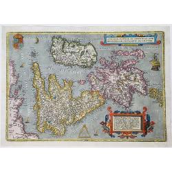
Angliae, Scotiae, Et Hiberniae Sive Britannicae Insularum Descriptio
Ortelius' first map of the British Isles, from Ortelius' Theatrum Orbis Terrarum', German language edition, Antwerp 1572.Title in a roll work cartouche at top right. Crow...
Place & Date: Antwerp, 1572
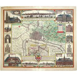
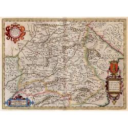
Marchionatus Sacri Romani Imperii.
Beautiful and decorative "carte à figures"- plan of the city of Antwerp with its surroundings. Three panoramic city views of Antwerp and ten vignette views of ...
Place & Date: Amsterdam, 1678
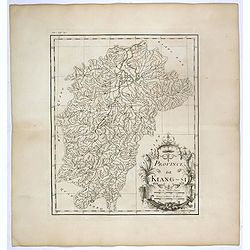
Province de Kiang-Si. Jiangxi 江西 province.
An important map of Jiangxi 江西 province. With a quite elaborately pictorial cartouche featuring a rococo chinoiserie ornamentation, engraved by Guélard. The map itse...
- $200 / ≈ €187
Place & Date: Paris, P.G. Le Mercier, 1735
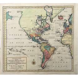
Nieuwe Kaart van het Westelykste Deel der Weereld. . .
A very decorative map of the Western part of the World by Isaac Tirion. The Americas display a speculative river to the West through North America, beginning at the Great...
Place & Date: Amsterdam, 1754
Selling price: $140
Sold in 2022

A unique composite atlas with updated Porro maps.
Unique composite atlas containing in total 84 maps - 82 maps engraved by Girolamo Porro and heavenly reworked around 1686 and 2 newly engraved maps; Piccola Tartaria (Cr...
Place & Date: Venice, 1686
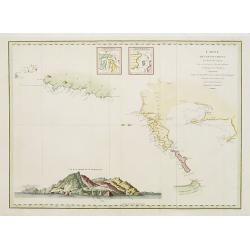
Saint Pierre, Plan de l'Ile de .., au Sud de Terre-Neuve.
A highly detailed map based on a survey by Fortin, and published by the 'Dépôt Général de la Marine' (the maritime chart printing office of the French government) in ...
Place & Date: Paris, 1763
Selling price: $200
Sold in 2022
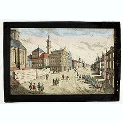
Prospect der Strasse gegen der Kirche der Recolecten in der obern Stadt zu Quebec. Vuë de la Rue des Recolets dans la haute Ville de Quebec.
A so-called optical print showing a decorative imaginary town view of Québec, with a street view with soldiers marching and pedestrians, an idealized view depicting Qué...
- $450 / ≈ €421
Place & Date: Augsburg, ca. 1780
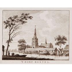
't dorp Boxtel.
Rare print of a view on the town of Boxtel (near Eindhoven), from Vaderlandsche gezichten of afbeeldingen.. by J.Bulthuis, printed by H.Gartman in Amsterdam.
- $150 / ≈ €140
Place & Date: Amsterdam, 1786-1792
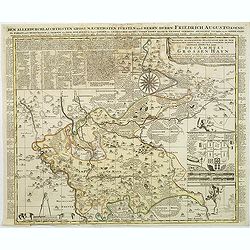
Accurate geographische delineation der in dem Meisnichen creisse des chufurstenthums sachsen liegenden dioeces oder des ammtes grossen hayn
Very detailed map prepared by Adam Frederic Zürner (1680-1742). Surrounded with legends and decorated in the lower right corner with a plan of a royal campement. The tow...
- $90 / ≈ €84
Place & Date: Amsterdam, 1711

Pascaerte van 't Westelyckste Deel van Oost Indien, van Cabo de Bona Esperanca tot C.Comorin..
An eye-catching chart of the western part of the Indian Ocean and its adjacent coasts of East Africa, Arabia with the Red Sea and the Arabian Gulf, Iran, Pakistan and we...
Place & Date: Amsterdam, 1666
Carte des découvertes au Nord du Japon.
Chart of the discoveries to the north of Japan, in 1643 by the Dutch ships Castricum and Breskens. In two small insets in the top of the chart the province of Osju is dep...
Place & Date: Paris, 1798
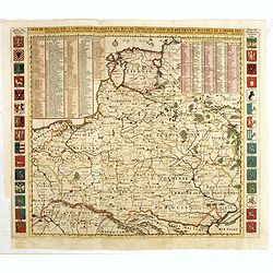
Carte De Pologne Avec La Chronologie Des Rois Et Des Ducs De Lithuanie, Ainsi Que Des Grands M. De L'Ordre Teutonique Les Evechez et Archeveches, et Les Armes Des Provinces . . .
Map of Poland with a key table to the towns, and 30 coats of arms on both sides, extending south the Black Sea. From Chatelain's monumental 7-volume "Atlas Historiqu...
- $1750 / ≈ €1638
Place & Date: Amsterdam, 1720
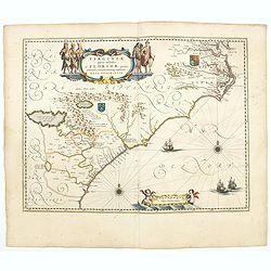
Virginiae Partis Australis, et Floridae Partis Orientalis.
Blaeu based this map on the Mercator-Hondius of 1606. A number of geographical improvements, however were incorporated, although two large fictions lakes accompanied by e...
- $2000 / ≈ €1871
Place & Date: Amsterdam, 1644
La Ribette a nos saules! Au Diable la Seringue Vive le Clysoir.
A charming and delightful hand colored etching in the grand French style of the early nineteenth century from "Musee Grotesque No. 20" : La Ribette a nos saules...
Place & Date: Paris ca 1816-1820
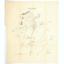
Battle of Colenso, 15th December 1899, Situation about 7 a.m.
[Map no.6] The battle of Colenso was the third and final battle fought during the Black Week of the Second Boer War. It was fought between British and Boer forces from th...
Place & Date: Edinburgh, London, ca 1900
Selling price: $14
Sold in 2021
![[two sheets] Atlas Nouveau, contenant toutes les parties du Monde, ou sont exactement remarqués les empires, monarchies, royaumes, estats, republiques & peuples qui sy. . . [with] Table des Cartes etc.](/uploads/cache/84499-250x250.jpg)
[two sheets] Atlas Nouveau, contenant toutes les parties du Monde, ou sont exactement remarqués les empires, monarchies, royaumes, estats, republiques & peuples qui sy. . . [with] Table des Cartes etc.
Two engraved sheets title and index pages - from the monumental work. Atlas Nouveau, contenant toutes les parties du Monde, ou sont exactement remarqués les empires, mon...
Place & Date: Amsterdam, 1692
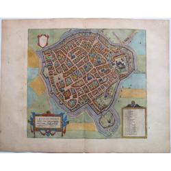
St. Omer. - S. Audomari Fanum S. Aulmer, ...
A handsome birds-eye view/map of the northwest French city of St. Omer, from "Civitates Orbis Terrarum", in fine color. From the uncommon forth volume of Brau...
Place & Date: Cologne, 1588
![[No title - Central Africa] Guinee IIe. Feuille.](/uploads/cache/24255-250x250.jpg)
[No title - Central Africa] Guinee IIe. Feuille.
Attractive map of the African coast around the Gulf of Guinea, encompassing the area between Ghana and Angola. Boundaries outlined in hand color.From theAtlas moderne ou ...
Place & Date: Paris, ca 1783

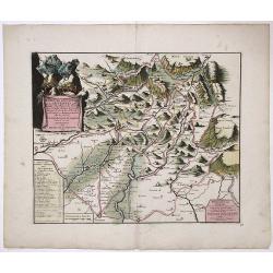
Les vallées du Piemont. Habitees par les Vaudois ou Berbets. . .
Detailed map of Piedmont region covering French and Italian territories. Surrounded by a French text description "Description des vallées du Piemont qu'habitent par...
Place & Date: Paris, 1690

Nader prolongatie van het Octroy voor de Westindische Compagnie voor den tyd van nog dertig jaaren. . .
A proclamation by the Dutch States General, dated 1761, extending the charter of the Dutch West India Company for another thirty years. Like the 1730 proclamation, it has...
Place & Date: Amsterdam, 1761
![[72] Barbarie.](/uploads/cache/12844-250x250.jpg)
[72] Barbarie.
Charming chart of the harbour of the town of Algiers in Algeria. Showing town and harbour plan, with soundings, anchorages, rocks, shoals, fortifications and lighthouses....
Place & Date: Marseille 1764
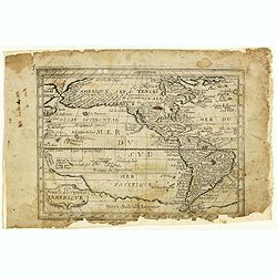
Nouvelle description de lamerique.
Jollain published this rare map of America in 1667. State 3, with the scale, erased, as it fictitious strait on the west coast of North America which Le Royaume de Quiuer...
- $450 / ≈ €421
Place & Date: Paris, 1667

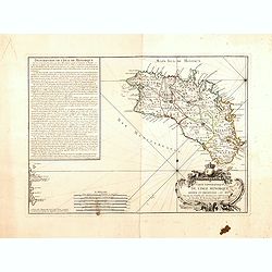
Il Governo di Guascogna con porzione del Governo di Guienna.
Rare regional map of France of the Périgord, Guienne, Gascogne and the Béarn published by Carli Pazzini in Siena.
Place & Date: Siena, 1792
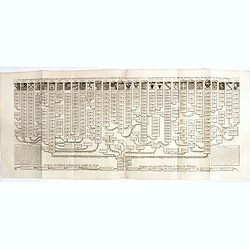
Nouvelle carte genealogique des souverains et des familles illustres aliez a la maison ou aux decendans de la famille roialle de Piaste roi de Pologne. . .
A two sheet engraving of the genealogical family tree of Poland from 804 AD to the time of publication. The tree extends throughout Europe and is headed by the arms of 30...
- $150 / ≈ €140
Place & Date: Amsterdam, 1719-1732
Leaf on vellum from an antiphonary.
A small vellum leaf from a processional*, written in the 1500's in Spain (?). The pin pricks to draw the red lines can still be seen. There are many initials in red. *Pro...
Place & Date: Spain ca.1500
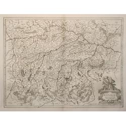
Bavaria Ducatus.
Map depicting Germany province of Bavaria.The plate was engraved by S.Rogiers for Jodocus Hondius. In 1629 Willem Blaeu acquired the copperplate and used the plate in his...
Place & Date: Amsterdam, 1640
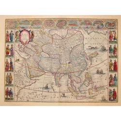
Asia noviter delineata..
From 1633 the members of the Blaeu family were official cartographers to the United East India Company and, as such, had access to the most up-to-date cartographic inform...
Place & Date: Amsterdam 1650
L'Amerique ou le Nouvelle Continent.. Dedieé et presenteé a monseigneur Law.
State one. The map has been prepared by Jean Baptiste Nolin (the elder) has a dedication to Monseigneur LAW controlleur general des finances .Rare general map of the Amer...
- $2200 / ≈ €2059
Place & Date: Paris, 1720