AN EXCEPTIONAL AND VERY RARE PAIR OF CELESTIAL AND TERRESTIAL GLOBES. |
||||||||||||||||||||
|
||||||||||||||||||||
|
|
||||||||||||||||||||
$375000 / ≈ €350894
$375000
|
Views: 369
Watchers:
4
|
|||||||||||||||||||
Description
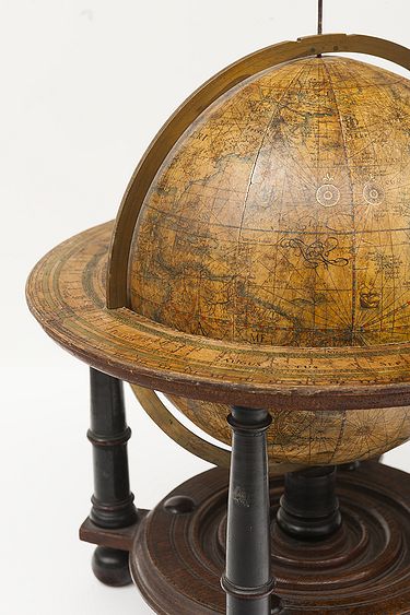
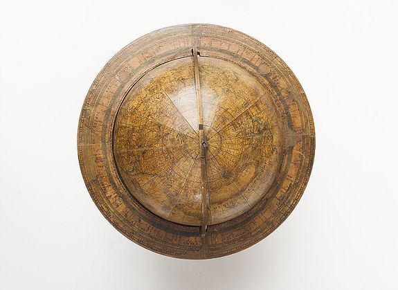
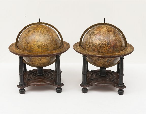
The diameter of the terrestrial and celestial globe is 9 inch (23 centimeters) and each globe is made up of a set of 12 engraved gores and Arctic ice caps, printed on paper and mounted on a sphere of papier maché. Each sphere is mounted in a graduated brass meridian ring with the production number stamped at the back of the ring. The hour circles are missing.
Both globes are mounted on four-legged ebonized oak Dutch stands, which support the horizon ring. The legs are connected by two crossbeams which support a circular base plate with central support for the meridian ring. The horizon rings are covered with printed paper.
With usual defects: paper equinoctial tables present gaps that are filled and restored; small splits along gores; several partially deleted entries; on the globe, the date 1602 and the text of the cartouche in America, are illegible ; small scattered spots but in general in good condition for such an early globe pair of which presently only 19 pair are recorded.
These 9-inch globes are among the rarest since very few copies of them are known to exist, in comparison with the smaller or larger globes of Blaeu (4, 6, 13.5, and 26 inches).
Blaeu's terrestrial globes were highly valued and were much in demand, because of the care with which they had been prepared, because of the efforts to give the latest information on discoveries, and because of the loxodromic lines which made them of special value to navigators.
His celestial globes were appreciated for the fact that he had been the pupil of Tycho Brahe, who was himself known to be the greatest astronomer of his time (Stevenson).
Price on request
DIFFERENT STATES OF THE 9-INCH GLOBES
According to Peter van der Krogt in ‘Globi Neerlandici: the Production of Globes in the Low Countries’, the following states are known.
Terrestrial globes
There is no known copy of the first state of 1602. The second state was published around 1618-1621 and again there are no known examples.
All the states are dated 1602 but the second state must have been published after 1618, since it includes the discoveries of Schouten and Le Maire (1615-1617) but not the name “Blaeu”. This example of a 9-inch terrestrial globe is a third and last state according to Peter van der Krogt. Elly Dekker in her Globes at Greenwich: a Catalogue of the Globes and Armillary Spheres in the National Maritime Museum, Greenwich of 1999 makes no distinction between the different states. The third state can be divided into states 3a and 3b. All globes have a different production number, some of which are illegible today. This terrestrial 9-inch globe is marked with ‘fabr. nr. 4’.
Celestial globes
There are two known states. There is only a catalogue record of the first state of 1602, no specimen of which is presently known. The second state was presumably published after 1621. All 30 known celestial globes are in a second state, as is this one, which is marked with ‘fabr. no. 12’.
OTHER KNOWN EXAMPLES
This set of terrestrial and celestial globes are comparable to the pairs of globes in the collections of the following museums, although the production number is illegible on some globes (indicated below with a dash).
- Amsterdam, Het Scheepvaartmuseum, inv. no. B 25, Terr.: 3b (‘fabr. no. 7’), Cel.: 2 (‘fabr. no. 4’)
- Rotterdam, Maritiem Museum, inv. nos. M475 and M473, Terr.: 3b (‘fabr. no. -’) Cel.: (‘fabr. no. 4’)
- Greenwich, National Maritime Museum, inv. no. GLB0083, Terr.: 3b (‘fabr. no. 23’) Cel.: 2 (‘ fabr. no. -’) Idem, inv. nos. GLB0152 and GLB0151, (‘fabr. no. 1’) Terr. 3b (‘fabr. no. 1’) Cel.: 2 (‘fabr. no. 2’)
- Brussels, Koninklijke Bibliotheek Albert I, inv. no. IV 10189, Terr.: 3b (‘fabr. no. -’) Cel.: 2 (‘fabr. no. XXIII’)
- Dresden, Staatliche Kunstsammlungen, Mathematisch-Physikalischer Salon, inv. no. E I 34 (formerly Halle, Hematmuseum), Terr.: 3b (‘fabr. no.-’) Cel.: -
Since 1993
Since the publication of van der Krogts book only two pair of the 9 inch globes surfaced.
6. A pair was sold at a Christie’s Sale (London, 10 July 2002, Lot 11 price realized £248,650 ($385,408), example with usual restorations. See: www.christies.com lot finder
7. This pair sold at P.Bergé, Paris, sale 8 June, 2016, Lot 205.
X-RADIOGRAPHS
The authenticity of this pair of globes is based on X-radiographs provided by Rene Gerritsen. They were both made at the same time and have the same hand. A look inside the globes shows that the wooden spindle, spheres, including the core, are identical.
SELECTED BIBLIOGRAPHY :
-Blaev, I. Tweevovdigh onderwiis van de hemelsche en aerdsche globen;: het een na de meyning van Ptolemevs met een vasten aerdkloot; het ander na de natuerlijcke stelling van N. Copernicvs met een loopenden aerdkloot, 2 vols., Amsterdam (ter drukkerye van Ioan Blaev) 1647, vol. 1.
- Dekker, E. Globes at Greenwich: a Catalogue of the Globes and Armillary Spheres in the National Maritime Museum, Greenwich, Oxford & Greenwich 1999.
- Dekker, E. and P. van de Krogt, Globes from the Western World, London 1993.
- Kanas, N. Star Maps, History, Artistry and Cartography, 2nd edition, New York, 2009.
- Keuning, J. Willem Jansz. Blaeu : A Biography and History of his Work as a Cartographer and Publisher, revised and edited by Marijke Donkersloot.
- Koeman: Atlantes Neerlandici, vols. 2 and 4.
- Krogt, P van der. Globi Neerlandici, the Production of Globes in the Low Countries, Utrecht 1993.
- Krogt, P. van der. Old Globes in the Netherlands, Utrecht 1984.
- Lankford, J. History of Astronomy. An Encyclopedia. New York, 2001.
- Mosley, A. Bearing the Heavens. Tycho Brahe and the Astronomical Community of the late Sixteenth Century, Cambridge 1997.
- Pelletier, M. Cartographie de la France et du monde de la Renaissance au Siècle des Lumières, ‘ Les Globes dans les collections françaises aux XVIIe et XVIIIe siècles’, Paris 2001.
- Stevenson, E. L. Terrestrial and Celestial Globes, New Haven 1921, Vol. 2.
- Idem, Willem Janszoon Blaeu, a Sketch of his Life and Work, New York 1914.
- Schilder, G. Monumenta Cartographica Neerlandica, vol. 3, Alphen a/d Rijn, 1987.
- Wildeman, D. De Wereld in het klein. Stichting Nederlands Scheepvaartmuseum, 2006.
THE TERRESTRIAL GLOBE
Blaeu’s terrestrial globes were highly valued and much in demand, due to the care with which they were prepared and because of the efforts to provide up-to-date information about the latest discoveries. They were the most advanced cartographic documents of the day.
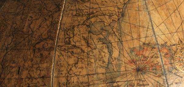
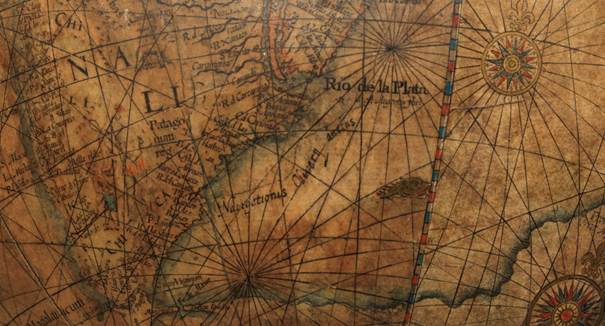
The geographical details in the seas and oceans are engraved and include loxodromes for the 32 compass points. These loxodromic lines made them valuable to navigators. In addition, they represented the curves of the wind directions.
Willem Jansz Blaeu collected information that Dutch mariners gathered from around the world and brought back to Amsterdam. Crews were instructed to record information about the lands they visited and the skies they saw. Blaeu incorporated these observations in maps and globes. Through his web of contacts and thanks to assiduous research, he was also able to obtain the most recent information about the latest discoveries in the western hemisphere and the South Pacific, where Dutch explorers were particularly active at the time.
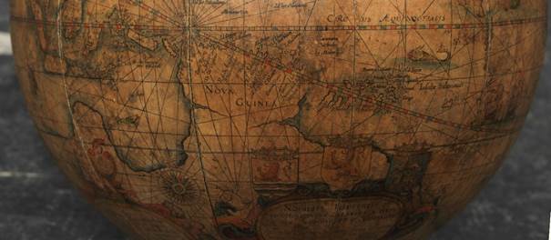
Since the globe was published after 1618, Blaeu was able to include the discoveries made by Henry Hudson in his attempt to find a passage to the East Indies. He also included recent Pacific discoveries of the celebrated voyages of Willem Cornelis Schouten and Jacob Le Maire, who both traversed the South Pacific and the Atlantic. The findings of Schouten and Le Maire in the Tierra del Fuego region are also incorporated.
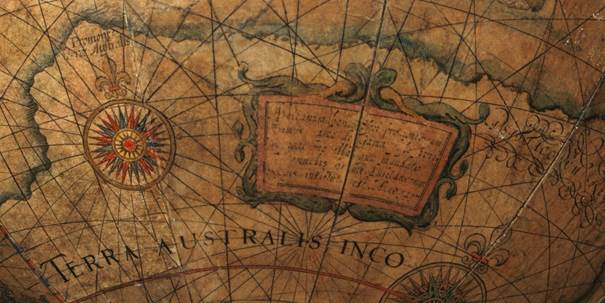
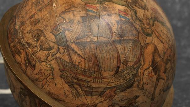
The Strait of Le Maire is drawn and the hypothetical southern continent is labeled ‘TERRA AUSTRALIS INCOGNITA MAGALANICA’. Olivier van Noort’s track is drawn and labeled. His route is indicated with a broken line and the words: ‘Navigationis Olivierij ductus’ (several times). There are various decorative features, such as animals on the different continents, many ships on the high seas, and allegorical and mythical figures around the cartouches.
The 9-inch globe is not just a smaller version of the one published in 1599. Drawings of animals and people do often correspond to those on the earlier globe, but Blaeu made several significant changes.
- The west coast of North America is drawn differently and the river system of Brazil is altered.
- The hypothetical southern continent is labeled: TERRA AUSTRALIS INCOGNITA MAGALLANICA.
- There are nine ocean names in handsome curling letters: Mare Congelatum, Mare Atlanticum, Oceanus Aethiopicus, Mare Arabicum et Indicum, Mare di India, Oceanus Chinensis, Mar del Zur, Mare Pacificum, Mar del Nort.
- Willem Blaeu, always eager to display the latest discoveries, traced the route of Van Noort’s route with a broken line. The findings of the voyage of Schouten and Le Maire in the Tierro del Fuego region are included, despite the 1602 date (names: Fr. Le Maire, Mauritius, Staten Landt, C.Hoorn, I.Barneveltij).
TECHNICAL DETAILS
The diameter of the terrestrial globe is 23 cm (9 inches) and the overall dimensions are 38 cm high and 33.5 cm wide. The globe is dated 1602 but was published after 1621, since it includes the discoveries of Schouten and Le Maire.
The globe has 12 full, copper engraved, hand-colored (with gold heightening) and varnished gores running from the north to the south equatorial pole. The sphere is mounted in a graduated brass meridian ring (clockwise from N: 0° - 90°; 90° - 0°; 90°- 0°; 0°- 90 °; numbered every 10°, with 1° division). The meridian ring is signed with the production number ‘4’.
There are five cartouches, four of them in the southern continent and one in North America. Loxodromes for 32 points of the compass are drawn in the seas and oceans.
The horizon ring is copper-engraved on paper and has a surface coating.
Scales (from inside to outside): for the zodiac (12 times 0° - 30°; numbered every 10°, with 1° division), with the Latin names and the symbols of the signs of the zodiac; for the Gregorian calendar labeled: Calendarium antiquum commune (numbered every 10 days, with 1-day divisions) with the Latin names of the months; and for the twelve wind directions with names in Greek and Latin, and twelve compass points with names in Dutch. The zodiac starts at the Julian calendar scale 10. 25 days after the beginning of March, that is, the first point of Aries is at 11 March 6 hours; with respect to the Gregorian calendar, the first point of Aries is at 21 March 6 hours.
CARTOGRAPHY
Latin. Co-ordinates: meridians every 10°. Parallels every 10°. The prime meridian runs west of the Azores (through Corvo or Flores). The equator is graduated (0° - 360°; numbered every 10°, with 1° division) and labeled CIRCULUS AEQUINOCTIALIS. The ecliptic is graduated (12 times 0° - 30°; numbered every 10°, with 1° division) and provided with the symbols and signs of the zodiac. The vernal equinox is at L 0°. There is a latitude scale along the prime meridian (N & S 0° - 90°; numbered every 10°, with 1° division). There are labels for the Circulus Arcticus, the Tropicus Cancri, the Tropicus Capricorni and the Circulus Antarcticus.
GEOGRAPHICAL NOTES
There are loxodromes for 32 compass points. The Strait of Le Maire is indicated and the hypothetical southern continent is labeled: TERRA AUSTRALIS INCOGNITA MAGALANICA. Olivier van Noort’s track is drawn and labelled Navigationes Olivierij ductus, Exitus Olivierij and reditus Olivierij.

CARTOUCHES
The globe is decorated with five cartouches, four of them in the southern hemisphere and one in North America.
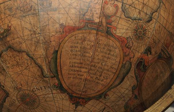
The oval dedication cartouche is in the hypothetical southern continent (L 180° - 240°, 20° - 60°) and topped with the coats of arms of Holland, Zeeland and West Friesland.
There are several figures on the left, right and bottom, among them a woman pouring water into a scale and Justitia with a sword and the scales of Justice.
The text reads: NOBILISS: IS ILLUSTRIS: IS-Q(UE) | D.D. [Dominis] HOLLANDIAE, ZELANDIAE, AC WEST: | PHRISIAE ORDINIBUS PP: P: [= Patribus Patriae] CLEMENTISS. IS | Hanc | Terrae Marisq(ue) Sphaeram, summâ diligentiâ | accuratissime fabricatam; Debiti honoris gra: | tiq(ue) animi testimonium, L[ibens] M[erito] D[at] D[icat] D[edicat] Guilielmus Janssonius Blaeu | Anno 1602.
(To the noblest and illustrious Lords, the States of Holland, Zealand and West Friesland, the most clement Fathers of the Fatherland, this globe of the land and the sea, constructed most accurately with the utmost diligence, is given, consecrated and dedicated willingly and rightly as a testimony of due honor and a thankful heart, by Willem Jansz Blaeu, in the year 1602.)
The Notice to the reader is in an oval cartouche with angels on either side and a cherub holding a vertical sundial at the top. It is placed in the hypothetical southern continent at L 120 °- 180°, S 20 ° - 70°. It contains the following Latin inscription: En denuo, Geographiae | studiose, terrestrem contrac: | tiori formâ globum; multo, | quam antehac unquam, | emendatius et auctius confec: | tum; et ventorum spiris navi: | gantium co(m)modo exquisitius | adornatum; nec non navi: |gationis curriculo, ab Oli | verio van noort Batavo, | in orbem peracto, notatu(m) | Auctiore Guilielmo Jansonio Blaeu. (Once again, lover of geography, a terrestrial globe in reduced form, emended and augmented much more thoroughly than before, and for the sake of seafarers, exquisitely adorned with the wind spirals [loxodromes], and with the depiction of the route that the Dutchman Olivier van Noort followed around the world. Willem Jansz Blaeu. Anno 1602).
Olivier van Noort, the Dutch navigator mentioned in the cartouche, embarked on his journey in 1598. He crossed the Strait of Magellan to travel to the Dutch East Indies and then went to Cape Town. He returned to Rotterdam on 26 August 1601. Van Noort was the first Dutchman to circumnavigate the world.
Inscribed in the cartouche on the hypothetical southern continent, below the Cape of Good Hope, at L 40° - 80°, N 45° - 6O°, with two mermaids: Africanum bonae Spei promontorium | primus Vasco de Gama superavit; | navigatione illa quae mandato | Emanuelis primi, Lusitanorum | Regis, instituta est. Anno 1497. (Vasco da Gama conquered the African Cape of Good Hope, during the voyage begun under the command of Emanuel I, King of the Portuguese, in the year 1497.)
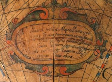
Magallanicu(m) fretum a Magellano qui | illud an(n)o 1519 primus pervium [invenst] nome(n) | sortitum est: postea ab Anglis quidem lustratu(m) | sed nunc demum pleniori cognitione ab | Olivierio van noort Batavo illus: | tratum Anno 1600. (The Strait of Magellan was named after Magellan, who was the first to find a way through here in 1519. It was later passed by the English but has now at last been made known through a fuller examination by Olivier van Noort, the Dutchman, in the year 1600.)
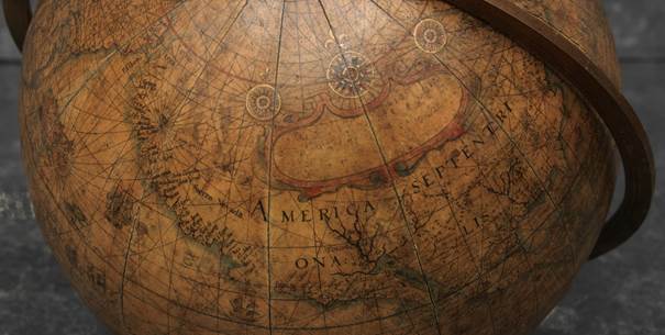
The text of the two cartouches placed at the bottom of Africa and at the bottom of America is partially erased. That of the cartouche placed in North America, speaking of the discovery of America by Christopher Columbus in 1492, is totally illegible.
Willem Blaeu, always eager to display the latest discoveries, traced Van Noort’s route with a broken line.
THE CELESTIAL GLOBE
A celestial globe is a sphere on which a map of the heavens is drawn, engraved or pasted. Because it is a model of the firmament as seen from an external point, rather than from a geocentric point, the constellation figures were traditionally represented from the back, as if they turned their faces to the earth. Celestial globes were used to represent the constellations without the distortions found on flat maps. They enabled graphical solutions to some basic problems of positional astronomy, for example, the relationship of the stars to the horizon, meridian, or ecliptic at a given time.
The earliest extant celestial globe is that borne on the shoulders of The Farnese Atlas, a Roman statue currently preserved in the Naples National Archeological Museum. It is the oldest surviving pictorial record of western constellations but has long been presumed to represent constellations mapped in earlier Greek work. It dates to Roman times, around AD 150, and is a Roman copy of a Hellenistic sculpture of a man kneeling with the celestial spheres, not a globe, weighing heavily on his shoulders. Eudoxus of Cnidus owned and described a globe more than five centuries earlier.
In Almagest, an astronomical guide written around AD 150 by Ptolemy (c. AD 100 - c. 170) offered advice on the making of a celestial globe. He recommended a dark background with yellow stars of a size commensurate with their stellar magnitude. In contrast to the style of Eudoxus of Cnidus (c. 408.- 355 BC) and his followers, Ptolemy drew his constellation figures dimly so as not to detract from the stars. The Almagest served as the basic guide for Islamic and European astronomers until about the seventeenth century.
Celestial globes were made at a very early date in the Islamic world, and arrived in Europe through Arabic channels in the middle ages. China had its own tradition of celestial globe production that dated back to about the fifth century AD.
A number of celestial globes were made from the sixteenth to the eighteenth centuries, some by people who were also famed for their exceptional maps. Apart from the early production center in Nuremberg, there was the famous mapmaker Gerard Mercator (1512-1594).
In 1555 he made the largest astronomical gores that had been seen until then, and this influenced several subsequent planispheres and globes. Like their terrestrial counterparts, the celestial gores were consecutive segments whose images were produced on a woodblock or copperplate and then printed. Typically, there were a total of 12 gores (or 24 half gores), each representing 30 degrees of celestial longitude.
The first maker of globes from the northern Netherlands was the cartographer Jacob Floris van Langren (before 1525-1610). He published his first terrestrial and celestial globes in 1586 with a diameter of 32.5 cm, the terrestrial globes being based on the work of Mercator. The second edition of the celestial globe was improved after the observations of the southern hemisphere by Pieter Dirkz Keyser and Frederik de Houtman were incorporated by the geographer Petrus Plancius (1552- 1622), who was also influential as a globe maker.
Two other famous Dutch mapmakers produced celestial globes: Jodocus Hondius the Elder (1563-1612), one of the most notable engravers of his day, and Willem Jansz Blaeu (1571-1638).
THE CELESTIAL GLOBES BY WILLEM JANSZ BLAEU
Willem Janszoon (Jansz for short) Blaeu became interested in mathematics and astronomy at an early age, and showed such promise that he was accepted as a pupil by Tycho Brahe, the greatest astronomer of his day, and went to study at Brahe’s observatory on the island of Hven, Denmark (modern Ven in Sweden.
)
 In the winter of 1596/1597, he made his own observations of the skies. When he returned to the Netherlands he made his first celestial globe, 34 cm in diameter, based on Brahe’s new but as yet unpublished star catalog. This globe was published in 1597/1598 and was masterfully engraved by Jan Saenredam.
It records the early seventeenth-century knowledge of the skies, including recently discovered stars. The fixed stars are placed according to the observations of Tycho Brahe.
In addition to the traditional constellations attributed to Ptolemy, there are others that had been discovered more recently in the southern hemisphere as a result of Dutch exploration in the East Indies, principally by the Dutch explorer Cornelis de Houtman. He also included several non-Ptolemaic constellations along with the 12 southern constellations of Plancius, which were based on the observations of Cornelis’s brother Frederik. They consist of 300 positions of the southern constellations measured by the latter. With their wealth of astronomical information, Blaeu’s celestial globes demonstrate his great interest in astronomy. At the beginning of his career, Blaeu focused mainly on the production of celestial and terrestrial globes. His later celestial globes followed Saenredam’s style.
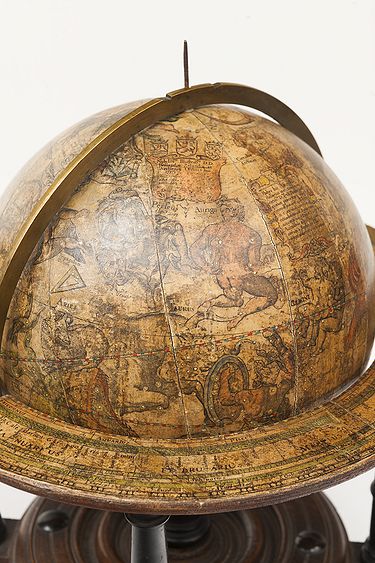
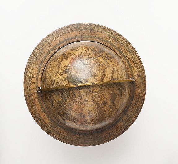
This celestial globe was made by Blaeu, whose signature, Auctore Guilielmo Janss. Blaeu, is engraved in the sphere. It was made in Amsterdam in 1602, but not published until after 1621. It is 9 inches (23 cm) in diameter and has the same construction as the terrestrial globe. In order to spin on its axis, the sphere was held in a meridian ring, which was adjustable for the user’s latitude within the original wooden stand.
The top of the stand served as the horizon circle, and a printed calendar and wind rose are pasted onto it. Near the north pole of the meridian ring, used to be an hour circle, the pointer of which turned as the globe revolved.
The celestial globe is covered with 12 full ecliptical gores from the south to the north ecliptic poles. The gores are copper engraved, hand-coloured (stars in gold), and varnished. The overall dimensions of the globe are 38 cm in height and 33.5 cm in width. The number ‘12’ is stamped on the meridian ring. The celestial sphere is an external projection of the epoch of 1600.
The astronomical content combined with the new drawing style made this celestial globe the best and most modern of its time.
The cartography on the globe is in Latin, and the coordinates have circles of latitude every 30° (gore edges).
The celestial globe is decorated with the symbols and signs of the zodiac. The equator is graduated [0° - 360°; numbered every 10°, with 1° division]. There are labels for the Circulus Arcticus, the Tropicus Cancri, the Tropic(us) Capricorni, the Polus Antarticus, the Polus Eclipti[cae], Borealis, the Polus Eclipticae Borealis, the Colorus Aequinoc[ialis] and the Colorus Solstitiorum.
There is a cartouche crowned by the coats of arms of Zealand, Holland and Friesland to the right of Cassiopeia at RA 50° - 80°, N 50° - 80°, with a dedication similar to the one on the terrestrial globe: ‘Nobilissis Illustrissis DD Hollandiæ Zelandiæ et Westfrisiæ ordinibus DD: suis Clementissis hunc astriferum inerrantium stellarum globum summa cura et industria adornatum, debiti obsequi et gratitudinis DDD Guilielmus Janssonius Blaeu 1602]’ (the date is legible but part of the bracketed text is not). (To the most noble and illustrious Lords, the States of Holland, Zeeland and West Friesland, the most clement: this celestial globe of the fixed stars, prepared with great care and diligence, dedicated by Willem Jansz Blaeu in the testimony of his obedience and gratitude 1602).
As on the terrestrial globe, the dedication cartouche is surmounted by the coats of arms of the three provinces mentioned. It is placed between the constellations of the Plough and Cassiopeia.
The Notice to the reader is in a cartouche to the right of the constellation of Auriga: [RA 90° - 120°, N 30° - 60°]. It contains the following Latin inscription: Habes hîc Astrophile, | stellarum inerrantium ex | certissis [is] D [omini] Tych: Brahe (mei | quo(n)dam præceptoris) obser- |vationib(us), numero & disposi: | tione prae aliis, a(n)no 1600. ac- |comodatarum Sphæram | accuratissime expolitam ; et | Australibus asterismis quod | novum | à Frederico Hout: |ma(n)no observatis exornatam | Auctore Guilielmo Janss[o] Blaeu (Here, astrophile, you have a very accurate and carefully corrected globe of the fixed stars, following the faithful observations of the noble Tycho Brahe (at one time my teacher). Better adapted than others for the year 1600 as regards their number and position, and what is new, adorned with the southern stars as recently observed by Frederik de Houtman, By Willem Jansz Blaeu).
The number and arrangement of the stars of the globe follow the most accurate observations of Tycho Brahe, Blaeu’s teacher, with added comments adjusted in 1600, and supplemented by a representation of the constellations of the southern hemisphere recently discovered by Frederik de Houtman, the Dutch explorer and astronomer.
A figure or a sign represents the stars of between the first and sixth magnitude, while nebulae have their own representation. The beautiful constellations, drawn in the style of the Dutch painter Pieter Jansz Saenredam, all have Latin names. There are 48 constellations by Ptolemy. Blaeu added 10 in the southern hemisphere, including Coma Berenices and Antinous, the names they bore in antiquity. The legend in the constellation of Cepheus refers to one of its stars: ‘Haec stupendæ magnitudinis stella insolito fulgore anno 1572 in Cassiopeia sede amicuit’ " [This star of astonishing magnitude and of a singular brightness wrapped the throne of Cassiopeia].
In the constellation of Cygnus, there is a label that reads: Nova Stella | anni 1600, and Novam illam Stellam (quae | anno 1600. primum in pectore | Cygny apparuit, atque etiamnunc | immota manet) ex diligenti nostra | ad caudae lyraeque lucidas observatione | Longit: [sign Aquarii] 16 °15’, Latit: B: 55 ° 30’ | habere comperimus (We calculated that this new star (appearing for the first time in the year 1600 in the breast of Cygnus and continuing unaltered until now) according to our diligent observations at the lights in the Tail and in Lyra has a longitude of 16°15’ in Aquarius and latitude of 55°30’ north).
It is on this globe that the nova in the northern constellation of Cygnus was recorded for the first time, and was observed by Blaeu himself in 1600. To summarise: depicted on the celestial globe are 48 Ptolemaic constellations and the non-Ptolemaic constellations of Coma Berenices, Antinous, Cruzero, Columba Noë. Plancius’s 12 southern constellations are also included.
Note
The data for the 12 southern constellations depicted on this globe were copied from those on Hondius globes, regardless of Blaeu’s claim that they were observed by Frederik de Houtman. The latter’s observations appeared for the first time on Blaeu’s globe of 1603 (see p. 285). Blaeu’s 1602 globe is the first public record of the nova in Cygnus, based on observations by Blaeu himself.
GLOBES - 'The world is round'
The belief that medieval man thought that the world was as flat as a pancake and that if a ship sailed far enough out to sea it would fall over the edge is a myth that did not take shape until the nineteenth century. The fact that globes depicting the heavens and the earth were being made back in antiquity is something that is known from written sources.
The production of globes did not, however, really take off until the era of the major voyages of discovery. It evolved rapidly during the European Renaissance as a result of technological developments such as printing, and the availability of Latin translations of Ptolemy’s treatise Geographica in the early fifteenth century. The earlier Islamic tradition of globe making focused mainly on the celestial globe, but Ptolemy’s work and new discoveries made by European voyagers provided the stimulus to develop the terrestrial globe as a scientific instrument. By the end of the fifteenth-century globe, making had become a well-established craft in Europe.
Nuremberg was the first European center of globe production. It was there, in the 1520s, that Johann Schöner founded the first workshop for the mass production of globes from printed gores. Another Nuremberg globe maker was Georg Hartmann. In 1637, in Louvain, Gemma Frisius issued a celestial globe with gores engraved by his pupil, Gerard Mercator. Mercator published his own celestial globe in 1551, and set standards for other makers to follow.
By the late sixteenth century it had become customary to carry globes onboard ships because of their importance for accurate navigation.
Amsterdam was by now the most important center for the production and international distribution of globes. Principal makers included Jodocus Hondius, Willem Jansz Blaeu, and members of their families. Hondius and Blaeu made use of the southern constellations observed by Pieter Dircksz Keyser and Frederik de Houtman on recent Dutch voyages around the Cape of Good Hope. Blaeu had previously studied with Tycho Brahe at Hven and incorporated Tycho’s observations in his celestial globes.
There were makers of globes in various West European countries, but the Netherlands dominated production throughout the seventeenth century. This is actually no surprise since the Republic had become Europe’s greatest seafaring nation, which naturally bolstered the demand for globes. In addition, cartographers and astronomers continued to make new discoveries, which meant that the globes had to be updated. Cartographers, engravers, carpenters, and the actual globe makers collaborated in the creation of the globes. From their very inception, globes were expensive, so they were treated with care, and it is only due to their great fragility that so few had survived from that period. Most of the globes currently available to the trade are nineteenth or even twentieth-century copies that can in no way compete with the beautiful globes of the seventeenth century.
Globes have throughout the centuries served as 'models or analogies to nature for the 'edification of man' and as such acted as 'bridges between natural science and popular culture'. In this process, they were often regarded as symbols of science in the arts.
THE MAKING OF GLOBES
Before 1680 there was actually no written manual for making globes. The skill was learned by practice. The manufacturing process was of great complexity. The most difficult part was the spherical form. A semi-spherical mould made of wood or metal was coated in fat or oil and then covered with many layers of papier-mâché. The trick was to keep the outer surface as smooth as possible. When the halves were ready, a wooden axis was fitted and the halves were brought together. Inevitably, the weight would not be distributed evenly, leaving the globe imbalanced. The process of balancing it involved gluing small packages of lead shot in cloth on the inside of the globe to prevent it from slumping into one position.
The sphere now had its definitive shape and a final layer of plaster ensured the required smooth surface to which the segments of the chart were applied. This was an extremely painstaking and time-consuming process because the long strips of the chart had to fit together to the nearest millimeter. Once the chart had been entirely or partially colored, a layer of varnish was applied to protect it. A single central column supported the meridian ring around the globe.
THE OUTPUT OF THE BLAEU WORKSHOP
In 1597 or 1598, Willem Blaeu began by drawing a celestial globe 34 cm in diameter after observing the stars while spending a winter with Tycho Brahe in Denmark. In 1599, after two years of study with the renowned Danish astronomer, he moved to Alkmaar and produced a celestial globe 34 cm in diameter. Shortly after this, he published an accompanying terrestrial globe, for which he claimed the originality of geographical routes.
Driven by financial necessity, he hastened in 1602 to produce smaller globes, such as this one, which is 23 cm in diameter.
The manufacturing process of globes was very expensive and of great complexity. The sphere was made of paper mâché and then covered with a plaster coating on which the gores and polar calottes were pasted. Each hemisphere of a globe is covered with 12 gores - triangular pieces of material (fabric or paper), paper in this particular case. Each gore extends from a pole to the equator, so the total number of gores on each globe is two times twelve, or 24. The gores are copper engraved, hand-colored and with gold applied for the stars, and varnished. The sphere is mounted in a graduated brass meridian ring.
Willem Blaeu globes were very popular indeed, but they were only available to wealthy clients like merchants, scientists and collectors. They were also used for navigational and educational purposes by the admiralties, the West India Company (WIC), and the East India Company (VOC), amongst others. These 23-cm globes enabled Blaeu to attract a wider clientele. In 1606, he published even smaller ones, just 13.5 cm in diameter. He also published large wall maps.
This intense activity allowed him to obtain a patent (privilege) from the States-General in 1608. In 1614, to wrest the advantage from his competitor Hondius, Blaeu began on the construction of a 68 cm diameter globe, which he published in 1616. It then remained in production for almost a hundred years.
Willem Jansz. Blaeu is regarded as the greatest globe maker of his age. Most globes in public institutions today were made by him.
After Willem’s death, his son Joan Blaeu (c. 1598-1673) took over the publishing firm and continued to produce his father’s globes. The successive acquisition of the copper plates of competing globe-making firms in Amsterdam (those of the Hondius family in particular) gave Joan a monopoly in by the middle of the seventeenth century.
After Joan's death in 1673 the company ceded to Joan II (1650-1712) who continued to reissue Willem’s globes, and this practice carried on even after the firm was sold to Jan Jansz van Ceulen on 2 July 1682.
Jan Jansz van Ceulen (1635-1689), purchased all the copper plates, tools, and stock of printed gores from the heirs and requested and received in 1682 a charter for the sole production of globes in Holland for the next 15 years. Van Ceulen published a 34-cm globe bearing his signature that is dated 1682.
After his death in 1689 his estate was bought at auction by Johannes de Ram (1648-1693) and following his death his widow, Maria van Zutphen, was remarried to Jacques de la Feuille (1668-1719) in 1696. De la Feuille’s are the last known reissues of Blaeu’s globes, and Dekker records rather sadly that “drink and abuse of his wife seem to have been de la Feuille’s only recorded activities and helped to put a sad end to a glorious globe-making enterprise, renowned over Europe”.

FAQ - Guarantee - Shipping
Buying in the Buy-it-Now Gallery
This item is available for immediate purchase when a "Add to Cart" or "Inquire Now" button is shown.
Items are sold in the EU margin scheme
Payments are accepted in Euros or US Dollars.
FAQ
Please have a look for more information about buying in the Buy-It-Now gallery or about bidding at auction.
Many answers are likely to find in the general help section.
Like this item?
![]()
Thinking about buying later on?
Or create your virtual collection !
With Wishlist you can collect all Your Favorite maps in one place by simply pressing a button!
Add this item to
Wish List
See my WishList here. [ Read More ]
Authenticity Guarantee
 We provide professional descriptions, condition report and HiBCoR rating (based on 45 years experience in the map business)
We fully guarantee the authenticity of items we sell. We provide a certificate of authenticity for each purchased item.
Shipping fee
A flat shipping fee of € $ 30 is added to each shipment within Europe and North America. This covers : International Priority shipping, Packing and Insurance (up to the invoice amount).
Shipments to Asia are $ 40 and rest of the world $50
We charge only one shipping fee when you have been successful on multiple items or when you want to combine gallery and auction purchases.
Read More about invoicing and shipping
| High-Resolution Digital Image Download | |
|
Paulus Swaen maintains an archive of most of our high-resolution rare maps, prints, posters and medieval manuscript scans. We make them freely available for download and study. Read more about free image download |
Click this image for a free HR-image download. |

In accordance with the EU Consumer Rights Directive and habitually reside in the European Union you have the right to cancel the contract for the purchase of a lot, without giving any reason.
The cancellation period will expire 14 calendar days from the day after the date on which you or a third party (other than the carrier and indicated by you) acquires, physical possession of the lot. To exercise the right to cancel you must inform Paulus Swaen Europe bv, which is offering to sell the lot either as an agent for the seller or as the owner of the lot, of your decision to cancel this contract by a clear statement (e.g. a letter sent by post, or e-mail (amsterdam@swaen.com).
To meet the cancellation deadline, it is sufficient for you to send your communication concerning your exercise of the right to cancel before the cancellation period has expired.