Search Listings matching "Mannevillette"
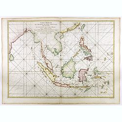
Carte réduite de l'archipel des Indes orientales avec les côtes du continent depuis le golfe de Manar jusqu'à Emoui à la Chine . . .
Important French chart of South East Asia with very good detail on Philippines. Latitude and longitude scales, compass rose and system of rhumb lines, soundings near coas...
Place & Date: Paris, 1745
Selling price: $3000
Sold in 2017

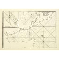
Nouvelle carte des mers comprises entre le détroit de Banca et P°. Timon avec la partie orientale du détroit de Malacca.
Important French chart of the tip of Malaysia with Singapore. Latitude and longitude scales, compass rose and system of rhumb lines, soundings near coast and in bay areas...
Place & Date: Paris, 1745

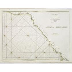
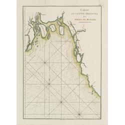
Carte particulière de la côte d'Afrique depuis le cap des Courans jusqu'à la baye de Ste Hélène. . .
Large and detailed sea chart of South Africa.Engraved by Guillaume-Nicolas Delahaye (1727-1802).Latitude and longitude scales, compass rose and system of rhumb lines, sou...
Place & Date: Paris, 1745

Plan du Cap de Bonne-Esperance et ses environs..
Large and detailed sea chart of the Cape of Good Hope from Saldahna Bay to False Bay.Engraved by Guillaume-Nicolas Delahaye (1727-1802).Latitude and longitude scales, com...
Place & Date: Paris, 1745
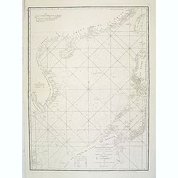
![Carte de la coste orientale de la Chine depuis Amoy, jusqu'à Chusan avec une partie de l'Isle Formose [with] Plan du port d'Amoy ou Emouy.](/uploads/cache/33583-250x250.jpg)
Carte de la coste orientale de la Chine depuis Amoy, jusqu'à Chusan avec une partie de l'Isle Formose [with] Plan du port d'Amoy ou Emouy.
Important French chart of the China Sea with the coast of Northern China, including a large depiction of Formosa.Latitude and longitude scales, compass rose and system of...
Place & Date: Paris, Jean-François Robustel, 1745

Plan de la Rade de Gedda situee de la Cote d'Arabie sur la Mer Rouge.
Chart of the area around city of Gedda in the Red Sea. D'Après De Mannevillette (1707-1780) was one of Franc's first hydrographers. When the first edition of his Atlas L...
- $600 / ≈ €561
Place & Date: Paris, 1745

Carte de la Mer Rouge, depuis Moka jusqu's Gedda. . . .
Chart of the Red Sea. With 3 inset maps of Shake Omare, Goofs and Gedan. D'Après De Mannevillette (1707-1780) was one of France's first hydrographers. When the first edi...
Place & Date: Paris, 1753
Carte de L'entrée du Golfe de la Mer Rouge.
Chart of the Gulf of Aden with the coast line of Yemen, the Island Socotra and the entrance of the Red Sea. With 2 inset charts off-shore of the town Mocha.D'Après De Ma...
- $400 / ≈ €374
Place & Date: Paris, 1753

Carte de la Baye et du Port de Trinquemalay dans L'Isle de Ceylan.
Chart showing the bay of Trincomalee, Ceylon (Sri Lanka). Trincomalee is natural deep water port on the east coast of Sri Lanka, about 110 miles northeast of Kandy. It is...
- $450 / ≈ €421
Place & Date: Paris, 1775

Carte de la Baye et du Port de Trinquemalay Dans L'Isle de Ceylan.
French chart of the harbor of Trinquemalay on the island of Ceylon. Prepared after Samuel Cornish who was a vice admiral for the English East India company.Latitude and l...
- $350 / ≈ €328
Place & Date: Paris, Brest, chez Demonville, 1775
A chart of the China Sea inscribed to Monsr. D'APRES de MANNEVILLETTE .. To A.Dalrymple.
Most important milestone sea chart is based upon the surveys made from navigational surveys by Alexander Dalrymple (1737-1808]. He was the first Hydrographer of the Briti...
Place & Date: Paris, ca. 1775
Carte Orientale de Madacascar Depuis la Rivière Ivondrou jusqu'à Mananzari.
Large sea sea chart of the southeast coastline of Madagascar and four inset maps of the harbors and anchorage of Tamatave, Foulpointe, Teintingue und Veninguebe. Inset ma...
- $125 / ≈ €117
Place & Date: Paris, Brest, chez Demonville, 1775
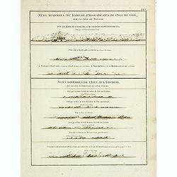
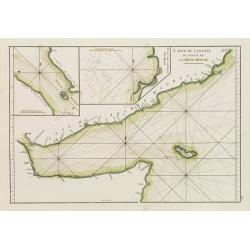
Vues diverses du fort de l'Agouade pres de l'isle de Goa . . . Sumatra . . .
French sea sea chart with 9 coastal views near Goa in India and Sumatra. The titles above the main profiles reading as following : Vues diverses du fort de l'Agouade pre...
- $200 / ≈ €187
Place & Date: Paris, Brest, Demonville, 1775
Carte de la Mer Rouge, depuis Moka jusqu'a Gedda.
Chart of the Red Sea. With 3 inset maps of Shake Omare, Goofs and Gedan.D'Après De Mannevillette (1707-1780) was one of France's first hydrographers. When the first edit...
- $450 / ≈ €421
Place & Date: Paris, 1775
Carte Plate de la partie Septentrionale du Detroit de Malac, depuis de la rade d'Achem jusqu'a Malac.
French chart of the Island of Sumatra and the Malay Peninsula separated by the strait of Malacca in Indonesia.Latitude and longitude scales, compass rose and system of rh...
- $500 / ≈ €468
Place & Date: Paris, ca. 1775
Plan des Isles Querimbo, Oybo, et Matemo / Plan de l'Ile de Patte et de son Port.
French sea chart of Isles Patte, Querimbo, Oybo, Matemo on East coast of Madagascar. Latitude and longitude scales, compass rose and system of rhumb lines, soundings near...
- $75 / ≈ €70
Place & Date: Paris, Brest, chez Demonville, 1775
Carte Plate qui comprend La partie septentrionale de LA Cöte de Coromandel et les Côtes de Golconde , D' Orcha et de Bengale.
French chart of Coromandel in India. West to the top.Latitude and longitude scales, compass rose and system of rhumb lines, soundings near coast and in bay areas.D' Aprè...
- $150 / ≈ €140
Place & Date: Paris, Brest, chez Demonville, 1775
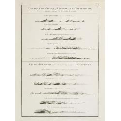
Vues des Cap d'Aden, de St. Antoine, et de Bab-El-Mandeb, sur la Côte Méridionale de l'Arabie Heureuse. Vues de l'Isle de Socotra
Coast profiles near Cape Aden in Yemen and in the lower part coastal profiles near Socotra, an island east of the Horn of Africa and 380 kilometers (240 mi) south of the ...
- $250 / ≈ €234
Place & Date: Paris, Brest, chez Demonville, 1775
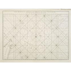
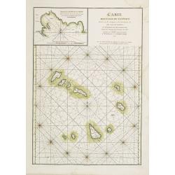
Carte réduite de l'Archipel du Nord-Est de l'Ile Madagascar.
French sea chart of an archipelago off the coast of Madagascar. The northeastern coast of Madagascar is included.Latitude and longitude scales, compass rose and system of...
- $100 / ≈ €94
Place & Date: Paris, Brest, chez Demonville, 1775
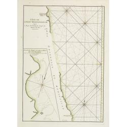
Côte de l'Isle de Madagascar depuis la Baye de Vohemare jusqu'à la pointe de l'Est. Plan du Port et de la Baye du Cap de l'Est.
French chart of the east coast of Madagascar.Latitude and longitude scales, compass rose and system of rhumb lines, soundings near coast and in bay areas.D' Après de Man...
- $100 / ≈ €94
Place & Date: Paris, Brest, chez Demonville, 1775
Carte des Iles du Cap-Verd Dressée sur les remarques et les observations les plus exactes des Navigateurs.
French sea chart of the Cap Verde Islands, situated 570 kilometers off the coast of Western Africa.Latitude and longitude scales, compass rose and system of rhumb lines, ...
- $100 / ≈ €94
Place & Date: Paris, Brest, chez Demonville, 1775

A chart of the China Sea inscribed to Monsr. D'APRES de MANNEVILLETTE .. To A.Dalrymple.
Most important milestone chart is based upon the surveys made from navigational surveys by Alexander Dalrymple (1737-1808]. He was the first hydrographer of the British A...
Place & Date: Paris, ca 1775
Carte de la Côte Orientale du Golfe du Bengale.
French sea chart of coast northeast of India. Latitude and longitude scales, compass rose and system of rhumb lines, soundings near coast and in bay areas.D' Après de Ma...
- $150 / ≈ €140
Place & Date: Paris, ca 1775

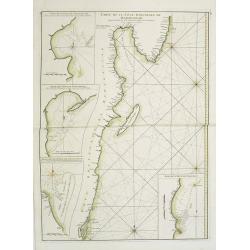
Carte de la Côte de Guzerat, Du Golf de Cambaye et des Côtes de Concan et De Canara.
French sea chart of West India from Gujarat to Mangalore. With inset chart Plan de la Rivière de Surate.Prepared by Jacques-François L'Abbé Dicquemare (1733-1789). La...
Place & Date: Paris, ca 1775
Carte de l'Entrée du Golf de la Mer Rouge. / Plan de La Rade de Moka.
French sea chart of the entry of the Red Sea showing both the African and Arabian coasts. With two inset charts: Plan de La Rade de Moka. and one with the coasts south of...
- $450 / ≈ €421
Place & Date: Paris, ca 1775

Carte réduite de l'Océan Oriental, depuis Le Cap de Bonne Espérance jusqu'à l'Isle Formose.
French chart covering the seas between the Cape of Good Hope until Taiwan and the West Coast of Australia. Prepared by Jacques-François L'Abbé Dicquemare (1733-1789). L...
- $1000 / ≈ €936
Place & Date: Paris, Brest, chez Demonville, 1775

A chart of the northern part of the Indian Ocean..
Chart of the northern part of the Indian Ocean, including part of Arabia, India and Sri Lanka prepared by D'Apré de Mannevillette and published in London by Laurie and W...
- $750 / ≈ €702
Place & Date: London 1794