Subscribe to be notified if similar examples become available.
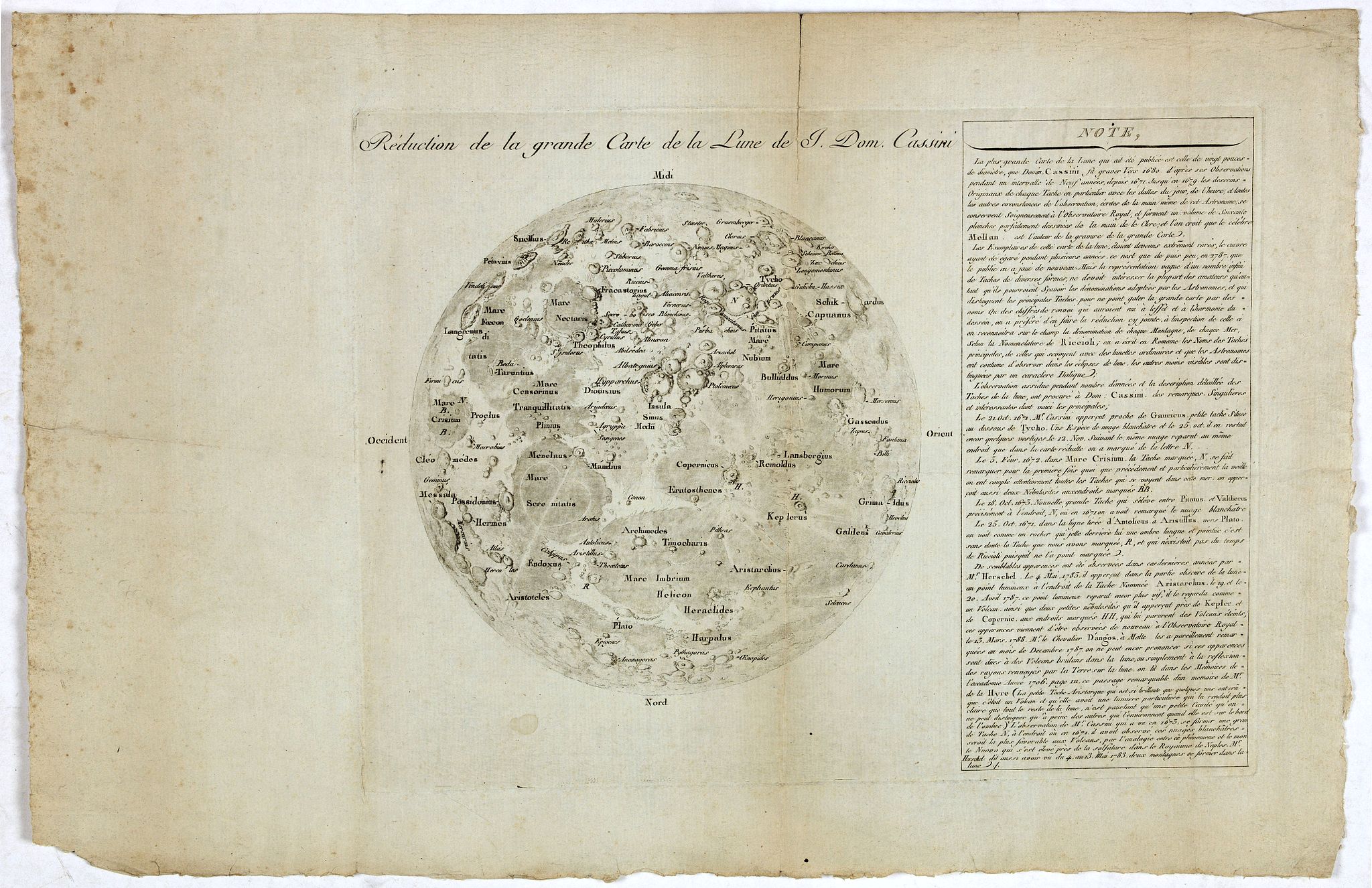
Reduction de la grande Carte de la Lune de J. Dom. Cassini. |
||||||||||||||||||||
|
||||||||||||||||||||
|
|
||||||||||||||||||||
|
Selling price: $ Please login to see price!
Sold in 2019 Missed this item! Add your name to our mailing list and be the first to get notified about our newly added listings. . |
My Collection +
Add this or any of your favorite items in one place. If you want to save the items permanently, you have to sign in or create an account first. |
|||||||||||||||||||
Description
The reduction of Cassini IV's reissue of his great-grandfather's rare and "elegant" lunar map. Jean-Dominique Cassini, known as Cassini IV (1748-1845), was born at the observatory in Paris which his great-grandfather, also called Jean-Dominique Cassini (1625-1712), had founded. The elder Cassini was born in Liguria, and studied at the Panzano Observatory under Giovanni Battista Riccioli and Francesco Maria Grimaldi. In 1669, he moved to France on the invitation of Jean-Baptiste Colbert to help found and become the first director of the new Paris Observatory. Cassini ordered a 34-foot telescope from the great instrument maker Giuseppe Campani for the new observatory, which would prove to be crucial in the creation of his lunar map.
Cassini made approximately 60 drawings of the moon between 1671 and 1679, with the assistance of the artists Sebastien Leclerc and Jean Patigny. The observations took place, when possible, during lunar eclipses, which provided unusual light patterns and a clearer view of the surface. The library of the Paris Observatory retains 57 of these drawings. The copperplate for the map was created from the drawings and engraved by Claude Mellan, who had also engraved Pierre Gassendi's lunar map in 1637. Both the technology and the observations made were so exciting that a manuscript map of lunar features appears in a 1680 painting at Versailles by Henri Testelin, showing Colbert introducing members of the Academy of Sciences to Louis XIV.
The three-dimensional quality given to the lunar features by Patigny and Mellan remained unsurpassed until the advent of photography. It was the first accurate map of the moon, completely "overshadowing" the contributions of Cassini's predecessors, which were highly stylised and lacked interior detail. Contemporary observers commented on their simplicity: Robert Hooke compared the portrayal of the lunar formation Hipparchus by Johannes Johannes Hevelius and Cassini's teacher Riccioli to show the relative paucity of information they provided. Cassini's map, however, shows a level of detail visible only through a telescope of twenty feet in length or longer. The dimensions and positions of the major features are reasonably accurate, but the map's real strength lies in the wealth of verifiable information given on the lunar limb. The moon is oriented to the south, but with the lunar axis rotated about 30-45 degrees clockwise. As well as representing a scientific advance, Cassini's map also staked a claim in a religious dispute. The moon had long been associated with the Virgin Mary, and an analogy drawn between the supposed purity of its surface and her chastity. Observations of the moon from Galileo onwards, however, had shown that the moon's surface was, in fact, far from perfect. It was covered with mountain ranges and pitted with craters. Cassini's map was another firm rebuttal of the theory of the immaculate moon: despite this, Catholic astronomers only gave up the concept at the end of the seventeenth century.
The map has two charming features which are widely supposed to have been included as a reference to the wives of the men involved. In the lower half, on the mountain range Promontorium Heraclides along the Gulf of Rainbows, is a woman's head in profile, with long flowing hair. It is based on a real lunar structure, but is supposed to have been modelled after Cassini's wife, Geneviève de Laistre. Cassini commissioned a pen-and-ink portrait of his wife from Patigny's son the year before the map was published, so the identification may be correct. The other is the marking shaped like the Greek letter phi (f) which appears in the Sea of Serenity. As well as being shaped roughly like a heart, it also begins the Greek word philos, meaning love or affection.
Cassini IV was also an astronomer, and succeeded his father as director of the Paris Observatory in 1784. In 1787, he found the original copperplate of his great-grandfather's lunar map in the Observatory's archive and reissued it. This second edition is identical to the first, aside from the addition of 'Carte de la Lune ... de Jean Dominique Cassini' to the lower edge. Cassini IV also published his own reduced version the following year, the present work (Launay). After the French Revolution in 1789, friction between Cassini IV and the National Assembly caused him to resign his post as Director. The following year he was briefly imprisoned before retiring to Thury, where he lived and worked for the rest of his life.
Cassini IV added labels to significant lunar features on this reduction, as well as a substantial historical note detailing the discoveries made by his great-grandfather and other astronomers. The labels follow the nomenclature of Cassini I's teacher, Giovanni Battista Riccioli, first laid out in his 'Almagestum Movun' in 1651, with much of it still in use today. It divided the visible surface of the Moon into octants, with the features in each named for a certain period of history. Octant VIII contains the names of Riccioli's contemporaries. Famously, the names of Copernicus, Galileo and Kepler appear in the Sea of Storms. Riccioli, a Jesuit scholar, disagreed with their theories of heliocentricity. Interestingly, however, he also credited several Arab astronomers by naming craters after them, despite a tendency in Christian scholars to gloss over their achievements, for example, Azophi and Arzachel (Abd al-Rahman al-Sufi and Al-Zarkali) in the upper portion of the map. (source : Daniel Crouch Rare Books)
Rare. WorldCat records three examples: BNF, ETH-Bibliothek Zurich, Utrecht University Library. One dealer listing at Crouch Rare Books.
References : Albert van Helden, 'The Telescope in the Seventeenth Century', ISIS 65 (1974), Helge Kragh, The Moon that Wasn't (New York: Springer, 2008), Françoise Launay, 'The moon maiden of Cassini's map', Astronomy and Geophysics 44 (2003), Launay, 'La tête de femme de la carte de la lune de Cassini. Une déclaration d'amour', L'Astronomie 117 (2003), Scott L. Montgomery, The Moon and the Western Imagination (Tucson: University of Arizona Press, 1999), Thomas Weimer, 'Carte de la Lune de J.D. Cassini', The Moon and the Planets 20 (1979), pp.163-167, Ewen A. Whitaker, Mapping and Naming the Moon (Cambridge, 2003), Whitaker, 'Selenography in the Seventeenth Century' in R. Taton and C. Wilson (eds.), Planetary Astronomy from the Renaissance to the Rise of Astrophysics (Cambridge: Cambridge University Press, 2003).
FAQ - Guarantee - Shipping
Buying in the BuyNow Gallery
This item is available for immediate purchase when a "Add to Cart" or "Inquire Now" button is shown.
Items are sold in the EU margin scheme
Payments are accepted in Euros or US Dollars.
Authenticity Guarantee
 We provide professional descriptions, condition report (based on 45 years experience in the map business)
Paulus Swaen warrants the authenticity of our items and a certificate of authenticity is provided for each acquired lot.
Condition and Coloring
We indicate the condition of each item and use our unnique HiBCoR grading system in which four key items determine a map's value: Historical Importance, Beauty, Condition/Coloring and Rarity.
Color Key
We offer many maps in their original black and white condition. We do not systematically color-up maps to make them more sellable to the general public or buyer.
Copper engraved or wood block maps are always hand colored. Maps were initially colored for aesthetic reasons and to improve readability. Nowadays, it is becoming a challenge to find maps in their original colors and are therefor more valuable.
We use the following color keys in our catalog:
Original colors; mean that the colors have been applied around the time the map was issued.
Original o/l colors; means the map has only the borders colored at the time of publication.
Colored; If the colors are applied recently or at the end of the 20th century.
Read more about coloring of maps [+]
Shipping fee
A flat shipping fee of $ 30 is added to each shipment by DHL within Europe and North America. This covers : International Priority shipping, Packing and Insurance (up to the invoice amount).
Shipments to Asia are $ 40 and rest of the world $50
We charge only one shipping fee when you have been successful on multiple items or when you want to combine gallery and auction purchases.
Read more about invoicing and shipping
FAQ
Please have a look for more information about buying in the BuyNow gallery
Many answers are likely to find in the general help section.
My Collection+
![]()
With My Collection+ you can collect all your favorite items in one place. It is free, and anyone can create his or her virtual collection.
Unless you are logged in, the item is only saved for this session. You have to be registed and logged-in if you want to save this item permanently to My Collection+.
Read More[+]
Register here, it is free and you do not need a credit card.
Add this item to
My Collection+
or click the following link to see My Collection+.
| Digital Image Download | |
|
Paulus Swaen maintains an archive of most of our high-resolution rare maps, prints, posters and medieval manuscript scans. We make them freely available for download and study. Read more about free image download |
Click the image for a free small image download. |
In accordance with the EU Consumer Rights Directive and habitually reside in the European Union you have the right to cancel the contract for the purchase of a lot, without giving any reason.
The cancellation period will expire 14 calendar days from the day after the date on which you or a third party (other than the carrier and indicated by you) acquires, physical possession of the lot. To exercise the right to cancel you must inform Paulus Swaen Inc, of your decision to cancel this contract by a clear statement (e.g. a letter sent by post, or e-mail.
To meet the cancellation deadline, it is sufficient for you to send your communication concerning your exercise of the right to cancel before the cancellation period has expired.
