Atlas in elephant folio. |
||||||||||||||||||||
|
||||||||||||||||||||
|
|
||||||||||||||||||||
$20000 / ≈ €17471This item is available for immediate sale! Questions before Buying ?
We are happy to answer your questions.
20000.00
|
My Collection +
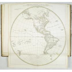
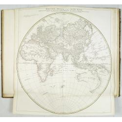
Add this or any of your favorite items in one place. If you want to save the items permanently, you have to sign in or create an account first. |
|||||||||||||||||||
Description
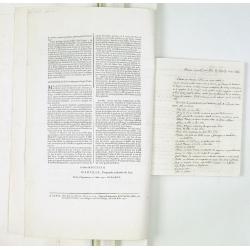
Most of D'Anville's atlases were made up for the individual customer, so no two appear alike. Many of the 59 pages are multi-sheet maps, so the actual map sheet count is maps 1-39 numbered in manuscript, plus four unnumbered maps, This set is accompanied a 4pp. "Mémoire instructif. . . En Mars MDCCXXXII D'Anville, Geographe ordinaire du Roy. Permis d'imprimer ce 21 Mars 1732, Herault" and 4pp. "Mémoire instructif. . ." in pen and brown ink.
Most of d'Anville's atlases were made up for the individual customer, so it appears that no two are alike.
The atlas contains the following maps, extra maps, broad sheet and manuscript note:Ancient world :
1. - Orbis veteribus notus.
2. - Orbis romani pars occidentalis.
3. - Orbis romani pars orientalis.
4. - Gallia antiqua.
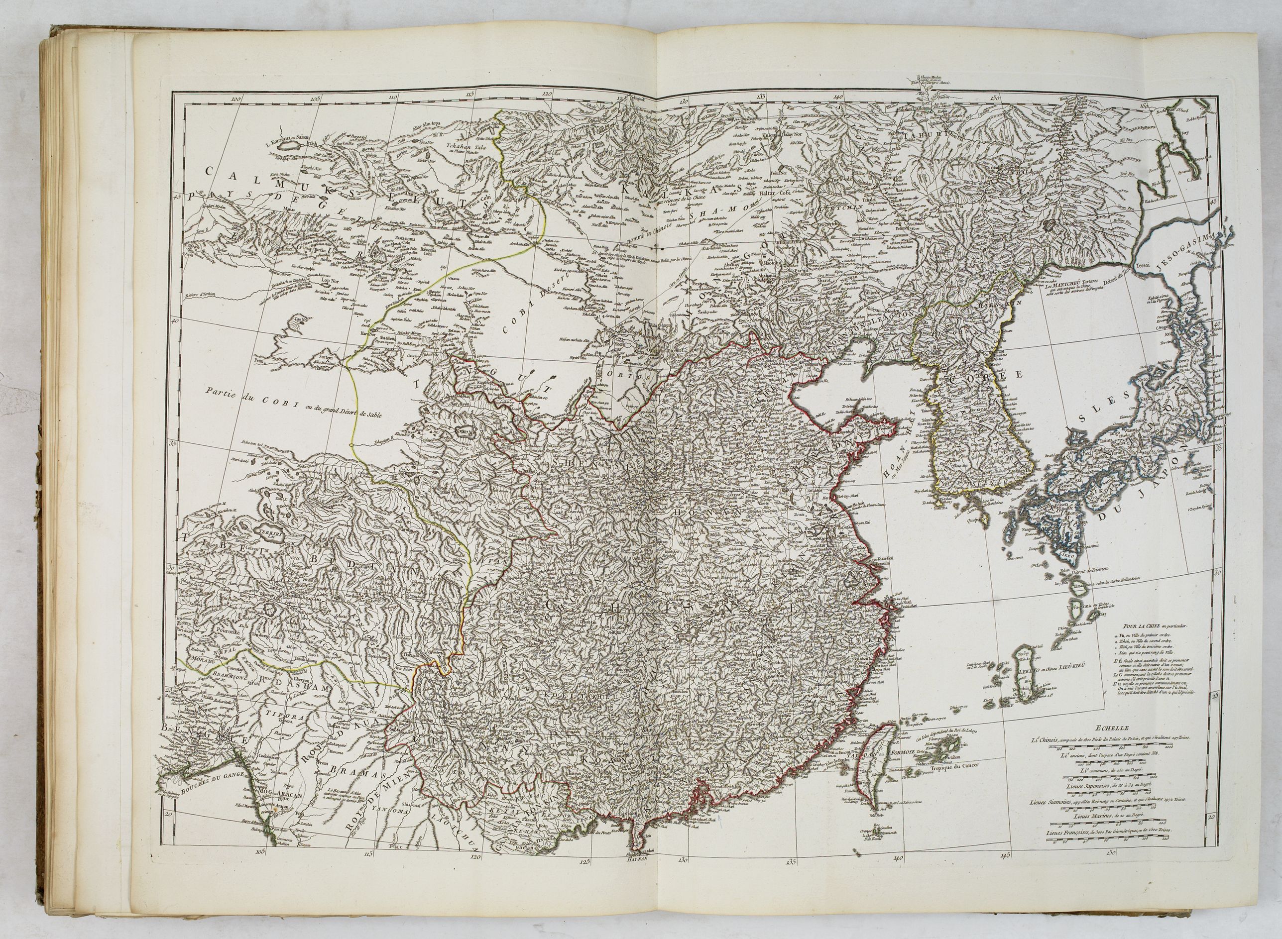
5. - Tabula Italiæ antiquæ geographica.
6. - Græciæ antiquæ specimen geographicum.
7. - Asiæ, quæ vulgo minor dicitur, et Syriæ tabula geographica. (with minor spotting)
8. - La Palestine.
9. - Ad antiquam Indiæ geographiam tabula.
10. - Ægyptus antiqua.
Europe / World map :
11. - Germanie, France, Italie, Espagne, Isles britanniques dans un âge intermédiaire de l'ancienne géographie et de la moderne.
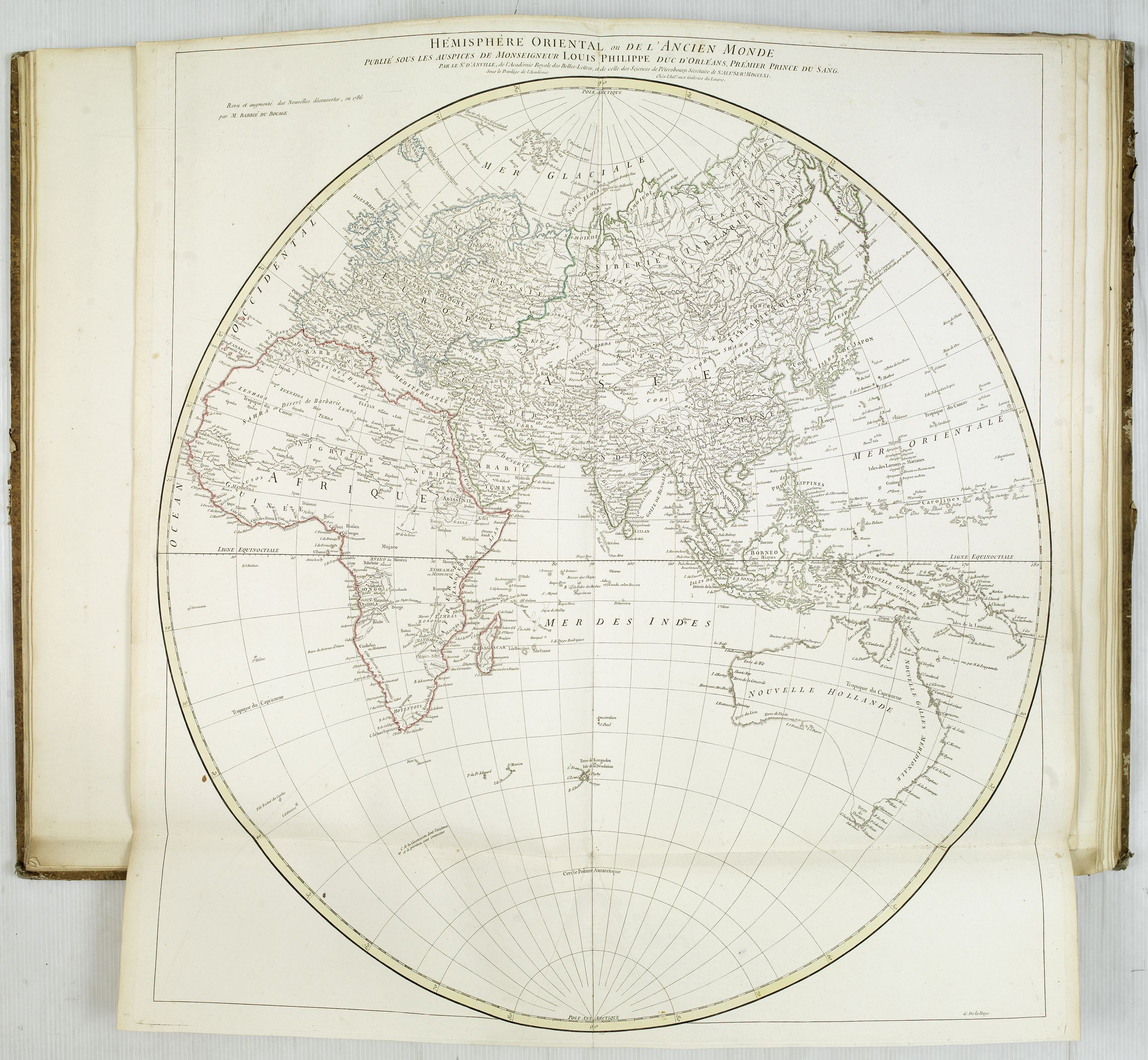
12. - Hémisphère oriental ou de l'Ancien Monde. Revu et augmenté des découvertes, en 1786 par M.Barbié du Bocage. With many updates in Australia.
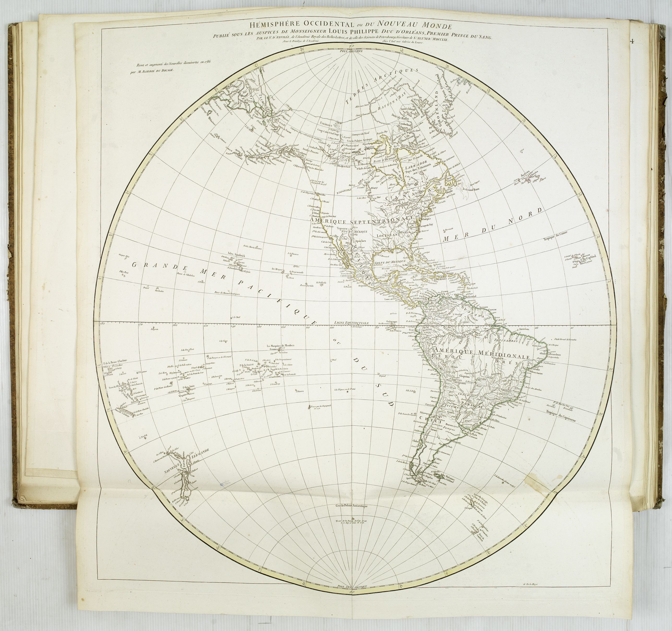
13. - Hémisphère occidental ou du Nouveau Monde. Revu et augmenté des découvertes, en 1786 par M.Barbié du Bocage. With many updates in USA.
14. - Première partie de la carte d'Europe contenant la France,
l'Alemagne, l'Italie, l'Espagne & les isles britanniqs (2-sheet map
of Europe, to be joined with 14a).
14a. - [Première partie de la carte d'Europe contenant la France…] (To be joined with map 14).
15.
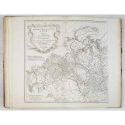
- Seconde partie de la carte d'Europe contenant le Danemark et la
Norwège, la Suède et la Russie. (2-sheet map of Russia and Scandinavia
to be joined with 15a).
15a. - [Seconde partie de la carte d'Europe contenant le Danemark…] (To be joined with map 15).
16.
- Troisième partie de la carte d'Europe contenant le Midi de la Russie,
la Pologne et la Hongrie, la Turquie. (2-sheet map of Central Europe
and Turkey, to be joined with 16a).
16a. - [Troisième partie de la carte d'Europe…] (To be joined with map 16).
17. - La France divisée en provinces et en généralités.
18. - La France divisée en provinces et en généralités.
19. - L'Italie… (2-sheet map of Italy).
19a. - [L'Italie… ] (To be joined with map 19).
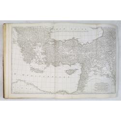
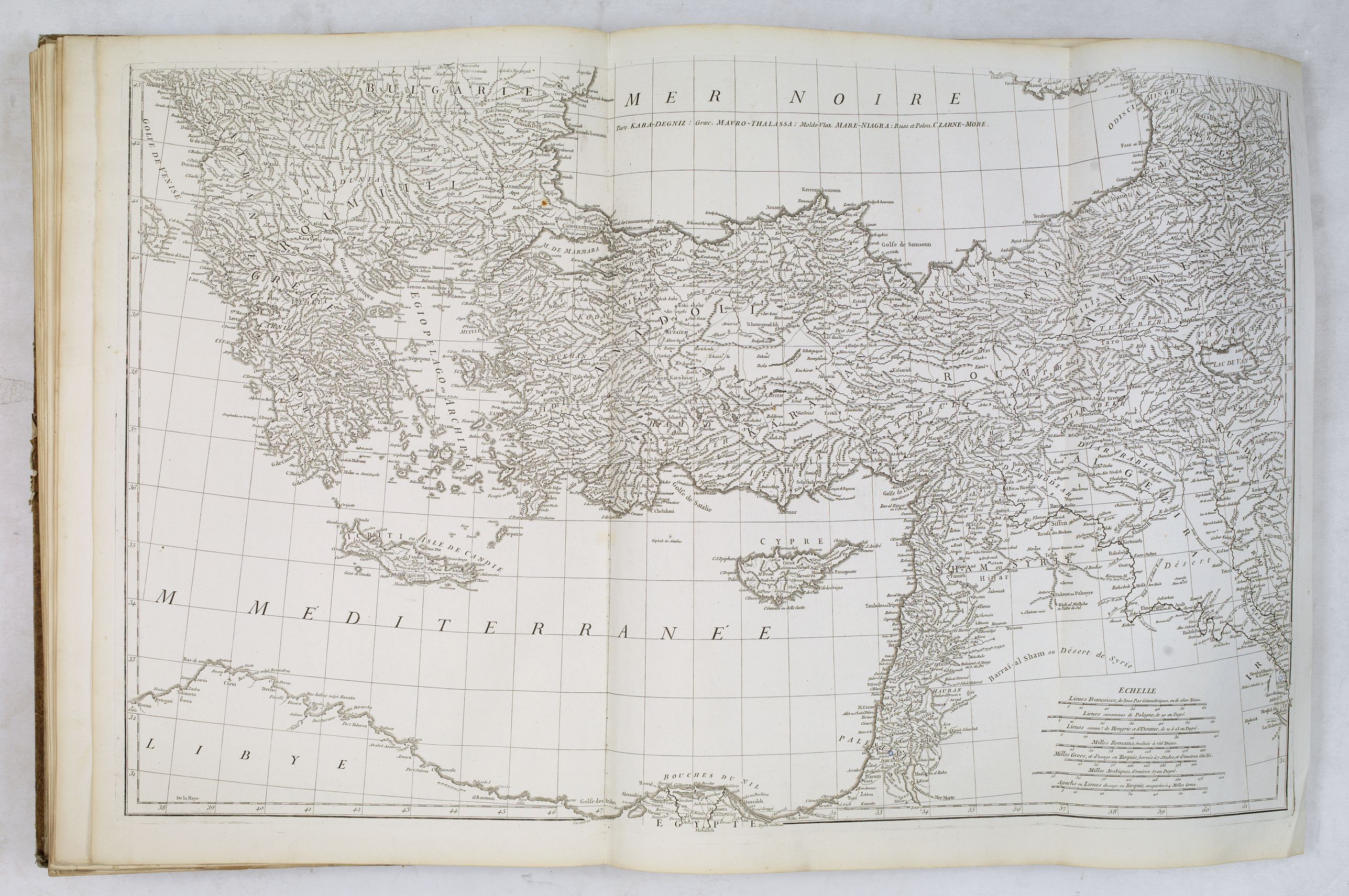
20. - Les Côtes de la Grèce et l'archipel.
Asia :
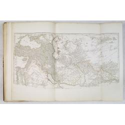
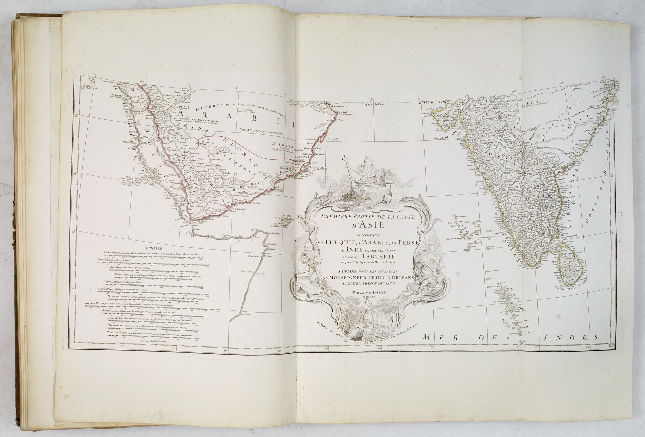
21.
- Première partie de la carte d'Asie contenant la Turquie, l'Arabie, la
Perse, l'Inde en deça du Gange et de la Tartarie (2-sheet map of Near
East, to be joined with 21a).
21a. - [Première partie de la carte d'Asie…] (To be joined with map 21).
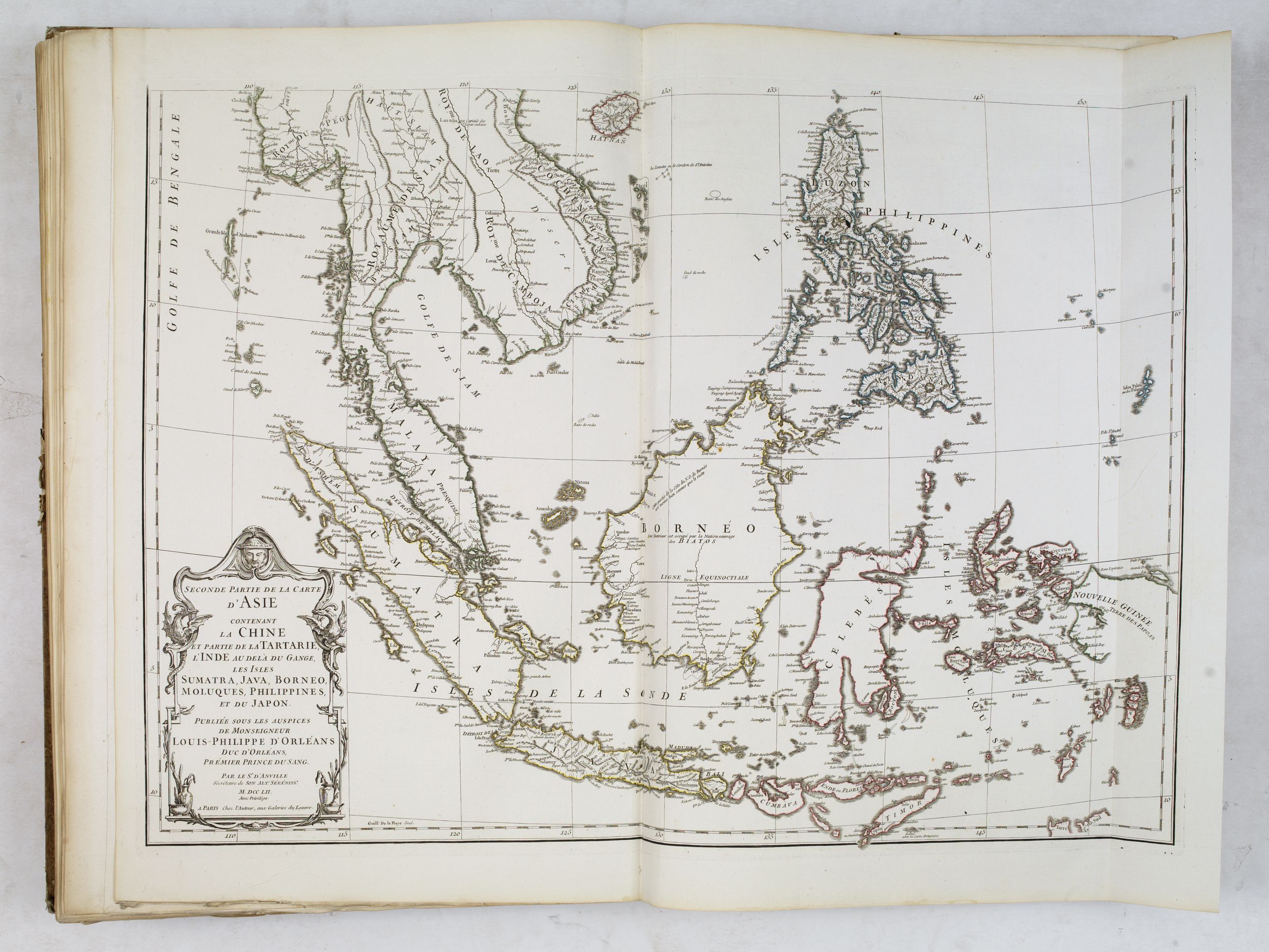
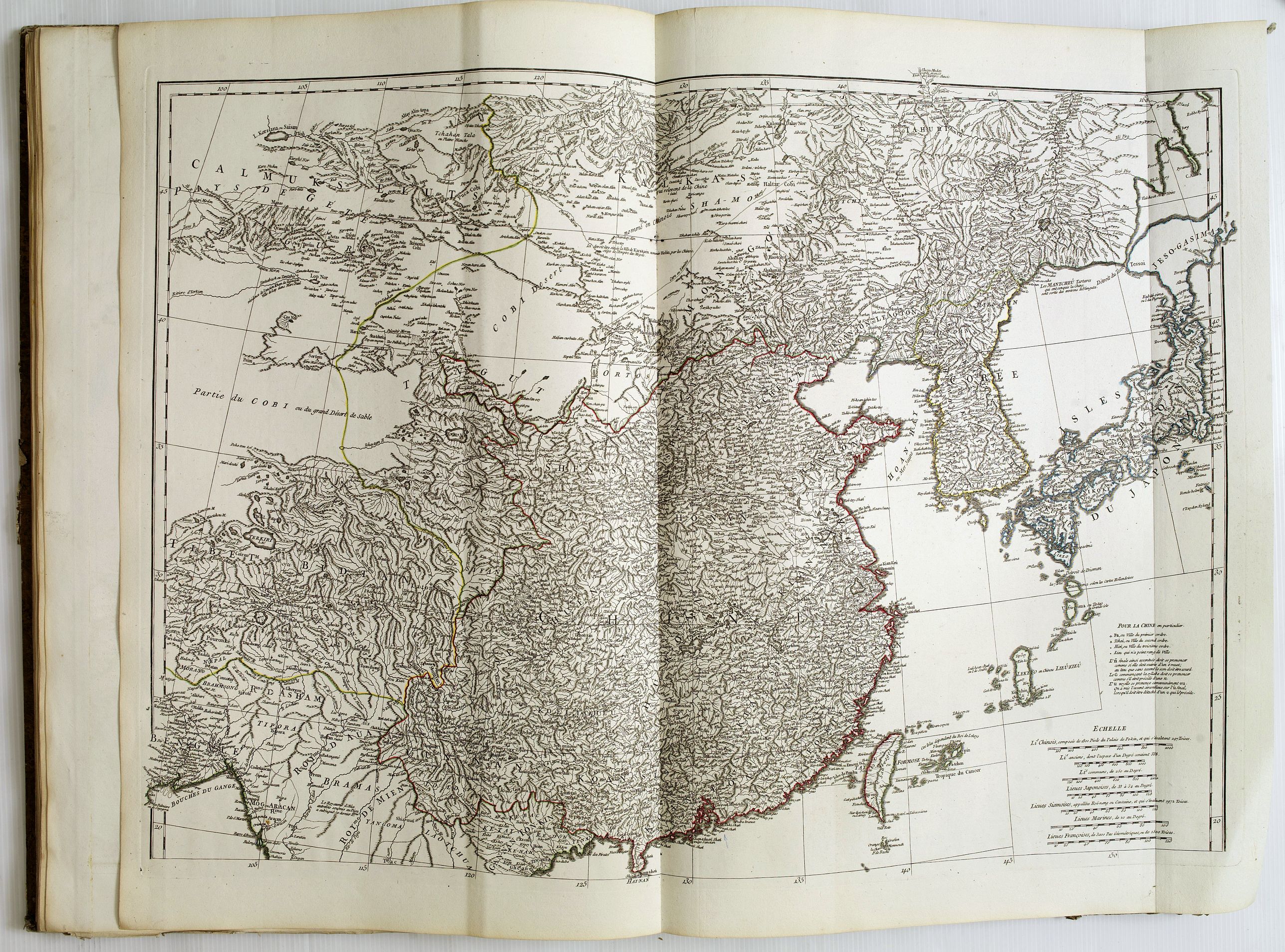
22.
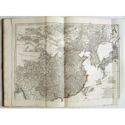
- Seconde partie de la carte d'Asie contenant la Chine et partie de la
Tartarie, l'Inde au-delà du Gange, les Isles Sumatra, Java, Bornéo,
Moluques, Philippines, et du Japon (2-sheet map of the Far East, to be
joined with 22a).
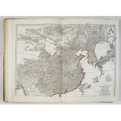
22a. - [Seconde partie de la carte d'Asie…] (To be joined with 22, Showing China, Korea and Japan).
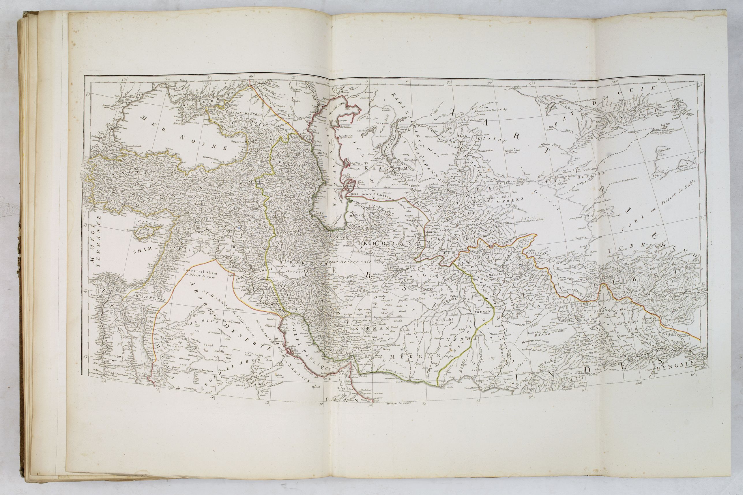
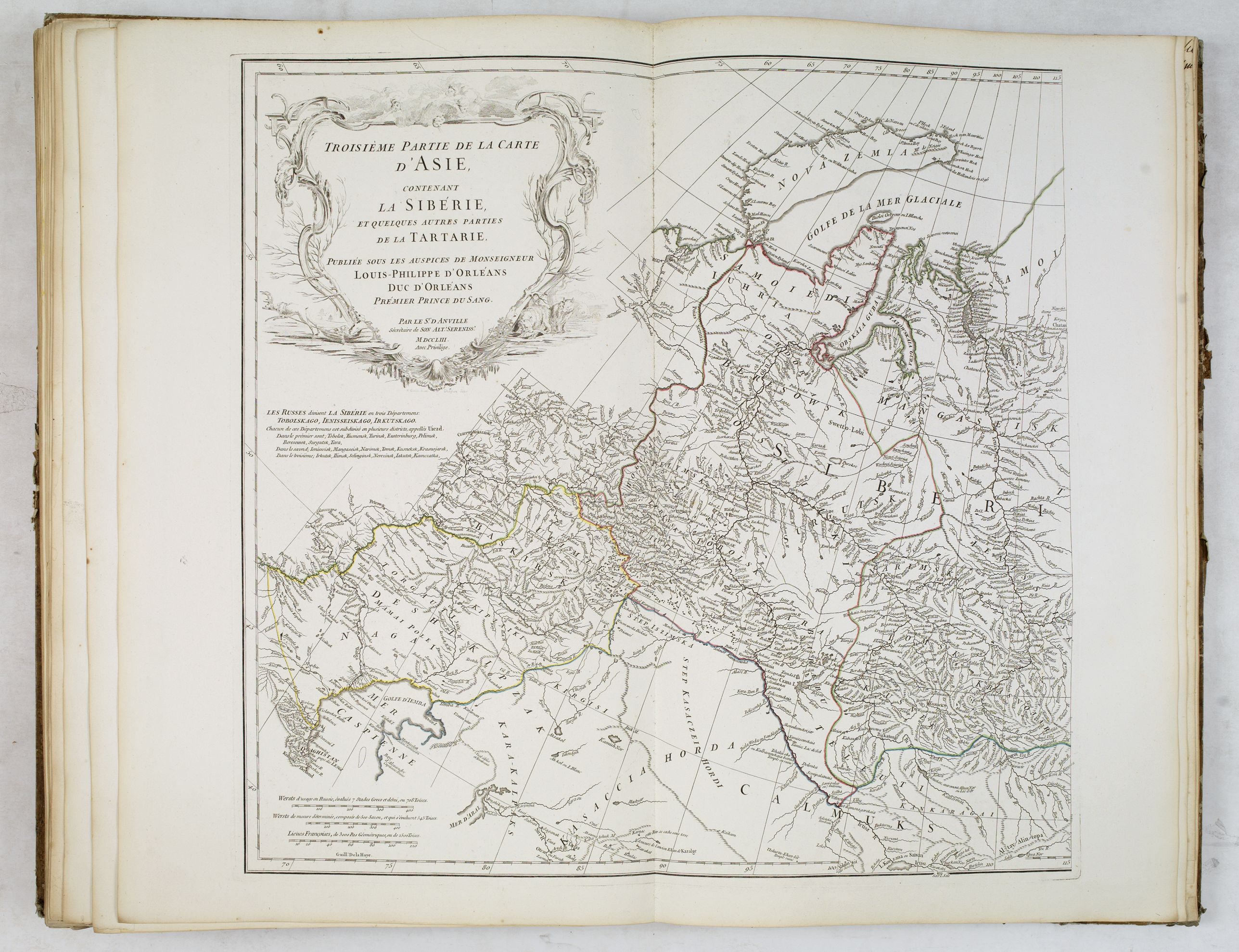
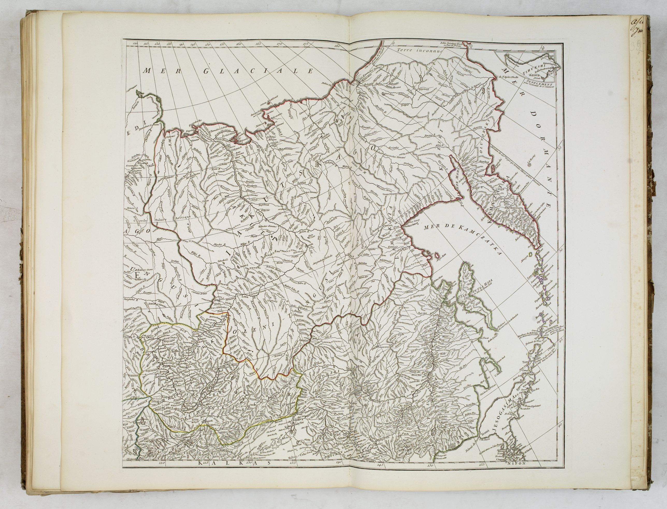
23.
- Troisième partie de la carte d'Asie, contenant la Sibérie, et
quelques autres parties de la Tartarie (2-sheet map of Russia and
Siberia, to be joined with 23a).
23a. - [Troisième partie de la
carte d'Asie,..] (To be joined with 23. Showing Siberia and Kamchatka
and northern tip of Japan).
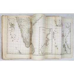
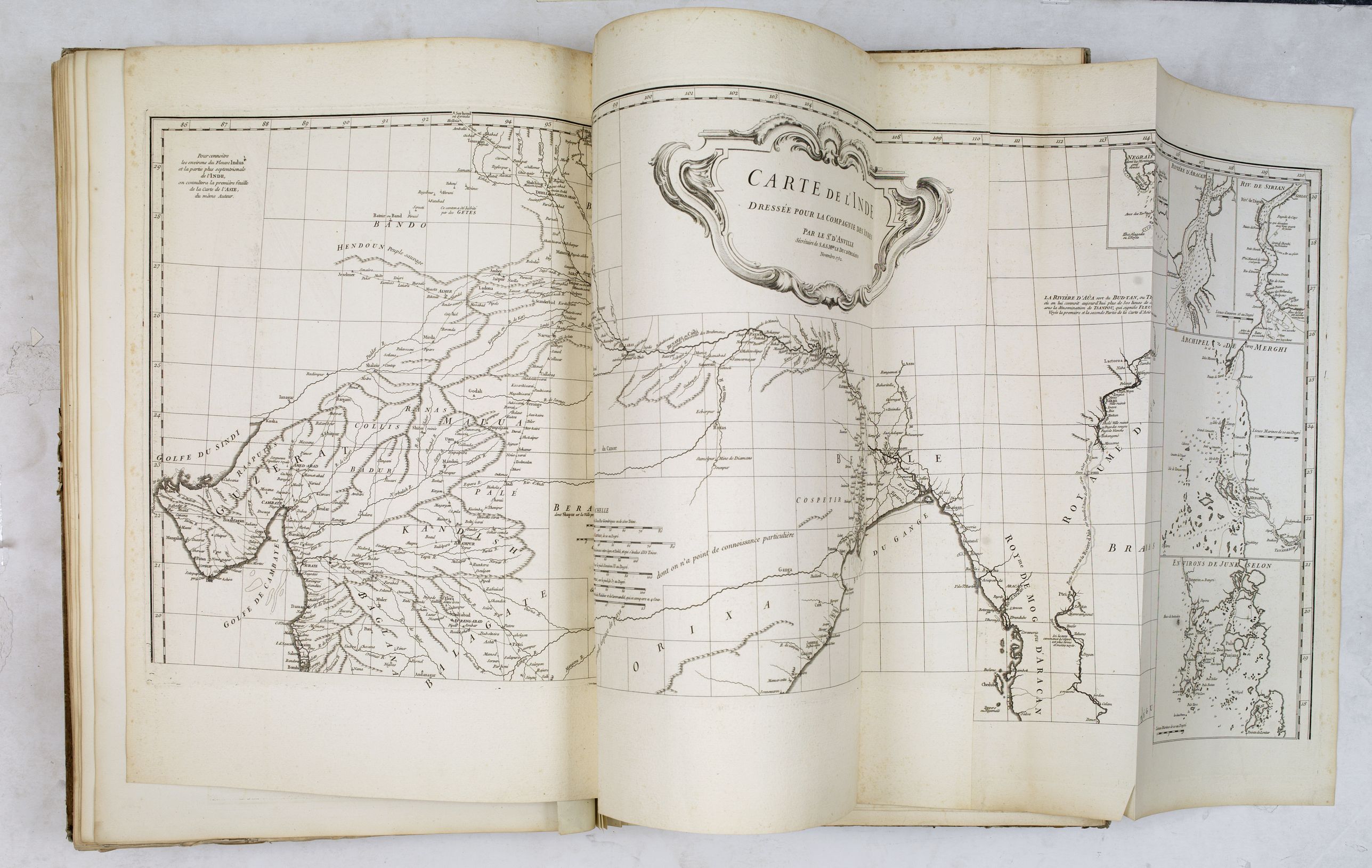
24. - Carte de l'Inde dressée pour la
Compagnie des Indes (4-sheet map of India and Siam. Two joined sheets of
northern India, to be joined with 24a).
24a. - [Carte de l'Inde …] (2 joined steets, to be joined with map 24.).
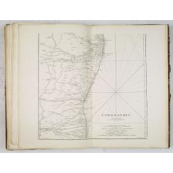
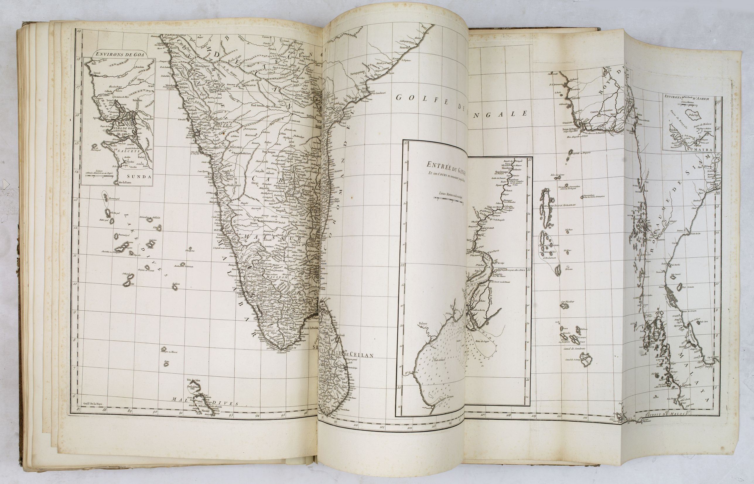
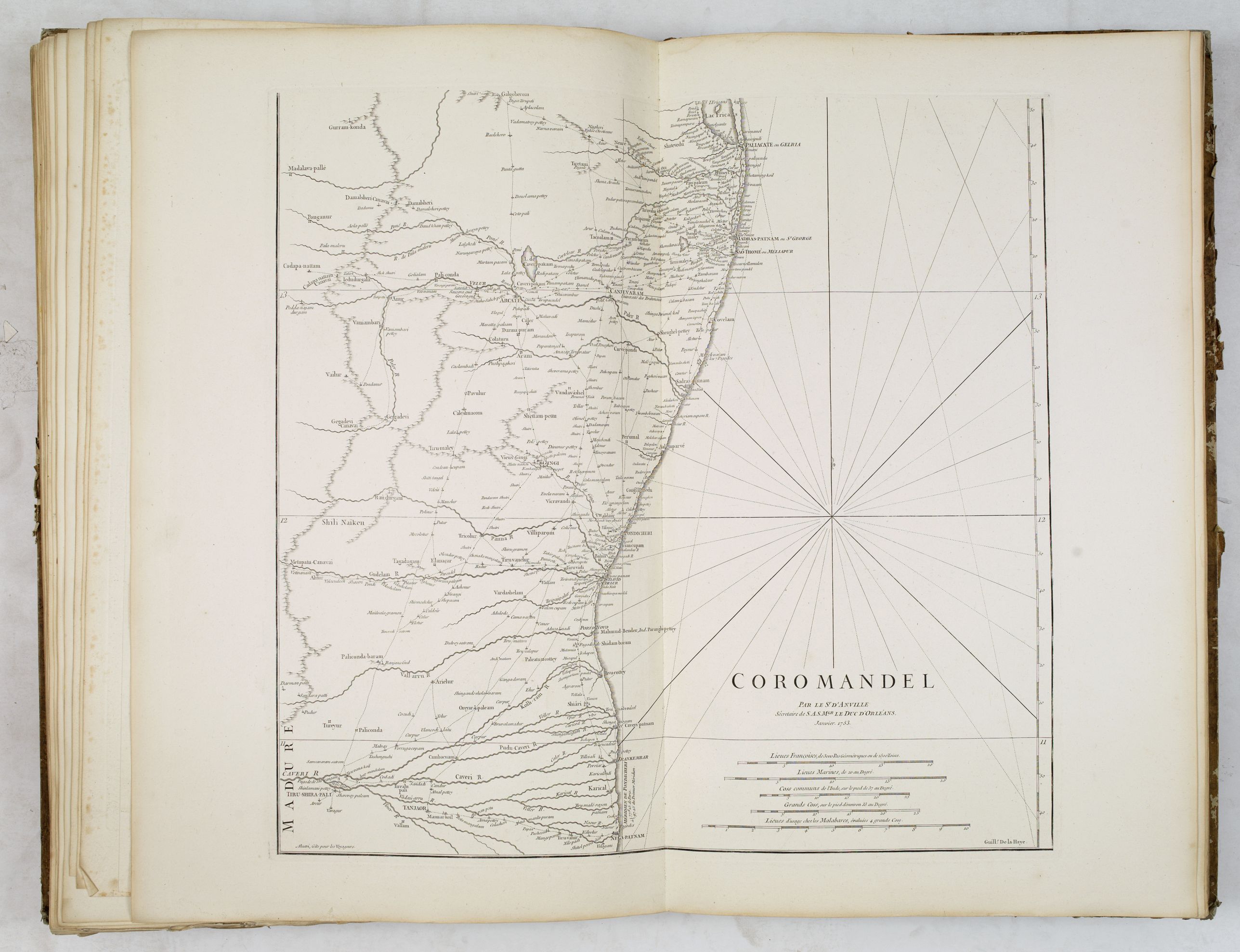
25. - Coromandel (2-sheet map of Coromandel coast, to be joined with map 25a).
25a. - Coromandel. (to bejoined with map 25).
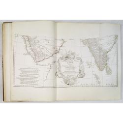
26. - Golfe persique.
27. - Essai d'une nouvelle carte de la mer Caspienne.
28. - Carte de la Phœnicie et des environs de Damas.
29. - L'Euphrate et le Tigre.
30. - Golfe Arabique ou mer Rouge.
Africa :
31. - Afrique (4-sheet map of Africa, 2 joined sheets).
31a. - [Afrique] (2 joined sheets with map 31.)
32. - Égypte nommée dans le pays Missir.
33.
- Carte particulière de la côte occidentale de l'Afrique depuis le cap
Blanc usqu'au cap de Verga, et du cours des rivières de Sénéga et de
Gambie […] dressée pour la Compagnie des Indes (2-sheet map, to be
joined with 33a).
33a. - [Carte particulière de la côte occidentale de l'Afrique… ] (to be joined with map 33).
34. - Guinée entre Sierre-Lione et le passage de la ligne.
America :
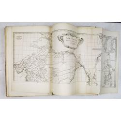
35. - Amérique septentrionale (4-sheet map of North America, 2 joined sheets).
35a. -[ Amérique septentrionale] (2 joined sheets with map 35.)
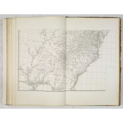
36. - Canada, Louisiane et terres angloises (4-Sheet map of Canada and New England, to be joined with 36a, 36b, 37).
36a. - [Canada, Louisiane et terres angloises]
36b. - [Canada, Louisiane et terres angloises]
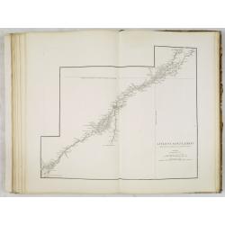
37. - Le Fleuve Saint-Laurent.
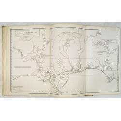
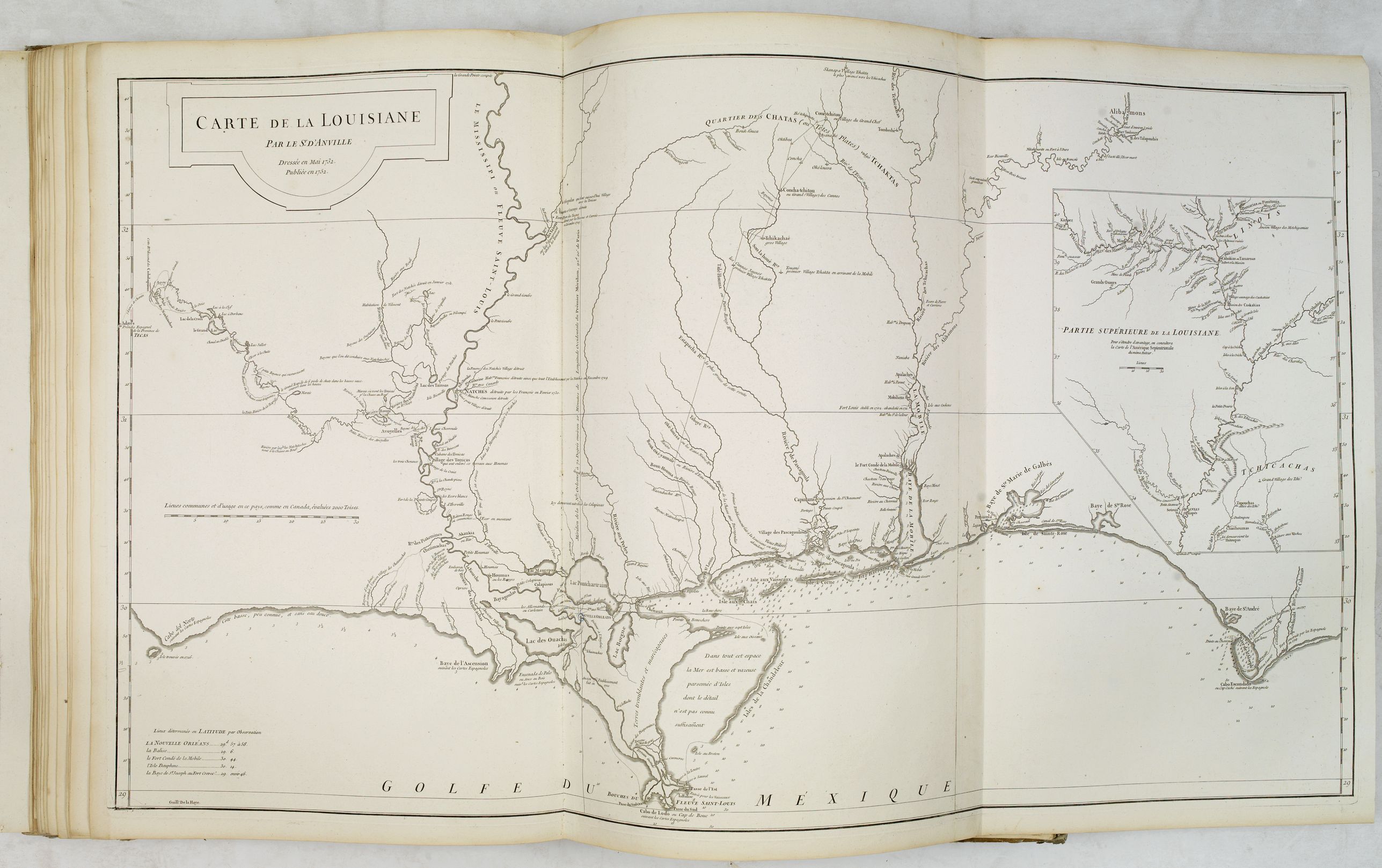
38. - Carte de la Louisiane (2 joined sheets).
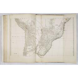
39. - Amérique méridionale ( 6-sheet map of South America, 2 joined sheets).
39a. - [Amérique méridionale] (2 joined sheets with 39 and 39b).
39b. - [Amérique méridionale] (2 joined sheets with 39 and 39a).
Bound with :
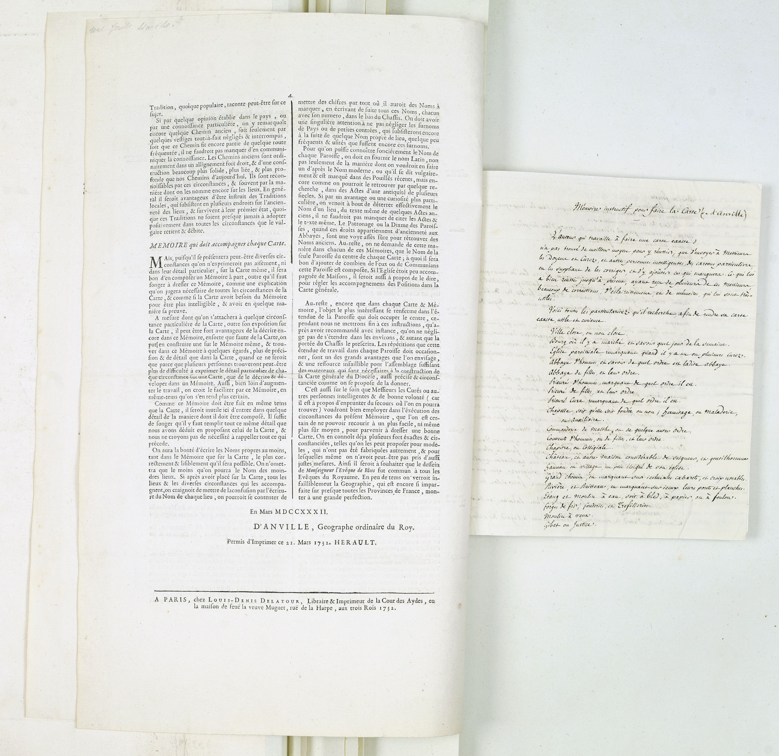
(40) - Printed letter press by d'Anville, Mémoire
instructif pour que dans toutes les paroisses d'un diocèse, il soit
dressé en meme-tems uniformément, par une mèthode aisée à pratiquer, des
cartes & des mémoires particuliers, qui puissent fournir un détail
suffisant pour la carte générale de ce diocése ou d'une province. A Paris, chez Louis-Denis Delatour, 1732. 4 pp. in-folio.
(41) - Anonymous manuscript in brown ink : Mémoire instructif pour faire la carte (de d'Anville). No date. 4 pp. in-4. Detailed description about how to draw a map.
(42) - Double page circulair projection with orientations and topographical icons and signs.
(43) - Carte topographique du diocèse de Lizieux.
(44) - Position des points discutés dans l'analyse géographique de l'Italie par le sr d'Anville.
(45)
- Parallèle du contour de l'Italie selon les cartes de MM. De l'Isle et
Sanson, et celle qui résulte de l'Analyse géographique de ce continent
par le s. d'Anville.
D'Anville's maps have a clarity and directness that is very "modern." He read widely, and incorporated the best available geographic knowledge into his work. The English and others copied from his maps extensively.
One of the most celebrated of French geographers » (Tooley, Maps and map makers, p. 43).
D'Anville is very important for Korean cartography as he made the cartography of Korea widely available. Jean-Baptiste Regis (1664-1738), produced a map that came out in the Kangxi atlas and was used and edited by d'Anville and published in 1735 in du Halde (description de la Chine) and as "Royaume de Coree" (atlas de la Chine 1737). Despite the broadening of the southern part of the peninsula, this map was in the main accurate and was widely copied in the next 150 years (McCune 1977). We will call this shape AND the mentioning of Quelpaert AND Fung-ma as two separate islands the Anville type.
Jean Baptiste Bourguignon d'Anville (1697-1782) engraved his first map at the age of fifteen and produced many maps of high quality throughout his career. He became the finest cartographer of his time and carried on the French school of cartography developed by the Sanson and the de L'Isle families. Although he apparently never left the city of Paris, he had access to the reports and maps of French explorers, traders, and missionaries.
In his Tartariae Sinensis, which was first printed in 1732, d'Anville
showed Korea fairly accurately, though it becomes clear that he had used
Korean sources for the first time. During his long career he accumulated a large collection of cartographic materials that has been preserved. He was particularly interested in Asia and produced the first reasonably accurate map of China in 1735. He became Royal Geographer and Cartographer to the King of France in the middle of the eighteenth century, at a time when French cartography was still considered to be the best in the world.
He was the successor to Guillaume Delisle as the chief proponent of scientific cartography, and his influence on his contemporaries was profound. D'Anville was the finest cartographer of his time, "his attention to detail was exemplary, his maps having a great delicacy of engraving" (Tooley).
The maps are copper engravings with original outline color; most are double pages, some folding, multi-sheet maps. The maps are engraved by Gravelot.
Jean Baptiste Bourguignon d'Anville was perhaps the most important and prolific cartographer of the 18th century.He engraved his first map at the age of fifteen and produced many maps of high quality throughout his career. He became the finest cartographer of his time and carried on the French school of cartography developed by the Sanson and the de L'Isle families.
Although he apparently never left the city of Paris, he had access to the reports and maps of French explorers, traders, and missionaries. During his long career he accumulated a large collection of cartographic materials that has been preserved. He was particularly interested in Asia and produced the first reasonably accurate map of China in 1735.
He became Royal Geographer and Cartographer to the King of France in the middle of the eighteenth century, at a time when French cartography was still considered to be the best in the world.
He was the successor to Guillaume Delisle as the chief proponent of scientific cartography, and his influence on his contemporaries was profound. To illustrate the cartography of the middle to the latter part of the eighteenth century a d'Anville map is essential. He was foremost in using the latest and most accurate cartographic information available. From the latest discoveries of the many French explorers to information available from explorers such as Cook and others. And unlike many cartographers of the day, he was not averse to leaving blank spaces in his maps where knowledge was insufficient.
R.V. Tooley write : "D'Anville was the finest cartographer of his time, his attention to detail was exemplary, his maps having a great delicacy of engraving".
Thomas Basset and Philip Porter write: "It was because of D'Anville's resolve to depict only those features which could be proven to be true that his maps are often said to represent a scientific reformation in cartography." (The Journal of African History, Vol. 32, No. 3 (1991), pp. 367-413).
D'Anville and Thomas Jefferson
D'Anville's maps draw on material gathered from several French expeditions made during the first half of the eighteenth century. At this time, the French were intent on finding a trade route to the western Indians and to Santa Fe and also on preempting Spanish expansion into the Mississippi River valleys.
Around 1720, Jean Baptiste Bénard de La Harpe undertook two expeditions to explore the Red and Arkansas Rivers and part of what is now Oklahoma. At roughly the same time, Claude-Charles du Tisné journeyed by land to the source of the Osage River and explored southeastern Kansas.
It is known that Thomas Jefferson acquired seven maps by d'Anville in 1787. Although the titles of the maps he acquired are not known, Jefferson must have been familiar with d'Anville's maps of North America, including "Carte de la Louisiane."
In a letter to Secretary of the Treasury Albert Gallatin relating to a newly commissioned map of North America, Jefferson discussed the use of d'Anville as a reference for the lower Mississippi basin.
Meriwether Lewis obtained a copy before the Lewis and Clark Expedition.
D'Anville's map "Carte de la Louisiane shows the Gulf Coast from the Tallahassee area to around the mouth of the Sabine in Texas, one of the best obtainable large format maps of the region from this period. The map tracks the Mississippi, Arkansas, Red, Osage and Missouri Rivers, and includes an excellent large inset of the Mississippi River Valley from the Arkansas to above the Missouri Rivers.
Most of the information was derived from Valentin Devin, who arrived in Pensacola in 1719 (under the auspices of John Law's Company of the West) and began producing highly regarded maps immediately upon his arrival on the Gulf Coast, until expelled by the Spanish after a three-year struggle. Devin used his information and materials gathered from Le Maire and others to produce a number of manuscript maps which were sent back to France and resulted in a series of maps by De L'Isle, Buache and finally d'Anville, whose maps of the Gulf Coast formed the standard for several years.
D'Anville's two-sheet map "Amerique Septentrionale". Publiee sous les auspices de Monseigneur le Duc d'Orleans, Premier Prince du Sang. Par le Sr. d'Anville, M DCC XLVI" depicts a "Grande Riviére" running to the west out of the "Lac des Bois" with a note that it was discovered by an Indian named Ochagac, or Ochagach, a reference to the accounts of La Vérendrye and his sons. The map labels the upper Missouri the "Pekitanoui R." Only the upper half of "Amérique Septentrionale" is exhibited. Shows boundaries of Treaty of 1763 and Ft. Duquesne.
References : Wagner, 552; Lowery, 382; Taliaferro, 134; Checklist of printed maps of the Middle West to 1900, 1-0598; Karpinski, LVIII; Tooley, Printed maps of America, 104; cf P571, 572, 599; NMM 200.
China and Korea
Jean Baptiste Bourguignon d’Anville beautifully printed and splendidly illustrated "Nouvel atlas de la Chine, de la Tartarie chinoise, et du Thibet" is the summation of European knowledge on China in the 18th-century. It was begun by the Jesuit missionaries to China in 1708, and their completed manuscripts were presented to the Emperor Kang-hi in 1718. Kang-hi ordered further surveys and from them were constructed the well-known maps forwarded to father Du Halde and used by d'Anville for this Du Haldes "Description … de l'empire de la Chine et de la Tartarie chinoise" (1736) and his Atlas (1737).
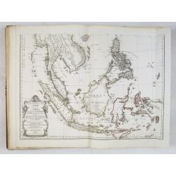
This atlas contains a very detailed two-sheet map of the Far East (map 22 and 22a) including China, Korea and Japan.
The map is dated 1752 and it becomes clear that he has incorporated the sources for of his "Nouvel atlas de la Chine".
Atlas in elephant folio (book block measuring 580x375 mm.), bound in contemp. half calf with gilted label on spine "ATLAS DE D'ANVILLE", 59 pages multi-sheet maps, actual map sheet count is 42. Maps dated 1743-1786. This set is accompanied by a 4 pages printed broadsheet "Mémoire instructif. . . En Mars MDCCXXXII D'Anville, Geographe ordinaire du Roy. Permis d'imprimer ce 21 Mars 1732, Herault" and 4 pages manuscript text in pen and brown ink "Mémoire instructif pour faire la carte (de d'Anville)..."
Very good condition inside the book block, the two sheet map of Africa has slight overall browning, the others printed on fine white thick paper and colored in outline.
The maps are copper engravings with original outline color; most are double pages, some folding, multi sheet maps. The first 39 maps have a number 1-39 in brown ink in a contemporary hand-on verso.
The cartouches on many of the maps are designed by his brother, Hubert-François Bourguignon, commonly known as Gravelot (26 March 1699 — 20 April 1773). Gravelot was a engraver, a famous book illustrator, designer and drawing-master. Born in Paris, he emigrated to London in 1732, where he quickly became a central figure in the introduction of the Rococo style in British design, which was disseminated from London in this period through the media of book illustrations and engraved designs as well as by the examples of luxury goods in the "French taste" brought down from London to provincial towns and country houses. The maps are engraved by the master engravers Guillaume De la Haye, Major, Delafosse.
Jean Denis Barbie Du Bocage (1760-1825)
Studied at the Mazarin College in Paris and became in 1777 the only pupil of Jean-Baptiste Bourguignon d'Anville.
In
1780, aged 20, he worked for the French Ministry of Foreign Affairs
and, from 1785 he worked for the library of "Cabinet des médailles de la
Bibliothéque du roi" and moved in 1792 to the Geography department in
the same part of the same library.
Since 1797 a member of "du
conseil de géographie du bureau du cadastre du ministère de l'intérieur"
and in 1802 he was responsible of various geographical works, among a
map of the Morea (Peloponnese) for the Ministry of War. From 1803 to
1809, he was a geographer at the Ministry of Foreign Affairs and became
the first professor of geography at the Faculty of Arts of Paris from
1809 to 1825.
He gathered a large collection of maps and geographic documents, his library was sold after his death in February 1850.
Being
a pupil of d'Anville, it was clear that Jean Denis Barbie Du Bocage was
asked to update the d'Anville maps after the Treaty of Paris (1783).
The very large two-sheet double hemisphere world map (over 3ft, 1m) who
was engraved by Guillaume Nicolas Delahaye in 1761 is heavenly updated
to 1786. The states of "Virginie", "Caroline" are removed and replaced
by "ETATS-UNIS". Alaska, Cape Cod, Savanah, S.Paul and the discoveries
of Captain Cook, including an early appearance of the Sandwich Islands
(Hawaii) are now added to the plate. The latest discoveries by Cook in
NW of America are also included. Bocage has included nearly all Cook's
detail of New Zealand.
In the western hemisphere, especially Australia, has many place names added.
The atlas contains the following maps, extra maps, broad sheet and manuscript note:
Ancient world :
1. - Orbis veteribus notus.
2. - Orbis romani pars occidentalis.
3. - Orbis romani pars orientalis.
4. - Gallia antiqua.
5. - Tabula Italiæ antiquæ geographica.
6. - Græciæ antiquæ specimen geographicum.
7. - Asiæ, quæ vulgo minor dicitur, et Syriæ tabula geographica. (with minor spotting)
8. - La Palestine.
9. - Ad antiquam Indiæ geographiam tabula.
10. - Ægyptus antiqua.
Europe / World map :
11. - Germanie, France, Italie, Espagne, Isles britanniques dans un âge intermédiaire de l'ancienne géographie et de la moderne.
12. - Hémisphère oriental ou de l'Ancien Monde. Revu et augmenté des découvertes, en 1786 par M.Barbié du Bocage. With many updates in Australia.
13. - Hémisphère occidental ou du Nouveau Monde. Revu et augmenté des découvertes, en 1786 par M.Barbié du Bocage. With many updates in USA.
14. - Première partie de la carte d'Europe contenant la France,
l'Alemagne, l'Italie, l'Espagne & les isles britanniqs (2-sheet map
of Europe, to be joined with 14a).
14a. - [Première partie de la carte d'Europe contenant la France…] (To be joined with map 14).
15.
- Seconde partie de la carte d'Europe contenant le Danemark et la
Norwège, la Suède et la Russie. (2-sheet map of Russia and Scandinavia
to be joined with 15a).
15a. - [Seconde partie de la carte d'Europe contenant le Danemark…] (To be joined with map 15).
16.
- Troisième partie de la carte d'Europe contenant le Midi de la Russie,
la Pologne et la Hongrie, la Turquie. (2-sheet map of Central Europe
and Turkey, to be joined with 16a).
16a. - [Troisième partie de la carte d'Europe…] (To be joined with map 16).
17. - La France divisée en provinces et en généralités.
18. - La France divisée en provinces et en généralités.
19. - L'Italie… (2-sheet map of Italy).
19a. - [L'Italie… ] (To be joined with map 19).
20. - Les Côtes de la Grèce et l'archipel.
Asia :
21.
- Première partie de la carte d'Asie contenant la Turquie, l'Arabie, la
Perse, l'Inde en deça du Gange et de la Tartarie (2-sheet map of Near
East, to be joined with 21a).
21a. - [Première partie de la carte d'Asie…] (To be joined with map 21).
22.
- Seconde partie de la carte d'Asie contenant la Chine et partie de la
Tartarie, l'Inde au-delà du Gange, les Isles Sumatra, Java, Bornéo,
Moluques, Philippines, et du Japon (2-sheet map of the Far East, to be
joined with 22a).
22a. - [Seconde partie de la carte d'Asie…] (To be joined with 22, Showing China, Korea and Japan).
23.
- Troisième partie de la carte d'Asie, contenant la Sibérie, et
quelques autres parties de la Tartarie (2-sheet map of Russia and
Siberia, to be joined with 23a).
23a. - [Troisième partie de la
carte d'Asie,..] (To be joined with 23. Showing Siberia and Kamchatka
and northern tip of Japan).
24. - Carte de l'Inde dressée pour la
Compagnie des Indes (4-sheet map of India and Siam. Two joined sheets of
northern India, to be joined with 24a).
24a. - [Carte de l'Inde …] (2 joined steets, to be joined with map 24.).
25. - Coromandel (2-sheet map of Coromandel coast, to be joined with map 25a).
25a. - Coromandel. (to bejoined with map 25).
26. - Golfe persique.
27. - Essai d'une nouvelle carte de la mer Caspienne.
28. - Carte de la Phœnicie et des environs de Damas.
29. - L'Euphrate et le Tigre.
30. - Golfe Arabique ou mer Rouge.
Africa :
31. - Afrique (4-sheet map of Africa, 2 joined sheets).
31a. - [Afrique] (2 joined sheets with map 31.)
32. - Égypte nommée dans le pays Missir.
33.
- Carte particulière de la côte occidentale de l'Afrique depuis le cap
Blanc usqu'au cap de Verga, et du cours des rivières de Sénéga et de
Gambie […] dressée pour la Compagnie des Indes (2-sheet map, to be
joined with 33a).
33a. - [Carte particulière de la côte occidentale de l'Afrique… ] (to be joined with map 33).
34. - Guinée entre Sierre-Lione et le passage de la ligne.
America :
35. - Amérique septentrionale (4-sheet map of North America, 2 joined sheets).
35a. -[ Amérique septentrionale] (2 joined sheets with map 35.)
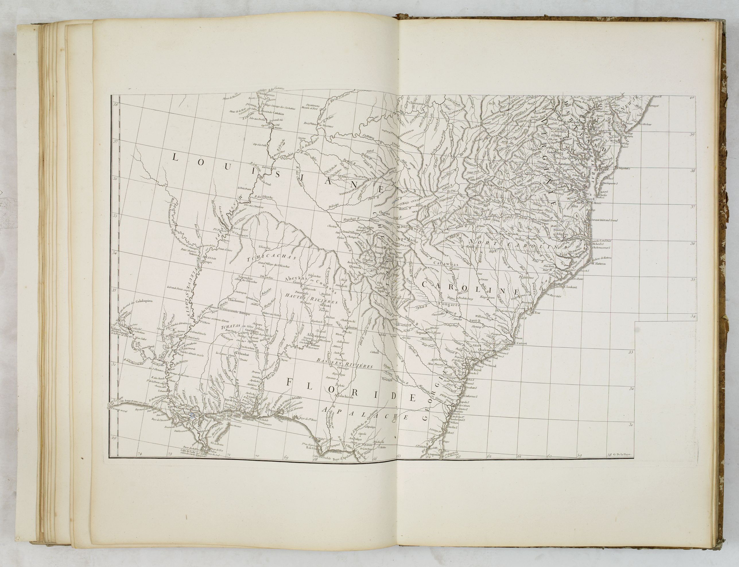
36. - Canada, Louisiane et terres angloises (4-Sheet map of Canada and New England, to be joined with 36a, 36b, 37).
36a. - [Canada, Louisiane et terres angloises]
36b. - [Canada, Louisiane et terres angloises]
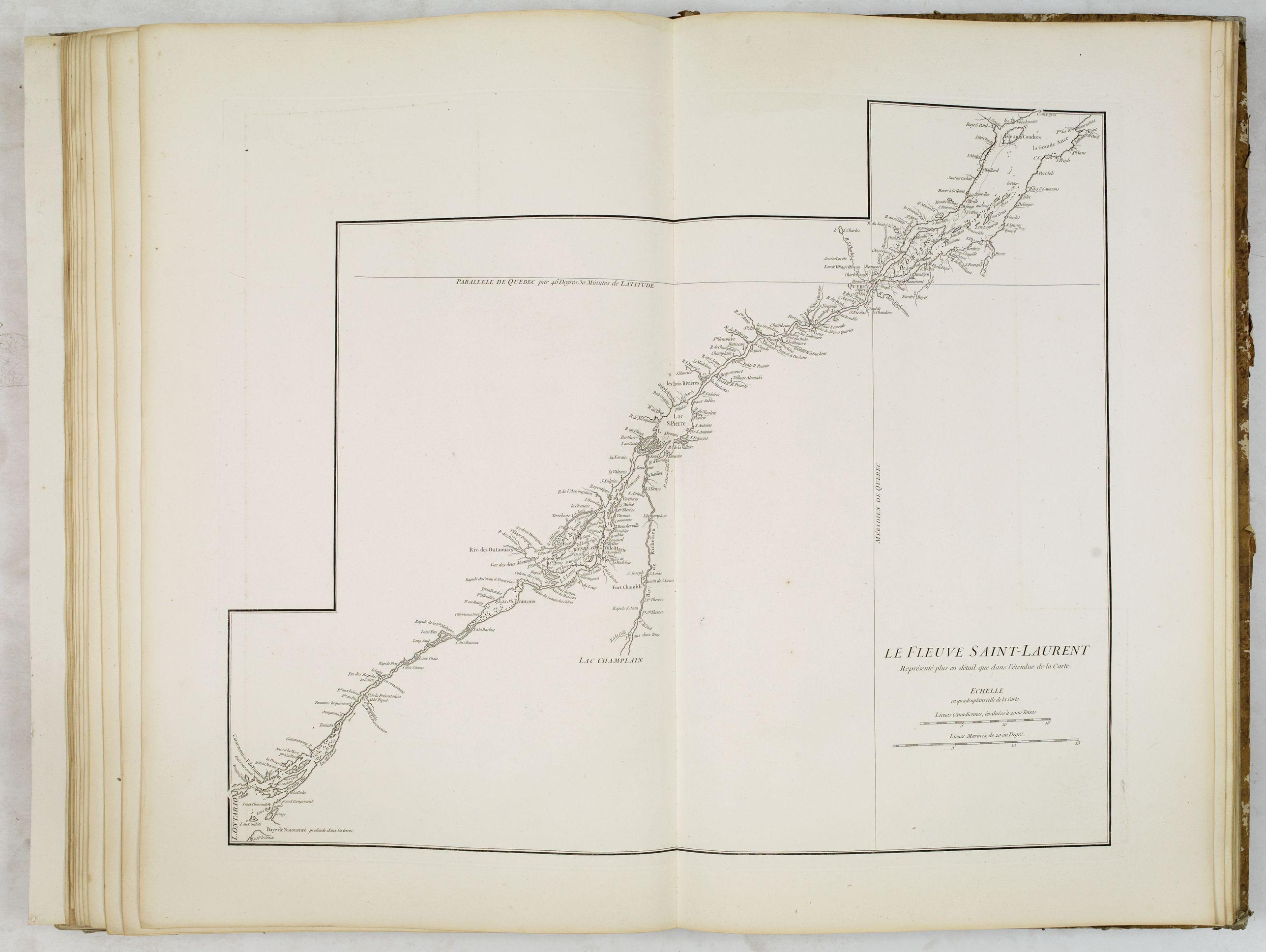
37. - Le Fleuve Saint-Laurent.
38. - Carte de la Louisiane (2 joined sheets).
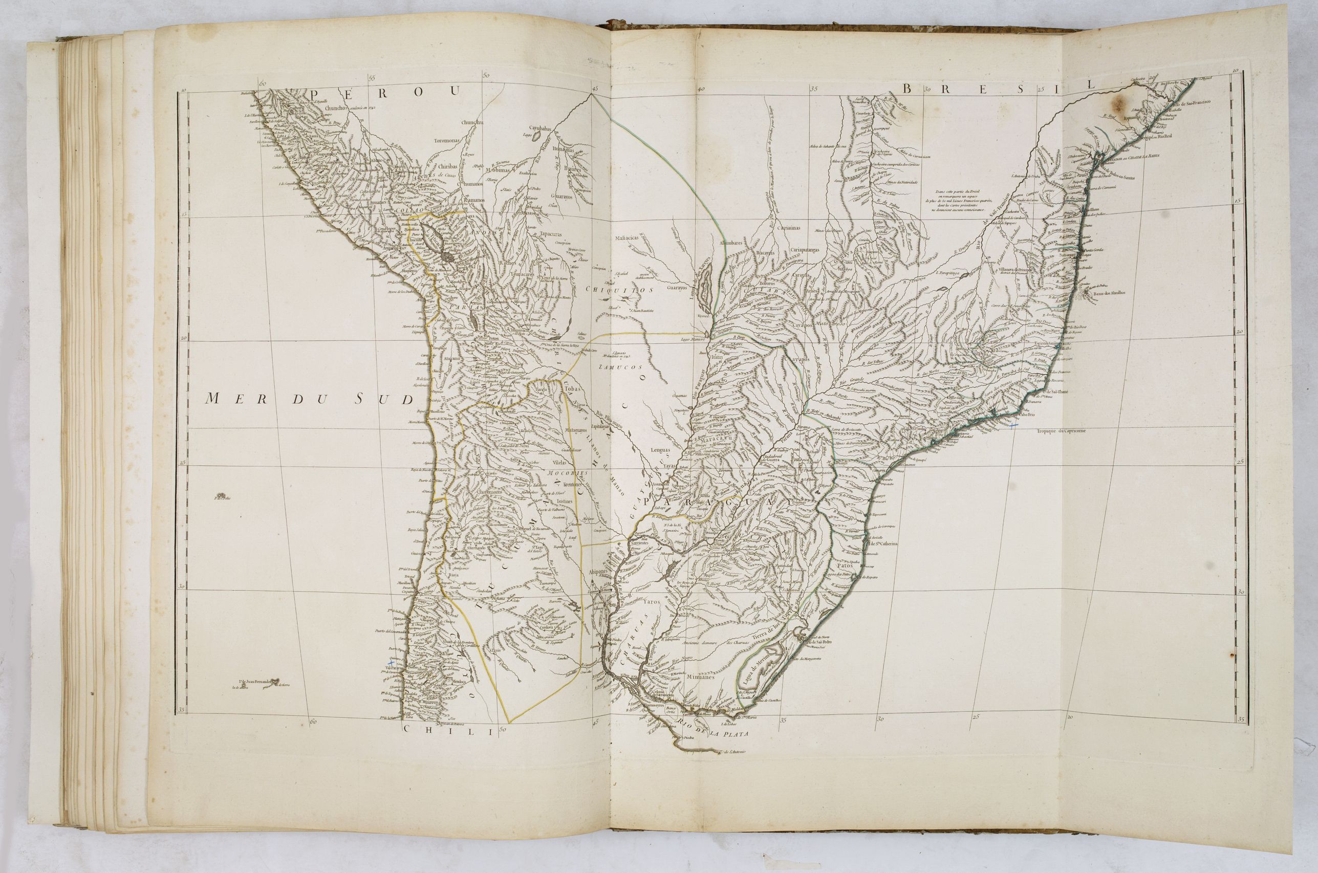
39. - Amérique méridionale ( 6-sheet map of South America, 2 joined sheets).
39a. - [Amérique méridionale] (2 joined sheets with 39 and 39b).
39b. - [Amérique méridionale] (2 joined sheets with 39 and 39a).
Bound with :
(40) - Printed letter press by d'Anville, Mémoire
instructif pour que dans toutes les paroisses d'un diocèse, il soit
dressé en meme-tems uniformément, par une mèthode aisée à pratiquer, des
cartes & des mémoires particuliers, qui puissent fournir un détail
suffisant pour la carte générale de ce diocése ou d'une province. A Paris, chez Louis-Denis Delatour, 1732. 4 pp. in-folio.
(41) - Anonymous manuscript in brown ink : Mémoire instructif pour faire la carte (de d'Anville). No date. 4 pp. in-4. Detailed description about how to draw a map.
(42) - Double page circulair projection with orientations and topographical icons and signs.
(43) - Carte topographique du diocèse de Lizieux.
(44) - Position des points discutés dans l'analyse géographique de l'Italie par le sr d'Anville.
(45)
- Parallèle du contour de l'Italie selon les cartes de MM. De l'Isle et
Sanson, et celle qui résulte de l'Analyse géographique de ce continent
par le s. d'Anville.
Although he apparently never left the city of Paris, he had access to the reports and maps of French explorers, traders, and missionaries. During his long career he accumulated a large collection of cartographic materials that has been preserved. He was particularly interested in Asia and produced the first reasonably accurate map of China in 1735.
He became Royal Geographer and Cartographer to the King of France in the middle of the eighteenth century, at a time when French cartography was still considered to be the best in the world.
He was the successor to Guillaume Delisle as the chief proponent of scientific cartography, and his influence on his contemporaries was profound.
To illustrate the cartography of the middle to the latter part of the eighteenth century a d'Anville map is essential. He was foremost in using the latest and most accurate cartographic information available. From the latest discoveries of the many French explorers to information available from explorers such as Cook and others. And unlike many cartographers of the day, he was not averse to leaving blank spaces in his maps where knowledge was insufficient.
R.V. Tooley write : "D'Anville was the finest cartographer of his time, his attention to detail was exemplary, his maps having a great delicacy of engraving".
Thomas Basset and Philip Porter write: "It was because of D'Anville's resolve to depict only those features which could be proven to be true that his maps are often said to represent a scientific reformation in cartography." (The Journal of African History, Vol. 32, No. 3 (1991), pp. 367-413).
D'Anville and Thomas Jefferson
D'Anville's maps draw on material gathered from several French expeditions made during the first half of the eighteenth century. At this time, the French were intent on finding a trade route to the western Indians and to Santa Fe and also on preempting Spanish expansion into the Mississippi River valleys.
Around 1720, Jean Baptiste Bénard de La Harpe undertook two expeditions to explore the Red and Arkansas Rivers and part of what is now Oklahoma. At roughly the same time, Claude-Charles du Tisné journeyed by land to the source of the Osage River and explored southeastern Kansas.
It is known that Thomas Jefferson acquired seven maps by d'Anville in 1787. Although the titles of the maps he acquired are not known, Jefferson must have been familiar with d'Anville's maps of North America, including "Carte de la Louisiane."
In a letter to Secretary of the Treasury Albert Gallatin relating to a newly commissioned map of North America, Jefferson discussed the use of d'Anville as a reference for the lower Mississippi basin.
Meriwether Lewis obtained a copy before the Lewis and Clark Expedition.
D'Anville's map "Carte de la Louisiane shows the Gulf Coast from the Tallahassee area to around the mouth of the Sabine in Texas, one of the best obtainable large format maps of the region from this period. The map tracks the Mississippi, Arkansas, Red, Osage and Missouri Rivers, and includes an excellent large inset of the Mississippi River Valley from the Arkansas to above the Missouri Rivers.
Most of the information was derived from Valentin Devin, who arrived in Pensacola in 1719 (under the auspices of John Law's Company of the West) and began producing highly regarded maps immediately upon his arrival on the Gulf Coast, until expelled by the Spanish after a three-year struggle. Devin used his information and materials gathered from Le Maire and others to produce a number of manuscript maps which were sent back to France and resulted in a series of maps by De L'Isle, Buache and finally d'Anville, whose maps of the Gulf Coast formed the standard for several years.
D'Anville's two-sheet map "Amerique Septentrionale". Publiee sous les auspices de Monseigneur le Duc d'Orleans, Premier Prince du Sang. Par le Sr. d'Anville, M DCC XLVI" depicts a "Grande Riviére" running to the west out of the "Lac des Bois" with a note that it was discovered by an Indian named Ochagac, or Ochagach, a reference to the accounts of La Vérendrye and his sons. The map labels the upper Missouri the "Pekitanoui R." Only the upper half of "Amérique Septentrionale" is exhibited. Shows boundaries of Treaty of 1763 and Ft. Duquesne.
References : Wagner, 552; Lowery, 382; Taliaferro, 134; Checklist of printed maps of the Middle West to 1900, 1-0598; Karpinski, LVIII; Tooley, Printed maps of America, 104; cf P571, 572, 599; NMM 200.
China and Korea
Jean Baptiste Bourguignon d’Anville beautifully printed and splendidly illustrated "Nouvel atlas de la Chine, de la Tartarie chinoise, et du Thibet" is the summation of European knowledge on China in the 18th-century. It was begun by the Jesuit missionaries to China in 1708, and their completed manuscripts were presented to the Emperor Kang-hi in 1718. Kang-hi ordered further surveys and from them were constructed the well-known maps forwarded to father Du Halde and used by d'Anville for this Du Haldes "Description … de l'empire de la Chine et de la Tartarie chinoise" (1736) and his Atlas (1737).
This atlas contains a very detailed two-sheet map of the Far East (map 22 and 22a) including China, Korea and Japan.
The map is dated 1752 and it becomes clear that he has incorporated the sources for of his "Nouvel atlas de la Chine".
Atlas in elephant folio (book block measuring 580x375 mm.), bound in contemp. half calf with gilted label on spine "ATLAS DE D'ANVILLE", 59 pages multi-sheet maps, actual map sheet count is 42. Maps dated 1743-1786. This set is accompanied by a 4 pages printed broadsheet "Mémoire instructif. . . En Mars MDCCXXXII D'Anville, Geographe ordinaire du Roy. Permis d'imprimer ce 21 Mars 1732, Herault" and 4 pages manuscript text in pen and brown ink "Mémoire instructif pour faire la carte (de d'Anville)..."
Very good condition inside the book block, the two sheet map of Africa has slight overall browning, the others printed on fine white thick paper and colored in outline.
The maps are copper engravings with original outline color; most are double pages, some folding, multi sheet maps. The first 39 maps have a number 1-39 in brown ink in a contemporary hand-on verso.
The cartouches on many of the maps are designed by his brother, Hubert-François Bourguignon, commonly known as Gravelot (26 March 1699 — 20 April 1773). Gravelot was a engraver, a famous book illustrator, designer and drawing-master. Born in Paris, he emigrated to London in 1732, where he quickly became a central figure in the introduction of the Rococo style in British design, which was disseminated from London in this period through the media of book illustrations and engraved designs as well as by the examples of luxury goods in the "French taste" brought down from London to provincial towns and country houses. The maps are engraved by the master engravers Guillaume De la Haye, Major, Delafosse.
Jean Denis Barbie Du Bocage (1760-1825)
Studied at the Mazarin College in Paris and became in 1777 the only pupil of Jean-Baptiste Bourguignon d'Anville.
In
1780, aged 20, he worked for the French Ministry of Foreign Affairs
and, from 1785 he worked for the library of "Cabinet des médailles de la
Bibliothéque du roi" and moved in 1792 to the Geography department in
the same part of the same library.
Since 1797 a member of "du
conseil de géographie du bureau du cadastre du ministère de l'intérieur"
and in 1802 he was responsible of various geographical works, among a
map of the Morea (Peloponnese) for the Ministry of War. From 1803 to
1809, he was a geographer at the Ministry of Foreign Affairs and became
the first professor of geography at the Faculty of Arts of Paris from
1809 to 1825.
He gathered a large collection of maps and geographic documents, his library was sold after his death in February 1850.
Being
a pupil of d'Anville, it was clear that Jean Denis Barbie Du Bocage was
asked to update the d'Anville maps after the Treaty of Paris (1783).
The very large two-sheet double hemisphere world map (over 3ft, 1m) who
was engraved by Guillaume Nicolas Delahaye in 1761 is heavenly updated
to 1786. The states of "Virginie", "Caroline" are removed and replaced
by "ETATS-UNIS". Alaska, Cape Cod, Savanah, S.Paul and the discoveries
of Captain Cook, including an early appearance of the Sandwich Islands
(Hawaii) are now added to the plate. The latest discoveries by Cook in
NW of America are also included. Bocage has included nearly all Cook's
detail of New Zealand.
In the western hemisphere, especially Australia, has many place names added.
FAQ - Guarantee - Shipping
Buying in the BuyNow Gallery
This item is available for immediate purchase when a "Add to Cart" or "Inquire Now" button is shown.
Items are sold in the EU margin scheme
Payments are accepted in Euros or US Dollars.
Authenticity Guarantee
 We provide professional descriptions, condition report (based on 45 years experience in the map business)
Paulus Swaen warrants the authenticity of our items and a certificate of authenticity is provided for each acquired lot.
Condition and Coloring
We indicate the condition of each item and use our unnique HiBCoR grading system in which four key items determine a map's value: Historical Importance, Beauty, Condition/Coloring and Rarity.
Color Key
We offer many maps in their original black and white condition. We do not systematically color-up maps to make them more sellable to the general public or buyer.
Copper engraved or wood block maps are always hand colored. Maps were initially colored for aesthetic reasons and to improve readability. Nowadays, it is becoming a challenge to find maps in their original colors and are therefor more valuable.
We use the following color keys in our catalog:
Original colors; mean that the colors have been applied around the time the map was issued.
Original o/l colors; means the map has only the borders colored at the time of publication.
Colored; If the colors are applied recently or at the end of the 20th century.
Read more about coloring of maps [+]
Shipping fee
A flat shipping fee of $ 30 is added to each shipment by DHL within Europe and North America. This covers : International Priority shipping, Packing and Insurance (up to the invoice amount).
Shipments to Asia are $ 40 and rest of the world $50
We charge only one shipping fee when you have been successful on multiple items or when you want to combine gallery and auction purchases.
Read more about invoicing and shipping
FAQ
Please have a look for more information about buying in the BuyNow gallery
Many answers are likely to find in the general help section.
My Collection+
![]()
With My Collection+ you can collect all your favorite items in one place. It is free, and anyone can create his or her virtual collection.
Unless you are logged in, the item is only saved for this session. You have to be registed and logged-in if you want to save this item permanently to My Collection+.
Read More[+]
Register here, it is free and you do not need a credit card.
Add this item to
My Collection+
or click the following link to see My Collection+.
| Digital Image Download | |
|
Paulus Swaen maintains an archive of most of our high-resolution rare maps, prints, posters and medieval manuscript scans. We make them freely available for download and study. Read more about free image download |
Click the image for a free small image download. |
In accordance with the EU Consumer Rights Directive and habitually reside in the European Union you have the right to cancel the contract for the purchase of a lot, without giving any reason.
The cancellation period will expire 14 calendar days from the day after the date on which you or a third party (other than the carrier and indicated by you) acquires, physical possession of the lot. To exercise the right to cancel you must inform Paulus Swaen Inc, of your decision to cancel this contract by a clear statement (e.g. a letter sent by post, or e-mail.
To meet the cancellation deadline, it is sufficient for you to send your communication concerning your exercise of the right to cancel before the cancellation period has expired.
