Subscribe to be notified if similar examples become available.
JAILLOT, A.H. Theatre de la Terre Saincte qui represente les lievx ou sont faits les miracles combats et belles actions contenves au Vieil et Nouveau Testament. . 640 x 1357mm. |
||||||||||||||||||||
|
||||||||||||||||||||
|
|
||||||||||||||||||||
No price info available. |
Virtual Collection - Save and collect this or any of your favorite items in one place.
If you want to save the items permanently, please sign in or create account first. |
|||||||||||||||||||
Description
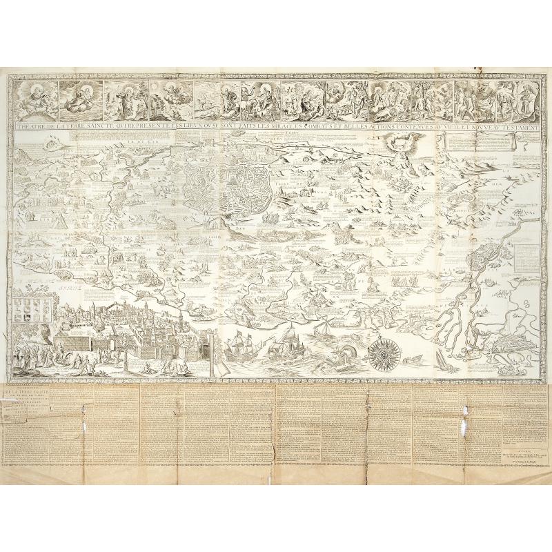
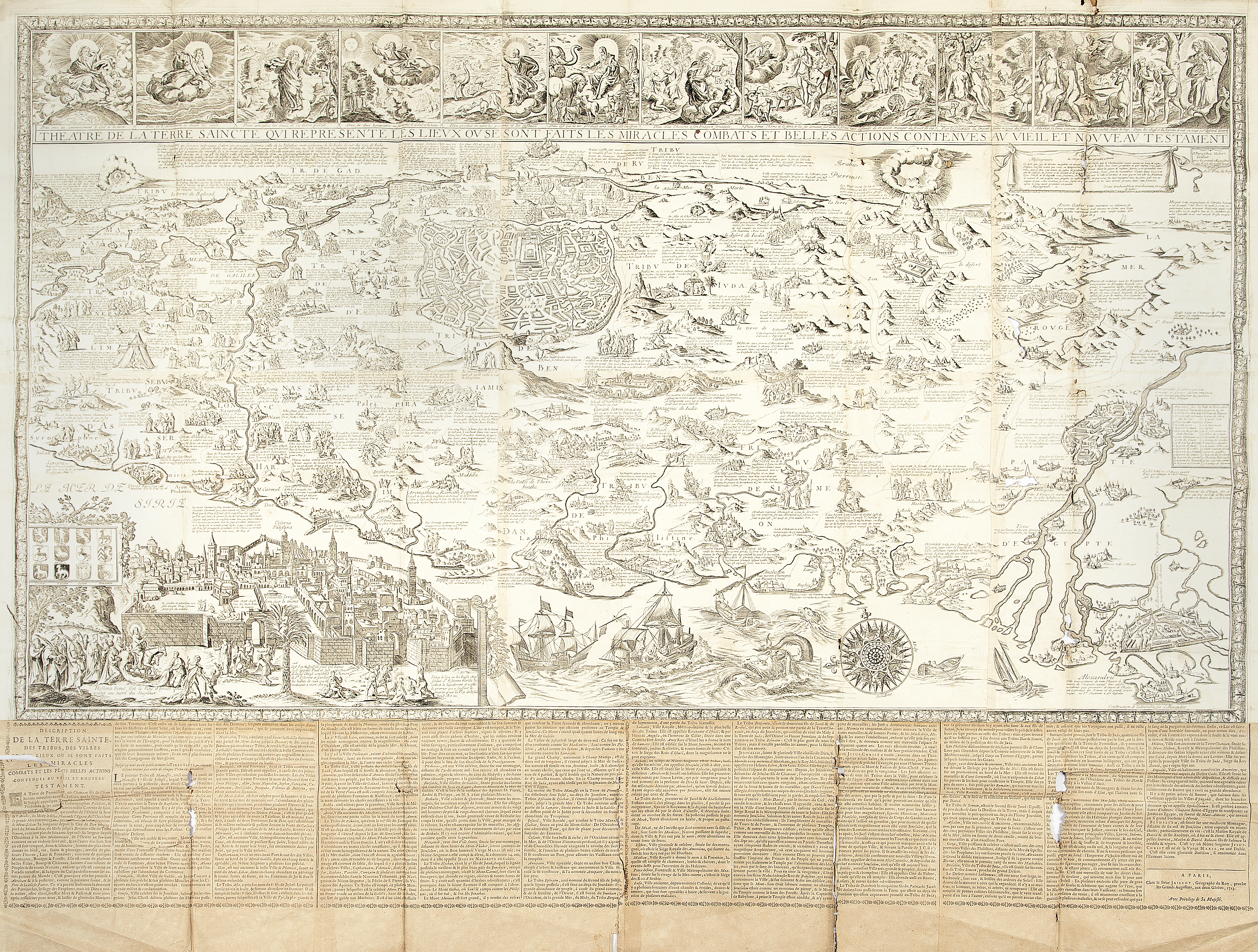
Important wall map of the Holy Land printed from six copperplates. Six sheets joined with a descriptive text pasted along the bottom. Dimensions of the map comprising the 12 vignettes : 794 x 1390 mm.
A very important wall-map of the Holy Land of which only 2 other copies are known. The map is dated 1697 and is signed by Jaillot himself. Oriented to the east, showing, at top middle, a large town plan of ancient Jerusalem and, bottom left, a view of modern Jerusalem. In the upper part above the “Red Sea”, the town of Mecca has been represented and is called : « Mecque Ville magnifique de l’Arabie heureuse en la puiss.ce des Turcs les quels y vont en pèlerinage pour honorer Mahomet, quils croient y estre né, et ou est le lieu de Sa Sépulture devant laquelle trois mil cierges brusle incessament ».
The shore line running from Sidon to Alexandria and inland from the Mediterranean to the east bank of the Jordan. The map figures numerous biblical places, facts or events like an illustration showing Jonah being thrown from a vessel into the sea, and the whale opening its mouth. The map is illustrated with small plans and views of the main towns and drawings representing the main events in the Bible. Along the top, 12 vignettes showing scenes of the Creation until the Expulsion of Adam and Eve from Paradise. Pasted to the map, along the bottom, a descriptive text : “Description de la Terre Sainte…”, signed : A Paris, Chez le Sieur Jaillot, 1723.
A cartouche, in the upper right corner surrounded with draperies, serves as introduction and as dedication to the subject : “À Messeigneurs du clergé de France, assemblé à Paris” (To the Lords of the clergy of France, assembled in Paris). The text at the bottom is entitled “Description de la Terre Sainte, des tribus, des villes et des lieux ou sont faits les miracles… ” (Description of the Holy Land, the tribes, cities and places where are made the miracles), dated 1723 and was doubtless added by his son.
The map resembles Allard’s wall map of the Holy Land. The plan of Jerusalem is after Visscher.
Two other recorded examples: Eran Laor Cartographic Collection at the Jewish National and University Library in Jerusalem, the other example in the collection of the “Treasury of Liege”, but this example is without the descriptive text.
Reference: Laor, Maps of the Holy Land, 370.
Reference: Laor, Maps of the Holy Land, 370.
FAQ - Guarantee - Shipping
Buying in the BuyNow Gallery
This item is available for immediate purchase when a "Add to Cart" or "Inquire Now" button is shown.
Items are sold in the EU margin scheme
Payments are accepted in Euros or US Dollars.
Authenticity Guarantee
 We provide professional descriptions, condition report (based on 45 years experience in the map business)
Paulus Swaen warrants the authenticity of our items and a certificate of authenticity is provided for each acquired lot.
Condition and Coloring
We indicate the condition of each item and use our unnique HiBCoR grading system in which four key items determine a map's value: Historical Importance, Beauty, Condition/Coloring and Rarity.
Color Key
We offer many maps in their original black and white condition. We do not systematically color-up maps to make them more sellable to the general public or buyer.
Copper engraved or wood block maps are always hand colored. Maps were initially colored for aesthetic reasons and to improve readability. Nowadays, it is becoming a challenge to find maps in their original colors and are therefor more valuable.
We use the following color keys in our catalog:
Original colors; mean that the colors have been applied around the time the map was issued.
Original o/l colors; means the map has only the borders colored at the time of publication.
Colored; If the colors are applied recently or at the end of the 20th century.
Read more about coloring of maps [+]
Shipping fee
A flat shipping fee of $ 30 is added to each shipment by DHL within Europe and North America. This covers : International Priority shipping, Packing and Insurance (up to the invoice amount).
Shipments to Asia are $ 40 and rest of the world $50
We charge only one shipping fee when you have been successful on multiple items or when you want to combine gallery and auction purchases.
Read more about invoicing and shipping
FAQ
Please have a look for more information about buying in the BuyNow gallery
Many answers are likely to find in the general help section.
Virtual Collection
![]()
With Virtual Collection you can collect all your favorite items in one place. It is free, and anyone can create his or her Virtual map collection.
Unless you are logged in, the item is only saved for this session. You have to be registed and logged-in if you want to save this item permanently to your Virtual Collection.
Read More[+]
Register here, it is free and you do not need a credit card.
Add this item to
Virtual Collection
or click the following link to see my Virtual Collection.
| Digital Image Download | |
|
Paulus Swaen maintains an archive of most of our high-resolution rare maps, prints, posters and medieval manuscript scans. We make them freely available for download and study. Read more about free image download |
Click the image for a free small image download. |
In accordance with the EU Consumer Rights Directive and habitually reside in the European Union you have the right to cancel the contract for the purchase of a lot, without giving any reason.
The cancellation period will expire 14 calendar days from the day after the date on which you or a third party (other than the carrier and indicated by you) acquires, physical possession of the lot. To exercise the right to cancel you must inform Paulus Swaen Inc, of your decision to cancel this contract by a clear statement (e.g. a letter sent by post, or e-mail (amsterdam@swaen.com).
To meet the cancellation deadline, it is sufficient for you to send your communication concerning your exercise of the right to cancel before the cancellation period has expired.

