The first sea atlas
Le Nouveau miroir des voiages marins de la navigation de la mer occidentale & orientale. WAGHENAER, L. J.[ Antwerp, Chez Iean Bellere, a l’Aigle d’or, l’An M.CCCCCC (1600)
2 parts in one volume. Folio (42.2 x 28 cm), brown morocco, two gilt fillets framing the covers, gilt arms in the center, smooth spine decorated with gilt motifs, gilt edges. (contemporary binding). [2] ff., 36 p., 48) double-page plates, ff., [4] ff (n° 18.2, second engraved title and bifolium n° XXVII.3), [4] ff.
A second and final French edition of this important sea atlas. Two engraved frontispieces, figure with volvelle, full-page figure, 48 double-page charts (one numbered 19.2) and two small maps, all engraved on copper, and 22 profiles engraved in wood, including 4 full-page.
P.O.R.
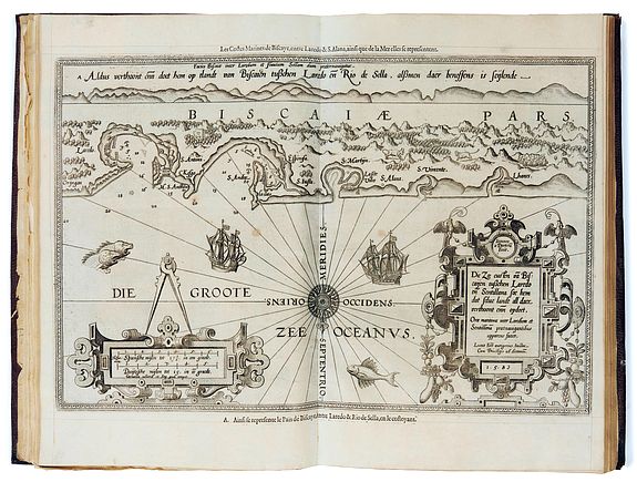
A superb and famous work of maritime navigation, it was published for the first time in Dutch in 1583 under the title Spieghel der Zeevaerdt. The atlas was very innovative because it combined nautical charts with coastal profiles, and its success was immediate and considerable. Waghenaer systematically combines the coastal chart with a matching coastal profile on a uniform scale of 1:400.000. On all the charts, we find sea monsters, and there are detailed drawings of ships. After 1585, some new editions of Van Waghenaer's Sea Atlas were published in Latin, German, English, and French. Initially, the charts had Dutch titles and profile texts. At a later stage, the titles were engraved again and a Latin title was added.Each title page bears a printed paper slip masking the engraved title cartouche of the 1583 edition. A very fine regulated example with the arms of the Martin de La Roque family, some members of which held positions in Bordeaux during the time of Michel de Montaigne. Chart 1 is supplied from another example. Very dark impressions.
Provenance : Baritau (handwritten ex-libris on the endpapers). Count of Marcellus (handwritten ex-libris on the endpapers).
In the first part, the sea chart of Europe and the western part of Northern Africa is followed by 22 detailed maps of parts of the European coast: from the southern tip of the island of Texel to Spanish Cádiz. These are the coasts of the so-called western navigation. The second part contains the maps of the coasts northeast of Texel, i.e. the eastern navigation. Waghenaer's sea atlas revolutionized navigational chart making, that all English sea-atlases were commonly called 'waggonar' well into the 18th century.
Waghenaer (c. 1533-1606) was a Dutch marine cartographer and navigator. He grew up in the important port of Enkuizen. From 1550-1579 he served at sea, increasing his practical knowledge of sailing and charting.
Waghenaer published two other works, Thresoor der Zeevaert ( Treasure of navigation) in 1592 and the Enchuyser zeecaertboeck (Enkhuizen sea-chart-book) in 1598.
The outstanding engraving of the charts was done by Joannes Doetecum, who came from a family of printmakers from Deventer.
