Manuscript chart on vellum of the Java Sea by Isaac de Graaf.
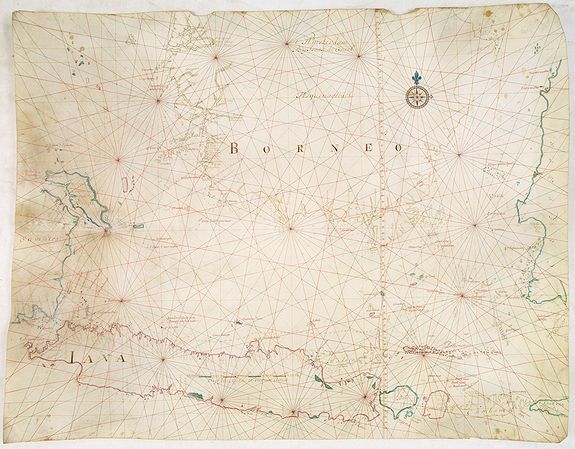
GRAAF, I. = [Manuscript chart on vellum of the Java Sea] Amsterdam, 1743. Size: 30 x 39 inches. / 76 x 99cm.
Pen, ink and gouache on vellum: strong and resistant to all kinds of weather. Very good condition.
One of the few manuscript charts on vellum in private hands, signed by Isaac de Graaf. ORIGINAL MANUSCRIPT MAP IN RED, GREEN AND BLACK INK showing the Java Sea centered on the Island of Java, Southern part of Borneo and parts of Sumatra and with Bali Island nearby.
P.O.R.
One decorative compass rose and Chart maker's name in top "'t Amsterdam Bij Isaak de Graaf. One sophisticated scale bar within Java : Duijtsche Mijlen 15 voor een Graat.
The place of origin and the chart maker's name are located centrally at the top of the chart. No date is reported. One decorative secondary compass rose (NE) is situated at the upper right. In a contemporary hand on the verso in the left and right outer margin, "Detroit's debanca, de Sonde, de baly, Islles de Java, Celebes, borneo, de Sumatra".
The chart's content, handwriting, and compass rose are similar to those of a chart dated 1742, mentioned in H. Kok, Sailing for the East: History Catalog of Manuscript Charts on Vellum of the Dutch East India Company (VOC) 1602-1799 (7.17). This chart is listed as No. 7.18 and has the date 1743, attributed by Prof. Gunter Schilder and Hans Kok, based on additional islands drawn in on this example.
Contrary to the south coast, the number of toponyms along the northern coast is much larger and often uses local names.
Prof. Schilder has found only 5 examples of charts of the Java Sea that are signed by Isaak de Graaf. As Isaak de Graaf died in 1743, this must have been one of the last charts made by the Master and map maker of the V.O.C.
Provenance : USA Private collection.
Isaak de Graaf
Famous for his work, Isaak de Graaf (1667 - 5 September 1743), the Dutch cartographer, is one of the greatest mapmakers of his time. Isaak de Graaf was born to Susanna Pietersz Eppingh and Abraham de Graaf in the year 1668. Since his father Abraham de Graaf was also a renowned cartographer, Isaak de Graaf had the privilege of taking navigation lessons from a very young age.
He started his career as a clerk cum cartographer in the Amsterdam Chamber of the Dutch East India Company. Soon he was appointed the supervisor of the Atlas Amsterdam.
As a reward for his excellent work, the Vereenigde Oostindische Compagnie, or the East India Company, deputed him as the official cartographer in the early 18th century.
The instructions given by the Amsterdam Chamber on 3 August 1705 have been preserved and indicate what sort of work was expected of him. The provisions in this diverge only slightly from those given to his first predecessor Hessel Gerritsz. almost a century earlier.
Like his predecessors, alongside the Atlas Amsterdam, Isaak de Graaf fulfilled a vast and permanent task in making certain basic maps (leggers), which served his assistants as examples in the multiple copying of charts to be used on Company ships.
In his instructions, Isaak de Graaf was told he should "... correct, improve, and amplify the charts for the fleet so that the ships, in service both outward- and homeward-bound and in the Indies, might have the best indications, and sail the safest routes so that their voyages may proceed and come to a safe completion".
For nearly forty years, De Graaf was therefore responsible for equipping VOC ships with hand-drawn charts and navigational instruments.
Another part of De Graaf's duties was the complete revision of the standardized list of charts and navigational instruments which were used as a check when the ships were being fitted out for the journey to the Far East.
In what is known as the Kahier van de Personeele Quotatie te Amsterdam over het jaar 1742, the Amsterdam tax records for 1742, Isaak de Graaf is listed as a capitalist, enjoying an income of 2500 guilders.
Isaak de Graaf got married to Saderina de Brauw and served the Dutch East India Company till death.
He died on 5 September 1743, at an age of seventy-five, after an industrious life of more than half a century as map-maker to the Amsterdam Chamber of the VOC.
The Dutch East India Company was a well-organized company with strict rules governing ship equipment. Lists were kept of the navigation material that had to be taken on board. The master mariner and petty officers had to sign to show they had received the material in question. They also had to undertake to surrender the material upon arrival in Batavia. On board each Dutch East India Company ship there were paper and vellum maps and charts. Created from animal skin, vellum is strong and withstands weather and frequent use well. Dutch East India Company charts on vellum were almost always drawn by hand.
Compass rose.
A prominent feature, shown on early sea charts, consists of the compass rose. They derive from the earlier wind roses, as in Mediterranean portolans, where directions were referenced to prevailing winds, until the magnetic compass was introduced.
This compass rose is fully drawn and beautifully coloured. As usual, it is located within a landmass and out of the way of the shipping route, so it would not interfere with its navigational purpose.
According to Prof. Schilder and Hans Kok "Compass roses have developed from impressing embellishments in the sixteenth century to almost austere renderings of navigational aid by the end of the eighteenth century. They may also have served as a commercial incentive and as an indication of the chart makers' workshop, and are probably to be considered an early company logo.
However, the map currently helps identify the chart maker, or even the draughtsman who produced the chart, as they remained typical over time and thus provide valuable information.
Several of the compass-roses by Isaak de Graaf at the end of his life have a small, filled-in square grid box to the east point of the rose. An identical compass rose by Isaak de Graaf is illustrated in Sailing for the East, page 233, ill.13.7.
Reference:
H. Kok / Gunter Schilder Sailing for the East: History Catalog of Manuscript Charts on Vellum of the Dutch East India Company (VOC) 1602-1799, (Houten, 2010), Map 7.18
Further reading
- Paesie, R., Zeeuwse kaarten voor de VOC : het kaartenmakersbedrijf van de Kamer Zeeland in de 17de en 18de eeuw. (‘Zeeland maps for the Dutch East India Company: the map makers’ company of the Zeeland chamber in the 17th and 18th centuries’) (Zutphen, 2010).
- 'Op perkament getekend: productie en omvang van het hydrografische bedrijf van de VOC' (‘Drawn on parchment: production and size of the hydrographic company of the Dutch East India Company’). In: Caert-Thresoor 29.1 (2010), p. 1-8.
- Schilder, G., 'Een zeereis naar Indië in de achttiende eeuw' (‘A journey by sea to India in the eighteenth century’). In: Marco van Egmond, Bart Jaski and Hans Mulder (eds.), Bijzonder onderzoek : een ontdekkingsreis door de Bijzondere Collecties van de Universiteitsbibliotheek Utrecht (‘Special research: a voyage of discovery through the special collections of the University Library’) (Utrecht , Zwolle, 2009), p. 188-195.
- Gunter Schilder, H. Kok, Sailing for the East: History Catalog of Manuscript Charts on Vellum of the Dutch East India Company (VOC) 1602-1799 (Houten, 2010).
