Browse Listings in Africa > Central Africa

.Tabu nova partis Aphri.
This is Laurent Fries' 1535 edition of the earliest acquirable modern mapping of Africa north of the Equator.Based on Waldseemüller's map. The maps show Northern Africa ...
Date: Lyons, M. Servetus, 1535

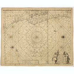
Carta particolare che comincia con il c.apo Aldea è Finisce con il capo Degortam. . .
Dudley’s magnificent chart shows the south west coast of Africa with the Tropic of Capricorn, located at about 23.5 degrees south. Without the privilege, but with "...
Date: Florence, 1645

Paskaart van Guinea van C.Verde tot R. deGalion.
Rare edition of Doncker's sea chart of Guinea coast. From an atlas printed in 1668, "l'Atlas de MER ou MONDE AQUATIQUE, Remontrant toutes lescôtes de la Mer…"...
Date: Amsterdam, 1660-1668
Pascaart van de zee-custenvan Angola, en Cimbedas van Rivier de Galion tot C. de Bona Esperanca.
Rare Doncker's sea chart of the West Coast of Africa, from Angola to the Cape of Good Hope, with a larger inset map of the area from St. Martin's Bay to the Cape of Good ...
Date: Amsterdam, 1660-1668
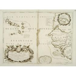
Bocche del Fiume Negro et Isole di Capo Verde.
Double-page engraved map of the Cape Verde Islands and part of the coast of Senegal, with large decorative cartouche. One with inset of the island Goree. During three cen...
Date: Venice, 1690
![Loandas St.Paulo [Luanda]](/uploads/cache/48500-250x250.jpg)
Loandas St.Paulo [Luanda]
Engraved by Thomas Doesburgh (active between 1683 and 1714) for Carolus Allard's Orbis habitabilis oppida et vestitus, the print shows a distant view of the Angolese ci...
Date: Amsterdam, c. 1685-1690
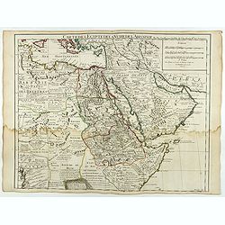
Carte de L'Egypte de la Nubie de L'Abissinie..
Including the Arabian Peninsula. Giving good detail on Egypt. Engraved by Desrosiers. Address and date changed, now with the imprint "A Paris Chez l’Auteur sur le ...
Date: Paris, November 1707

Pas-Kaat vaneen gedeelte van de Aethiopische Zee behelsende de Kusten Zanguebar, Ajan en Abex, en een gedeelte van de Arabische Kust. . .
A finely engraved and detailed chart of the most eastern tip of Africa, including Somalia, Djibouti, Yemen, Mauritius, and many other islands in the Indian Ocean.Very rar...
Date: Amsterdam, 1753
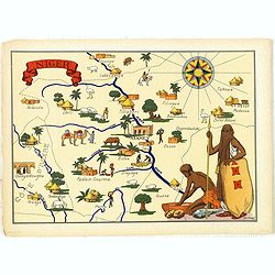
Niger.
Very decorative, informative map of Nigeria. The map is filled with buildings, animals, figures and two locals. With a large compass rose in upper right corner.In lower l...
Date: France, 1943
